Autonomous Localization
by
Qiang Liu
A thesis submitted for the degree of
Doctor of Philosophy
School of Computer Science and Electronic Engineering
University of Essex
Environment maps are essential for robots and intelligent gadgets to autonomously carry out tasks. Traditional maps built by visual sensors include metric ones and topological ones. These maps are navigation-oriented and not adequate for service robots or intelligent gadgets to in-teract with or serve human users who normally rely on conceptual knowledge or semantic con-tents of the environment. Therefore, semantic maps become necessary for building an effective human-robot interface. Although researchers from both robotics and computer vision domains have designed some promising systems, mapping with high accuracy and how to use semantic information for localization remain challenging.
This thesis describes several novel methodologies to address these problems. RGB-D visual data is used as system input. Deep learning techniques and SLAM algorithms are combined in order to achieve better system performance. Firstly, a traditional feature based semantic mapping approach is presented. A novel matching error rejection algorithm is proposed to in-crease both loop closure detection and semantic information extraction accuracy. Evaluational experiments on public benchmark dataset are carried out to analyze the system performance. Secondly, a visual odometry system based on a Recurrent Convolutional Neural Network is presented for more accurate and robust camera motion estimation. The proposed network de-ploys an unsupervised end-to-end framework. The output transformation matrices are on an absolute scale, i.e. true scale in the real world. No data labeling or matrix post-processing tasks are required. Experiments show the proposed system outperforms other state-of-the-art VO sys-tems. Finally, a novel topological localization approach based on the pre-built semantic maps is presented. Two streams of Convolutional Neural Networks are applied to infer locations. The additional semantic information in the maps is inversely used to further verify localiza-tion results. Experiments show the system is robust to viewpoint, lighting condilocaliza-tion and object changes.
Firstly, I would like to express my sincere gratitude to my supervisor Prof. Huosheng Hu. He is a man full of wisdom. He is always passionate and very kind to everyone around him. Many thanks for his academic advices on my research. It is him who guided me into the robotics field and showed me how to start a research, from choosing a topic until writing this thesis. Many thanks for his patience in countless discussions on the research methodologies. Apart from his guidance on my research, I would also like to thank him for helping me develop other generic skills that will be useful in my future career, e.g., language competence, presentation and demonstration skills, teaching skills and how to carry out a project. Many thanks for his financial support during the past four year. His passion about both research and life will inspire me in my whole life.
Beside my supervisor, I would like to thank Prof. Dongbing Gu, who also gives me a lot of advice on my research and study. He is always calm and offers his honest suggestions on my daily life. Many thanks to Prof. Huijun Gao, who supports me to continue my PhD study in the UK. Many thanks to my board meeting chief, Dr. Sam Steel, for checking my research progress and giving me useful advices. My thanks also go to Mr. Robin Dowling and Mr. Ian Dukes for their kind assistant with various technical problems when I carried out my experiments, as well as countless tea times in the afternoon. My sincere thanks also goes to Dr. Sen Wang and Dr. Ling Chen, who give me useful academic advices and help me settle down in the UK. Many thanks to my close friend, Dr. Ruihao Li, who provides great help for each of my publications. His lifestyle also inspires me to get rid of my bad habits.
I thank my fellow lab-mates, my friends in the UK for their accompany during my PhD study. Thank Fang Wang, Yan Zhuang, Yisha Liu, Yi An, Yiming Xu, Guan Lu, Guochen Wang, Wenju Zhou, Hong Liu, Jing Gao, Xunyu Zhong, Juan Yu, Yuanping Xie, Lisheng Wei, Chao Zhang, Jianjun Gui, Cheng Zhao, Shuofei Yang, Wanxin Zhang, Qi Zhang, Can Zuo,
vi
Tong Pei, Xiaoran Yang, Qian Wang, Kezhi Wang, Tianlang Peng, Yaser Ibrahem, Wesam Jasim, Minhuan Guo, Jialin Liu, Aakash Soni, Dingtian Yan, Zuyuan Zhu, Tuo Feng, Xiaoqi Nong, Penny Roberts, Xiaozhen Cai, Mark Boo, Alexander Jegorov, Xinye Zhang, Kikillo Secas, Gonzillah Monstah, Dunja Mrvic, Mihail Ciobanu, etc., for bringing joy to my life and encouraging me to moving forward each day.
Last but not the least, I would like to thank my family. Many thanks to my parents for raising me up and supporting me spiritually throughout writing this thesis and my life in general.
Abstract iii
Acknowledgment vi
Table of Contents ix
List of Figures xi
List of Tables xiii
List of Algorithms xv
Notation and Nomenclature xviii
List of Acronyms xxi
1 Introduction 1
1.1 Motivations . . . 1
1.2 Objectives and Challenges . . . 3
1.3 Research Methodologies . . . 5
1.4 Thesis Contributions . . . 6
1.5 Thesis Outline . . . 7
2 Background Review 11 2.1 Introduction . . . 11
2.2 Visual Features Used in Semantic Mapping Systems . . . 15
2.2.1 Global Features . . . 15 vii
viii CONTENTS 2.2.2 Local Features . . . 17 2.3 Recognition Approaches . . . 24 2.3.1 Global Approaches . . . 24 2.3.2 Local Approaches . . . 25 2.3.3 Hybrid Approaches . . . 26
2.3.4 Deep Learning Based Approaches . . . 27
2.4 Semantic Representation . . . 28
2.5 Typical Applications . . . 30
2.5.1 Indoor Applications . . . 30
2.5.2 Outdoor Applications . . . 33
2.6 Summary . . . 35
3 Building Semantic Maps for Human-Robot Interaction 37 3.1 Introduction . . . 37
3.2 Feature Based Metric Map Building Method . . . 39
3.2.1 Feature Extraction . . . 41
3.2.2 Transformation Estimation . . . 41
3.2.3 Loop Closure Detection . . . 44
3.2.4 Graph Optimization . . . 44
3.2.5 Point Cloud Generation . . . 45
3.3 Semantic Information Extraction . . . 45
3.4 Experimental Results . . . 46
3.4.1 3D Mapping . . . 46
3.4.2 Semantic Information Extraction . . . 55
3.5 Summary . . . 57
4 Using Unsupervised Deep Learning Technique for Monocular Visual Odometry 59 4.1 Introduction . . . 60
4.2 The Proposed Approach . . . 63
4.2.1 System Architecture . . . 66
4.2.2 Loss Function . . . 68
4.3 Experiments . . . 73
4.3.1 Training . . . 73
4.3.2 Performance Evaluation . . . 77
4.4 Summary . . . 90
5 Indoor Topological Localization Based on Deep Learning Technique 93 5.1 Introduction . . . 93
5.2 Preliminaries . . . 96
5.2.1 Semantic Information Extraction and Representation . . . 96
5.2.2 Topological Localization . . . 98 5.3 Experiments . . . 102 5.3.1 Training . . . 102 5.3.2 Experimental Evaluation . . . 107 5.3.3 Factorξ . . . 115 5.3.4 Processing Time . . . 116 5.4 Summary . . . 117 6 Conclusion 119 6.1 Research Summary . . . 119 6.2 Thesis Contributions . . . 120 6.3 A List of Publications . . . 122 6.4 Future Work . . . 123 Bibliography 125
1.1 Structure of this thesis. . . 8
2.1 Metric map [1]. . . 12
2.2 Topological map [2]. . . 13
2.3 Overview of the general process for semantic mapping. . . 14
2.4 Definition of local visual features in computer vision. . . 18
2.5 The spatial and conceptual hierarchy interrelated by anchoring. . . 29
2.6 The final semantic map obtained by Pronobiset al.[3] . . . 31
2.7 Robot navigation based on semantic map. . . 32
2.8 Interaction between the robot and the kitchen facilities [4]. . . 33
2.9 Outdoor applications of semantic maps. . . 34
3.1 System overview. Blue boxes: inputs and output. Orange boxes: mapping process. Green boxes: semantic information extraction process. . . 40
3.2 Number of good matches. . . 47
3.3 3D mapping test in our lab. . . 49
3.4 3D mapping test on the benchmark dataset. . . 53
3.5 A plain colour box showing the recognized laptop in the 3D map. . . 54
3.6 Student accommodation. . . 55
3.7 3D map of the student accommodation with red line representing the trajectory of the camera. . . 56
4.1 Overview of the proposed visual odometry system. . . 61
4.2 Architecture of the Convolutional Neural Network with input images. . . 64
4.3 Architecture of the Recurrent Neural Network with output poses. . . 65 xi
xii LIST OF FIGURES
4.4 Training overview. . . 73
4.5 Data augmentation. . . 74
4.6 Region of interest for loss calculation. Ignored region is grayed out. X-axis: cropped from 15 to 401. Y-axis: cropped from 53 to 126. . . 75
4.7 Training loss. X-axis: training steps. Y-axis: total loss. . . 76
4.8 Change of disparity during training. . . 76
4.9 Trajectories of KITTI Odometry Sequence 00 and Sequence 02-10. . . 82
4.10 Trajectories of KITTI Odometry Sequence 11-20. . . 89
5.1 Semantic mapping process. Blue boxes: 3D scene construction process. Orange boxes: semantic information extraction process. . . 97
5.2 An environment map for a flat . . . 98
5.3 An environment map for an office floor . . . 99
5.4 Semantic information representation. . . 100
5.5 Topological localization method with one query image. . . 101
5.6 Test images showing the importance of the factor. . . 104
5.7 Some of the training images at different locations. . . 105
5.8 Model precision evaluation in the case of fine-tuning among all layers. X-axis: training steps. Y-axis: precision. . . 106
5.9 Raw cross-entropy loss. . . 106
5.10 Model precision evaluation in the case of fine-tuning only the final layer. X-axis: training steps. Y-X-axis: precision. . . 107
5.11 Example images of kitchen with lighting condition change. . . 111
5.12 Lighting condition change evaluation (ξ = 1.3). . . 111
5.13 Example blurry images for testing. . . 113
5.14 Blurry image evaluation (ξ = 1.3). . . 113
5.15 Example showing how localization results can be verified by detecting objects. 114 5.16 Object change evaluation (ξ = 1.3). . . 115
2.1 Global features for object recognition in semantic mapping systems. . . 16 2.2 Local features for object recognition in semantic mapping systems. . . 19 3.1 Performance analysis based on the benchmark and our dataset. . . 49 3.2 Performance comparison between our algorithm and the one presented in [5]
based on RMSE of ATE values. (unit: meter) . . . 54 4.1 Specifics of the convolutional layers. . . 67 4.2 Translational and rotational errors. VISO2-Stereo results are provided as a
ref-erence. SfMLearner poses are post-processed with ground truth poses for scale recovery. Sequence 09 and 10 are not used for training. . . 84 5.1 Distinctive objects found at each location. . . 108 5.2 The average processing time of one image. . . 117
3.1 Feature based semantic mapping. . . 42 4.1 Implementations of the RCNN and loss functions. . . 72 5.1 Topological localization scheme. . . 101
s scale factor
pi, qi a pair of matched points
Qi associated 3D point ofqi
Fp RGB image with good matches
FQ depth image with good matches
(uqi, vqi) 2D coordinates of a point in a monocular image
(xQi, yQi, zQi) 3D coordinates of a point in a point cloud
(fx, fy) focal lengths expressed in pixel units
(cx, cy) a principal point that is usually at the image center
ˆ
R estimated rotation matrix
ˆ
T estimated translation matrix
ki camera pose
e error function
Nc number of good matches in the candidate key-frame
Nn number of good matches in the neighbouring key-frame
ξm ratio of good matches in the candidate and neighbouring key-frame
It monocular image
Dt depth image
dt depth value of a point in the depth image
pt a pixel in a monocular image
ˆ
pt projected point
Pt a voxel in a point cloud
K camera intrinsic matrix
xviii LIST OF ALGORITHMS
L2D 2D spatial loss
Ct point cloud
L3D 3D spatial loss
L total loss
λ2D weight for 2D spatial loss
λ3D weight for 3D spatial loss
γ Gamma Correction
sx scale factor along X-axis
sy scale factor along Y-axis
rd rotation in degrees
β1 exponential decay rate for the first moment estimate β2 exponential decay rate for the second moment estimate
N sequence length
li location
x a query image
P(li) place recognition predicted score
P(x) probability of the object existing in the image P(x|li) empirical knowledge
P(li|x) rectified score
P(x|L) empirical probability distribution P(L|x) normalized distribution
y labeled object
SYSIASS Autonomous and Intelligent Healthcare System COALAS Cognitive Assisted Living Ambient System RGB-D Red, Green, Blue and Depth
ToF Time of Flight
HOG Histogram of Oriented Gradient descriptor
DOT Dominant Orientation Templates
GIST a global image descriptor which summarizes the “gist” of a scene
LINE-MOD Multimodal Line
KLT Kanade Lucas Tomasi
FAST Features from Accelerated Segment Test FAST-ER Faster and Better corner detector
AGAST Adaptive and Generic Accelerated Segment Test BRIEF Binary Robust Independent Elementary Features
LoG Laplacian of Gaussian
PDE Partial Differential Equations
DoG Difference of Gaussians
DoH Determinant of the Hessian
SIFT Scale Invariant Feature Transform SLAM Simultaneous Localization and Mapping GLOH Gradient Location and Orientation Histogram
SURF Speeded Up Robust Features
CenSurE Centre Surround Extrema
ORB Oriented FAST and Rotated BRIEF
xx LIST OF ALGORITHMS
BRISK Binary Robust Invariant Scalable Keypoints
FREAK Fast Retina Keypoint
MSER Maximally Stable Extremal Region
HMM Hidden Markov Model
AdaBoost Adaptive Boosting
SVM Support Vector Networks
SIMD Single Instruction, Multiple Data
SSE Streaming SIMD Extensions
KD-tree K-Dimensional tree
RFs Random decision Forests
BoW a Bag of Binary Words
OCR Optical Character Recognition
KR Knowledge Representation
AI Artificial Intelligence
NBC Naive Bayesian Classifier
OWL-DL Web Ontology Language-Description Logic
CNN Convolutional Neural Network
DoF Degree of Freedom
RCNN Recurrent Convolutional Neural Network
PR2 a robotics research platform from Personal Robotics
AR Augmented Reality
g2o a general framework for Graph Optimization
RANSAC Random Sample Consensus
FLANN Fast Library for Approximate Nearest Neighbor
PCL Point Cloud Library
CPU Central Processing Unit
GPU Graphics Processing Unit
ATE Absolute Trajectory Error
RMSE Root-Mean-Square Error
VO Visual Odometry
LiDAR Light Detection and Ranging KITTI a vision benchmark suite PTAM Parallel Tracking and Mapping
DTAM Dense Tracking and Mapping
LSD-SLAM Large-Scale Direct Monocular SLAM
RNN Recurrent Neural Network
LSTM Long Short-Term Memory
VGG Visual Geometry Group neural network
ReLU Rectified Linear Unit
ELU Exponential Linear Unit
ICP Iterative Closest Point
SfM Structure from Motion
ImageNet an image database
Introduction
This research is focused on building a semantic map through low-cost cameras and using the map for localization. Both feature based and deep learning based methods are studied. Novel approaches are proposed. This chapter describes the research motivations, objectives, chal-lenges, research methodologies, thesis contributions and thesis outline.
1.1
Motivations
In recent years, the steady increase in life expectancy and lower birth rate, all together, have caused a significant raise in the percentage of the elderly and disabled people in the world. This has, in turn, led to a major challenge for both developed and developing countries to enable them to remain at a state of independence. Therefore, numerous projects, which aim to improve the quality of life for people suffering from a loss of autonomy through age, illness or accidents, are carried out globally, such as Sweet-Home [6], SYSIASS [7], COALAS [8], etc. These projects involve interaction of various electromechanical components and systems which are coordinated. To some extent, these projects have potentially promoted the development in service robots, some of which are even designed to become a part of the life of ordinary people [9] and have the ability to communicate with us.
On the other hand, wearable technology has expended rapidly [10]. At first, researchers focused on solutions proposed for the detection of risk situations and the automatic analysis of behavioral disorders. Most of these solutions are based on embedded technology, in which case electronic gadgets are embedded into the belts and clothes of users, e.g., Tadiran [11] and Vigilio [12]. In this approach, the gadgets may contain a combination of different measuring
2 1.1. MOTIVATIONS sensors, such as temperature, heart rate, accelerometers and gyroscopes. These devices facilitate pertinent analysis of a fragile state of a person. More recently, research on wearable products becomes a new trend, some of which are even able to communicate with people. For example, the electronic travel aids [13] can provide the blind with the ability of localization and navigation as well as semantic guidance.
It becomes very clear that robotics is working its way into our lives in an attempt to fulfill our needs for household servants, health tracking devices and even cognitive companions. Apart from accurate navigation and manipulation performance, robots are also required to understand, interpret and represent dynamic environments autonomously. Furthermore, they also have to interact with people in a human-compatible way. Thus the acquisition of spatial models of physical environments, as well as the interpretation from sensor data to semantic information are the prerequisites to the pursuit of building truly autonomous robots and assistive devices.
The human-robot interface has always been a challenging topic in the field of robotics. A truly intelligent robot should have the capability of perceiving, understanding, interpreting and representing the dynamic and complex environments in order to communicate with us. Gener-ally, semantic mapping is regarded as an efficient solution to address this problem. A semantic map plays a key role and meets the demand by representing not only spatial dimensions but also conceptual knowledge of the environment. A direct method to obtain rich information is through visual data since humans perceive the world through our eyes.
In order to build a semantic map of a scene with visual data, camera poses need to be estimated and sequentially connected first. The objects or places in an environment are then detected and recognized, which serve as semantic information in a semantic map. Traditional solutions for both processes rely on image features. Global or local image features are designed or selected, detected and described by feature descriptors. However, traditional visual features are hand-crafted and thus quite limited to appearance such as edges, corners, which are difficult to be generalized. In addition, such systems have to be carefully designed and fine-tuned to achieve optimal performance. This normally requires huge engineering effort. These limitations suggest us to seek other less labour intensive solutions.
The deep learning technique developed in recent years has shown some promising results. Inspired by information processing and communication patterns in biological nervous systems, a deep learning based network can learn from large amount of data by creating a more abstract,
general and robust representation as the network grows deeper. As a result, the model automat-ically extracts features and yields higher accuracy results, thus making deep learning dominate many tasks, e.g., object recognition and detection, natural language processing, mobile adver-tising, etc. In this thesis, deep learning is leveraged to address some challenging issues.
In conclusion, the motivation of my research is to build a semantic map for mobile robots or people suffering from vision loss based on visual data in order to help them move around or carry out tasks more easily. The additional semantic information in a map can then be further utilized to boost localization accuracy.
1.2
Objectives and Challenges
Motivated by the importance of semantic mapping and localization, this thesis aims at using 3D visual data to build a semantic map and then using the semantic map for topological localization. Both theoretical and experimental analyses are provided on the proposed methodologies.
To achieve this goal, this thesis will focus on the following objectives.
• High accuracy: Scientific research should be conducted accurately. Accuracy measures how close the performance of a proposed method comes to its true value. It is one of the most important criteria to evaluate the quality of a system. Therefore, one objective of this thesis is to achieve high accuracy for both semantic mapping and localization methods [14].
• Strong robustness: When a robotic system is put into practice, the raw input can be noisy. Therefore, the system should have strong robustness, i.e., the capacity to cope with erroneous input and remain unaffected during normal usage [15]. Robustness measures the reliability of a system, which is another objective of this thesis.
• Good autonomy: Before a system can be applied, its structure needs to be carefully designed. The parameters need to be auto-tuned, especially when a system is used in a unfamiliar new environment. Even in a deep learning based system, manually labeling training data is sometimes inevitable. Engineering effort evaluates how easy a system can be used and how autonomous a system is, which is also one of our objectives to minimize [16].
4 1.2. OBJECTIVES AND CHALLENGES can be widely used in our daily life [17]. It is extremely important to create such sensors and robotic devices for general public to use, which is one of our research objectives. In order to achieve the aforementioned objectives, various challenges emerge and have been addressed in this thesis.
(1) How to generate semantic information with high accuracy.
Traditional object or place recognition methodologies are based on the features detected and described by feature descriptors. During semantic mapping, local visual features which are robust to geometric transformations and illumination changes are widely ap-plied. However, the features are quite limited to the appearance of objects such as edges, corners and their relations [18]. Matching errors inevitably exist. Moreover, a robot which can answer the question “Is this my kitchen?” has been addressed by several works us-ing diverse sensor data. However, a truly autonomous robot should be able to answer a harder and more general question “Is this a kitchen?” The problem then comes down to the design of a more general classifier which can classify objects and places by concep-tualization. This might be the first definite step to enable a robot to behave in a manner that is compatible with humans [19].
(2) How to improve the camera pose estimation performance.
Generally speaking, the performance of the mapping process is highly dependent on the accuracy of the camera pose estimation algorithm [20] as a global environment map is built by connecting sequential images. Traditional pose estimation systems adopt a clas-sic pipeline, i.e., feature detection and description, feature matching, transformation es-timation, loop closure detection, global pose graph optimization [21]. Researchers have proposed various algorithms for this pipeline. Each step has significant influence on the overall system performance. Such systems are usually computationally efficient since only the features of an image are involved in calculation. However, designing a traditional feature based system requires intensive labour and some hidden features of an image are abandoned from the beginning [22]. Thus, we need to seek other end-to-end solutions for camera pose estimation.
(3) How to use additional semantic knowledge to enhance localization capability. Semantic knowledge allows us to explicitly account for perceptual aliasing when merging
the metric data into the global spatial layer. Map building is a continuous long-time process during which precise metric data is obtained from visual sensors. Similar scenes inevitably exist, thus localization errors appear if similar image features are detected when we revisit a scene [23]. This may result in a significant jump in the topological map, i.e., localizing the robot in another irrelevant location with highly similar appearances to the current location. Apart from the geometrical optimization methods that have already been published, the additional semantic knowledge in a semantic map should also be utilized to infer locations based on the relations between detected objects and places zcite[24,25,
26]. Once an object is detected and inferred irrelevant to the current place on the basis of common sense knowledge, the robot should be able to reason about potential localization errors.
1.3
Research Methodologies
In order to conquer the challenging issues outlined in the previous section, a number of novel research methodologies are proposed in this thesis.
To extract semantic information with higher accuracy, we try to improve the performance of traditional feature based semantic mapping systems. Image features are extracted before-hand for camera pose estimation and object recognition. However, matching accuracy during object recognition is quite low, even when the experiments are carried out in a small envi-ronment. Therefore, a novel matching error elimination algorithm is introduced for both loop closure detection and object recognition, which increases the performance of traditional seman-tic mapping approach. Moreover, deep learning is also leveraged for object recognition, which improves object recognition accuracy during semantic information extraction. On the other hand, it expands the range of identifiable items in an environment. The size of the database is significantly minimized since only object names are stored in the database rather than object images.
To address the second challenge, a novel monocular visual odometry system using an unsu-pervised end-to-end Recurrent Convolutional Neural Network is proposed. Fine-tuning hyper parameters and data labeling tasks, which can be quite time-consuming and labour intensive are not required. The RCNN consists of a CNN and a LSTM network. 2D and 3D spacial losses are designed based on warping and inverse warping technique. We evaluate the system
perfor-6 1.4. THESIS CONTRIBUTIONS mance on KITTI Odometry dataset. Both qualitative and quantitative analyses are carried out and results show that the proposed system not only saves engineering effort, but also improves the camera pose estimation accuracy.
To tackle the third challenge and boost the topological localization performance, a novel sys-tem consisting of two streams of CNNs is proposed. The two CNNs are separately trained. One is used for place recognition and the other one is used for object detection. In this way, when an accurate semantic map is obtained, the semantic information can be employed to further verify the localization result by detecting distinctive objects within the input image. Experiments are carried out in two indoor environments and the localization performance in terms of appear-ance variations such as viewpoint, lighting condition and object changes are analyzed in detail. Results show that both the precision and recall rates are improved.
1.4
Thesis Contributions
The major contributions of this thesis are briefly listed as follows.
(1) To create a feature based semantic mapping system. The geometrical mapping pipeline consists of SURF feature extraction, feature matching, camera pose estimation, loop clo-sure detection and global pose graph optimization. Semantic information is extracted by matching a new key-frame to the object images in the database.
(2) A novel matching error elimination method is proposed for loop closure detection and semantic information extraction. The ratio of good matching numbers in the current key-frame to those in the neighbouring key-key-frames is used for outlier rejection. Experiments have shown the proposed method can improve the semantic mapping performance. (3) A novel deep learning based visual odometry system is developed, which is composed
of a CNN and a RNN. The training strategy is based on an unsupervised end-to-end manner. Thus, no labeling task is needed and no ground truth camera poses are required for training. Experiments have shown the proposed system outperforms other state-of-the-art VO systems.
(4) Absolute scale recovery is achieved from only monocular images. Since both monocular images and depth information are used for training, absolute scale is thus injected into the RCNN. Therefore, no pose post-processing is required. 2D and 3D spacial losses are
both deployed to punish the output deviation from the truth. In this way, we maximize the benefit of the input RGB-D data.
(5) A semantic information extraction method is developed based on deep learning technique. Hence, the recognition accuracy is increased, the range of identifiable items is broadened and the size of the semantic information database is reduced.
(6) A novel topological localization approach is created based on pre-built semantic maps. Two CNN steams are used and semantic information in the maps are inversely deployed to further verify the localization results. Experiments have shown the proposed approach improves the localization performance in terms of both precision and recall.
1.5
Thesis Outline
A high level overview of the structure of this thesis is presented in Figure 1.1. This chapter gives the research motivations, objectives, challenges addressed, research methodologies. Chapter 2 form the base of this work. The main work and contributions are presented in Chapter 3, 4 and 5. Chapter 6 concludes the thesis.
Chapter 2 reviews recent research and development of semantic mapping and localization based on visual sensors. Both traditional feature based approaches and recent deep learning based approaches are presented. Semantic information extraction approaches are discussed. Semantic representation methods are subsequently outlined. Finally, some real-world indoor and outdoor applications are given.
Chapter 3 describes a traditional feature based semantic mapping approach. A classic map-ping pipeline is introduced. A novel matching error elimination algorithm is then introduced for both loop closure detection and object recognition. Finally, we carry out some experiments in a student accommodation and compare the proposed method to other state-of-the-art algorithms on the public TUM RGB-D SLAM dataset.
Chapter 4 proposes a novel monocular visual odometry system based on an unsupervised end-to-end RCNN framework. The network is introduced and the loss functions are detailed. Training strategy is then presented including image augmentation methods, hyper parameters and some training tricks. Finally, we evaluate the system performance on KITTI Odometry dataset.
8 1.5. THESIS OUTLINE
Chapter 1 Introduction
Motivations
Objectives and Challenges Methodologies and Contributions Thesis Outline
Chapter 2 Review
Visual Semantic Mapping Overview Feature Based Approaches
Deep Learning Based Approaches Semantic Representation
Applications
Chapter 3 Feature Based
Mapping
Feature Based Geometrical Mapping Semantic Information Extraction Experimental Results Chapter 4 Unsupervised VO RCNN Architecture Loss Functions
Training and Performance Evaluation
Chapter 5 Topological Localization
Semantic Information Representation Localization Method
Training and Performance Evaluation
Chapter 6 Conclusion
Research Summary A List of Publications Future Work
Figure 1.1: Structure of this thesis.
Chapter 5 introduces a novel topological localization method based on deep learning tech-nique. Semantic information extraction and representation approaches are first presented. The topological localization method based on two separately trained CNNs is then presented. Ex-periments are carried out in two indoor environments. Results of the proposed method are compared to those of other state-of-the-art algorithms.
journal papers published or submitted during this research are then listed. Finally, potential works that can be carried out in the future are given.
Background Review
2.1
Introduction
Traditionally, robotic mapping is broadly divided into two categories - metric and topological mapping. Metric maps describe the geometric features of an environment, whereas topological maps involve the connectivity of different places and are used for robots to navigate from one place to another [27]. Figure 2.1 and Figure 2.2 show a metric map and a topological map respectively. An early representative of the metric mapping approach is based on occupancy grids that model the occupied and free space. In contrast, the topological mapping approach uses nodes to represent distinct places or landmarks, and curve lines to describe the paths between nodes. Recently, a new hybrid mapping method that combines metric and topolog-ical paradigms is developed to compensate for the weaknesses of individual approaches. This mapping approach applies a metric map for accurate navigation in a local space, and a global topological map for moving from one place to another.
All these traditional mapping approaches are navigation-oriented and enable mobile robots to navigate around and plan a path to reach a goal [28]. The maps built by traditional map-ping approaches are relatively low-level since they are unable to interpret scenes or encode semantic information. To serve people, service robots should be able to communicate with humans through semantic information such as human speech commands, “Can I have a cup of coffee?” or “Please open the window”, so that they are able to interact with humans in a human-compatible way [29].
In a semantic map, nodes representing places and landmarks are named by linguistic words. 11
12 2.1. INTRODUCTION
(a)
(b)
Figure 2.1: Metric map [1].
Examples of these include names and categories of different objects, rooms and locations. More specifically, a semantic map can be regarded as an extension of a hybrid map, which contains geometric description, topological connectivity and semantic interpretation [30]. It provides a friendly way for robots to communicate with humans. This section reviews numerous publi-cations in visual based semantic mapping and attempts to provide an overview of the state-of-the-art methodologies in this field. It is mainly focused on how to extract semantic information from visual data, including feature extraction, object/place recognition and semantic represen-tation and deep learning based methods. It differs from other existing comprehensive surveys on traditional robot mapping approaches [27] or general semantic mapping methodologies [31]. Recently, using semantic data to represent environments has become a popular research domain and drawn enormous attentions from different fields [32,33]. The application of visual data in semantic mapping systems seems to be a sensible decision as humans perceive the world through eyes. Visual data allows the representation of both low-level features such as lines, corners and shapes, and high-level features such as colours, relations and texts. In this way, a
(a)
Figure 2.2: Topological map [(b)
2].wider variety of objects can be recognized, which can highly enrich semantic maps.
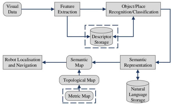
In general, a traditional visual based semantic mapping system consists of three parts. At first, the specific features are pre-selected based on sensor type, and feature descriptors are computed and obtained. Subsequently, features or descriptors are classified in terms of prior knowledge so that objects and places can be recognized. Finally, properties are endowed with semantic meanings on the basis of topological and metric maps. Figure 2.3 presents the gen-eral process for semantic mapping. Note that a metric map is considered as a complementary attribute of a semantic map. In addition, some systems rely on direct image segmentation to obtain semantic information rather than using feature descriptors to represent objects or scenes. Many types of visual sensors have been developed to provide a variety of interpretations of the world. In addition, the subsequent processing methods are highly dependent on the data type used. To some extent, the visual sensor applied plays a key role in a semantic mapping system. The visual sensors used for robot mapping include conventional monocular cameras,
14 2.1. INTRODUCTION Visual Data Feature Extraction Object/Place Recognition/Classification Semantic Representation Semantic Map Topological Map Metric Map Natural Language Storage Descriptor Storage Robot Localisation and Navigation
Figure 2.3: Overview of the general process for semantic mapping.
omni-directional cameras, stereo cameras and RGB-D cameras. At first, visually recognizing objects or places was normally done by using conventional cameras that record two dimensional images. In recent years, extracting semantic information from 3D point clouds has become a new trend due to the availability of low-cost and light-weighted 3D point cloud capturing de-vices such as stereo cameras and RGB-D sensors, which allow the application to small robot platforms or even wearable devices easily. Compared with 2D images, 3D point clouds over-come the limitation in the data-stream itself by providing additional depth data. Moreover, humans recognize and perceive a 3D world in terms of our eyes. Therefore, object recognition through capturing 2D projections of the 3D world is inevitably inaccurate and might be even misleadingly suggested, especially when it comes to a large variety of goods in our daily life [34].
The rest of this section is organized as follows. In Section 2.2, visual feature extraction methodologies are outlined and classified in terms of global and local features. Section 2.3 describes three basic recognition approaches in semantic mapping, namely global, local and hybrid approaches. More direct deep learning based approaches developed in recent years are given in this section. Subsequently, how to generate semantic representations of the environ-ment is outlined in Section 2.4 and some typical real-world applications are presented in Section
2.5. Finally, a brief conclusion and discussion are given in Section 2.6.
2.2
Visual Features Used in Semantic Mapping Systems
In the last decade, some researchers have reported systems in which semantic interpretation of certain scenes were obtained [35, 36]. However, the acquisition was done through conver-sations between humans and robots or even hand-coded into the systems rather than using the robots’ own sensors [37]. Visual features describe the elementary characteristics such as shapes, colours, textures, motions and relations between pixels in raw visual data and can be broadly divided into two categories: global and local features [38].
Global features represent an image as a whole without directly describing the spatial layout of the properties in the image. More specifically, the statistics of all the pixels in a movable fixed-size bounding box are extracted to generate feature vectors which can determine the like-lihood for image matches. Such features are suitable for large scale environment recognition, e.g. roads, lawns in outdoor environments and rooms in buildings. However, global features are sensitive to cluttered background and occlusion due to their essential attributes. Therefore, their performance drops relatively in the case of object recognition in indoor environments where direct specification of the content in an image is required or when an object is not enclosed by the bounding box. Local features on the other hand rely on individual pixels or discrete regions. Typically, salient features of highly textured objects are extracted by feature detectors and rep-resented by compendious feature descriptors. The representation of the content in an image is thus more robust to scale, viewpoint or illumination changes.
2.2.1
Global Features
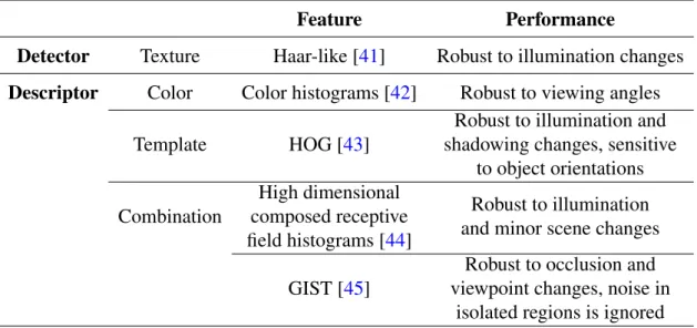
Despite the limitation of global features, they are still useful in cases where a rough place or object classification is required. Global features consist of the statistics extracted from a whole image or a bounding box, such as contour, shape, texture, colour or a combination of them [39]. They generally represent an image with a single high-dimensional feature vector, and thus can be easily applied with any standard classification methods [40]. Moreover, thanks to the compact representation and low computational cost, they have been employed by some semantic mapping systems in real-time. Table 2.1 presents the differences and similarities of the global features used for object recognition in semantic mapping systems.
16 2.2. VISUAL FEATURES USED IN SEMANTIC MAPPING SYSTEMS Table 2.1: Global features for object recognition in semantic mapping systems.
Feature Performance
Detector Texture Haar-like [41] Robust to illumination changes Descriptor Color Color histograms [42] Robust to viewing angles
Template HOG [43]
Robust to illumination and shadowing changes, sensitive
to object orientations Combination High dimensional composed receptive field histograms [44] Robust to illumination and minor scene changes
GIST [45]
Robust to occlusion and viewpoint changes, noise in
isolated regions is ignored
Inspired by the application of Haar-like feature in human face detection [41], a small number of objects were first recognized as landmarks in [46]. The recognized objects were then applied as supplementaries to the geometrical features in order to distinguish rooms that had similar geometrical structure and could only be further identified by the objects found there. The Haar wavelets presents the average intensity differences between regions, and likewise can be used to compare the differences between the sum of pixel values in bounding boxes, which allows relatively high robustness to illumination changes.
Ulrich and Nourbakhshthus implemented colour histograms for place recognition by com-paring query images with limited images of an entire dataset [47]. Applying colour histograms for image matching was first conducted by Swain and Ballard [42]. The number of colour histograms is based on the number of the colour bands used, e.g. red, green and blue. Each histogram is built by simply counting the number of pixels with a specific intensity in different colour bands. Such feature is robust to viewing angle changes in the case when properties in the environment remain fixed. Furthermore, it provides a highly compact representation of an im-age and thus requires less memory space. However, it fails to describe spatial relations, which limits its applicability. Filliatet al. also adopted this feature to discriminate identical chairs of different colours [48].
Spatial information such as feature location was not included by the holistic methods pre-sented above due to the lack of a segmentation step. Some features divide an image into small discrete regions and then one can compute the global statistics within individual regions in
or-der to obtain some rough spatial information. Grimmettet al. used the Histogram of Oriented Gradient descriptor (HOG) [43] to represent training data in order to detect parking space [49]. HOG describes objects by concatenating histograms of the gradient directions computed from the pixels within individual regions divided from an image, called cells. Each histogram is then contrast-normalized across a group of cells, called a block, to decrease the susceptibility to illumination or shadowing changes, except for object orientations. Such feature has a high performance for pedestrian detection if they maintain a roughly upright position.
Global features have also been combined in some systems to provide richer representations of the environment. A high dimensional composed receptive field histogram was applied in [44], which consists of normalized Gaussian derivatives, differential invariants and chromatic cues. Siagianet al. attempted to incorporate context using the GIST descriptor [45] for scene classification [50, 51]. Orientation, colour and intensity channels are employed by GIST to filter input images with Gabor filters at multiple spatial scales to extract the gist of images. Hinterstoisseret al. presented another 3D feature as a complement for DOT feature, named LINE-MOD, by computing object surface normal with a depth sensor [52]. These methods tend to be relatively more robust than using a single global feature since the random noise produced by individual features can be averaged out.
2.2.2
Local Features
Local features that are widely used in semantic mapping systems for object and place recogni-tion can be further divided into three categories: edge, corner and blob based approaches [53]. Figure 2.4 shows the definition of local visual features in computer vision. An edge is a set of pixels with strong gradient magnitudes or located where the image intensities change sharply. This normally refers to the boundaries between distinguishable regions. A corner is a pixel at which two edges intersect or has edges with two or more directions in the neighborhood. The term corner is additionally used in some cases which differ from our common sense, e.g. a small white spot (corner) on black background, since apart from relying on explicit edge detec-tion, a corner can also be computed from the curvature in image gradient. A blob is a group of connected pixels with similar characteristics. It refers to an interest point as well because many interest point detection methods are essentially based on corner detection at multiple scales.
differ-18 2.2. VISUAL FEATURES USED IN SEMANTIC MAPPING SYSTEMS
(a) Original image. (b) Edge.
(c) Corner. (d) Blob.
Figure 2.4: Definition of local visual features in computer vision.
ences and similarities of the local features used for object recognition in semantic mapping systems.
Edge Based Approaches
The primary characteristic of edges in an image is the sharp change, which is commonly used and captured by classical differentiation based edge detectors. Currently, such edge de-tectors are only used to generate fundamental cues to construct more robust features or provide complementary information for semantic mapping systems [67]. Ranganathan and Dellaert
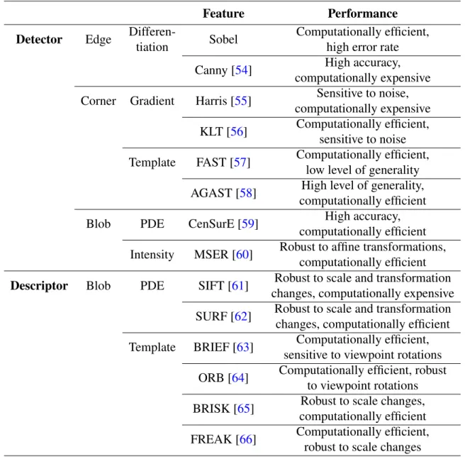
Table 2.2: Local features for object recognition in semantic mapping systems.
Feature Performance
Detector Edge
Differen-tiation Sobel
Computationally efficient, high error rate
Canny [54] High accuracy,
computationally expensive Corner Gradient Harris [55] Sensitive to noise,
computationally expensive KLT [56] Computationally efficient,
sensitive to noise Template FAST [57] Computationally efficient,
low level of generality AGAST [58] High level of generality,
computationally efficient
Blob PDE CenSurE [59] High accuracy,
computationally efficient Intensity MSER [60] Robust to affine transformations,
computationally efficient Descriptor Blob PDE SIFT [61] Robust to scale and transformation
changes, computationally expensive SURF [62] Robust to scale and transformation
changes, computationally efficient Template BRIEF [63] Computationally efficient,
sensitive to viewpoint rotations ORB [64] Computationally efficient, robust
to viewpoint rotations BRISK [65] Robust to scale changes,
computationally efficient FREAK [66] Computationally efficient,
robust to scale changes
[68] converted each training image to a set of regions of interest with Canny edge detector [54]. Clustered edges were obtained to facilitate modelling texture-less objects like desks. The Canny edge detector sets three general criteria for edge detection: low error rate, precise localization on the centre of edges and a given edge in an image should only be marked once. Owing to these criteria, it is one of the most strictly defined methods that provides robust and reliable edge detection. Wuet al. attempted to filter each input image with Sobel operator beforehand since they were interested in the spatial structure property of an image rather than detailed textural information [25].
20 2.2. VISUAL FEATURES USED IN SEMANTIC MAPPING SYSTEMS which is quite similar to object segmentation, named boundary detection. Boundary detection considers an object as a whole. It suppresses the internal edges extracted from the textures within objects and only presents the edges between objects and background. Multiple low-level features are combined to detect boundaries based on machine learning algorithms. However, simply using 2D images tend to be computationally more expensive or less reliable than apply-ing an additional depth channel for them, since it is relatively straightforward to obtain object boundaries from a 3D image. Thus boundary detection using only 2D images is rarely imple-mented in semantic mapping.
Corner Based Approaches
Primitive corner based approaches rely on gradient assessment, which is a theoretical con-cept abstracted from our common sense understanding for the term corner. In [68, 69], Harris corner detector [55] was used to facilitate training a database and compute the differential of au-tocorrelation according to directions directly. A similar detector named Kanade-Lucas-Tomasi (KLT) [56] was employed in [70] for efficient and continuous tracking. Compared to Harris detector, KLT has an additional greedy corner selection criterion, thus is computationally more efficient. However, these corner detectors are not reliable in all circumstances during semantic mapping since gradient assessment method is highly sensitive to noise.
In order to decrease the complexity of gradient assessment and increase computational effi-ciency, some methods based on template have been implemented. Such features extract corners by comparing the intensity of a pixel with other pixels in the local neighborhood, i.e. a pre-defined template. Henryet al. [71] and Gálvez-Lópezet al. [72] attempted to apply Features from Accelerated Segment Test (FAST) [57] for indoor mapping and loop closure, respectively. Based on machine learning algorithms, FAST yields a large speed increase, thus is widely em-ployed by real-time systems. FAST uses a circular template of 16 pixels to evaluate whether a candidate pixel is actually a corner. The candidate pixel is classified as a corner in cases when a certain number of contiguous pixels in the circle are all brighter than the intensity of the can-didate pixel plus a threshold value or all darker than the intensity of the cancan-didate pixel minus a threshold value. During the high-speed test for rejecting non-corner points, a decision tree is applied to address the correct rules of the chosen detector. However, FAST suffers from a low
level of generality, since it has to be trained for specific scenes before applied. FAST-ER [73] and Adaptive and Generic Accelerated Segment Test (AGAST) [58] increase the performance of FAST in terms of repeatability and generality, by widening the thickness of the Bresenham’s circle and training a set of decision trees rather than relying on one tree, respectively.
Blob Based Approaches
Blob based approaches rely on identifying the unique regions in an image by comparing local properties (e.g. intensity and colour) to their neighboring regions. In a blob, specific properties of all the points remain constant or approximately constant, i.e. to some extent, the points are similar to each other. Blob based approaches can be further divided into two categories: keypoint and interest region based approaches. Keypoint based approaches are focused on finding local extrema in scale spaces, whereas interest region based approaches aim at segmenting regions. A scale space is a representation of gradually smoothed images obtained by the rules that can describe basic properties of interest. The scale space presents an image with an additional third dimension. Note that a corner can also be regarded as a keypoint at a specific scale.
Classical interest point based methods are based on Partial Differential Equations (PDE), among which the Laplacian of Gaussian (LoG) is one of most widely used methods. An input image is first convolved by a Gaussian function at a certain scale to represent the image in a Gaussian scale space. The Laplace operator is then applied to obtain strong responses for bright and dark blobs. Compared with LoG, the Difference of Gaussians (DoG) computes the Laplacian of Gaussian operator by the difference between two continuous images smoothed by Gaussian function. DoG can also be viewed as an approximation of the Laplacian operator, thus is computationally more efficient. A hybrid blob detector Hessian-Laplacian combining the Laplacian with the Determinant of the Hessian (DoH) blob detectors has also been proposed, where spatial selection is done by the determinant of the Hessian matrix and scale selection is performed with the scale-normalized Laplacian.
Based on DoG and Hessian matrix, Lowe proposed Scale Invariant Feature Transform (SIFT) [61], which was widely applied by robot SLAM and object recognition systems [29,
22 2.2. VISUAL FEATURES USED IN SEMANTIC MAPPING SYSTEMS that are invariant to scale and orientation changes. The points selected from the training image which usually lie on high-contrast regions of images such as edges and corners are detectable even under changes in image scale, noise and illumination. Another property of these points is that the relative positions between them in the original image remain stable from one image to another. Subsequently, low contrast and unstable points are rejected based on their locations and scales. Orientations are then assigned to the points based on gradient directions, thus pro-viding invariance to transformations. Finally, SIFT computes a descriptor vector (histogram of oriented gradient) as a representation for each keypoint. Compared with other feature de-scriptors, SIFT is highly robust to scale and transformation changes, but is computationally expensive. A refinement of SIFT was proposed by Mikolajczyk and Schmid named Gradient Location and Orientation Histogram (GLOH) [77], which proves to be more distinctive than SIFT, yet requires even more computational cost.
Riazueloet al.initially extracted Speeded Up Robust Features (SURF) from each image and stored them for latter object recognition in the RoboEarth database, which is a knowledge-based system providing web and cloud services [78]. SURF has claimed to be several times faster than SIFT and its accuracy remains relatively acceptable. SURF employs integral images and uses square-shaped filters to approximate the determinant of Hessian matrix during Gaussian smoothing, thus is more computational efficient. Morissetet al.used Centre Surround Extrema (CenSurE) [59] to obtain a visual odometer in real-time [79]. CenSurE is another approximation of LoG. Compared with SIFT and SURF, CenSurE features are evaluated for all the pixels across all scales in raw images. This leads to higher accuracy. Moreover, even seeking extrema at all scales, it still maintains a relatively low computational cost by adopting a set of simple centre-surround filters. Implementations of these refinements in semantic mapping systems can also be found in [48,80,81].
Due to the high demand for real-time applications, Gálvez-López and Tardós adopted Bi-nary Robust Independent Elementary Features (BRIEF) [63] to find the best frame-to-frame matches for real-time localization over long periods [72]. BRIEF is a binary string constructed by classifying image patches according to pairwise intensity comparisons, which leads to a small memory usage and is highly computational efficient during recognition.
Inspired by FAST and BRIEF corner detector based on template, Rublee et al. presented Oriented FAST and Rotated BRIEF (ORB) by estimating the patch orientation [64], thus is
invariant to viewpoint rotations. The scale pyramid is also applied to increase its robustness to scale changes. Such method was employed in [82] to generate photometric feature for RGB-D mapping. Grimmettet al. used Binary Robust Invariant Scalable Keypoints (BRISK) [65] to build maps for automated parking [49]. BRISK applies AGAST detector in both image plane and scale space to classify keypoints so that it is invariant to scale changes. A keypoint detector motivated by human retina and derived from BRISK was presented by Alahiet al. [66], named Fast Retina Keypoint (FREAK), which was applied in [83] for facial point detection and emotion recognition. Compared to BRISK, FREAK has a higher density of points near the centre of the sampling grid.
Megeret al. [74] and Sunet al. [84] applied Maximally Stable Extremal Region (MSER) [60] in their systems to provide object location information for an attentive system and to ex-tract lane marking features, respectively. MSER is one of the most widely used methods for interest region detection. It is robust to affine transformations and is highly computationally efficient. However, it is sensitive to image blurry changes. Moreover, MSER is a region de-tector in essence, thus is only suitable to distinguish objects with little variation in colour from high-contrast scenes.
Discussion
One of the most important factors in evaluating the feature detectors and descriptors imple-mented in semantic mapping systems is their accuracy (reliability). To assess it, a repeatability criterion presented by Schmidet al. measures whether or not the same feature is detected in two or more different images of the same scene under varying viewing conditions [85]. The repeatability is a ratio between the accurate pairing number and the minimum number of key-points detected in the given images. The repeatability of some local features is shown in [38]. Three image transformations are considered: zoom factor, viewpoint and rotation.
With respect to some SLAM or object recognition systems running in real-time, the com-putational complexity of the applied feature detectors also plays a key role. Canclini et al.
[38] also evaluated the efficiency of some widely used keypoint detectors in semantic mapping systems. More specifically, the average processing time was assessed based on the number of keypoints detected. FAST and AGAST are computationally more efficient than other detectors.
24 2.3. RECOGNITION APPROACHES Another noticeable difference is that the processing time of CenSurE and ORB remains con-stant, whereas with the increase of the keypoint number, the processing time of other detectors grows linearly. The influence of image scale changes on the detectors was also presented. The processing time for all the detectors raises as a quadratic function with the increase of image scale. Again, SIFT and SURF are several times more time-consuming.
2.3
Recognition Approaches
This section presents some basic object/place recognition approaches in semantic mapping sys-tems, namely global, local and hybrid approaches [86]. Object recognition methods based on global features are classified into global approaches. Such approaches also consist of some place recognition methods which employ image segmentation algorithms directly rather than referring to the properties in the environment. Local approaches include pixel-wise operations on the basis of local feature extraction and the straightforward sampling of pixel contributions. Some systems combine global approaches with local approaches to achieve a more robust per-formance, which is discussed in hybrid approaches. In addition, information that is retrieved to distinguish individual instances within an object class (e.g. shampoo or conditioner, someone’s office) is also discussed. We finally summarizes some recent deep learning based approaches.
2.3.1
Global Approaches
Based on the global statistic features retrieved from texture, Hidden Markov Model (HMM) was applied in [87] for place recognition and new place categorization. For HMM, the states which represent different locations are not directly visible, whereas the output acquired from the states is visible. Compared by using a uniform transition matrix, HMM provides a significant increase in recognition performance. Furthermore, the computational cost is quite low and can be neglected during mapping. However, it is only applicable for a small database. Mozoset al. implemented a cascade of classifiers [88] which depended on boosting to detect 8 different objects in order to recognize 6 places [46]. Boosting is a supervised learning-based method combing several simple weak classifiers to achieve a relatively high performance. For each of the weak classifiers used, the requirement is that its accuracy should be better than random guessing. The accuracy of the weak classifiers leads to their distributions once they are added. The cascade of classifiers is essentially a degenerated decision tree which rejects non-object
regions at each stage and retains interest regions for further classification. Although the training time is long, the prediction can be run in real-time. Gentle AdaBoost was also applied by Murphyet al.for object and scene recognition [45].
In the case of colour histogram features, Ulrich and Nourbakhsh used a simple unanimous voting scheme to classify places [47]. The input images were voted by each colour band with the smallest minimum matching distance. A certain place was classified when the colour bands unanimously voted for the same place and the total confidence was above a threshold. Such a method is quite straightforward and computationally efficient. However, one important prereq-uisite is that the visible properties in scenes should remain relatively fixed and its performance drops when it comes to a large database (over 100 images).
Support Vector Networks (SVM) [89] was applied with HOG feature by Dalal and Triggs [43]. SVM is a set of supervised models with associated learning algorithms widely used for data analysis and pattern recognition. The training process tries to build a model by the given examples to assign new examples into two categories, making it a non-probabilistic binary linear classifier. This step is essentially a process to find a model with high performance, i.e. a clear gap that is as wide as possible. In [43], positive examples (images which contained pedestrians) and negative examples (person-free images) were provided for SVM training. The implementation of linear SVM rather than using a kernel decreased the computational cost of the system. Pronobiset al. also applied SVM to recognize places [44] based on a kernel [90], which proved to achieve better performance for histogram-like features. Results in this paper showed that the places were recognized with high precision and robustness even when training on images from one camera device and testing on another. Inspired by Taylor and Drummond [91], the Streaming SIMD Extensions (SSE) were applied to efficiently compute error functions [92].
2.3.2
Local Approaches
Apart from the approaches mentioned above, one of the most promising works has been done by Lowe [61]. Once the SIFT features are detected and described, recognizing objects becomes a problem of finding groups of similar descriptions that have all undergone the same transfor-mation. More specifically, an interest point in the test image is compared to an interest point in the reference image by the differences between their description vectors, which is based on
26 2.3. RECOGNITION APPROACHES Euclidean distance. For rapid computation against large databases, the features are put in a KD-tree, which is a data structure based on nearest neighbor searching for large databases. The Hough transform is used to cluster the features that belong to the same object. Clusters of at least 3 features that agree on the object and its pose are identified as candidate matches. A least-square approximation is then made to obtain the best estimated affine projection param-eters, which are further applied to decide whether to keep or reject the matches. This method has been widely implemented in robot semantic mapping systems [75,74,29] thanks to its high robustness. However, due to the complexity of the SIFT feature, the recognition process still suffers from high computational cost.
In the case of the binary features inspired by modern computer architectures, such as BRIEF, BRISK, ORB and FREAK, the Hamming distance is used for matching. The Hamming distance between two feature vectors is the number of positions at which the corresponding symbols are different. Such matching method is highly computationally efficient. However, the accuracy is lower than the method presented by Lowe.
2.3.3
Hybrid Approaches
Some systems adopted global features, local features and depth information to generate a more robust recognition performance. Depth information additionally provides spatial dimensions of objects and represents objects in more detail, thus leads to a higher recognition accuracy compared to using solely 2D features. Histograms of Oriented Energy and colour were directly applied for object detection in [93]. Stückleret al.employed region features in both colour and depth space and applied object-class segmentation algorithms for semantic mapping [94], based on Random decision Forests (RFs), which is an ensemble learning method for classification and has been demonstrated to achieve comparable performance to SVM [95]. In this work, a subset of images from the training set was randomly selected as a sample to train the decision trees. Small objects were better sampled for training, thus the actual individual distributions of class labels were reassigned according to this. One advantage of RFs is the high computational efficiency during outputting, yet the training time is still relatively long.
Filliat [96] and Martínez-Gómezet al.[97] employed a Bag of Binary Words (BoW) model [98] to incrementally learn to recognize different rooms from any robot position. BoW is in-spired by a technique in document classification and consists of two phases, namely
representa-tion (indexing) and recognirepresenta-tion (retrieval). Image features that are robust to intensity, rotarepresenta-tion, scale and affine are detected and described by independent feature descriptors with vectors, such as SURF and FAST (SIFT, colour histograms and normalized gray level histogram in this paper). Subsequently, the vectors are clustered by vector quantization algorithms, e.g. K-means clustering [99]. The predefined codewords (words in documents) are then assigned to the clus-ters to generate a codebook (a word dictionary), thus the images are represented by a histogram of codewords. In the case of the recognition stage, generative or discriminative models such as Naive Bayes classifier, SVM and AdaBoost are applied as the classifiers. Such a method is quite flexible in terms of both applicable features and recognition approaches. However, the spatial relationships among the clusters are ignored when BoW is used alone, which has been compensated by Lazebniket al. [18].
Text or signs can provide location information directly. Most text recognition systems im-plemented Optical Character Recognition (OCR) for classification [100,101,102], which is an off-the-shelf technology to convert images of typed, handwritten or printed text into machine-encoded text. Sami et al. [101] adopted a back-projection of the colour histogram to locate interest regions and applied Canny edge detector to remove background. A pan/tilt/zoom cam-era was used in [102] to provide better focusing performance on potential text regions in the wild. However, text retrieval still suffers from low performance in cluttered environments, which limits its practicability.
2.3.4
Deep Learning Based Approaches
Convolutional Neural Networks (CNNs) have recently been widely used as robust visual fea-ture extractors in the computer vision and machine learning domain and have shown better performance in terms of changing environments, viewpoints, lighting conditions, objects, etc. [103, 104]. Sharif Razavian et al. [104] have shown that CNNs outperform BoW in most recognition tasks in terms of large datasets.
Although most CNNs are trained for object recognition, some researchers have managed to modify these models for other related but different tasks such as place recognition and object detection [104, 105, 106] since the generic features learned by different models from holistic images in different datasets are versatile and transferable [107,108].
28 2.4. SEMANTIC REPRESENTATION for training also benefit visual odometry. PoseNet proposed by Kendall et al. [109] shows the first implementation on pose estimation, which directly generates the six degrees of freedom (6-DoF) of an camera from a single RGB input image. The model GoogLeNet [110] pre-trained on other classification tasks is leveraged for pose regression. The softmax layers that originally output classification results are removed and replaced by a seven dimensional pose vector. The last fully connected layers are also modified. CNNs extract more robust features than traditional feature detectors and achieve high accuracy even when extreme conditions exist, such as intense lighting and blurry images. PoseNet can also be easily generalized to other scenes through transfer learning technique. The model on the new task can thus be trained with smaller dataset and shorter time. Liet al. [111] incorporated another CNN stream to PoseNet and fed depth images into this stream to enhance the relocalization accuracy. ORB-SLAM is used to label the collected images as ground truth. Recurrent Convolutional Neural Networks [112] were also employed by Wanget al.[113] for pose estimation. However, all of these deep learning based methods require ground truth poses for training, which can be quite expensive and labour-intensive to produce.
2.4
Semantic Representation
Semantic representation is the interpretation process from objects or places to a human-compatible or even human-like language. Some systems presented above apply classification or segmen-tation methods for the purpose of recognizing specific objects or scenes, thus the semantic information is directly obtained. In this section, we mainly focus on the semantic information inferred by robots.
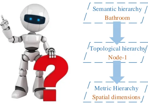
Early systems [37, 29] adopted the idea that a semantic map consists of two separate but tightly interconnected parts: a spatial part and a terminological part [114]. This is a typical structure of hybrid Knowledge Representation (KR) systems [115], as shown in Figure 2.5. The spatial part contains raw images from the sensors, geometric information of the environ-ment and connectivity between the rooms, whereas the terminological part consists of general semantic knowledge about the environment, giving meanings to the features of the correspond-ing properties in the environment in terms of general concepts and relations. These two hierar-chies are interrelated by the concept of anchoring [116]. In [37], the NeoClassic AI language was employed to establish the conceptual hierarchy and provided the robot with inference
![Figure 2.1: Metric map [1].](https://thumb-us.123doks.com/thumbv2/123dok_us/9057719.2803873/34.892.89.751.148.617/figure-metric-map.webp)
![Figure 2.6: The final semantic map obtained by Pronobis et al. [3]](https://thumb-us.123doks.com/thumbv2/123dok_us/9057719.2803873/53.892.244.692.123.1063/figure-final-semantic-map-obtained-pronobis-et-al.webp)
![Figure 2.8: Interaction between the robot and the kitchen facilities [4].](https://thumb-us.123doks.com/thumbv2/123dok_us/9057719.2803873/55.892.132.809.130.576/figure-interaction-robot-kitchen-facilities.webp)