Volume 8, No
.
5, May – June 2017International Journal of Advanced Research in Computer Science RESEARCH PAPER
Available Online at www
.
ijarcs.
infoSatellite Image Classification using Firefly Algorithm to Identify Natural Terrain
Features
Paramjit Kaur
Research Scholar, Department of Computer Science, Rayat Institute of Engineering and Information Technology
Railmajra, Punjab, India
Harish Kundra
Head and Professor, Department of Computer Science, Rayat Institute of Engineering and Information Technology
Railmajra, Punjab, India
Abstract: In the recent years, swarm intelligence based firefly algorithm has become a great focus for the researchers to solve the real time optimization problems
.
Here, firefly algorithm is used for the application of satellite image classification.
For experimentation, Alwar area is considered to multiple land features like vegetation, barren, hilly, residential and water surface.
Alwar dataset is considered with seven band satellite images.
Firefly Algorithm is based on the attraction of less bright fireflies towards more brightener one.
For the evaluation of proposed concept accuracy assessment parameters are calculated using error matrix.
With the help of Error matrix, parameters of Kappa Coefficient, Overall Accuracy and feature wise accuracy parameters of user’s accuracy & producer’s accuracy can be calculated.
Overall results are compared with BBO, PSO, Hybrid FPAB/BBO, Hybrid ACO/SOFM and Hybrid ACO/BBO based on the kappa coefficient and overall accuracy parameters.
Keywords: Image Classification, Firefly Algorithm, Satellite Data, Terrain Feature Identification, Swarm Intelligence
I. INTRODUCTION
Swarm Intelligence is an artificial concept inspired from the collaborative multiagent social species that work intellectually to design intelligent system and optimized algorithm [1]
.
These social species can be small ants, termites, wasp, bee, flying birds, school of fishes and other animal groups also.
The first use of term “swarm” was made by Beni during cellular robotic system in which agents organizes them with nearest neighbour interaction [2].
After that it is being used for the various optimization area like science, industry etc.
There is a great importance for the solution of optimization problems both in the field of science and industry.
The global cooperation of these social species to work collaboratively is due to strategy of self organization.
Self organization is a dynamic strategy where agents create global system by interaction of local level components
.
Some of the popular swarm intelligence techniques are listed Bat Algorithm, Ant Colony Optimization, Cuckoo Search, Firefly Algorithm, Intelligent Water Drops Algorithm, Biogeography Based Optimization, Particle Swarm Optimization and Artificial Bee Colony Optimization [3].
From the above techniques, we are using firefly algorithm due to its behaviour to find the global solution in short time constraint.
Remote Sensing is the method to get information about any far object without any kind of contact with that [4]
.
Remote sensing involves the steps to sense the object, record their emitted energy, process that energy and finally analysing thatfor the information of object
.
Generally, remote sensing concept is considered to sense the objects of earth surface using satellites.
Remote Sensing involves a wide spectrum of sensing process
.
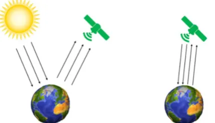
Based on the sensing elements, remote sensing can be categorized into two types as below [5] [6]:Active Remote Sensing and Passive Remote Sensing Passive Remote Sensing can be defined as the sensing process that have the need of external energy sources like sun to illuminate the target (as shown in figure 1a)
.
The sensors that can sense the target with the help of external natural illuminists are known as Passive Sensors.
Active Sensing can be defined as the sensing process with the help of Active sensors that can afford their own sources of energy for illumination (as shown in figure 1b)
.
In Active Sensing, no any external source of energy is required.
The sensing process works directly from sensors to target object and the reflected radiations are measured by the sensors after detection of target.
In this experimentation, dataset of Alwar region is considered having land cover attributes of Barren, Rocky, Vegetation, Urban and Water [7]
.
Figure 1: (a) Passive Remote Sensing (b) Active Remote Sensing
[image:1.595.310.525.605.727.2]firefly algorithm on the basis of available attributes
.
Further, results are assessed in terms of error matrix.
Error matrix presents the comparison parameters of kappa coefficient, user’s accuracy, producer’s accuracy and overall accuracy.
Rest sections of paper are discussed here: Section II presents the basic concepts Firefly Algorithm
.
Section III presents the information about considered dataset.
Section IV explains the proposed firefly algorithm for satellite image classification; Section V presents the comparative results and evaluation of concept.
Section VI concludes the paper.
II. FIREFLY ALGORITHM
Firefly algorithm is swarm intelligence based metaheuristic algorithm introduced by Xin-She Yang by taking the inspiration from the biological lighting behavior of social species firefly [8]
.
There is the existence of thousand of firefly species in the world and all these species are produce some rhythmic light flashes.
Each firefly species follows some different pattern of flashes by using the bioluminescence process.
There are some fundamental aspects behind this flashing of firefly species like protective warning mechanism, mating process and potential to attract prey.
The objective function of this firefly algorithm is formulated in association with flashing light behaviour.
Firefly algorithm mainly depends upon three idealized rules as mentioned below [9].
1. One firefly attracts other apart from of their sex as all the considered fireflies are assumed as of unisex feature
.
2. Fireflies attract each other depending upon their brightness
.
Brightness value is proportional to attractiveness.
So, brighter firefly attracts the lesser brighter firefly.
In case there is no possibility of brighter one, then fireflies move randomly.
3. Landscape of objective function is considered to determine the brightness of firefly algorithm
.
In firefly algorithm, objective function is used to represent it in mathematical form and to draw some formulation to find the optimized solution of the problems
.
The pseudo code for the firefly algorithm is given below in figure 2.
Objective function f(x), x =(x1,
...
sd)Generate initial population of fireflies x
T
i
Light intensity I
(i=1,2,
...
,n)i at xi is determined by f(xi
Define light absorption co efficient γ )
While (t<MaxGeneration) for i =1: n all n fireflies for j = 1: i all n fireflies if (Ij > Ii
Attractiveness varies with distance r via exp[-yr] ), Move firefly i towards j in d-dimension; end if
Evaluate new solutions and update light intensity end for j
end for i
Rank the fireflies and find the current best end while
Postprocess result and visualization
Figure 2: Pseudo Code of Firefly Algorithm
III. DATASET CONSIDERED
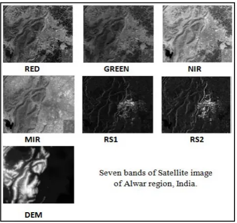
Satellite based image classification is performed on the Alwar region situated in Rajasthan State, India
.
This place is [image:2.595.307.549.89.316.2]geographically situated at longitude of 76º31’ East and Latitude of 27 º34’ North, at an elevation of 270 meters from the earth surface
.
Figure 3: Seven band satellite images of Alwar Region The reason for the selection of this Alwar region is the availability of various terrain features including water area, urbanization, rocky area, barren and vegetation etc
.
Satellite data is considered in the form of seven bands as shown in figure 3.
IV. PROPOSED ALGORITHM
In this section, proposed concept of Firefly Algorithm is explained for the identification of natural terrain features
.
The main goal to use the swarm intelligence based multi agent firefly algorithm is to obtain the optimized results for the identification of natural land cover features.
In this methodology the expert dataset of Alwar region is divided into training and testing portion.
The dataset portion selected for training purpose is considered for the classification using firefly algorithm.
The other dataset portion is used for the evaluation of proposed firefly algorithm.
The explained concept of firefly algorithm for satellite image classification is given below.
Input: Expert satellite dataset of Alwar region (Seven Band Images with their respective coordinate values)
Output: Classified Image
.
Algorithm
Step 1: Initially, seven band satellite images are considered as the input for the image classification where fireflies are assumed as the pixels of the image
.
Step 2: The overall objective of this firefly algorithm in image classification is to find the best match for image pixels to classify them as per their feature class
.
Step 3: Firefly works on the fundament to attract other firefly
.
𝐼𝐼 ∝ 1⁄𝑟𝑟2
…Equation (1) Where, I is the intensity value and r is the distance
.
Step 4: To evaluate the distance between the two firefly i and j, apply the Cartesian distance formula as shown in equation (2)
.
𝑟𝑟𝑖𝑖𝑖𝑖 =�(𝑥𝑥𝑖𝑖− 𝑥𝑥𝑖𝑖)2+ (𝑦𝑦𝑖𝑖− 𝑦𝑦𝑖𝑖)2
…Equation (2)
Where, rij
Step 5: Calculate the attractiveness value for each pixel (firefly) of the image using the objective function below as shown in equation (3)
.
𝛽𝛽= 1 +𝛽𝛽0𝛾𝛾𝑟𝑟2
is the distance between i and j firefly, and x, y are the coordinates
.
…Equation (3) Where, β is the attractiveness, β0
Step 6: Find the best possible solution for each pixel based on their attractiveness factor
.
Store the best solution as per their brightness level for each pixel.
is the attractiveness at distance r = 0 and γ is the light absorption coefficient
.
Step 7: Evaluate the overall best solution by evaluating the Pearson Correlation Coefficient for the found solution for each pixel using formula given in equation 4
.
𝑟𝑟= ∑𝑛𝑛𝑖𝑖=1(𝑋𝑋𝑖𝑖− 𝑋𝑋�)(𝑌𝑌𝑖𝑖− 𝑌𝑌�) �∑𝑛𝑛𝑖𝑖=1(𝑋𝑋𝑖𝑖− 𝑋𝑋�)2�∑𝑖𝑖𝑛𝑛=1(𝑌𝑌𝑖𝑖 − 𝑌𝑌�)2
…Equation (4)
More the value of correlation, the solution will be more efficient
.
Step 8: As per the best solution, assign the best solution class to the pixel as per terrain features
.
Step 9: Repeat the steps III to V until all the pixels classified
.
Step 10: Obtain the Classified Image
.
V. RESULTS AND DISCUSSION
A. Results
The proposed concept is implemented on MATLAB simulation software
.
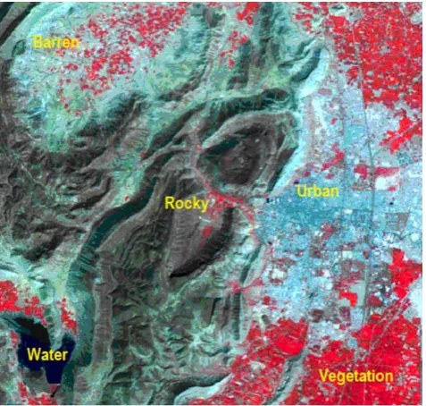
The input image considered for image classification is shown in figure 4 (Image is obtained by stacking seven band satellite images).
For the classification of Alwar region based land, firefly algorithm is used.
The classified image using firefly algorithm is shown in figure 5.
The proposed concept classifies the image by considering the color specification of feature classes as water is represented by red color, vegetation is represented by yellow color, urban area is represented by cyan color, rocky area is represented by blue color, and barren is represented by white color.
[image:3.595.309.548.55.282.2]To evaluate the results of classified image, we have used the data remaining for verification purpose. The dataset experts pixels used for image classification are as Water: 55 Pixels, Vegetation: 125 Pixels, Urban: 127 Pixels, Rocky: 92 Pixels, Barren: 102 Pixels.
[image:3.595.310.557.330.547.2]Figure 4: Input Image used for classification
Figure 5: Obtained classified image using Firefly Algorithm
To observe the results of image classification using firefly algorithm, Error Matrix is evaluated
.
Error matrices describe a relationship between the absolutely classified pixels and erroneous pixels for each terrain class.
The obtained Error matrix for firefly algorithm is shown in table 1.
Error matrix provides the evaluation in the form of feature wise evaluation and complete evaluation
.
Feature wise evaluation parameters are user’s accuracy and complete evaluation methods are kappa coefficient and overall accuracy.
Table 1: Error matrix for Firefly Algorithm
Feature Rocky Water Barren Urban Vegetation Total
Rocky 80 0 4 0 0 84
Water 7 54 4 0 4 69
Barren 0 0 93 0 0 93
Vegetation 2 1 0 17 121 141
Total 92 55 102 127 125 501
User’s accuracy is an extent of how well classification is performed by row wise category
.
Producer’s Accuracy is an extent of how accurately classification is performed by the column wise category.
Feature wise user’s accuracy and producer’s accuracy are shown in table 2.
Table 2: Feature wise User’s Accuracy and Producer’s Accuracy using Firefly Algorithm
Classifier/
Feature Water Vegetation Urban Rocky Barren User’s
Accuracy 78
.
26% 85.
81% 96.
49% 95.
2% 100%Producer’s
Accuracy 98
.
18% 96.
80% 86.
61% 86.
9% 91.
17%B. Comparative Analysis
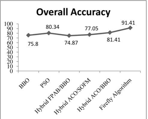
Further, firefly algorithm for image classification is compared with BBO [10], PSO [11], Hybrid FPAB/BBO, Hybrid ACO/SOFM and Hybrid ACO/BBO on the basis of kappa coefficient and overall accuracy
.
Overall Accuracy can be defined as the ratio of number of correct observations divided by the total number of classifications.
Kappa Coefficient is evaluated using the error matrix and is considered as the indirect measure of the expert’s knowledge.
[image:4.595.311.555.61.258.2]The evaluated values of firefly algorithm and other existing concepts are shown in figure 6 and figure 7
.
Figure 6: Comparison based on Overall Accuracy
Figure 7: Comparison based on Kappa Coefficient
VI. CONCLUSION
Nature being a source of inspiration has developed various new terminologies like fireflies based firefly algorithm that can be used to optimize the hard problems
.
In this research work, we have used firefly algorithm for satellite image classification of Alwar area.
Results are evaluated based on complete and feature wise evaluation with comparison with BBO, PSO, Hybrid FPAB/BBO, Hybrid ACO/SOFM and Hybrid ACO/BBO approaches.
As shown in figure 6 and figure 7, we can say that proposed concept is efficient enough to classify the land cover features.
VII. REFERENCES
[1]. Blum, Christian, and Xiaodong Li
.
"Swarm intelligence in optimization.
" InSwarm Intelligence, pp.
43-85.
Springer Berlin Heidelberg, 2008.
[2]. Beni, Gerardo, and Jing Wang
.
"Swarm intelligence in cellular robotic systems.
" In[3]. Bonabeau, Eric, Marco Dorigo, and Guy Theraulaz
.
Robots and Biological Systems: Towards aNew Bionics?, pp
.
703-712.
Springer Berlin Heidelberg, 1993.
[4]. Richards, John A
.
, and J.
A.
Richards.
Swarm intelligence: from natural to artificial systems
.
No.
1.
Oxford university press, 1999.
[5]. Lillesand, Thomas, Ralph W
.
Kiefer, and JonathanChipman
.
Remote sensing digital
image analysis
.
Vol.
3.
Berlin et al.
: Springer, 1999.
[6]. Jensen, John R
.
Remote sensing and image interpretation
.
JohnWiley & Sons, 2014
.
[7]. Goel, Lavika, Daya Gupta, and V
.
K.
Panchal.
"Hybrid bio-inspired techniques for land cover feature extraction: A remote sensing perspective.
"Applied Soft ComputingIntroductory digital image processing: a remote
sensing perspective
.
Univ.
of South Carolina, Columbus, 1986.
[8]. Yang, Xin‐She
.
"Firefly algorithm.
"12, no
.
2 (2012):832-849
.
Engineering
Optimization (2010): 221-230
.
75.8
80.34
74.87
77.05
81.41 91.41
0 10 20 30 40 50 60 70 80 90 100
Overall Accuracy
0.6881
0.7033 0.6793
0.7075 0.7636
0.8911
0 0.1 0.2 0.3 0.4 0.5 0.6 0.7 0.8 0.91
[image:4.595.37.284.422.621.2][9]. Yang, Xin-She
.
"Firefly algorithm, stochastic test functionsand design optimisation
.
" International Journal of Bio-Inspired Computation[10].Panchal, V
.
K.
, Goel, S.
, & Bhatnagar, M.
, “Biogeographybased land cover feature extraction
.
In 2, no.
2 (2010): 78-84.
Nature & Biologically Inspired Computing”
.
NaBIC 2009.
World Congress on[11].Panchal, V
.
K.
, Harish, K.
, & Jagdeep, K.
(2009).
Comparative study of particle swarm optimization based unsupervised clustering techniques.
(pp
.
1588-1591)
.
IEEE.
, 2009.
International Journal of
Computer Science and Network Security,
[12].Johal, N
.
K.
, Singh, S.
, & Kundra, H.
(2010).
A hybrid FPAB/BBO algorithm for satellite image classification.
9(10), 132-140
.
International Journal of Computer Applications
(0975–8887),
[13].Goel, S
.
, Sharma, A.
, & Panchal, V.
K.
(2011).
A Hybrid Algorithm for Satellite Image Classification.
In6(5)
.
[14].Goel, S
.
, Sharma, A.
, Bedi, P.
, & Panchal, V.
K.
(2011).
Decision Gap within Swarm in Natural Terrain Feature Identification.
Advances in
Computing, Communication and Control (pp
.
328-334).
Springer Berlin Heidelberg
.