B
Meteorologische Zeitschrift, Vol. 23, No. 3, 193–208 (published online September 19, 2014) Open Access Article © 2014 The authorsInitial phase of the Hans-Ertel Centre for Weather
Research – A virtual centre at the interface of basic and
applied weather and climate research
Martin Weissmann1,2∗, Martin Göber1,3, Cathy Hohenegger1,4, Tijana Janjic1,3, Jan Keller1,3, Christian Ohlwein1,5, Axel Seifert1,3, Silke Trömel1,5, Thorsten Ulbrich1,6, Kathrin Wapler1,3, Christoph Bollmeyer1,5and Hartwig Deneke7
1Hans-Ertel Centre for Weather Research, Germany
2Meteorologisches Institut, Ludwig-Maximilians-Universität München, Germany 3Deutscher Wetterdienst, Offenbach, Germany
4Max-Planck-Institut für Meteorologie, Hamburg, Germany 5Meteorologisches Institut, Universität Bonn, Germany 6Institut für Meteorologie, Freie Universität Berlin, Germany 7Leibniz-Institut für Troposphärenforschung, Leipzig, Germany
(Manuscript received November 30, 2013; in revised form April 30, 2014; accepted May 15, 2014) Abstract
The Hans-Ertel Centre for Weather Research is a network of German universities, research institutes and the German Weather Service (Deutscher Wetterdienst, DWD). It has been established to trigger and intensify basic research and education on weather forecasting and climate monitoring. The performed research ranges from nowcasting and short-term weather forecasting to convective-scale data assimilation, the development of parameterizations for numerical weather prediction models, climate monitoring and the communication and use of forecast information. Scientific findings from the network contribute to better understanding of the life-cycle of shallow and deep convection, representation of uncertainty in ensemble systems, effects of unresolved variability, regional climate variability, perception of forecasts and vulnerability of society. Concrete developments within the research network include dual observation-microphysics composites, satellite forward operators, tools to estimate observation impact, cloud and precipitation system tracking algorithms, large-eddy-simulations, a regional reanalysis and a probabilistic forecast test product. Within three years, the network has triggered a number of activities that include the training and education of young scientists besides the centre’s core objective of complementing DWD’s internal research with relevant basic research at universities and research institutes. The long term goal is to develop a self-sustaining research network that continues the close collaboration with DWD and the national and international research community.
Keywords: Numerical weather prediction (NWP), nowcasting, data assimilation, reanalysis, forecast
com-munication, model development
1
Introduction
The increasing vulnerability of society to weather and natural disasters emphasizes the need for improved fore-casts and warnings (IPCC, 2012). In addition, weather forecasts become increasingly important for economic applications, e.g. for predicting renewable energy pro-duction and energy demand. Climate change and its im-pact on local weather pose further risks to society and economy. The Hans-Ertel Centre for Weather Research (German: Hans-Ertel Zentrum für Wetterforschung1 ab-breviated as HErZ) initiated by Deutscher Wetterdienst (DWD) and its scientific advisory committee intends to trigger and intensify basic research in Germany that will,
∗Corresponding author: Martin Weissmann, LMU-Meteorologie,
Theresien-str. 37, 80333 München, Germany, e-mail: [email protected] 1http://www.dwd.de/ertel-zentrum
over the next decade, lead to an improved ability to pre-dict weather- and climate-related risks and to improved warnings and communication of these predictions. In a round-table discussion in 2007 that included most major German meteorological research institutions, five key research areas for the further advancement of modelling, monitoring and forecasting systems were identified:
• Atmospheric dynamics and predictability; • Data assimilation;
• Model development;
• Climate monitoring and diagnostics;
• Optimal use of information from weather forecasting and climate monitoring for society.
In the first out of three four-year phases, these topics are addressed by five branches of HErZ (Table1), which together form a virtual centre for weather and climate © 2014 The authors DOI 10.1127/0941-2948/2014/0558 Gebrüder Borntraeger Science Publishers, Stuttgart,www.borntraeger-cramer.com
Table 1: The five branches of HErZ in the initial funding phase 2011–2014. Branch topic and affiliated
authors
Project title, research topics and host institutions Branch short name
Atmospheric dynamics and predictability;
S. Trömel, K. Wapler, H. Deneke
Object-based Analysis and SEamless prediction (OASE);
• Synergistic use of multi-sensor observations
• Analysis of the structure and life-cycle of deep convection • Nowcasting and (very) short-term forecasting of severe
weather events
Universität Bonn, Leibniz-Institut für Troposphärenforschung Leipzig
Branch 1: HErZ-OASE
Data assimilation; M. Weissmann, T. Janjic
Ensemble-based convective-scale data assimilation and the use of remote sensing observations
• Methods and tools for convective-scale data assimilation • Use of cloud-related satellite observations
• Representing uncertainty in ensemble systems
Ludwig-Maximilians-Universität München
Branch 2:
Data Assimilation (HErZ-DA)
Model development; C. Hohenegger, A. Seifert
Clouds and convection
• Process studies with large-eddy simulations
• Analysis and characterization of the cloud size distribution • Improved parameterizations of subgrid processes
Max-Planck Institut für Meteorologie, Hamburg
Branch 3:
Clouds and Convection (HErZ-CC)
Climate monitoring and diagnostics;
C. Ohlwein, J. Keller, C. Bollmeyer
Retrospective analysis of regional climate;
• Development of a regional reanalysis system
• Assimilation techniques for historical observation systems • Diagnostics of the energy, water, and momentum cycles
Universität Bonn, Universität zu Köln
Branch 4: HErZ-Climate
Communication and use of forecasts and warnings; T. Ulbrich, M. Göber
Improving the process of weather warnings and extreme weather information in the chain from the meteorological forecasts to their communication for the Berlin conurbation (WEXICOM)
• Assessment of uncertainty of weather warnings • Analysis of risk communication and perception • Analysis of vulnerability and risk management
Freie Universität Berlin, Forschungsforum Öffentliche Sicherheit, Deutsches Komitee Katastrophenvorsorge
Branch 5: HErZ-Application
research. This article presents the research objectives and scientific highlights of the current implementation of HErZ after the first three years since the centre was established in the beginning of 2011.
Research in the five scientific areas of HErZ has a long history. More than 100 years after Vilhelm Bjerknes first proposed the idea of a mathematical model of the atmosphere’s dynamics (Bjerknes, 1904;
Gramelsberger, 2009) and after more than 60 years of numerical weather prediction (NWP), our ability to model the atmosphere has improved drastically (Bengtsson, 2001;Edwards, 2010). However, funda-mental advancement in our modelling capabilities re-quires time-scales of decades and therefore long-term and coordinated funding strategies. Significant short-comings still exist, particularly in our ability to ac-curately predict specific regional weather events (e.g. severe convective systems) and the regional impact of
climate change. Recent major German research ac-tivities addressed the first of these topics, particu-larly precipitation forecasts, predictability and atmo-spheric dynamics. These activities include the Prior-ity Program Quantitative Precipitation Forecast (Hense and Wulfmeyer, 2008), the field campaign Convec-tive and Orographically Induced Precipitation Study (COPS, Wulfmeyer et al., 2008) and the research group PANDOWAE2 (Predictability ANd Dynamics Of Weather Systems in the Atlantic-European Sector). HErZ builds upon expertise gained in these recent activ-ities, but has a broader focus that inter alia also includes climate research and forecasts communication.
Overall, the development of NWP systems is chal-lenging for many reasons: The complexity to combine observations with a model state for creating initial con-ditions, the requirement to include all relevant processes 2http://www.pandowae.de
Meteorol. Z., 23, 2014 M. Weissmann et al.: Initial phase of the Hans-Ertel Centre for Weather Research 195
and phenomena, poor knowledge on several of these processes and technical limitations that prohibit the ex-plicit representation of processes. Development of NWP systems may therefore be best achieved in a collabora-tive effort between the academic community and oper-ational centres (Jakob, 2010). In the United Kingdom, the Joint Centre for Mesoscale Meteorology which con-sists of staff from the University of Reading and the Met Office exhibits an example of the fruitful collabo-ration between academia and a weather service. HErZ addresses this need in Germany and aims at closing the gap between the academic community and DWD. It strengthens collaboration between universities, research institutes and DWD and complements more applied in-ternal research at DWD with basic research at university and non-university institutions.
The intended combination of basic research with user oriented foci in weather and climate research will be demonstrated by a broad selection of research examples obtained during the initial phase of HErZ. Section2 ex-plains the implementation of HErZ as a virtual centre and section3presents the objectives of the current five branches of HErZ together with highlights of their sci-entific findings. A summary and outlook follows in sec-tion4.
2
Implementation of the virtual centre
HErZ currently consists of five branches which each have a size of about 5–6 positions (full-time equivalent) including two branch leaders, one from the host institu-tion and one from DWD. Most branches complemented the funding provided by HErZ through the acquisition of other related research projects. The branches are lo-cated at one or multiple host institutions (Table1). Reg-ular workshops and joint events ensure the interaction of different branches.
A key feature of HErZ is the close interaction be-tween a national weather service and basic research at universities and research institutes. This makes the ac-cess to DWD facilities, data, products and end users much easier than in other projects and shall ensure that the findings and developments of HErZ feed into the op-erational modelling and forecasting chain of DWD in the longer term.
A further special feature for a research project is HErZ’s dedication to the education and training of young scientists. One component is special training courses (summer or winter schools) that are also open to non-HErZ scientists. Past training courses covered large-eddy-simulations, data assimilation, remote sens-ing and forecast verification. In addition, all branches established special university courses on weather and climate-related topics that were previously underrepre-sented in the university curriculum. The integration of undergraduate and graduate students is also an impor-tant educational component.
German research is funded by two approaches, pro-grammatic funding for applied research leading to spe-cific developments (e.g. the base funding of DWD or research institutes) and funding for basic research in any research area (e.g. provided by the German Sci-ence Foundation DFG, see Volkert and Achermann (2012)). HErZ exhibits an intermediate approach for ba-sic research that is geared towards long-term improve-ments of DWD systems.
3
The branches of HErZ: Goals and
highlights
This section describes the research objectives of the cur-rent five branches of HErZ and provides highlights of their scientific results from phase 1. Each branch tar-gets a different aspect of weather or climate research, but the branches share common foci as for example re-gional high-resolution (km-scale) modelling, the model representation of clouds and convection or probabilistic forecasting approaches.
3.1 Atmospheric dynamics and predictability
HErZ-OASE (Object-based Analysis and SEamless pre-diction) approaches seamless prediction of convective events from nowcasting to short-range forecasting by merging observation-based projections and NWP. The approach resides on and exploits a multi-sensor-based dual observations/microphysics 4D- composite based on ground and satellite-based active and passive sensors. An object-based approach to the composite allows for monitoring, characterization and an improved under-standing of the dynamics and life cycles of convective events. Objects are identified and tracked in time by a multivariate 3D scale space algorithm. The resulting data provides the core information for observation-based nowcasting and NWP model initialisation and allows for its merging. A climatological exploitation of the data set shall elucidate the dynamics of convective events and lead to improved knowledge on predictability limits in-cluding their dependence on atmospheric conditions.
3.1.1 Synergistic use of multi-sensor data and its application
The national 3D composite area currently contains weather radar, geostationary satellite, and lightning de-tection network observations on a common grid at a 5 min temporal resolution. Perfect model experiments are used to quantify the accuracy of radar and satellite products as well as their information content for now-casting and data assimilation (Senf et al., 2012). The current 2D version contains the RADOLAN RX data from DWD’s weather radar network, METEOSAT SE-VIRI observations and cloud products, as well as light-ning frequencies from the LINET network (Betz et al., 2009). A merging scheme projects dual radar observa-tions onto a 3D polar-stereographic grid, compensates
for observational errors (e.g. attenuation) and mitigates advection displacements caused by the 5-min volume scan intervals. The 3D high-resolution composite over the Bonn-Jülich area contains besides horizontal and vertical radar reflectivity ZHand ZV, the differential
re-flectivity ZDR, specific differential phase KDP, co-polar
correlation coefficientρHV, quality indicators, minimum
detectable ZHthreshold and surface rain rate (Ryzhkov
et al., 2013). Physical downscaling is applied to enhance SEVIRI’s standard 3×3 km2 resolution to 1×1 km2 (Deneke and Roebeling, 2010; Bley and Deneke, 2013). A multivariate 3D scale-space tracking algorithm based on the mean-shift method (Comaniciu and Meer, 2002) is applied to the composite and will evolve into a novel nowcasting framework. Its nowcasting skill is ex-pected to outperform approaches residing on single data sources (Wapler et al., 2012) and to increase the now-casting horizon (Siewert et al., 2010;Dietzsch, 2012). The data set allows also for a detailed regime-dependent analysis of the spatial and temporal occurrence of thun-derstorms (Wapler, 2013; Wapler and James, 2014) and reveals conditions and highlights regions favourable for thunderstorm development.
3.1.2 Object-based approach to weather analysis
Seamless prediction is approached by the inclusion of process information in nowcasting and by assimilation of a highly-resolved radar data (Milan et al, 2014). The Local Ensemble Transform Kalman Filter (LETKF;
Hunt et al., 2007) within the experimental KENDA (KM-scale ENsemble-based Data Assimilation; Reich et al., 2011) system for the COSMO (Consortium for Small-scale MOdeling) model is applied to investigate the impact of radar observations on the representation of convective systems.
Current nowcasting strategies mostly follow advec-tion-based strategies. Their major limitation is the disre-gard of life-cycle effects and the inability to consider emerging cells. Within HErZ-OASE an object-based analysis condenses the time-space distribution of ob-servables and related microphysics into process-oriented descriptors, which may serve as proxies of the precip-itation process and describe macrophysical structures and microphysical processes as the trend in brightband intensity or the efficiency of the raining system (e.g.
Trömel et al., 2009;Rosenfeld et al., 1990). These can be easily exploited in nowcasting methods. E.g. a re-versal of the cloud-droplet effective radius (Reff)
ten-dency concurrent with increasing cloud optical thick-ness (COT) and liquid / ice water path (LWP, IWP) pre-cedes thunderstorm intensification and lightning activity (Horváth et al., 2012). KONRAD-derived
(KONvek-tionsentwicklung in RADarprodukten, convection
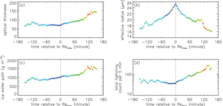
evolu-tion in radar products) cell tracks during summer 2011 show a strong correlation between COT, LWP, IWP and total lightning during both the growing and the decaying phase of Reff. Thus thicker, wetter clouds produce more
lightning (Fig. 1a, c and d). The relationship between
Reff and total lightning, however, is more complex.
To-tal lightning shows a strong increase after the trend re-versal in Reff (Fig. 1b and d). Some theories postulate
an increase in lightning activity when large ice particles aloft precipitate in the lower mixed-phase cloud region, which is consistent with the observed negative correla-tion between flash count and cloud-top Reff and the
ob-served mean time difference between the peaks in light-ning and Reff. For stronger storms, peak lightning
activ-ity increasingly lags peak Reff by up to 25–30 min for
the most intense storms. The observed lags presumably correspond to the time required for large cloud-top ice particles to fall and intensify charge separation. Anal-yses of convective cells captured with the polarimetric X-band radar in Bonn (BoXPol) after the Reff-maximum
confirm the occurrence of graupel and support the hy-pothesis that the trend reversal in Reffindicates the onset
of the charge separation. Graupel is associated with high reflectivities ZH and diminishing differential
reflectiv-ity ZDR(Fig.2). The hydrometeor classification scheme
(Zrni´c et al., 2001) confirms the presence of graupel in the mid and lower cloud region and smaller ice particles aloft. In agreement with the 3-body scattering signature visible in Fig. 2, a region with large hail particles has been identified. The signature appears as a radially ori-ented spike of weak ZHprotruding from the far side
(rel-ative to the radar) of the storm and a band of extremely large ZDRvalues.
The comparison of object evolutions in observations and models can be applied for model evaluation, because deviations may hint at processes not adequately simu-lated (e.g. Trömel and Simmer, 2012). Polarimetry is expected to be particularly beneficial for the evaluation of microphysical processes. A prominent example is the backscatter differential phase δ which is an indicator for the dominant size of rain drops or wet snowflakes. Its consideration allows for a better characterization of the brightband and can be utilized for improving micro-physical models (Trömel et al., 2013a,2013b). Another example is the derivation of synthetic cloud products from model forecasts. The frequency and size of convec-tive cells derived by the NWC SAF Rapidly Develop-ing Thunderstorm product for observations and COSMO forecasts can be used as metric for the model’s ability to simulate appropriate cell types (Rempel, 2013).
3.2 Data assimilation
Compared to global scales, research for convective-scale (km-resolution) data assimilation is at a much less ma-ture stage and it remains to be answered which meth-ods can cope with the strong non-linearities typically en-countered on this scale while meeting the demands for computational efficiency and frequent analysis updates. Ensemble methods are seen as a promising approach to address the limited predictability of small-scale systems (e.g. convection), but knowledge is particularly miss-ing on the appropriate representation of model error, the choice of specific observations for these scales and the
Meteorol. Z., 23, 2014 M. Weissmann et al.: Initial phase of the Hans-Ertel Centre for Weather Research 197
Figure 1: Evolution of satellite-retrieved cloud properties and ground-based total lightning count per 5 min time interval averaged over ∼1700 systems tracked with KONRAD and synchronized to the time of maximum effective radius (vertical dotted line). The colour indicates the KONRAD cell size, i.e. number of radar pixels (1 km2) with reflectivity greater 46 dBZ, ranging from less than or equal to 30 (blue) to greater than or equal to 120 (red).
Figure 2: Vertical cross-section of a storm during intense lightning activity from measurements of the polarimetric X band radar in Bonn
(BoxPo) on 5 June 2011 at 1359 UTC. The left panel shows the horizontal reflectivity ZH(in dBZ) and the right panel the differential reflectivity ZDR(in dB).
best way to assimilate them. Satellite instruments nowa-days provide a vast amount of information on the at-mospheric state, but only a very small fraction is used in current convective-scale assimilation systems. Based on these shortcomings, HErZ Data Assimilation (HErZ-DA) addresses four research topics: Data assimilation methodology for strongly nlinear dynamics, the on-line estimation of the impact of different observations, the representation of uncertainty in ensemble systems and the improved use of cloud-related satellite obser-vations. The satellite part comprises efforts to
assimi-late visible (VIS) and near-infrared (NIR) satellite re-flectance and the development of a height correction for cloud motion vectors based on satellite lidar observa-tions.
3.2.1 Data assimilation methodology
Limited computational resources prohibit testing multi-ple data assimilation methods extensively in a full NWP system and traditional test models for global-scale data assimilation (e.g. Lorenz, 1995) are missing key
fea-tures of predominant convective-scale processes. To ad-dress this, a hierarchy of idealized models that resem-ble convective-scale dynamics has been developed. This hierarchy is used to test data assimilation algorithms that were generally not designed for the non-linearity and non-Gaussian error structures encountered on these scales. At the lowest level of complexity, Craig and Würsch (2013)introduced a simple stochastic 1D cloud model based on a spatial Poisson birth-death process. At the second level, Würsch and Craig (2014) mod-ified the shallow-water equations to introduce convec-tion. This model represents conditional instability when-ever the water level exceeds a certain threshold and in-cludes the negative buoyancy effect of rainwater that limits the growth of convective clouds. For both mod-els, three data assimilation algorithms, the LETKF, Se-quential Importance Resampling (SIR;van Leeuwen, 2009) and the Efficient Particle Filter (van Leeuwen, 2011) are being tested.
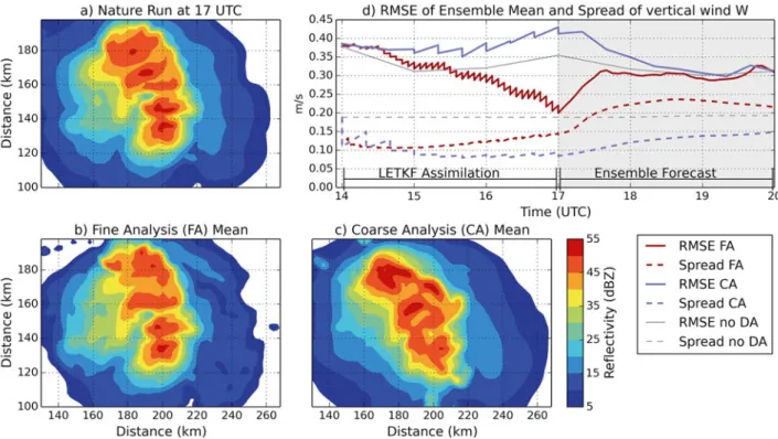
At the third level, idealized perfect model experi-ments are performed using the experimental KENDA-COSMO system with 2 km grid spacing. These studies focus on radar assimilation and the preservation of phys-ical properties following Janjic et al. (2014). A model run with idealized initial conditions is taken as “truth” (referred to as nature run) and observations simulated from this nature run are used to investigate different set-tings or implementations of KENDA.
Lange and Craig (2014) tested the assimilation of radar reflectivity and Doppler velocity in KENDA us-ing a nature run initialized with one vertical soundus-ing and small random perturbations to trigger convection. The major focus was the comparison of the following two setups: One producing initial conditions with high-resolution fine assimilation (FA) settings every 5 min and the other producing initial conditions with spatially coarse assimilation (CA) settings every 20 min. The fine assimilation converged closely to the observations whereas the coarse analysis was not able to resolve all storm details (compare Figs.3a, b and c). However, due to the limited predictability of convective-scale dynam-ics and imbalances in the strongly forced fine assimila-tion, the forecasts initialized from fine initial conditions quickly lost their superiority and the errors of vertical velocity were similar for both experiments after 1–2 h lead time (Fig.3d).
3.2.2 Observation impact
Knowledge about the contribution of different observa-tions to the reduction of forecast errors (referred to as observation impact) is crucial for both the refinement of observing as well as data assimilation systems. How-ever, the direct calculation through numerical data de-nial experiments (i.e. parallel experiments) is only fea-sible for specific applications and data sets due to com-putational expenses. Therefore, a comcom-putationally inex-pensive ensemble-based method for estimating obser-vation impact followingKalnay et al. (2012)has been
implemented in KENDA-COSMO (Sommer and Weiss-mann, 2014).
Figs. 4a and b exemplarily illustrate the (positive and negative, respectively) impact values of all obser-vations in one particular assimilation cycle. Consistent with previous studies using adjoint estimation methods (e.g. Weissmann et al., 2012), only slightly over 50 % of the observations (on average 54 %) contribute to an improved forecast due to the statistical nature of obser-vation impact.
The ensemble impact estimation has been systemat-ically tested by comparison to data denial experiments that exclude particular observation types (Sommer and Weissmann, 2014). Fig. 4c shows the estimated ra-diosondes impact and their impact in data denial experi-ments. Overall, the method is able to reproduce the gen-eral behaviour of the impact despite deviations for indi-vidual analysis cycles. Averaged over all observations during nine analysis cycles, the relative deviation be-tween the estimated and the data denial impact is about 10 % for different observation types. In addition, the dif-ferences were shown to be statistically not significant.
3.2.3 Representation of uncertainty
This part of HErZ-DA intends to improve the represen-tation of uncertainty in ensemble systems. A first study examined the relative contribution of different pertur-bations in the current regional COSMO ensemble pre-diction system of DWD (Kühnlein et al., 2014). The impact of initial condition perturbations that are down-scaled from a global multi-model ensemble was largest in the first six forecast hours. Thereafter, lateral bound-ary condition and physical parameter perturbations be-come more important. The impact of parameter pertur-bations is particularly important during weak large-scale forcing of precipitation (Keil et al., 2014). Ensemble as-similation systems as KENDA directly provide an es-timate of initial condition uncertainty. Ongoing studies investigate the structure and growth of KENDA pertur-bations and test different methods to account for model errors, e.g. relaxation to prior spread and a stochastic boundary layer scheme.
3.2.4 Satellite cloud observations
Traditionally, VIS and NIR satellite channels have been neglected for data assimilation due to the lack of suit-able fast observation operators. Given that convective systems are much earlier discernible through their cloud signal than through radar observations of precipitation, these cloud-related observations are seen to be particu-larly valuable for convective-scale modelling. HErZ-DA has developed a suitable operator for assimilating VIS and NIR satellite reflectance in KENDA (Kostka et al., 2014) and the assessment of their impact in KENDA is ongoing.
In addition, research in HErZ-DA uses CALIPSO (Cloud-Aerosol Lidar and Infrared Pathfinder Satellite
Meteorol. Z., 23, 2014 M. Weissmann et al.: Initial phase of the Hans-Ertel Centre for Weather Research 199
Figure 3: Idealized experiments to investigate convective-scale radar assimilation with an ensemble Kalman filter. (a) Composite radar
reflectivity of the nature (“truth”) run, (b) the corresponding ensemble mean of the fine analysis (FA) and (c) of the coarse analysis scheme (CA) after 3 h of cycled data assimilation. (d) RMSE and spread of vertical velocity of FA (red) CA (blue) and the experiment without data assimilation (no DA, grey) during cycled assimilation (white area) and free forecast (grey area).
5 10 15 46 48 50 52 54 56 (b) Longitude Latitude 5 10 15 46 48 50 52 54 56 (a) Longitude Latitude 1 2 3 4 5 6 7 8 9 10 8 6 4 2 0 x 108 Cycle Impact (c)
Data denial TEMP impact Approximated TEMP impact
Figure 4: Spatial distribution of approximated impact for all observations with beneficial (a) and detrimental (b) impact with marker size
proportional to the impact values. Forecast time 6 h from initialization at 8 August 2009 1200 UTC. (c) Data denial (blue) and approximated (black) impact of radiosonde observations. Dots represent the analysis influence and lines the evolution of the observation impact for forecast lead times up to 6 h from every analysis cycle.
Observations) information to correct the height assign-ment of cloud motion vectors. A method has been de-veloped to directly correct motion vectors heights with nearby lidar cloud top observations, at first in an ex-perimental framework with airborne observations dur-ing a field campaign (Weissmann et al., 2013) and subsequently using CALIPSO observations (Folger and Weissmann, 2014). The developed lidar correction leads to a significant reduction of motion vector wind er-rors by 12–17 %. Further studies will assess the benefit of such a correction for data assimilation, both by di-rectly assimilating height-corrected motion vectors and
through the development of situation-dependent correc-tion funccorrec-tions.
3.3 Model development
The overall aim of the HErZ Clouds and Convection (HErZ-CC) branch is to better understand the physi-cal processes that control the lifecycle of clouds and convection and to use this understanding to improve their representations in NWP models. Clouds are a de-cisive part of NWP and climate models. They intercon-nect the land surface, planetary boundary layer and the
deeper atmosphere and allow for a range of complex scale interactions. As some of these processes can be explicitly represented whereas other ones have to be parameterized, the treatment of clouds, even in high-resolution weather forecasts, essentially remains an un-solved problem. Most existing parameterizations make either explicitly or implicitly assumptions about scale-separation, convective quasi-equilibrium and sub-grid homogeneity which are becoming a road block for fur-ther improvements of NWP and climate models.
3.3.1 Large-eddy simulations (LESs)
Improving parameterizations requires better understand-ing of the processes at work as parameterizations en-capsulate an idealization of our understanding. Today supercomputers make it possible to perform LESs with grid spacings of some 10–100 m on mesoscale domains over periods of several days. Such simulations provide the data to develop and test new parameterization hy-potheses and they may also be used to estimate neces-sary parameters or functions. Process studies with LESs constitute the first line of research in HErZ-CC. It is here to emphasize that the best use of LESs is in improv-ing our understandimprov-ing of the processes and their inter-actions, not in reproducing reality.
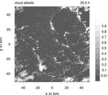
Figure5shows the result of such an LES of precipi-tating shallow cumulus clouds on a domain of 100 km× 100 km with an isotropic grid spacing of 25 m. Such a setup is able to resolve the larger turbulent eddies in the boundary layer, the internal circulations of the clouds as well as the mesoscale flow which leads to the self-organization of the cloud field (Seifert and Heus, 2013). Figure5shows the simulated albedo of a cumu-lus field with the typical cloud patterns as observed in the trade wind zones. These are the cloud streets that are due to along-wind oriented boundary layer rolls, the so-called mesoscale arcs, regions of deeper congestus-type clouds which may reach 4–6 km cloud top height and can produce locally intense precipitation and cloud-free areas in between. The LES data and additional sensitiv-ity studies suggest that the main cause of the organiza-tion are cold pools originating from the most intense rain events. However, the cold pools are relatively weak and short lived, i.e. the mesoscale patterns do not so much establish themselves in the temperature field, but only in the moisture field itself. Hence, modelling the structure and statistics of the sub-cloud layer moisture field as it evolves due to the effects of precipitation is key for a pa-rameterization which aims at representing the effect of cloud organization.
The cloud microphysics and radiation scheme of the LES model have also been extended to allow the simu-lation of deep convection (Hohenegger and Stevens, 2013;Schlemmer and Hohenegger, 2014) and a sim-ple land surface model (Rieck et al., 2014) has been in-troduced. This enables the investigation of the full diur-nal cycle of convection, from shallow to deep, including the interaction with the land surface.
Figure 5: Synthetic cloud albedo for the RICO LES case as
calcu-lated from simucalcu-lated cloud liquid water path after 35 h. Shown is the result of a simulation with the UCLA-LES model using 4096× 4096×160 grid points with an isotropic mesh of 25 m grid spacing. The resulting domain has a horizontal size of 100 km×100 km and can therefore include mesoscale cloud structures as the mesoscale arcs that are typically observed in precipitating shallow convection in the trade wind zone.
3.3.2 Understanding and parameterizing the cloud size distribution
The cloud size distribution (CSD) constitutes the sec-ond line of research in HErZ-CC. By providing ex-plicit information about the size of all clouds, the goal is to derive parameterizations that are appropriate for a given mesh size and are at the same time able to pro-vide information about sub-grid variability. It is worth noting that the original proposal of the mass flux con-vection scheme byArakawa and Schubert (1974) in-cluded the explicit prediction of different cloud sizes, i.e. a cloud size distribution. This concept has later been largely abandoned and replaced by the simpler bulk mass flux scheme (Tiedtke, 1989; Plant, 2010). In-cluding explicit assumptions about the size, life time and life cycle of convective clouds may also be a necessary pre-requisite for a consistent treatment of cloud micro-physics and rain formation. For example, Seifert and Stevens (2010)suggested that the use of dynamical and microphysical timescales may be a viable and promising alternative to the current formulation of microphysical parameterizations within convection schemes.
Having large-eddy simulations for several cloud regimes makes it possible to improve our understand-ing of small-scale variability and hence, to formulate improved parameterizations. Based on such data, Nau-mann et al. (2013) derived a refined cloud closure, which has now been handed over to DWD for prac-tical implementation and testing. Another major effort has been the development of a cloud tracking algo-rithm which is able to handle extensive datasets and at
Meteorol. Z., 23, 2014 M. Weissmann et al.: Initial phase of the Hans-Ertel Centre for Weather Research 201
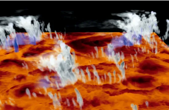
Figure 6: 3D snapshot of developing deep convection with clouds (white), precipitation (blue) and near-surface humidity (from low to high:
black-red-orange) from a LES simulation (grid spacing 100 m, domain size 125 km×125 km).
the same time includes a physically-based definition of cloud objects (Heus and Seifert, 2013). The clustering of clouds, which becomes especially pronounced in the presence of precipitation, requires splitting clouds into dynamically meaningful entities which is done based on the buoyant cloud cores. Using cloud tracking, a power law size distribution for the instantaneous shallow cu-mulus cloud field is found as it is also found based on satellite observations. At the same time, LES data provide detailed information on the cloud lifetime and cloud life-cycle which is necessary for the formulation of a stochastic cloud scheme, e.g. followingPlant and Craig (2008).
Changes in the CSD as the clouds transition to deep convection or due to heterogeneous surface conditions have also been investigated. In general, it is thought that a widening of the clouds as the diurnal cycle proceeds constitutes one of the necessary ingredients for transi-tion to deep convectransi-tion (e.g.Khairoutdinov and Ran-dall, 2006;Kuang and Bretherton, 2006).
Understanding mechanisms that influence the size of the largest clouds is therefore crucial. As soon as clouds begin to precipitate, the formation of cold pools shifts the CSD to larger scales and promotes the transi-tion to deep convectransi-tion (Schlemmer and Hohenegger, 2014). Figure6shows a snapshot of a cloud field transi-tioning to deep convection. New clouds form on the rim of the cold pools (visible as circular dry areas in Fig.6), where moisture has been accumulated. The size of the largest clouds seems to correlate with the size of these moist patches.
Likewise, surface heterogeneities can affect the for-mation of larger clouds (Rieck et al., 2014). Except for such changes in the scale break (i.e. largest clouds), the
CSD remains remarkably similar over homogeneous and heterogeneous surfaces. Accurately representing the ef-fects of cold pools and surface heterogeneity in convec-tive parameterizations is thus important to capture a cor-rect timing of the development of convection. The tran-sition time from shallow to deep convection was for in-stance reduced by half in a simulation performed over a heterogeneous surface with a heterogeneity length scale of 12.8 km. Such effects are unlikely to be correctly rep-resented, even in cloud-resolving NWP models and may explain a delayed onset of precipitation in such models.
3.4 Climate monitoring and diagnostics
The overall aim of HErZ-Climate is to develop and im-prove methods for the self-consistent assessment and analysis of regional climate in Germany and Europe over the past decades at an appropriate spatial and temporal resolution. The central approach to this is the develop-ment and evaluation of a model-based, high-resolution regional reanalysis system which encompasses the syn-ergetic use of heterogeneous monitoring networks while providing detailed diagnostics of the energy, water and momentum cycles of the reanalysed climate state.
In the scope of climate monitoring, reanalyses are becoming more and more important for the assessment of climate variability and climate change. The Euro-pean Union Global Monitoring for Environment and Security (GMES) initiative has recently started fund-ing for generatfund-ing reanalyses and the verification of the corresponding data sets. These efforts are directed to-wards establishing climate services based on reanalyses. HErZ-Climate takes part in the EU-FP7 funded projects UERRA (Uncertainties in Ensembles of Regional Re-analysis) as well as CORE-CLIMAX in order to provide
impetus for the continuous development, production and dissemination of regional reanalyses towards a climate services framework.
3.4.1 Criteria for regional reanalyses
Within the meteorological and climate community, the term reanalysis is commonly understood as the synthesis of past observations – heterogeneous in space and time – into a physical model using a state-of-the-art assimila-tion system. By freezing the model and data assimilaassimila-tion system, it avoids systematic variations that otherwise ap-pear in operational NWP analyses. Such a model-based approach yields the advantage of generating 4D fields for a large number of atmospheric variables, which are physically consistent in space and time as well as be-tween the parameters.
Gridded climate data products based on alternative approaches such as spatio-temporal interpolation meth-ods do not meet these criteria. Commonly used atmo-spheric reanalyses include ERA-Interim (ECMWF Re-Analysis, Dee et al., 2011) and MERRA (Modern-Era Retrospective analysis for Research and Applications,
Rienecker et al., 2011) by the National Oceanic and At-mospheric Administration (NOAA). Such reanalyses fa-cilitate a large observational data set, a global circulation model and a corresponding data assimilation scheme. The horizontal grid-spacing of global reanalyses is usu-ally in the range of 70–125 km and the temporal resolu-tion of the output normally coincides with the 6-h inter-val between two assimilation cycles, sometimes comple-mented by the output of 3-h forecasts. For a better rep-resentation of spatio-temporal variability including lo-cal extreme events, the regional enhancement of global reanalysis data has become an important task. An ap-proach for the European region is presented in sections
3.4.2and 3.4.3.
The added value of high-resolution regional reanal-yses lies in the enhanced representation of spatio-temporal variability and extremes and, most importantly, in the spatio-temporal coherence with independent ob-servations.Simon et al. (2013)showed that regional dy-namical downscaling methods generate variability in the inner-domain by itself, whereas data assimilation on re-gional scales suppresses this freely developing variabil-ity.
Such regional reanalysis systems provide a quality-controlled and homogenised data set for the detection and assessment of regional climate change in the past and the future, the statistical post-processing of opera-tional forecasts, the analysis of systematic model errors of the respective regional model as well as the verifica-tion and calibraverifica-tion of climate impact models.
3.4.2 Regional reanalysis for the European CORDEX domain
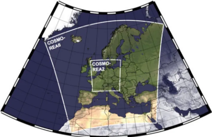
HErZ-Climate generated a high-resolution regional re-analysis for the CORDEX EUR-11 domain (COordi-nated Regional Downscaling Experiment, cf. Fig. 7),
Figure 7: A map of Europe showing the domains for the European
reanalysis (COSMO-REA6, approx. 6 km resolution, 880×856 grid points) and the German reanalysis (COSMO-REA2, approx. 2 km resolution, 724×780 grid points).
but with an increased resolution of the horizontal grid to 0.055 ° (∼ 6 km). The reanalysis consists of the DWD COSMO model and its nudging (or dynamical relaxation) assimilation system. The atmospheric anal-ysis is complemented by a soil moisture, a sea sur-face temperature and a snow analysis module. In a first stream, reanalysis data have been produced for the pe-riod 2007–2011. The following part of this section pro-vides findings from the comparison of COSMO-REA6 and ERA- Interim. A detailed analysis including various parameters can be found in Bollmeyer et al. (submit-ted).
At first, precipitation estimates of the two reanalyses against rain gauge observations over Germany have been evaluated. The difficulty when evaluating the quality of precipitation estimates is that it follows a non-Gaussian distribution and therefore standard scores such as bias or RMSE are inadequate. Therefore, histograms of 3-hourly precipitation over Germany were analysed in or-der to investigate the quality of precipitation reanalyses. Histograms for the observations, COMSO-REA6 and ERA-Interim are presented in Figure 8. The dia-grams show the frequency of occurrence for weak (up-per panel) and heavy precipitation events (lower panel). For the frequent weak precipitation events, COSMO-REA6 performs well compared to observations while ERA-Interim shows an underestimation of event fre-quency for values below 0.1 mm and above 5 mm per 3 h. For values of 0.1–5 mm per 3 h, ERA-Interim over-estimates the frequencies of events.
For the less frequent heavy precipitation events, the histogram bins are restricted to values above 20 mm per 3 h. COSMO-REA6 underestimates the frequencies of the observed precipitation, especially in the range of 20–30 mm. However, COSMO-REA6 still represents extreme precipitation events, with the frequency of oc-currence being well-estimated for precipitation events of 50 mm and beyond. In contrast, ERA-Interim does not exhibit values that exceed 22 mm in 3 h at all. This is
Meteorol. Z., 23, 2014 M. Weissmann et al.: Initial phase of the Hans-Ertel Centre for Weather Research 203
Figure 8: Histograms of 3-hourly precipitation over Germany for
2011 for rain gauge observations (green), ERA-Interim (red) and COSMO-REA6 (blue) for weak (upper diagram) and heavy (lower diagram) precipitation events.
in accordance with the change of support as rain gauge observations are point measurements while reanalyses represent area-averaged values.
The results from the first stream of COSMO-REA6 underline the added value of high-resolution regional re-analyses as a tool to monitor regional climate. The in-creased resolution allows a better representation of sur-face parameters and meso-scale processes leading to an improved reproduction of local variability of the climate such as extreme events. Especially in the context of se-vere weather, the understanding of climate variability on these scales is becoming more and more important.
3.4.3 Towards a regional reanalysis on the convection-permitting scale
Currently, the production of a horizontally refined convection-permitting scale reanalysis is under way. With 2-km grid size for a domain covering Germany and adjacent areas (Fig. 7), the reanalysis COSMO-REA2 allows the direct representation of deep convection. The reanalysis is supported by a latent heat nudging (LHN) scheme which assimilates radar data to allow for a better representation of rainfall.
First results of COSMO-REA2 for summer 2011 indicate that the precipitation analysis is further im-proved, especially with regard to the diurnal cycle. Fig-ure 9 shows the precipitation intensity for all 3-h in-tervals of the day for June, July and August 2011. In comparison to the observed precipitation, it can be observed that ERA-Interim does not represent the diurnal cycle with precipitation intensities remaining nearly constant throughout the day. In COSMO-REA6,
Figure 9: Diurnal cycle of precipitation intensity (3-hourly
av-erages) for June 2011 over Germany. Values for the observa-tions (green), ERA-Interim (red), COSMO-REA6 (dark blue) and COSMO-REA2 are shown.
a diurnal cycle is present with the correct amplitude but lagged by approximately 3 h while in COSMO-REA2 the diurnal cycle is reproduced nearly perfectly, thereby showing the benefits of a convection-permitting reanalysis.
3.5 Communication and use of forecasts and warnings
At the end of the forecasting process, the value of fore-casts is only accomplished if end users make better deci-sions, e.g. to mitigate the impact of hazardous weather. In order to be able to make optimal use of the informa-tion contained in the forecast, the users’ vulnerability must be known and suitable mitigation measures must be available. Furthermore, forecasting products must be disseminated reliably, they must be understood and ac-cepted. All these aspects of optimal forecast usage can only be investigated by a transdisciplinary approach in-cluding social sciences, relevant institutions and stake-holders.
Research on this final step of the forecasting pro-cess has been scarce in Germany, yet there have been some efforts in the United States and Australia (e.g. the “Weather And Society Integrated Studies” (WAS-IS) initiative) or in the United Kingdom (Roulston et al., 2006) and the topic has been addressed in the World Weather Research Programme (WWRP) and the THOR-PEX programme of the World Meteorological Organiza-tion (WMO, 2004).
HErZ-Application investigates weather warnings and their perception and use by emergency managers and the public. The applied methods range from statistical modelling to surveys, direct observations of emergency managers and stakeholder interviews. The main focus in the initial phase of HErZ are warnings for wind storms and thunderstorms in Berlin. The goal is to improve the warning process and the communication of warnings and to develop recommendations for user-oriented in-formation products. One overarching aspect is the treat-ment of uncertainty information.
Figure 10: Participants of the online survey were asked: “When receiving a thunderstorm warning via FeWIS, how often do you expect a
thunderstorm to actually happen?” The red arrow indicates the range of the objectively verified rate of occurrence of an event in a county after a thunderstorm warning was issued (Göber, 2012).
3.5.1 Estimation and perception of uncertainty
Although weather warnings are uncertain, they are still delivered without an explicit indication of their weather-dependent uncertainty. To investigate the usefulness of uncertainty information for emergency managers, a test product has been designed with the help of DWD’s re-gional office responsible for Berlin. It consists of prob-abilistic short range forecasts of warning events for 6-h time intervals. As a first step, this human-made forecast has been verified and compared to a statistical forecast. Both forecasts were very reliable, at least for moderately severe events. Note, that this good calibration of the forecasters has been achieved without providing feed-back to them yet.
DWD provides weather warning information to emer-gency managers via the online platform FeWIS (Feuer-wehr-Wetterinformationssystem). Access to this plat-form is limited to emergency managers from dispatch centres, professional, voluntary and private fire brigades and other relief units. An online survey on this plat-form has been conducted to assess how much emergency managers are aware of uncertainties, how much trust they put in the information and how they are affected by failed weather warnings. In a previous survey,Frick and Hegg (2011)investigated the users’ assessment of and trust in a similar Swiss online platform for hydrologic and atmospheric hazards. 174 FeWIS users responded: 59 % represent fire brigades and dispatch centres, 26 % are emergency managers and 14 % belong to other relief units. The survey showed that 60 % of respondents rated the frequency of false alarms at least as “acceptable”. Only 13 % of participants replied that false alarms are too frequent or much too frequent.
Another question was how participants estimated the frequency of false alarms. The vast majority of emer-gency managers expects thunderstorms to occur for 60–90 % of warnings (Fig.10). The objectively verified rate of occurrence of an event after a thunderstorm warn-ing was issued by DWD however, is significantly lower. Depending on the regional forecast centre, the rate is in the range of 40–55 % (Göber, 2012). It is unclear whether meteorologists and emergency managers define false alarms in the same way. A thunderstorm for ex-ample, that hits uninhabited regions or does not cause missions might not be perceived as an event by emer-gency managers. Thus, emeremer-gency managers put high trust into weather warnings issued by DWD although they are aware of uncertainties.
An open question was posed about the consequences of false alarms. 35 % of responders claimed to suf-fer no consequences. About two thirds prepared for an event, mostly by reinforcing staff for relief missions and dispatch centres by prolonging work shifts, setting up standby duty or calling in voluntary fire brigades. One quarter of survey participants reported that they took precautionary measures, which then turned out to be not needed. Those measures included cancelling outdoor events, checking equipment and installing de-fences. Roughly 20 % of emergency managers raised the concern that false alarms cause reduced trust in warnings by both DWD and their own institution.
Complementary to the effects of false alarms, the consequences of missed events have been investigated. Here, only 10 % of respondents claimed to suffer no con-sequences. 35 % of respondents were troubled by lack-ing of staff in dispatch centres and for rescue forces.
Meteorol. Z., 23, 2014 M. Weissmann et al.: Initial phase of the Hans-Ertel Centre for Weather Research 205
The former is particularly critical if it leads to a queu-ing of emergency calls. The latter means to alert late and wait for reinforcements and therefore causes a de-lay of counter measures and emergency responses. Ad-ditionally, reinforcing personnel might be obstructed by weather effects.
Another 35 % of respondents suffered from being un-prepared. Resources and material were not available and emergency managers struggled to keep track of the sit-uation and to plan missions. Probably the most severe consequence is putting people at risk (when not send-ing out warnsend-ings, e.g. to outdoor events) and suffersend-ing avoidable damage. This was named in 20 % of the an-swers. Loss of trust was listed only by 3 % of respon-ders.
Another online survey aimed at a larger audience within the emergency management community: Kox et al. (2014) investigated the perception and use of un-certainty information in severe weather warnings. The results showed that the emergency service personnel who participated in this survey generally had a good ap-praisal of uncertainty in weather forecasts. When asking for a probability threshold at which mitigation actions would start, a broad range of values was mentioned and a tendency to avoid decisions based on low probabilities was detected. Furthermore, additional uncertainty was noted to arise from linguistic origins, e.g. context de-pendence, underspecificity, ambiguity and vagueness.
3.5.2 Risk analysis and risk communication
The vulnerability of people and infrastructure plays a major part in the analysis of risks, especially for large cities. One important aspect of risk mapping is the dis-tribution of trees, since storm damaged trees pose a ma-jor thread, e.g. to people, cars or rail tracks. Here, Berlin is particularly vulnerable since its 5342 km of streets are lined, on average, by about 80 trees per km. Trees are stressed in cities because of water deficiency, heat, pol-lution, bad soil conditions, small rooting spaces, etc. In-ter alia, this leads to a weakening of wood or defence against insect attacks. Vulnerability is dependent on tree species and age (wood flexibility), size (height, crown), foliation and other factors.
Mass media are the major public source of informa-tion about impending severe weather (Ulbrich, 2013). A content analysis of television weather reports of the 26 most severe winter storms has been conducted with the goal to relate the information and its quality to observed and modelled losses (Donat et al., 2011). In a semi-experimental setting, the understanding of TV weather reports has been tested with about 200 students in order to investigate how they perceived and understood the in-formation and whether they derived actions from it.
4
Summary and outlook
The initial phase of HErZ has triggered a number of activities in the areas of weather forecasting and
cli-mate research. Basic research within HErZ comple-ments more applied internal research at DWD. In addi-tion, HErZ significantly intensifies the collaboration be-tween universities, research institutions and DWD. This is seen as a benefit for both the host institutions and DWD. Training young scientist is also a key component of HErZ. All branches are actively involved in course teaching and several special training events have been conducted. In addition, a number of doctoral, master and bachelor students have completed or are working on their thesis in the framework of HErZ.
HErZ has been established as a virtual research cen-tre and contributes to better understanding of atmo-spheric processes, ways to observe and represent them in numerical models and ways to forecast them to mit-igate their impact. Specific contributions of the current HErZ to improved understanding address:
• The structure, life-cycle, precipitation efficiency and organization of shallow and deep convection; • The differences between convective-scale and
syn-optic-scale data assimilation;
• Representation of different sources of uncertainty in ensemble systems;
• The effects of land surface heterogeneities and soil moisture on the formation of convective clouds; • Regional and local climate variability;
• The perception and use of forecasts.
In addition to an improved understanding, a number of specific methods, tools and data sets have been devel-oped in HErZ. In the course of future phases of HErZ, the research shall feed into improved modelling, moni-toring and forecasting capabilities. More specifically, re-search of HErZ shall lead to:
• Seamless short-term weather prediction by means of a more detailed process description in nowcasting and high-resolution data assimilation;
• Improved assimilation systems through additional observations and new tools;
• Improved and scale-adaptive parameterizations of clouds and convection;
• Improved monitoring of past weather and climate; • Improved communication and use of forecast
uncer-tainty and weather warnings.
The five branches of HErZ address different aspects of weather or climate research, but they share common research topics as for example regional high- resolu-tion (km-scale) modelling. Clouds, convecresolu-tion and hy-drometeors are another important aspect for the first four branches and research ranges from polarimetric radar observations to cloud tracking, cloud motion vectors, as-similation of cloud observations, idealized LES of cloud regimes, suitable parameterizations and cloud valida-tion. Further joint research areas include observation forward operators, data assimilation, probabilistic fore-casting and the verification and validation of analyses and forecasts.
The current HErZ research covers the whole chain of topics relevant for weather forecasting and climate monitoring ranging from understanding of processes over methods to represent these in observation-based nowcasting and numerical models to ways of condens-ing and communicatcondens-ing the observational and model-based information to end users. By this, it brings to-gether basic with applied research, observational with modelling expertise, academic with weather service ex-perience and scientists with end users.
HErZ has overcome the difficulty of initiating and establishing such an unprecedented collaboration of DWD, universities and research institutes. It has trig-gered and intensified research in important, as yet under-represented subjects at universities. The remaining chal-lenges for the long-term success of HErZ will be to de-velop sustainable structures based on currently limited-term funding for the branches and long-limited-term career per-spectives for people working in HErZ.
Establishing the centre has also been accompanied by comparably high management efforts given the cen-tre’s strategic and structural goals in addition to research objectives. Thus, finding a good balance between struc-tural demands and the focus on its primary objective of excellent science as well as a good balance of funda-mental research and research motivated by and focused on needs of a weather service are seen as crucial tasks for lasting scientific success.
Acknowledgement
The presented research was carried out in the Hans-Ertel Centre for Weather Research. This German research network of universities, research institutes and DWD is funded by the BMVBS (Federal Ministry of Transport, Building and Urban Development). Furthermore, the authors want to acknowledge the Scientific Advisory Committee of DWD and particularly Mr. Wolfgang
Kusch, Prof. Clemens Simmer, Prof. Sarah Jones and
Prof. Gerhard Adrian for their efforts to initiate this unique collaboration of universities, research institutes and DWD.
References
Arakawa, A., W.H. Schubert, 1974: Interaction of a Cumulus
Cloud Ensemble with the Large-Scale Environment, Part I. – J. Atmos. Sci. 31 674–701.
Bengtsson, L., 2001: The development of medium range
fore-casts. – In: 50th Anniversary of Numerical Weather Pre-diction, Commemorative Symposium Potsdam 9–10 March 2000, Germany, Ed. A. Spekat 119–138.
Betz, H.D., K. Schmidt, P. Laroche, P. Blanchet, W. Oet-tinger, E. Defer, Z. Dziewit, J. Konarski, 2009: LINET
An international lightning detection network in Europe. – At-mos. Res. 91 564–573.
Bjerknes, V., 1904: Das Problem der Wettervorhersage,
betra-chtet vom Standpunkt der Mechanik und Physik. – Meteo-rol. Z. 21 1–7.
Bley, S., H. Deneke, 2013: A robust threshold-based cloud
mask for the HRV channel of MSG SEVIRI. – Atmos. Meas. Tech. 6 2713–2723.
Bollmeyer, C., J.D. Keller, C. Ohlwein, S. Bentzien, S. Crewell, P. Friederichs, K. Hartung, A. Hense, J. Ke-une, S. Kneifel, I. Pscheidt, S. Redl, S. Steinke,
submit-ted: Towards a high-resolution regional reanalysis for the Eu-ropean CORDEX domain. – Quart. J. Roy. Meteor. Soc.
Craig, G.C., M. Würsch, 2013: The impact of localization and
observation averaging for convective-scale data assimilation in a simple stochastic model. – Quart. J. Roy. Meteor. Soc. 139 515–523.
Comaniciu, D., P. Meer, 2002: Mean Shift: A Robust Approach
Toward Feature Space Analysis. – IEEE Transactions on Pat-tern Analysis and Machine Intelligence 24 603–619.
Dee, D.P., S.M. Uppala, A.J. Simmons, P. Berrisford, P. Poli, S. Kobayashi, U. Andrae, M.A. Balmaseda, G.
Bal-samo, P. Bauer, P. Bechtold, A.C.M. Beljaars, L. van de Berg, J. Bidlot, N. Bormann, C. Delsol, R. Dra-gani, M. Fuentes, A.J. Geer, L. Haimberger, S.B. Healy, H. Hersbach, E.V. Hólm, L. Isaksen, P. Kållberg, M. Köh-ler, M. Matricardi, A.P. Mcnally, B.M. Monge-Sanz, J.-J. Morcrette, B.-K. Park, C. Peubey, P. de Rosnay, C. Tavolato, J.-N. Thépaut, F. Vitart, 2011: The
ERA-Interim reanalysis: configuration and performance of the data assimilation system. – Quart. J. Roy. Meteor. Soc. 137 553–597.
Deneke, H., R. Roebeling, 2010: Downscaling of METEOSAT
SEVIRI 0.6 and 0.8 micron channel radiances utilizing the high-resolution visible channel. – Atmos. Chem. Phys. 10 9761–9772.
Dietzsch, F., 2013: Validierung satellitenbasierter
Früherken-nung konvektiver Gewitter mittels Rückwärtstrajektorien. – Master’s thesis, Faculty of Physics and Earth Sciences, Uni-versity of Leipzig.
Donat, M.G., T. Pardowitz, G.C. Leckebusch, U. Ulbrich, O. Burghoff, 2011: High-Resolution refinement of a storm
loss model and estimation of return periods of loss-intensive storms over Germany. – Natural Hazards Earth Sys. Sci. 11 2821–2833.
Edwards, P.N., 2010: A vast machine: computer models, climate
data, and the politics of global warming. – MIT press, Cam-bridge, ISBN 978-0-262-01392-5.
Folger, K., M. Weissmann, 2014: Height correction of
at-mospheric motion vectors using satellite lidar observations from CALIPSO. – J. Appl. Meteor. Climatol., 53 1809–1819, DOI:10.1175/JAMC-D-13-0337.1.
Frick, J., C. Hegg, 2011: Can end-users’ flood management
decision making be improved by information about forecast uncertainty? – Atmos. Res. 100 296–303.
Göber, M., 2012: Verifikationsbericht zur Güte lokaler
Wetter-prognosen. No. 45. – Deutscher Wetterdienst.
Gramelsberger, G., 2009: Conceiving meteorology as the
ex-act science of the atmosphere: Vilhelm Bjerknes’s paper of 1904 as a milestone. – Meteorol. Z. 18 669–673.
Hense, A., V. Wulfmeyer, 2008: The German Priority Program
SPP1167 “Quantitative Precipitation Forecast”. – Meteorol. Z.
17 703–705.
Heus, T., A. Seifert, 2013: Automated tracking of shallow
cumulus clouds in large domain, long duration large eddy simulations. – Geosci. Model Dev. 6 1261–1273.
Hohenegger, C., B. Stevens, 2013: Preconditioning deep
con-vection with cumulus congestus. – J. Atmos. Sci. 70 448–464.
Horváth, Á., K. Wapler, F. Senf, H. Deneke, M. Diedrich, J. Simon, S. Trömel, 2012: Lagrangian analysis of
precipita-tion cells using satellite, radar, and lightning observaprecipita-tions. – Ext. Abstracts, 2012 EUMETSAT Meteorological Satellite Conference, 3–7 September 2012, Sopot, Poland.
Meteorol. Z., 23, 2014 M. Weissmann et al.: Initial phase of the Hans-Ertel Centre for Weather Research 207
Hunt, B.R., E.J. Kostelich, I.S. Zunyogh, 2007: Efficient
data assimilation for spatiotemporal chaos: A local ensemble transform Kalman filter. – Physica D 230 112–126.
IPCC, 2012: Managing the Risks of Extreme Events and
Disas-ters to Advance Climate Change Adaptation. A Special Report of Working Groups I and II of the Intergovernmental Panel on Climate Change. Field, C.B., V. Barros, T.F. Stocker,
D. Qin, D.J. Dokken, K.L. Ebi, M.D. Mastrandrea, K.J. Mach, G.-K. Plattner, S.K. Allen, M. Tignor, P.M. Midgley (Eds.). – Cambridge University Press,
Cam-bridge, UK, and New York, USA, 582 pp.
Jakob, C., 2010: Accelerating progress in global atmospheric
model development through improved parametrizations Chal-lenges, opportunities and strategies. – Bull. Amer. Meteor. Soc. 91 869–875.
Janjic, T., D. Mclaughlin, S.E. Cohn, M. Verlaan, 2014:
Conservation of mass and preservation of positivity with ensemble-type Kalman filter algorithms. – Mon. Wea. Rev.
142 755–773.
Kalnay, E., Y. Ota, T. Miyoshi, J. Liu, 2012: A simpler
for-mulation of forecast sensitivity to observations: application to ensemble Kalman filters. – Tellus A 64 18462.
Keil, C., F. Heinlein, G.C. Craig, 2014: The convective
ad-justment time-scale as indicator of predictability of convec-tive precipitation. – Quart. J. Roy. Meteor. Soc. 140 480–490, DOI:10.1002/qj.2143.
Khairoutdinov, M., D. Randall, 2006: High-resolution
sim-ulation of shallow- to-deep convection transition over land. – J. Atmos. Sci. 63 3421–3436.
Kostka, P.M., M. Weissmann, R. Buras, B. Mayer, O. Stiller, 2014: Observation Operator for Visible and
Near-Infrared Satellite Reflectances. – J. Atmos. Ocean. Technol.,
31 1216–1233, DOI:10.1175/JTECH-D-13-00116.1.
Kox, T., L. Gerhold, U. Ulbrich, 2014: Perception and
use of uncertainty in severe weather warnings by emer-gency services in Germany. – Atmos. Res., published online, DOI:10.1016/j.atmosres.2014.02.024
Kuang, Z., C.S. Bretherton, 2006: A mass-flux scheme view
of a high- resolution simulation of a transition from shallow to deep cumulus convection. – J. Atmos. Sci. 63 1895–1909.
Kühnlein, C., C. Keil, G.C. Craig, C. Gebhardt, 2014:
The impact of downscaled initial condition perturbations on convective-scale ensemble forecasts of precipitation. – Quart. J. Roy. Meteor. Soc., 140 1552–1562, DOI:10.1002/qj.2238.
Lange, H., G.C. Craig, 2014: On the benefits of a high
reso-lution analysis for convective data assimilation of radar data using a local ensemble Kalman filter. – Mon. Wea. Rev, pub-lished online, DOI:10.1175/MWR-D-13-00304.1.
Lorenz, E.N., 1995: Predictability: A problem partly solved. –
In Proc. Sem. Predictability 1 1–18.
Milan, M., D. Schuettemeyer, T. Bick, C. Simmer, 2014:
A Sequential Ensemble Prediction System at Convection-Permitting Scales. – Meteor. Atmos. Phys. 123 17–31.
Naumann, A.K., A. Seifert, J.P. Mellado, 2013: A refined
statistical cloud closure using double-Gaussian probability density functions. – Geosci. Model Dev. 6 1641–1657.
Plant, R.S., 2010: A review of the theoretical basis for bulk
mass flux convective parameterization. – Atmos. Chem. Phys.
10 3529–3544.
Plant, R.S., G.C. Craig, 2008: A Stochastic Parameterization
for Deep Convection Based on Equilibrium Statistics. – J. At-mos. Sci. 65 87–105.
Reich, H., A. Rhodin, C. Schraff, 2011: LETKF for the
non-hydrostatic regional model COSMO-DE. COSMO Newslet-ter 11, 27–31. – Available at http://www.cosmo-model.org/ content/model/documentation/newsLetters/newsLetter11
Rempel, M., 2013: Gewittervorhersage auf dem Prüfstand
Möglichkeiten der objekt-basierten COSMO-DE Validierung mittels Satellitenprodukt RDT. – Bachelor’s thesis, Faculty of Physics and Earth Sciences, University of Leipzig.
Rieck, M., C. van Heerwaarden, C. Hohenegger, 2014:
The influence of land surface heterogeneity on cloud size development. – Mon. Wea. Rev, published online, DOI:10.1175/MWR-D-13-00354.1.
Rienecker, M.M., M.J. Suarez, R. Gelaro, R. Todling, J. Bacmeister, E. Liu, M.G. Bosilovich, S.D. Schubert, L. Takacs, G.-K. Kim, S. Bloom, J. Chen, D. Collins, A. Conaty, A. da Silva, G. Wu, J. Joiner, R.D. Koster, R. Lucchesi, A. Molod, T. Owens, S. Pawson, P. Pegion, C.R. Redder, R. Reichle, F.R. Robertson, A.G. Ruddick, M. Sienkiewicz, J. Woollen, 2011: MERRA – NASA’s
Modern-Era Retrospective Analysis for Research and Appli-cations. – J. Climate 24 3624–3648.
Rosenfeld, D., D. Atlas, D.A. Short, 1990: The Estimation
of Convective Rainfall by Area Integrals, 2. The Height-Area Rainfall Threshold (HART) Method. – J. Geophys. Res. 95 2161–2176.
Roulston, M.S., G.E. Bolton, E.N. Kleit, A.L. Sears-Collins, 2006: A laboratory study of the benefits of including
uncertainty information in weather forecasts. – Wea. Forecast.
21 116–122.
Ryzhkov, A., M. Diedrich, C. Simmer, 2013: Potential
utiliza-tion of specific attenuautiliza-tion for rainfall estimautiliza-tion, mitigautiliza-tion of partial beam blockage, and radar networking. – J. Atmos. Ocean. Technol. 31 599–619.
Schlemmer, L., C. Hohenegger, 2014: The formation of wider
and deeper clouds as a result of cold-pool dynamics. – J. At-mos. Sci., 71 2842–2858, DOI:10.1175/JAS-D-13-0170.1.
Seifert, A., T. Heus, 2013: Large-eddy simulation of organized
precipitating trade wind cumulus clouds. – Atmos. Chem. Phys. 13 5631–5645.
Seifert, A., B. Stevens, 2010: Microphysical Scaling Relations
in a Kinematic Model of Isolated Shallow Cumulus Clouds. – J. Atmos. Sci. 67 1575–1590.
Senf, F., H. Deneke, M. Diedrich, Á. Horváth, C. Seimmer, J.L. Simon, S. Trömel, K. Wapler, 2012: On severe
con-vective storms over Central Europe: satellite products within a case study. – Proceedings of 2012 EUMETSAT Meteorologi-cal Satellite Conference, 3–7 September 2012, Sopot, Poland.
Siewert, C.W., M. Koenig, J.R. Mecikalski, 2010:
Applica-tion of Meteosat second generaApplica-tion data towards improving the nowcasting of convective initiation. – Meteor. Appl. 17 442–451.
Simon, T., D. Wang, A. Hense, C. Simmer, C. Ohlwein, 2013:
Generation and transfer of internal variability in a regional climate model. – Tellus A 65 22485.
Sommer, M., M. Weissmann, 2014: Observation Impact in
a Convective-Scale Localized Ensemble Transform Kalman Filter. – Quart. J. Roy. Meteor. Soc., published online, DOI:10.1002/qj.2343.
Tiedtke, M., 1989: A Comprehensive Mass Flux Scheme for
Cumulus Parameterization in Large-Scale Models. – Mon. Wea. Rev. 117 1779–1800.
Trömel, S., C. Simmer, J. Braun, T. Gerstner, M. Griebel,
2009: Towards the use of Integral Radar Volume Descrip-tors for quantitative areal precipitation estimation results from pseudo-radar observations. – J. Atmos. Ocean. Technol. 26 1798–1813.
Trömel, S., C. Simmer, 2012: An object-based approach for
areal rainfall estimation and validation of atmospheric mod-els. – Meteor. Atmos. Phys. 115 139–151.