Mr.K.NARESH
M.Tech, Computer Science &Engineering
Department of CSE
Vaagdevi College Of Engineering, Warangal
Mr.A.RAMESHBABU
Assistant professor, Department of CSE
Vaagdevi College Of Engineering, Warangal
Abstract:Mobile technology is one of the speedydeveloping applied sciences to support the verbal
exchange among the many humans.With the large
development in mobile technology, humans of the
mobile user want to understand the understanding
related totheir wants which is based LBS (location
based service). Lacking the monitoring infrastructure
for avenue visitors, the LBS couldreceive are living
journey occasions of routes from on-line route APIs
with a view to offer correct outcome. Our purpose is
todiminish the quantity of requests issued via the
LBS significantly at the same time keeping accurate
query results.First, we advise to exploit latest routes
requested from route APIs to reply queries safely.
Then,we design strong cut down/higher bounding
systems and ordering methods to procedure
queriesefficaciously. Also, we study parallel route
requests to further shrink the query response time.
Keywords-Wireless Network, Mobile technology,
LBS, Accurate and Efficient Query
I. INTRODUCTION
There may be growing want for useful tactics
involving use of global positioning systems (GPS)
information fromGPS trackers for traffic evaluation.
In recent years, endeavor-founded evaluation making
use of GPS equipments as datacollectors has been a
most important assignment. All these types of study
center of attention on data from wearable GPS
recordersconsidering the fact that of effortless
distinctive assignment logging and interactive
validation with users. As data have expanded,extra
sophisticated strategies of data assortment have been
developed, represented to start with by means of the
shift from travel toundertaking diaries, and carrying
on with on to the development of GPS enabled
recreation surveying. Traffic analysis is a elementof
key features in constructing worldwide areas that
require better and efficient monitoringin an effort to
catch up on uncertainties in journey time as a result
of accidents, dangerous weather, traffic congestion,
and soon, automobiles hauling time-touchy freight
construct “buffer time” into their routes so as to aid
ensure that deliverieswill normally be made on time.
Building buffer time into routes tends to develop the
probability of on-time delivery, anessential measure
of service. However, buffer time also tends to slash
measures of productivity associated with cost,similar
to driver and equipment idle time and the number of
miles travelled per hour. An LBS requires 5
commonaccessories: the service provider’s program
functions, a mobilenetwork to transmit understanding
and requests forprovider, a content material provider
to supply the top user with geo-specified expertise, a
positioning factor and the topuser's mobile gadget.
Investigation of Accurate and Efficient Query Processing
By law, vicinity-founded offerings must be
permission-based. That means that the end user
desires to come to a decision-in tothe provider in an
effort to use it. Most of the time, this implies putting
in the LBS utility and accepting a request to permit
thecarrier to grab the device location. Our rationale of
this paper is to show off that real-time traffic
information combined withancient traffic data may
also be utilized to enhance routing systems that are
inclined to improve each rate and repairproductivity
measures.
Computing the shortest route is fundamental
assignment within the spatial databases. The trail
computed via using thepre-saved data isn't correct.
For that reason, there may be necessity for the live
visitors data. There are a quantity of on-lineprovider
site visitors providers like Navteq [1], Tom tom [2],
Google maps [3]. Nonetheless these traffic vendors
don't furnishknowledge continually due to excessive
cost. User-server structure is prior used for the
shortest course retrievalsthe position the buyer sends
the request and server responds to it.Shortest distance
queries are fundamental for two reasons. First
shortest distance queries are important in many
graphfunctions. For instance, in a social network,
we're fascinated by discovering the shortest distance
between two locations. Are livingsite visitors index
selectively fetches capabilities in Wi-Fi broadcast
environments, which drastically reduce the tune-in
cods.
II. RELATED WORKS
M. Arjun& K. Sirisha proposed a system based on
Live Activity List to calculate shortest Path between
source anddestination. They two implementations of
this thought, one founded on an easy grid information
structure and onebased on highway hierarchies. For
the road map of the United States, their best query
instances give a boost over thebest previously
published figures through two orders of magnitude.
Under the raw transmission model, the
trafficinformation (i.e. edge weights) is broadcasted
by way of a set of packets for each broadcast cycle.
Uninformed search(e.g. Dijkstra’s algorithm)
traverses graph nodes in ascending order of their
distances from the source and finallydiscovers the
shortest path to the destination part. Bi-directional
search reduces the quest house through
executingDijkstra’s algorithm simultaneously
forwards from source and backwards from purpose
directed approaches searchtowards the target by
filtering out the edges that can't probably belong to
the shortest path.
In this paper [1] they studied online shortest direction
computation; the shortest direction influence is
computedbased on the live traffic situations. They
carefully analyzed the prevailing work and speak
about their inapplicability tothe problem. To deal
with the difficulty, they suggested a promising
architecture that proclaims the index on the air.They
first determined a predominant characteristic of the
hierarchical index structure which permits us to
computeshortest path on a small component of index.
This major feature is utilized in their resolution, Live
Traffic Index (LTI).Their experiments verified that
LTI is a Pareto optimal answer in terms of four
performance factors for online shortestpath
computation
R. Subashini, A. Jeya Christy proposed a system on
online shortest path based on live traffic
circumstances [2],Shortest path computation is an
principal function in present day auto navigation
excellent route from his current place to destination
place. In most cases, the shortest path is computed
byusing offline information pre-stored within the
navigation techniques and the weight (travel time) of
the road map isestimated by way of the avenue
distance or old data. The online shortest route
computation; the shortest route result iscomputed
based on the traffic situations. Analyze the prevailing
work and speak about their inapplicability to
thesituation (because of their prohibitive protection
time and massive transmission overhead). To address
the concern,advocate a promising structure that
publicizes the index on the air. First determine a
foremost characteristic of thehierarchical index
constitution which enables us to compute shortest
path on a small section of index.
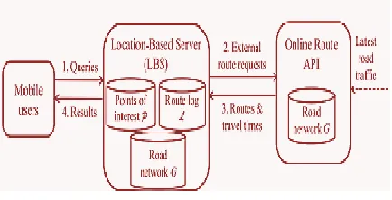
III. THE PROPOSED APPROACH
In this paper, we adoptthe system architecture as
depicted in Fig.1. It consists ofthe following entities:
Fig. 1.System architecture.
Online Route API. Examples are: Google/Bing
routeAPIs [7], [4]. Such API computes the shortest
routebetween two points on a road network, based
onlive traffic [6]. It has the latest road network G
withlive travel time information.
Mobile User. Using a mobile device (smartphone),
theuser can acquire his current geo-location q and
thenissue queries to a location-based server. In
thispaper, we consider range and KNN queries
basedon live traffic.
Location-Based Service/Server. It provides
mobileusers with query services on a data set P,
whosePOIs (e.g., restaurants, cafes) are specific to
theLBS’s application. The LBS may store a road
network G with edge weights as spatial
distances,however G cannot provide live travel times.
In caseP and G do not fit in main memory, the LBS
maystore P as an R-tree and store the G as a
disk-basedadjacency list.
Before delving into the actual AT&T application, it is
critical to assess the two overall areas that contribute
to the quality of results
from any LBS application: the mapping data and the
LBS Engine software (3).
A. Data Capture and Collection
LBS applications typically use information from
several content databases:
The road network (digital maps)Business and
landmark information, often referred to as Yellow
Pages, or POI information
Dynamic data such as traffic and weather reports
B. Digital road databases
Building LBS applications starts with the collection
of road data. The United States alone contains
millions of individual roadsegments. Map database
vendors collect and convert raw geographic content
into digital formats. The map data are captured
inmany ways, ranging from satellite imagery to
Some vendors physically driveeach road segment in
GPS-equipped cars, recording every change of
direction and photographing road signs to keep track
ofspecific road conditions such as turn and
height/weight restrictions.
Each vendor's data are different, which accounts for
some of the discrepancy in the maps and routes
generated(19). Some data are
extremely accurate but have only partial coverage.
Some vendors provide complete coverage but have
data with positioning errorsand geometry
problems.Map data are stored in a vector format
composed of line segments (links) representing the
roads and connecting points representingintersections
or other road features. Each link has start and end
points and may also incorporate shape points to
model the curvatureof the road. In addition to
geometry, the data contain feature attributes such as
one way streets, exit signage, prohibited turns
andmaneuvers, vehicle-height restrictions, bridges,
tunnels, and street addresses.The complexities of
modeling the idiosyncrasies of the road system are
significant. Consider an example such as the Golden
GateBridge in San Francisco. The bridge has
moveable dividers that split the road into one-way
sections in each direction and a sharedlane that
changes direction before morning and evening rush
hours. To model this system accurately, a vendor
needs to doubledigitize the shared lane and flag the
lanes with time-of-day restrictions for closures. Or
consider the challenge of the Europeanroundabout or
traffic circle. Each road meeting at the circle is
typically two-way, but the circle permits travel in
only one direction.
C. Point-Of-Interest Information
One of the most popular LBS applications is Yellow
Pages, or concierge services. Mobile concierge-type
services help users locatebusinesses near a specified
location. These services help answer questions such
as, "Where is the airport?" "Where can I find
aChinese restaurant?" or "Where is the nearest gas
station?" Some services will even make hotel or
dinner reservations, orderflowers, and coordinate
other fetch-and-get tasks. Concierge applications use
business and landmark information that has
beencompiled into POI databases. Integrating the
map database with the POI database creates a
detailed, digital representation of theroad network
and business services available along it.
These POI databases contain the kind of detailed
information typically found in a phone directory and
add value to the mapdatabase's geographic content
(5). As is the case with a map database, POI
databases collected from multiple vendors can be
mergedto form a single, comprehensive data set.
Each record in an individual POI database is
geocoded, or assigned a latitude/longitudecoordinate,
before being combined with other POI databases.
After multiple POI databases are integrated, the
resulting "super" POIdatabase is indexed and each
record is assigned a unique identifier so that it can be
associated to a link in the map database.
In addition to permitting the merge of multiple POI
data sets, some LBS technology providers let vendors
add their own unique POIinformation to the data set.
For example, retail corporations can have store
locations digitized, allowing prospective customers
tosearch for the stores closest to them. This allows
LBS application developers to contribute unique
value to the data and/or to addressspecific vertical
Integrating the map database with the POI database
yields a detailed, digital representation of the road
network with the accuracyand coverage necessary for
high-quality LBS. Some providers, in the rush to get
to market, have not taken stringent steps toguarantee
the quality of their map databases. Although some
vendors handle conflation using rigorous techniques
such as SelectiveArea Merging, many rely on
haphazard, manual data-integration methods that
result in inaccurate and incomplete product
offerings.Only providers who use high-quality data
and data Applications.
IV. CONCLUSION
In this paper, we propose a solution for the LBS
toapproach range/KNN queries such that the
queryoutcome have correct journey occasions and the
LBSincurs few quantity of route requests. Our
solutionRoute-Saver collects up to date routes bought
froman online route API (within d minutes). For the
duration ofquestion processing, it exploits these
routes to derive amazing scale down-upper bounds
for saving routerequests, and examines the candidates
for queriesin an potent order.We have additionally
studied the parallelization of routerequests to
additional shrink query response time. Ournalysis
suggests that Route-Saver isthree times more
efficient than a competitor, and yetachieves excessive
effect accuracythod.
REFERENCES
[1] M. Arjun and K. Sirisha, “Live Activity List Based Shortest Path Calculation”, IEEE, Vol. 2,No.9,
2015.
[2] R. Subashini and A. Jeya Christy, “Online
Shortest Path based on Live Traffic Circumstances”
Vol. 3, No.11, 2014.
[3] Dekonda Sindhuja, R Vasavi and A Kousar
Nikhath, “Online shortest path computation using Live Traffic index”, Vol. 25, No. 3, 2015.
[4] D. Papadias, J. Zhang, N. Mamoulis, and Y. Tao,
“Query processingin spatial network databases,” in
Proc. 29th Int. Conf. Very LargeData Bases, 2003,
pp. 802–813.
[5] H. Samet, J. Sankaranarayanan, and H. Alborzi,
“Scalable networkdistance browsing in spatial databases,” in Proc. ACM SIGMODInt. Conf.
Manage. Data, 2008, pp. 43–54.
[6] Y. Sun, T. La Porta, and P. Kermani, “A flexible
privacy enhancedlocation-based services system
framework and practice,” IEEETrans. Mobile
Comput., vol. 8, no. 3, pp. 304–321, Mar. 2009.
[7] Chunlin Jiang, Weijia JIA and Ke GU, “An
Anonymous WirelessAuthentication Protocol Based
on Proxy Signature”. Trans. 2012.
[8] C.Y Chow, M.F.Mokbel, and T. He, “A
privacy-preserving locationmonitoring system for wireless
sensor networks,” IEEE Trans.Mobile Comput., vol.
10, no. 1, pp. 94–107, Jan. 2011.
[9] Jeppe Rishede Thomsen Man Lung Yiu,
“Effective Caching ofShortest Paths for Location-Based Services”.
[10] Femi Olumofin, Piotr K. Tysowski, Ian
Goldberg, and UrsHengartner Achieving Efficient
Query Privacy for Location BasedServices
[11] R Larajenifer, E Priyanka, M Suganya and R
[12] Haibo Hu, Dik Lun Lee, and Jianliang Xu, “Fast Nearest NeighborSearch on Road Networks”
Author’s Profile
Mr.A.RAMESHBABU was born in India in the year
of 1978. He received M.sc (Computer Science) in the
year of 2003 from K.U. He was expert in Database
Management Systems, M.F.C.S, D.A.A,
InternetTechnology and Linux programming
currently working as An Associate Professor in the
CSE Department in Vaagdevi College of
Engineering, (J.N.T.U), UGC Autonomous,
Bollikunta, Warangal, Telengana State, India.
Mr.K.NARESH was born in India. He is pursuing
M.Tech degree in Computer Science & Engineering
in CSE Department in Vaagdevi college Of
Engineering, Bollikunta, Warangal Dist Telengana