
International Journal of Emerging Technology and Advanced Engineering
Website: www.ijetae.com (ISSN 2250-2459,ISO 9001:2008 Certified Journal, Volume 4, Issue 2, February 2014)
Management of Parking Guidance Information System based on
WSN
Divya jyoti
1, Prof. Sharad wagh
21,2Depatment of Electronics And Telecommunication, Mpstme, Nmims, Mumbai
Abstract-To cope with the ever growing problem of traffic and parking management this paper proposes an automated guidance and management for user to park the car. The nodes transmit the information through wireless sensor network by tree-like topological structure using ZigBee. After analyzing and processing the data, the information and Management center would distribute the parking information by LED screen and displays for the drivers andthereby reducing the time for the driver to find vacant space and almost reduce the chances of entering into the unusual space which might lead into the traffic jam.
Keywords—Wireless Sensor Network(WSN); Parking Guidance and Information System (PGIS); ZigBee
I. INTRODUCTION
During last two decades, the parking problem in big cities, especially the mega-cities, has become one of the key causes of the city traffic congestion. The Parking Guidance and Information System (PGIS) are considered to be an effective way to improve parking situation. Wireless Sensor Network (WSN) technologies has attracted & increased attention and are rapidly emerging due to their enormous application potential in diverse fields. This buoyant field is expected to provide an efficient and cost-effective solution to the efficient car parking problems have taken a lot of the guesswork out of driving: Wireless sensor network (WSN) consists of a large number of low cost sensor nodes which are deployed in the sensing area. These nodes can form a multi-hop ad-hoc network by wireless communication. They can sensor, sample and process the information gathered from the sensing area, and transmit it to the observer. WSN can be applied to many fields such as environment monitoring, intelligent transportation, smart home and so on [1].
Unfortunately, there are only a few of the parking lots have applied the PGIS whose way of transmitting information is usually based on RS-485 bus. However, it is not so convenient for the current parking lots to be equipped with the cabled-based PGIS, because the reconstruction encumbers the operation of the parking lots.
Furthermore, most of the nowadays parking lots only control the entrance and exit of the parking lots, which can only know the whole number of the available parking spaces in the parking lots, and ignore the management of the parking spaces and the parking Guidance for drivers inside the parking lots. WSN for PGIS is presented to solve this problem. WSN-based PGIS can be designed more freely without much change on the existing building, and can be easily compatible with the existing PGIS.
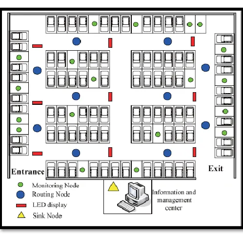
In the PGIS, there are three kinds of nodes, which are monitoring nodes, routing nodes and sink node. Those nodes communicate with wireless channel, and self-organize into an ad-hoc network. The monitoring nodes would detect the status of every parking space, and transmit the information through routing nodes hop by hop to the sink node. The sink node connects to the information and management center through RS-232 interface. After processing the data, the information and management center will send the message to all the nodes and update the information in LED screen at the entrance of the parking lot.
For the new-coming car, PGIS will calculate an optimal parking space according to the behave of the drives, and show the path to the parking space in the LED screen at the entrance, and the LED displays at the main turnoffs of the road inside the parking lot which will notice the driver at the same time. So that the drivers can enter the parking lots and spends less time on looking for the parking space. The PGIS can help the drivers to park their cars quickly and safely [2].
International Journal of Emerging Technology and Advanced Engineering
Website: www.ijetae.com (ISSN 2250-2459,ISO 9001:2008 Certified Journal, Volume 4, Issue 2, February 2014)
552 II. RELATED WORK
Vipin Kumar verma [7] proposes distributed traffic monitoring and controlling model using sensors and dedicated traffic servers. This model is described as basic role-oriented processes communicating though primitive interaction protocols. The model is aimed to provide an enabling communications framework upon which multi-agent system models can be organized and built to be used for an simulation of an road map and to estimate the traffic behavior (to provide information about the best routes). The model assists the drivers to get the desired destination taking into account the current situation of traffic characteristics. It gives the estimated arrival time and the corresponding distance between a start and an arrival point. The necessary information is obtained from current traffic position using sensors (used as dynamic information and to characterize the traffic, for example if traffic is jammed on an area, we can predict alter paths). The information given by the advisory system has the form of self-generated message according to the condition of traffic using the given algorithm.
Seong-e-yo [6], proposed (DGS), a Driving Guidance System based on wireless sensor networks (WSN) which guides a driver to drive a car in safety. The system consists of two sub-systems: SMS (Speed Measurement system) and WPS (Weather information providing Sub-system). SMS measures the speed of a car and captures the image of the speeding car using a speed camera. WPS provides weather information including the road conditions (icy, wet, etc.) via VMS or a telemetric terminal.
S. V. Srikanth [5],Proposed a Smart Parking (SPARK) Management System which provides advanced features like remote parking monitoring, automated guidance & parking reservation mechanism. Though prototype system, they proposed the architecture which satisfies the car parking management system requirement [4].
Mingkai Chen [1] introduces a parking guidance and information system based on wireless sensor system. This system consists of parking space monitoring nodes, routing nodes, sink node, parking guidance display and an information and management center. The nodes transmit the information through wireless sensor network by tree-like topological structure with non-standard protocol we developed. After analyzing and processing the data, the information and management center would distribute the parking information by LED screen and displays for the drivers. This paper introduces a WSN based on IR sensor nodes which, the customer can plan for their transit to public transportation with such smart parking systems employed at Park and Rides.
Europe, the United Kingdom and Japan were among the first countries to implement parking systems. Today we can find several smart parking facilities in most major cities. Smart parking technology benefits the customer and the parking operator in the following ways:
• The customer can readily determine space availability prior to entering the parking area because of the CSMA/CA mechanism,
• The packets can avoid some collision in the process of transmission; the congestion of network can be controlled, so customers can plan for their transit easily
• The parking operator can use the system data to develop or improve pricing strategies
• The parking operator can use this system data to predict future parking patterns and trends and it is compatible with existing wired network too
• The parking operator can reduce the staffing requirements for traffic control within the facility. The system significantly reduces traffic–and the resulting vehicle emissions– by decreasing the time required for customers to locate open spaces.
[image:2.612.328.577.414.656.2]III. SYSTEM ARCHITECTURE
Fig 1.Architecture of PGIS
International Journal of Emerging Technology and Advanced Engineering
Website: www.ijetae.com (ISSN 2250-2459,ISO 9001:2008 Certified Journal, Volume 4, Issue 2, February 2014)
After the car parked in the parking space, the monitoring node will detect the status in a short time and transmit the data to the sink node. The sink node would notify the information and management center the change as soon as it receives the message. The center would re-calculate the guiding information and show it in LED screen.
There are three parts in PGIS: sensor nodes, LED display, and information and management center. In this system, the information and management center is the key part of PGIS, which control the whole system and is installed in the monitoring room. The WSN in the parking lot contains three kinds of sensor nodes, which are monitoring nodes, routing nodes and sink node. In addition, the LED displays are installed at the main turnoffs of the roads and the LED screen is installed at the entrance of the parking lots. The architecture of PGIS is shown in Fig. 1. system consisting of IR sensor, controller, LED screen and interfacing screen.
The functions of the devices in the PGIS are as follows:
A. Monitoring node
The monitoring nodes are installed upon or aside of every parking space. The node detects the status of parking space with ultrasonic and transmits message by RF communication module. It also receives commands from information and management center to carry out some procedures.
B. Routing node
The routing node receives data from monitoring nodes and transmits it to sink node hop by hop with tree-like topology. It also transmits the commands from information and management center to all the monitoring nodes.
C. Sink node
The sink node is installed in the monitoring room. It collects the information of the parking spaces and delivers it to the information and management center. It connects to the information and management center through an RS-232 interface. The node acts as the gateway between WSN and networks outside.
D. LED display
There is a large LED screen at the entrance of the parking lot to tell the new-coming car the available parking spaces in this parking lot and show the path to the optimal parking space according to the result by the optimal parking space choice model [3] from the PGIS. In addition, there are some LED displays at the main turnoffs which help the drivers to find the optimal parking space with less time.
E. Information and management center
The center takes the charge of managing and maintaining of the whole system. It processes the data from the monitoring nodes, calculates the optimal parking space for the new-coming car, counts the parking fee and controls the LED screen and displays. The center also sends commands to the nodes and controls the whole network
IV. DESIGN NETWORK
A. Network Architecture
Network communication plays an important role in PGIS. It consists of the implementation of communication software module and some important function modules such as integrating embedded system, formatting the networks and so on. As a result, the architecture of network communication protocol is the function core of the whole sensor networks [3].The architecture of the system is shown in Fig.2. There are two parts in the network, they are sensor nodes and information and management center.
Fig2. Topology of WSN
B. ZigBee Protocol
International Journal of Emerging Technology and Advanced Engineering
Website: www.ijetae.com (ISSN 2250-2459,ISO 9001:2008 Certified Journal, Volume 4, Issue 2, February 2014)
554 Fig3.Architecture of wireless communication protocol
1) Physical layer
Physical layer define the interface between physical wireless channel and MAC layer, and provide data service and management service. Physical protocol is based on the hardware of the communication. In this system, we employ radio frequency chip, designed for operation in the world wide ISM frequency band at 2.400 GHz,
2) MAC layer
MAC layer implement the transmission of data framer between equipment’s based on the service from physical layer. MAC layer provide data service and MAC sub-layer management entity [12].In this system, we employ scheduling based MAC protocol. In this MAC protocol, the time slot that every node can transmit data is determined by a certain time slot scheduling algorithm. The emulative MAC protocol employ carrier sensing multiple access/collision avoidance (CSMA/CA) to deal with hidden and exposed node problem. The tree-like topological structure in PGIS employs CSMA/CA to implement the data transmits and control in MAC layer. The key part of MAC layer is the implement of CSMA/ CA mechanism. In addition to CSMA/CA mechanism, there are acknowledgement mechanism to ensure the integrity of data transmission and frequency to ensure the stability of wireless transmission.
C. Framework of Information Management Center
Information management center consists of four modules. They are information acquisition module, information processing module, information issue module and management module. The framework is shown in Fig4 [2]
Fig4. The framework of the information and management center
The functions of the modules in the information management center are as follows:
A) Information acquisition module
The main function of this module is gathering the real-time information of the parking lots. And then transfer it to database of the center. It ensures that the data source for the processing and issue is reliable. The information includes the plate number of the car enter the parking lots, the time when a car enter and exit the parking lot, and the status of the parking space.
B) Information processing module
The information processing module will process the data in the database of the center. After the operation on this data, we can get the information to issue. And when a car is entering the parking lot, the module will provide an optimal parking space for the driver by an optimal parking space choice model based on the status of the parking space, and it also provide the path to the optimal parking space. The vehicle flow of the parking lot will be calculated at the same time.
C) Information issue module
International Journal of Emerging Technology and Advanced Engineering
Website: www.ijetae.com (ISSN 2250-2459,ISO 9001:2008 Certified Journal, Volume 4, Issue 2, February 2014)
There is LED screen issue the available parking spaces at the entrance of the parking lot. The LED displays also show the guiding information at the main turnoffs inside the parking lot, which can help the drivers to find the optimal parking spaces with less time. The system will also transfer the information of the parking lot to the urban parking guidance and information center.
D) Management module
The data of the parking lots, the user’s information and the administration authority are all manage by this module.
[image:5.612.43.297.272.604.2]V. COMPARISON WITH OTHER SYSTEMS
Table 1
Comparison of different parking system [4]
Parking Methods
Ye
Possibility to detect different
types of object s
Type of
sensor used Use of central
Server
Vehicle counting System[8]
Yes Optical
Sensors
Yes
Car parking management
System[9]
No Light
Sensors, Acoustic Sensors &
Magnetic Sensor
Yes
VDS[11] Yes ,Magnetic
Sensor
No
PGI[10] Yes Loop
Detectors No
PGS[5] Yes T -Sensor,
T-sink, T- BS Yes
PGIS using WSN
Yes Ultrasonic
Sensors , IR Sensors
Yes
VI. CONCLUSION
This paper introduces a WSN based on IR sensor nodes which, the customer can readily determine space availability prior to entering the parking area because of the CSMA/CA mechanism, the packets can avoid some collision in the process of transmission, the congestion of network can be controlled.
The customer can plan for their transit to public transportation with such smart parking systems employed at Park and Rides The parking operator can use this system data to prevent vehicle thefts The parking operator can reduce the staffing requirements for traffic control within the facility. The system significantly reduces traffic–and the resulting vehicle emissions– by decreasing the time required for customers to locate open spaces.
REFERENCES
[1] Sun Liming, Li Jianzhong, Chen Yu, Zhu Hongsong. Wireless SensorNetworks. Beijing: Tsinghua University Press, 2005.. [2] Mingkai Chen, Tainhai Chang, “A Parking guidance & Information
system based on Wireless Sensor Networks”, IEEE International Conference on information & Automation Shenzhen, China, June 2011
[3] Mingkai Chen, Chao Hu and Tianhai Chang. “The Research on Optimal Parking Space Choice Model in Parking Lots”. 2011 3rd International Conference on Computer Research and Development, March 11 - 13, 2011, Shanghai, China,Vol. 2, pp:93-97
[4] Satish .V.Reve and Sonal Choudhri ,“Management of Car Parking System Using Wireless Sensor Network”, International Journal of Emerging Technology and Advanced Engineering.ISSN 2250-2459, Volume 2, Issue 7, July 2012
[5] S. V. Srikanth, Pramod P. J., Dileep K. P., Tapas S., Mahesh U. Patil, Sarat Chandra Babu N, “Design & Implementation of a Prototype Smart Parking(SPARK) System using Wireless Sensor Networks” International Conference on Advanced Information Networking & Applications workshops, 978-0-7695-3639-2/09, 2009 IEEE.
[6] Seong-eun Yoo, Poh Kit Chong, Taehong Kim, Jonggu Kang, Daeyoung Kim, Cahngsyb Shin, Kyungbok Sung, Byungtae Jang,“PGS: Parking Guidance System based on Wireless Sensor Networks”, 978-1-42441653-0/08, 2008 IEEE.
[7] Vipin Kumar Verma, Rahul Chaudhari, Siddharth Kumar Singh, Tapas Mishra, Pankaj Srivastava , “Intelligent Transport Management System using Wireless Sensor Networks”, IEEE Intelligent Vehicle Symposium Elndhoven University of technology Elndhoven, Netherlands, June 4-6, 2008.
[8] Jatuporn Chinrungrueng, Udomporn Sunantachaikul, Satien Triamlumlerd, “Smart Parking: An Application of Wireless Sensor Network”, International Symposium on Applications and Internet Workshops (SAINTW07), 978-0-7695-2757-4/07, 2007 IEEE. [9] Rakesh Kumar, Naveen K Chilamkurti, Ben Soh, “A Comparative
Study of Different Sensors for Smart Car Park Management”, International Conference on Intelligent Pervasive Computing, 2007”, 978-0-7695-3006-0/07, 2007 IEEE.
[10] S. Shaheen, C. Rodier, and A. Eaken, “Smart parking management field test: A bay area rapid transit (bart) district parking demonstration”, Jan 2005. Final Report.
[11] Yaser E. Hawas and Marc Joseph B. Napenas, “Infrastructure less Inter-Vehicular Real-Time Route Guidance”, Proc. 11th International IEEE Conference on Intelligent Transportation Systems, 12-15 Oct 2008, pp.1213-1219].
[12] IEEE, IEEE 802.15 WPAN™ Task Group 4:
![Table 1 Comparison of different parking system [4]](https://thumb-us.123doks.com/thumbv2/123dok_us/8719125.883709/5.612.43.297.272.604/table-comparison-different-parking.webp)
