COMPARATIVE STUDY OF POSITION BASED ROUTING
PROTOCOLS IN VANET
Sanjay Batish, Manisha Chahal and Sanjeev Sofat CSE Department, PEC University of Technology, Chandigarh, India
E-Mail: [email protected]
ABSTRACT
Vehicular Ad hoc Network (VANET) is very promising technique to increase traffic safety. This will help in saving life of many people from road accidents. VANET uses vehicle to vehicle communication to inform about the location of other vehicles and the traffic density. There are many routing protocols described in VANET. Position-based protocols are best suited in highly dynamic topology environment as followed by VANET. We will compare various position-based protocols on bases of various parameters. The advantages and limitations of these protocols are also discussed. We also summarized some protocols, which consider real time communication traffic and compare them with other well known position based protocols.
Keywords: VANET, position-based routing protocols.
INTRODUCTION
To overcome the road accidents and handle vehicular run of a particular area, computer networkers purpose a new networking idea i.e. Vehicular Ad hoc Network (VANET). It is highly reliable and efficient. VANET is subset of mobile Ad hoc network in which vehicle operate as a node. It has own distinct characteristics [1] such as dynamic network topology, unbounded network size, frequently disconnected network, Unlimited battery power and storage, road pattern restrictions and time-sensitive data exchange. Some characteristics impose challenges [2] such as network management, environmental impact, MAC design etc. It provides recent information of traffic, node to node communication or node to road side infrastructure communication through wireless network. The real time traffic never has a fixed pattern, so the topology of VANET keeps on changing which makes it a highly dynamic network. The dynamic nature makes it a combination of very lager quantity of users and there is no restriction on the user which comes in the network or leaves the network.
The transmissions strategy may be of three types: unicasting, broadcasting, multicasting which are having their individual’s strength and weaknesses. Unicast strategy takes less network space to deliver the massage and due to less packet delay, it is more secure. But there are chances of packet loss which makes it less reliable. Broadcasting is comparatively more reliable but it consumes high bandwidth, having very low throughput. There are chances of packet collision and routes loop. Multicasting is having the advantage of both unicasting and broadcasting. In view of some of the researches broadcasting is better because the information in VANET should go to everyone in the network. If the problem of bandwidth arises we have to switch to multicasting. Still if the users in the network are very large so we have to select unicasting. Routing protocols are used to provide best possible route between nodes with less overhead. For communication, vehicle exchange message with another
vehicles using radio range signals with bandwidth of 5.850-5.925 GHz.
VANET Routing Network
The VANET routing network gives a highly secure network which helps in reducing the road accidents and deals with the emergency situation. VANET routing is possible by two means: inter-node transmission (INT) and node to road side infrastructure transmission (NRT). In INT routing is between vehicles only, this systems doesn’t require any external infrastructure-free onboard units are sufficient for communication. In NRT systems the communication is between vehicle to vehicle and vehicle to road side infrastructure. It is more reliable but require extra infrastructure.
Routing Protocols in VANET
Routing protocols provide route between two nodes via minimum overhead and without delay. As shown in Figure-1, routing protocols are categories into two types: topology-based and position-based routing (or geographic routing).
Topology-based Routing Protocol
Topology-based routing protocol uses link knowledge of each node present in routing table, and this knowledge is used to send packets. It requires the IP addresses of the source and the destination. It commonly categorized into three categories Proactive (periodic) e.g. DSDV [3], Reactive (on-demand) e.g. AODV [4], and Hybrid.
Proactive (table-driven)
Routing information is always maintained regardless of communication requests. It is time dependent i.e. the information is delivered after a certain period of time.
Reactive (On Demand)
It establish a route only when a node in network require to exchange message with different node. It stores only the currently used paths and all other routes are standby routes which acts as active nodes as and when demanded.
Hybrid
It is the combination of both reactive and proactive. The routes which are having more weight are updated along with the active routes after a certain period of time or on request. Some of the researchers have also used road to road communication rather the vehicle to vehicle communication because the vehicle are having very high speed so the system have to respond very fast.
Position or Geographic Routing protocol
Position based routing protocols requires the moving nodes knowledge through the GPS system, which is based on location services. Geographic routing protocols consider the position of the nodes in routing process. They requires the information of the neighbors location and the location of the target node to send packets successfully. When the source has the data to send it identifies its neighbor nodes within its communication range. The packet header releases from source node contains the position of the target node, speed of the moving vehicle, direction and current time. In this types of protocol there is no need of route detection and route repair, and knowledge of associated topology. Thus geographic based routing protocols are more suitable in highly mobile environments and thus more reliable for VANETs [5].These are categories into three types:
Delay tolerant network (DTN) protocols
In DTN all nodes are connected in series and help each other to forward packets. Data transmission between these nodes have large delay due to limited transmission range. It may also be possible that during transmission the signal may be lost because of series connection of the nodes.
Non delay tolerant network (NON DTN) protocols In NON DTN node deliver its packet to the node which is closest to targeted node. It does not take a disconnectivity problem. It presumes that there are sufficient number of nodes to get the unbeaten transmission. NON DTN is always used in dense network area.
Hybrid position based routing protocol
It is a combination protocol that takes benefit of both.
Position-based Routing Protocols
Unlike topology-based protocols, position-based protocols do not maintain routing table, do not require link state information, they are vigorous and suitable to the highly changing environments like VANETs. In position-based protocols, packet forwarding is position-based on geographic position of a vehicles and they require position services to find the location of the target node. There are many location services available like Global Position System (GPS) [6]. Every node frequently sends Hello or beacon packets with their location knowledge and other node recognition parameters [5] as shown in Figure-2.
ID Location Speed Current time Direction
Figure-2. HELLO packet format.
When wireless network become congested Beacon packets introduce overhead for managing the list of neighbors and reduce the overall performance of the network. To overcome this problem, alternate approach is used called as beaconless dispersed receiver-based selection of next node [5]. This technique uses modified version of request-to-send and clear-request-to-send method. In this process, request frames contain the position of the sender and destination node. Each node wait for a given time in request frame, after completion of this time, it will forward a clear frame back to the sender node. There are some of examples of position-based routing protocols.
(a)
(b)
Figure-3. GPSR protocol (a) Greedy forwarding working, (b) Greedy forwarding fails.
Geographic Source Routing (GSR) protocol
This protocol overcome the limitation of GPSR in urban environment. It uses location information about each node and static street map to compute route to destination. Dijkstra's shortest route method is used to locate the shortest path from source to destination node [8]. Particular node send packet to its next junction node. To compute shortest path junction IDs are used, along which packets should be moved to reach the destination. Packet header sent by source contains list of junctions. This protocol does not work efficiently in sparse network and accessibility of street map is mandatory [8].
Greedy Perimeter Coordinator Routing (GPCR) protocol
It makes routing decision by considering only street and junctions rather than individual node. In GPCR, natural planar graph is formed by junctions and streets. Nodes located at the junction are called as coordinators [8]. Source node will deliver packet to one-hop neighbor, then current forwarding node send packet on the junction (see Figure- 4). If no node is found at the junction, the packet is delivered beside the street for the next junction. When a packet reaches a coordinator, it decides about route of the packet. Therefore, this protocol uses greedy mechanism similar to GPSR. In recovery approach [9], packets go into reverse in a greedy way to a coordinator to locate different solution to return to the greedy mode. This
node density. If node density is low, it could not connect destination, then transmission delay increases.
Figure-4. GPCR routing mechanism- In this scenario c1, c2, c3 are coordinators. Firstly source node sends packet to
one-hop-neighbor, then current forwarding node send packet at junction i.e. c1. This process will continue until
packet reach at destination.
Border-node based Most Forward within Radius (B-MFR) Protocol
It uses the idea of border node. Border nodes present at the edge of the radio transmission range (e.g. DSRC- Dedicated short-range communications) of a node. This method uses border node avoiding use of interior node for utilization of bandwidth. This protocol consists of two steps: neighbor innovation and border node selection method [10]. In the neighbor innovation process, each node collect current one-hop neighbor information by periodic beaconing of Hello packets. Under border node selection method, select the one which is maximum towards the destination by taking the projection of border node on a straight line between sender and destination (see Figure-5(a)). In this protocol, confliction arises (see Figure-5(b)) if two or more border nodes project on a straight line between sender and destination node. It does not support real -time communication traffic.
Figure-5. (b) B-MFR limitation.
Intersection-based Geographical Routing Protocol (IGRP)
This protocol is suitable for dense traffic environments. It considers efficient selection of road joints along which a packet travels to arrive at at the gateway. Vehicles have access to a digital map (e.g. MapMechanics [11], SmartView [12]) to find the location of its neighboring road intersections. Internet gateway gives information to source node to pass on a packet to gateway. Each moving node gives its present information to the gateway when it goes out of its communication range. Internet gateway build different set of paths between itself and each node. To raise intermediate node's constancy, IGRP makes paths by considering adjacent road joints toward the gateway. These paths are called as backbone paths [13] as shown in Figure-6, which are located as succession of joints. Based on these backbone routes, the Internet gateway will choose the most linked route. Source node receive selected path and store it in packet headers. Intermediate nodes forward packet to next node by using information located in packet header. IGRP achieves better performance, selects routes that are highly connected and assures less end-to-end delay.
Figure-6. VANET routing using IGRP- There are three backbone routes to reach the destination, i.e., B-C-F,
A-D-E-F or A-B-E-F. In this network, internet gateway selects the A-B-E-F path since it is containing dense
traffic.
Road-based using Vehicular Traffic (RBVT) Routing protocol
It uses real-time communication traffic. Geographic forwarding as mention in above protocols does not perform well in city scenario. Recovery strategy of most of the geographical routing protocol include planar graph traversals [15], which are ineffective high node mobility, road obstacles etc. This protocol adapt itself to network situations by associating actual vehicular traffic information and route constancy. There are the two types of RBVT protocols: RBVT-R (RBVT-reactive protocol) and RBVT-P (RBVT-proactive protocol) [16]. In RBVT-R, source node send route demand packet to each node, whose header includes all necessary information related to source and destination node. On receiving the route demand packet, destination node will generate route reply packet for source node by coping route demand header into route reply header. For route maintenance, node will convey the route update (RU) packet. RBVT-P store the graph formed by generated packets in periodic way along the road. This graph is then dispersed to all vehicles in the network and further used to find the shortest paths to destination node.
Figure-7. RBVT-R working- (a) Source node broadcast route demand packet with improved flooding mechanism.
Packet will store the traversed intersections in its header when it moves along the street. (b) The destination node unicasts a route reply packet back to the source. Route reply packet takes the route along the intersections stored
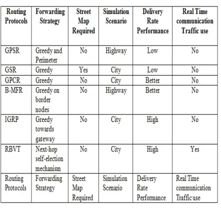
Table-1. Comparison of VANET routing protocols discussed.
CONCLUSIONS
Various routing protocols such as GPSR, GSR, GPCR, B-MFR, IGPR, RBVT have been compared on the basis of the requirements and performance (as shown in table 1). Protocols like GSR requires extra agency like street map. For highway traffic we have GPSR, B-MFR, as routing protocols, out of these BMAR is best suited because of high delivery rate but it require street map for communication. For city traffic GSR, GPCR, IGRP, RBVT routing protocols can be used. IGPR and RBVT both have high delivery rate but RBVT is preferred over IGPR because in RBVT the real time communication between the traffic is used.
REFERENCES
[1] Sherali, Ray Hunt, Yuh-Shyan, Angela Irwin and Aamir Hassan. 2013. Vehicular ad hoc networks (VANETS): status, results, and challenges: IJCNIS.
[2] Ram Shringar Raw, Manish Kumar and Nanhay Singh. 2013. Security Challenges, Issues and their solutions for VANET: IJNSA.
[3] C.E. Perkins and P. Bhagwat. 1994. Highly dynamic destination sequenced distance-vector routing: ACM SIGCOMM.
[4] C. E. Perkins and E. M. Royer. 1999. Ad hoc on-demand distance vector routing: IEEE Workshop on Mobile Computing Systems and Applications.
[5] Marwa Altayeb and Imad Mahgoub. 2013. A Survey of Vehicular Ad hoc Networks Routing Protocols: IJIAS, Vol. 3.
[6] Venkatesh A. Indra and R. Murali. 2014. Routing Protocols for Vehicular Adhoc Networks (VANETs): A Review.Journal of Emerging Trends in Computing and Information Sciences Vol. 5.
[7] B.Karp and H. T. Kung. 2000. GPSR: Greedy Perimeter Stateless Routing for Wireless Networks: ACM/IEEE MobiCom, USA.
[8] Huma Ghafoor, Khurram Aziz. 2011. Position-based and Geocast Routing Protocols in VANETs: International Conference on Emerging Technologies.
[9] Baraa T. Sharef, Raed A. Alsaqour and Mahamod Ismail. 2013. Comparative Study of Variant Position-Based VANET Routing Protocols: ICEEI.
[10] Mingliu Zhang and Richard S. Wolff. 2008. Routing Protocols for Vehicular Ad Hoc Networks in Rural Areas: IEEE Communications Magazine.
[11]GB Traffic Volumes, May 2005.
www.mapmechanics.com
[12]SmartView. www.yahoo.com
[13]H. Saleet, R. Langar, K. Naik, R. Boutaba, A. Nayak and N. Goel. 2011. Intersection-Based Geographical Routing Protocol for VANETs: A Proposal and Analysis: IEEE Transaction on Vehicular Technology.
[14]Ram Shringar Raw and D. K. Lobiyal. 2010. B-MFR Routing Protocol for Vehicular Ad hoc Networks: International Conference on Networking and Information Technology.
[15]C. Lochert, H. Hartenstein and J. Tian. 2003. A routing strategy for vehicular ad hoc networks in city environments.
[16]J. Nzouonta, N. Rajgure, G. Wang and C. Borcea. 2009. VANET Routing on City Roads Using Real-Time Vehicular Traffic Informationm: IEEE Transactions on Vehicular Technology, Vol. 58.