IJSRR, 8(2) April. – June., 2019 Page 2768
Research article Available online www.ijsrr.org
ISSN: 2279–0543
International Journal of Scientific Research and Reviews
Implementation of Transportation Plan In The Ncr Region
Gopal Kumar Johari * and Karmjeet Singh Chahal **
*Associate Professor, Guru Ramdas School of Planning,** Professor,Deptt of Architecture, Guru Nanak Dev University, Amritsar.
ABSTRACT
The transportation networks in region influences population distribution, shape of cities, access to markets and thus directly impacts the overall socio- economic development. Since transportation has a pivotal role it is imperative to develop an eco-friendly sustainable and convenient multi modal transportation network so as to improve connectivity, safety and reduce traffic pressure and travel time. So, it can be revealing that transportation is also a meaningful criterion to examine the situation of regional unbalance regarding the process of growth of transportation sector.
The ‘National Capital Regional Plan 2021’, New Delhi aims "to promote growth and balanced development of the National Capital Region" as one by providing efficient and economical rail and road based transportation network along with -integrated land-use patterns to support the balanced regional development. It is also clears the lack of coordination between the various government and non-government agencies which examined that the transportation growth is not occurring as planned manner. The decentralized growth was planned according to the regional plan but the whole development & growth was seen only along the Delhi ( i.e. Ghaziabad, Noida, Greater Noida) and Greater Noida is the extension of Noida which was not the part of the regional plan. There is a slow rate of implementation of various planned projects even within the core sub region of NCT – Delhi. The DFC (Dedicated Freight Corridors) was not also the part of the regional plan. There is a less growth in proposed industrial centers like Meerut and Bulandshahr and roads proposed are not as per the proposals of industrial growth leading to fall in economic activities in regional centers. The present paper is an attempt to examine the NCR Plan prepared and how it has been implemented in sub region of Uttar Pradesh.
Keywords :Transportation, Growth, Regional Development,
*Corresponding author:
Gopal Kumar Johari
Associate Professor,
IJSRR, 8(2) April. – June., 2019 Page 2769
1.1 Traditional Theoretical Approaches to Regional Policy
There are numerous approaches to regional development, each providing a 'lens' through
which one can examine particular issues. These analytic lenses provide us with a way of assessing
policies and programs.
Theoretical approaches are important because they provide explanations as to why and how
particular regional development “problems” emerge. This should inform our policy efforts to address
the problem. This is important in a policy context because our focus is on “policy learning” – How
do small, sub-national peripheral economies respond to the challenge of globalization? And can one
learn something, rather than re-invent the wheel? Theories of regional development policy are ways
of assessing the real world, generating explanations about current practice. These theoretical
frameworks also provide for the opportunity for comparison over time and space, subject to the
limitations of comparative methodology1.It included Central Place Theory which emphasised on
central concentration3. On another hand there is Core Periphery Model which is based on the core
and periphery equilibrium2. Alike this, Growth Pole Theory emphasised on the equal scale of
development on all the spatial poles and Spatial Equilibrium Model express the equal development
process3. These theories enlightened to understand the regional development in a specific manner.
To examining regional planning, as an unbalanced process both sectorally and spatially,
many of the traditional models dealing with spatial variation in levels of development are irrelevant.
Most of our interregional growth models are based on concepts drawn from International Trade
theory4. As a consequence they are dependent on static equilibrium and assume that, given the
relatively free mobility of the factors of production, factor movements tend to bring about an
equalization of income among regions.
1.2 Need of the present study:
Based on the above description one can analyse the transportation growth as a regional
development in the NCR sub- region (U.P).
1. The development process of Transport Sector is according to NCR plan or not.
2. Does development in the region leads to balance development?
1.3 Transportation as a spatial system in NCR Sub-Region (Uttar Pradesh)
NCR Planning Board had prepared a Functional Plan on Transport for National Capital
Region with perspective year 2032 which is an Integrated Multimodal Transport Plan (IMTP) for
NCR5 & 6. The Functional Plan was prepared after review of demand and supply of transport
IJSRR, 8(2) April. – June., 2019 Page 2770
2009. The Plan recommended Integrated Multi-Modal Transportation System for NCR to improve
the mobility of both people and goods. It also recommended systematic development of Transport
System for fast and efficient movement of traffic, particularly for commuter traffic and to achieve
sustainable development of the region. The Plan comprises following components:
Table1 : Major Components of Transportation Plan
1. Regional Rapid Transit System (RRTS) 7. Bus Terminals
2. New Rail Lines 8. Logistic Hubs
3. Regional Mass Rapid Transit System (MRTS) 9. Integrated Freight Complexes
4. Up-gradation of Roads 10. Highway Facilities Centres, and
5. Expressways 11. Airports
6. Bus Transport System
A comprehensive analysis is carried out to understand the existing as well as possible flow of
traffic movement, economic activities within UP Sub-regionThe study is also carries out for existing
status related to traffic and transportation and the various modality of integrated transport functional
planning for NCR (UP Sub-region)7.
The NCR plan has important objectives to improve transport system in U.P Sub-region as:
1. To develop convenient intercity transportation network.
2. To provide free and convenient flow of traffic movement within NCR UP.
3. To reduced traffic pressure in major centers of NCR UP.
4. To provide proper connectivity among cities and between cities with rural centers.
5. To avoid new roads as far as possible to save rich agriculture land of this area.
6. To reduced travel time in NCR UP.
For this, the existing and proposed study of the area is required, which is described in the upcoming section.
1.4 Concentrated Development vs Decentralisation of Development
A comprehensive analysis was carried out to understand the existing as well as possible flow
of traffic movement within UP Sub region of NCR, the effects of on-going as well as proposed mega
projects (that may affect traffic characteristic) in the study part. The study was also carried out for
existing framework related to traffic and transportation and the various modality of Integrated
IJSRR, 8(2) April. – June., 2019 Page 2771
1.4.1 Road Network a) Existing Status
As per the Sub Regional plan (U.P) 2031, the existing road network consists of Expressways,
National Highways, State Highways, Major District Roads (MDR), Other District Roads (ODR) and
Village Roads. According to the base map of 2012, the total road length in UP Sub-region is
14,464.0 kilometres and the road density is 133.31 km/ 100sq km. At present, out of 3,168 villages,
87.85 % of villages (2783 villages) are connected by metalled roads of different hierarchy. There are
two expressways, six NHs and five SHs in UP Sub-region. There are two expressways in the U.P
sub-regions which cater the traffic which are moving to Delhi because these areas are very close to
the Delhi.
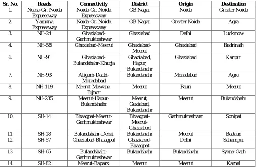
Table 2: Existing Expressways, National Highways (NH) and State Highways (SH)
Sr. No. Roads Connectivity District Origin Destination
1. Noida-Gr. Noida
Expressway
Noida-Gr. Noida Expressway
GB Nagar Noida Greater Noida
2. Yamuna
Expressway
Noida-Gr. Noida Expressway
GB Nagar Greater Noida Agra
3. NH-24
Ghaziabad-Garhmukteshwar
Ghaziabad Delhi Luckmow
4. NH-58 Ghaziabad-Meerut
Ghaziabad-Meerut
Ghaziabad Badrinath
6. NH-91
Ghaziabad-Bulandshahr-Khurja
Ghaziabad, Hapur, Bulandshahr
Ghaziabad Kanpur
7. NH-93
Aligarh-Dadri-Moradabad
Bulandshahr Moradabad Agra
8. NH-119
Meerut-Mawana-Bijnor
Meerut Pauri Meerut
9. NH-235
Meerut-Hapur-Bulandshahr
Meerut, Gaziabad, Bulandshahr
Meerut Bulandshahr
10. SH-14
Bhaagpat-Meerut-Garhmukteshwar
Bhaagpat- Meerut-Ghaziabad
Garhmukteshwar Sonipat
11. SH-18 Bulandshahr-Debai Bulandshahr Meerut Badaun
12. SH-57 Ghaziabad-Bhaagpat
Ghaziabad-Bhaagpat
Delhi Saharnpur
13. SH-65
Bulandshahr-Garhmukteshwar
Bulandshahr Bulandshahr Syana-Garh
14. SH-82 Meerut-Baparsi Meerut Meerut Karnal
Source: National Capital Region Plan (2001-2021)
1. There are six national highways in the U.P sub-regions which caters the maximum traffic of
it.
2. In U.P sub region all metro centers, regional centers, sub-regional centers & service centers
are connected by metalled road. Very few central & basic villages which are not connected
IJSRR, 8(2) April. – June., 2019 Page 2772
3. By-passes and ring roads are available for very few towns which results in mixing of city
traffic with through regional traffic.
4. The physical condition of national highways like NH-91 is poor. Due to improper geometric
alignment of the roads, in many places water logging is observed.On NH-91, vegetable
market, on street parking can be seen commonly.
NCR Plan proposal 2021: The NCR proposals of 2021 includes the up gradation of Old Yamuna Road with upgrade SH and MDR to 60 m wide Green Buffer, Masoori- Bugrasi- MDR to
SH lanning new bridge 30-30 m wide green buffer along both sides of ROW, Daluhera- Hapur – 6
lanning BY-PASS, Naraura- Bulandshahr – SH to NH, Baghpat- sonipat – ODR to SH and Baghpat
– Meerut- SH to NH. It also includes New Roads such as Noida 47 (BY-PASS Road), Khekada-
Delhi (NH-1), Loni- Delhi (NH-1), Baghpat- Delhi(NH-1), Western Expressway and Meerut -
Ghaziabad Expressway . the New By-Pass of Pipeline Road (BY-PASS) and Hapur BY-PASS (NH-
24 to NH-34) is also a part of this development.
b) controlled area. Although Major Roads will interchanges with partial control. The Kundli- Ghaziabad- Palwal Eastern peripheral Expressway and Ghaziabad- Meerut Expressway has been
completed recently in 2019.
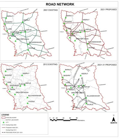
As figure no 1 show facts regarding the level of development such as Yamuna expressway
connect the Delhi-Noida-greater Noida, MDR and ODR connecting the regional centers ,National
highway connecting Ghaziabad-Delhi-Noida is not under the right processing system. There is a poor
connectivity between the metro centers and regional center with NCT. There is only Rail network
IJSRR, 8(2) April. – June., 2019 Page 2773 Figure 1: Road Network in U.P Sub-Region
c) Development as per the NCR plan: As per NCR plan the Eastern Peripheral Expressway
(Kundli-Gaziabad-Palwal) of 86.5 Kms with 6 lane (expendable up to 8 lane in future) is
completed only in 2019. However as per the NCR plan this project needs upmost priority for
bypassing traffic away from Delhi and interlinking Regional centres. The fifteen years delay in
this project effects on desirable result of the Plan and subsequently balanced regional
development.
Apart from this The Ghaziabad – Meerut Expressway – Meerut – Dasna 65 Km is in under progress. There is a development of grid roads within UP Sub-Region between Sonepat-
IJSRR, 8(2) April. – June., 2019 Page 2774
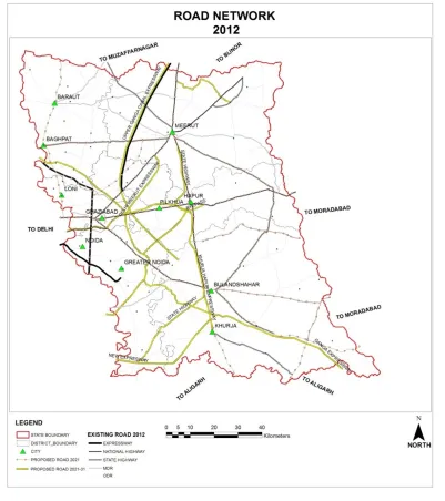
As figure no 2 shows that there is some existing projects such as Golden Quadrilateral Yamuna Expressway connecting the Delhi-Noida-Greater Noida-Agra, State highway and ODR connecting the regional centers are been proposed in revised UP Sub Regional Plan, There is a
less growth in proposed industrial centres like Meerut and Bulandshahar. Roads proposed are not
as per the proposals of industrial growth leading to fall in economic activities in regional centres.
d) Implementation not done as per NCR plan proposals : The Green Buffer Zone along Expressway (Buffer-100 Metres), National Highway (Buffer-60 Metres) and State Highway
(Buffer-30 Metres) is not done as per NCR plan and although, on the Highway Corridor Zone
the 500 m corridor on either side of highwayshas not even started yet.
e) Proposals beyond Sub Regional Plan: The U.P sub-region has many projects on the ground reality but they are not a part of the U.P sub-region plan.
Taj Expressway: - This PPP (Public Private Partnership) project is a 165.5 km access controlled high speed six-lane (expandable to 8 lanes) expressway connecting Delhi with Agra via Mathura.
It has reduced the travel time between New Delhi and Agra.
Development (Road Network) other than NCR plan 2012: There is also an another development which is not a part of NCR plan-2012 this includes the Expressways of Noida
Greater Noida Expressway, Yamuna Expressway- Greater Noida, Ganga Expressway- Greater
Noida- Ballia of 105.5 Km stretch with 110m proposed road high speed 8 lane expressway and
Upper Ganga Canal Expressway- (Purkazi- Sanauta Bridge) of 147.8 Km with High speed 8 lane
corridor. It also include National Highways as NH 24 - Ghaziabad –Garhmukteshwar, NH 58 –
IJSRR, 8(2) April. – June., 2019 Page 2775 Figure 2: Road Network - 2012
Khurja, NH 93 - Aligarh- Moradabad , NH 119 – Meerut – Bijnor and NH 334 – Meerut –
Bulandshahr. The state highway is also aaprt of this development which includes SH 14 – Baghpat-
Garhmukteshwar, SH 18 – Bulandshahr – Debai, SH 57 – Ghaziabad – Baghpat , SH 65 –
Bulandshahr – Garhmukteshwar and SH 82 – Meerut – Baparsi.
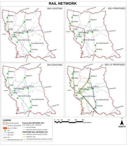
1.4.2 Rail Network a) Existing Status
UP Sub-region is served by a network of rail routes connecting important towns. It also acts as a
transit network for passenger and freight movement between rests of the country. Major rail routes in
the Sub-region are:
IJSRR, 8(2) April. – June., 2019 Page 2776 Delhi – Ghaziabad – Hapur – Moradabad (Double line Electrified)
Delhi – Ghaziabad – Meerut- Saharanpur (Double line, electrified)
Delhi – Shahdara – Shamli (Single line, electrification is in progress)
Meerut- Hapur- Bulandshahr- Khurja (Electrified Single line)
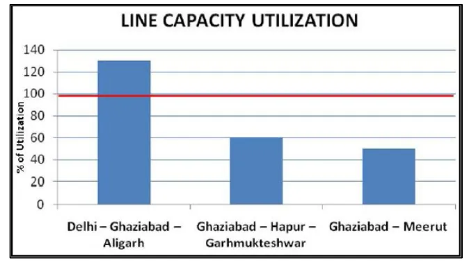
Figure 3: Line capacity utilization of major rail route.
Note: Red line shows the permissible capacity of each Sub-section.
U.P sub-region is served by a network of rail routes connecting important towns. It also acts
as a transit network for passenger and freight movement between rests of the country. In U.P
sub-region 3 rail routes are there, all of them are in different way
a) Ghaziabad-Garhmukteshwar
b) Ghaziabad-Meerut-Muzzafarnagar
c) Ghaziabad Aligarh
In U.P. sub-region, there are 53 railway stations; the maximum number of which is present in
Ghaziabad district (20) followed by Baghpat (12), Meerut (7) and Gautam BudhNagar district (4).
The condition of few stations are good otherwise all of them are in very bad condition.no benches are
provided for sitting, no sheds have created so that people can stand over there in the summers, even
condition of toilets are deteriorated.
Ghaziabad is the most important rail inter -change station as three routes converge here this is
many trains coming from U.P, have to stop first in Ghaziabad and then they headed towards Delhi
Ghaziabad is uses as a freight point of U.P, Delhi as well as whole NCR as shown infigure no. 4.
The existing line capacity has reached saturation in Delhi Area. Further augmentation can be
done in Delhi Area to cater to the current and future demand in the following manner.
1) In terms of freight, U.P sub- region has 4 logistic hubs & 2 inland container depots but they
IJSRR, 8(2) April. – June., 2019 Page 2777
2) Each district of U.P sub-region has industrial units but they are more concentrated
inGhaziabad, Meerut, Noida these three settlement have maximum industries in it even all of
them are having transport Nagar because of D.F.C & DMIC
3) Meerut having logistic hub as well as industries because Meerut population is very much as
compared to other districts within the U.P sub-region.
4) Inward traffic for and beyond UP Sub-region destinations consists of coal for power houses
and industries, fertilizers, cement, iron & steel, containers loaded with imported traffic and
general goods etc.
Presently, goods traffic is given lower precedence and the scope for handling freight traffic
due to congestion at terminals in Delhi area is high.
b) NCR Plan proposal 2021-31: There are NCR plan known as “Functional Plan on Transportation for National Capital Region-2032” which included the Additional parallel lines, Increasing Line
capacity, Orbital rail corroder and Regional Rail Transport System such as DMRC projects of
metro extension to Ghaziabad, Vaishali Ph-III, Greater Noida and Regional mass Rapid Trans
System of Ghaziabad- Meerut, Noida-Greater Noida-Jewar, Ghaziabad-Hapur. The Regional
Rapid Transit System is suggested for 4 corridors for the region 8. Some existing projects which
examine the level of development such as Single line rail network was present in 2001, Orbital
Rail corridor, Regional rapid transit system and double rail was proposed in 2021 plan to increase
the connectivity and fast freight movement as shown in figure 4.
c) NCR plan proposals and their Implementation: According to NCR plan proposals -2021 there will be Green Buffer Zone along rail (Buffer- 30 Meters). The Regional Rapid Transit System
will be connecting with NCT-Delhi and suppose to be completed by 2025. There will be either
lying of two dedicated tracks or strengthening of existing rail network and Orbital Rail corridor
will be connecting GB Nagar, Ghaziabad, Modinagar and Dadri. The Orbital Rail Corridor and
RRTS projects were not implemented till yet, Green Buffer was proposed along the rail line
which was not implemented and Ministry of Railway has given proposal for DFC and DMIC as
shown in figure no. 4.
As figure no 5 shows that laying down of dedicated tracks were not implemented, Orbital rail
corridor and RRTS project were not implemented yet and still there is poor freight connectivity
between the Delhi, Ghaziabad, Hapur, Meerut, Noida and Bulandshahr, Half the portion of the
region is still not yet considered for the rail connectivity yet and DMRC metro project has been
implemented which connecting Delhi-Noida-Greater Noida which was not the part of the NCR
IJSRR, 8(2) April. – June., 2019 Page 2778
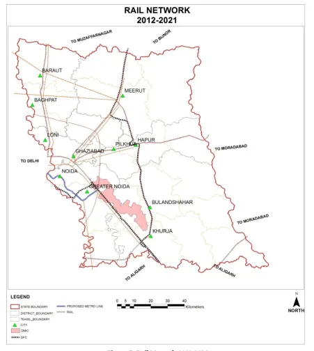
d) Development as per the NCR plan: As per NCR plan there is only doubling of trac ks as parallel tracks is a part of new development.
IJSRR, 8(2) April. – June., 2019 Page 2779 Figure 5: Rail Network 2012-2021
e) Implementation not done as per NCR plan proposals: There is Green Buffer Zone for rail line (Buffer- 30 Meters) is not done as per NCR plan. As figure no 5.Showsthere is weaker rail
network causing a slow freight movement and slow economic growth despite of such big
proposals.
f) Proposals beyond Sub Regional Plan: It includes the following:
Dedicated freight corridor: - The Indian Railways quadrilateral linking the four metropolitan cities of Delhi, Mumbai, Chennai and Howrah, commonly known as the Golden Quadrilateral
IJSRR, 8(2) April. – June., 2019 Page 2780
10,122 km carries more than 55% of revenue earning freight traffic of Indian Railways.The
existing trunk routes of Howrah-Delhi on the Eastern Corridor and Mumbai-Delhi on the
Western Corridor are highly saturated with line capacity utilization varying between 115% &
150%. The surging power needs requiring heavy coal movement, booming infrastructure
construction and growing international trade has led to the conception of the Dedicated Freight
Corridors along the Eastern and Western Routes.
Development (Rail Network) other than NCR plan 2012: It is alsoincluded DMIC (Delhi Mumbai Industrial Corridor) with Feeder Rail Service connecting to eastern and western freight
corridors and DMRC metro project of Delhi-Noida-Greater Noida.
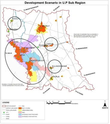
1.4.3 Development Scenario in the U.P Sub Region
As figure no 6reveals that there is Extended CNCR (Central National Capital Regionearlier
DMA- Delhi Metropolitan Area) zone which is beyond the proposal, proposal for the extension of
CNCR according to the growth trends of Ghaziabad, Noida and Greater Noida and Extension of
organisable limit and CNCR are having conflicts taking the plans different directions. Some facts
show the level of development such as proposal beyond the plan by various agencies, Poor
dispersion of these urban settlements, Expansion of organisable limits of the cities and Expansion of
CNCR area limits far beyond the limit. The unexpected high growth of Cities like Greater Noida,
Loni and Ghaziabad, Central level proposals (DMIC, DFC) causing deviation from the plans
changing the perspective of the Sub Regional Plan. This aberration created from the failure in the
projections assumed according to the proposed growth centres and Lack of coordination between the
IJSRR, 8(2) April. – June., 2019 Page 2781 Figure 6: Development Scenario in U.P Sub Region
1.5 Conclusion
The present study focuses on regional disparities in the NCR sub region in U.P and compares
the existing as well as future proposals with the level of development. To have a better understanding
of the issues involved, the present paper has traced government policies on balanced regional
development from the beginning and has also touched on the issue of devolution of resources. This
hopefully will enable a better insight into the problem. The present paper is an extensive discussion
of government policies, a detailed discussion of transportation situation in the NCR sub region in
U.P.
The consensus for a holistic ‘Avoid- Shift- Improve’ transportation paradigm is yet to be
fully realised. The road network is inadequate both in quantity and quality. By-passes and ring roads
are available for very few towns which results in mixing of city traffic with through regional traffic.
IJSRR, 8(2) April. – June., 2019 Page 2782
Baghpat and Bulandshahr is inadequate. Lateral connectivity is not improved in Transport Functional
Plan for NCR 2032 proposal in UP Sub-region. The physical condition of National Highways like
NH-91 is poor.
Apart from these “poor implementation of plan” the major transportation proposals by State
Government like the Ganga Canal Expressway, Ganga Expressway, Delhi- Meerut expressway,
widening of NH-24, Jewar Airport and Meerut Satellite airport have been conceptualised for quite
some time and also form a part of the Transportation Functional Plan but the progress in
implementation of the proposals is quite slow. More particularly, environmental clearance of Ganga
Expressway and Upper Ganga Canal Expressway is still awaited from Government of India. The
delays in execution of these infrastructure projects adversely affect the basic planning of Regional
Plan/ Sub-regional Plan or Master Plan. Besides the funds required for implementation of such
proposals should be released from the Centre expeditiously in order to cater to the rapid urbanisation
in Delhi and NCR.
In their planning process, Indian Railways have not concentrated on regional/ local/ metro
commuter traffic exclusively. The issues of punctuality, reliability of service, comfort, seamless
operation, reduction in waiting time, and physical transfer from one mode to another, and above all
affordability of tariff (or economic viability for the railways) are equally vital in determining the
socially and individually preferred mode of travel.Rail network in many areas are non-electrified
therefore EMU (Electrical Multiple Unit) operation for commuter traffic is not feasible.
Rather, it is an attempt to focus on the issue of balanced regional development which has
been an underlying theme of planning in India. The unexpected high growth of Cities like Greater
Noida, Loni and Gazibad, Central level proposals (DMIC, DFC) causing deviation from the plans
changing the perspective of the Sub Regional Plan. This aberration created from the failure in the
projections assumed according to the proposed growth centres and Lack of coordination between the
authorities or agencies while preparing the master plan and the sub regional perspective not taken in
account. It is an important criterion which detailed out the level of progress of development through
government and non-government agencies.
Acknowledgments
:Modgil, Salil. (2015). Un PPublishedThesis of M.Tech.(Urban Planning): Appraisal of Development in NCR Sub Region - Uttar Pradesh, Guru Ramdas School of Planning,IJSRR, 8(2) April. – June., 2019 Page 2783
REFERENCES:
1. McCall, Tony. What do we mean by Regional Development, Institute for Regional Development,
Cradle Coast campus, University of Tasmania, 2010.
2. Krishan, G. ‘National capital region of India a case of metropolitan growth management’,
Population Geography, 1988;10: 73-91.
3. Kowalewski, S.A. ‘The evolution of Primate Regional System’, Comparative Urban Research,
1982, 9: 60-78.
4. MacLeod, G and Jones, M. Renewing the geography of regions, Environment and Planning :
Society and Space 2001; 19: 669-695.
5. National Capital Region Planning Board (NCRPB). Regional Plan 2001-NationalCapital
Region. Planning Department, Ministry of Urban Development, Government of India, 1988. New Delhi
6. National Capital Region Planning Board (NCRPB), Draft Revised Regional Plan2021:
National Capital Region. Ministry of Urban Development, Government of India, 2013.
New Delhi
7. NCR Planning Cell, Uttar Pradesh. Sub Regional Plan-Uttar Pradesh-2021. Ministry of Urban
Development, Government of Utter Pradesh, 2013.Ghaziabad
8. National Capital Region Planning Board (NCRPB). Functional Plan on Transportation for
National Capital Region-2032. Ministry of Urban Development, Government of India,