Original Citation:
Sentinel-2 Data Analysis and Comparison with UAV Multispectral Images for Precision Viticulture
Publisher:
Published version:
DOI:
Terms of use:
Open Access
(Article begins on next page)
This article is made available under terms and conditions applicable to Open Access Guidelines, as described at http://www.unipd.it/download/file/fid/55401 (Italian only)
Availability:
This version is available at: 11577/3281200 since: 2018-10-14T19:19:57Z
105
Sentinel-2 Data Analysis and
Comparison with UAV
Multispectral Images for Precision
Viticulture
GI_Forum 2018, Issue 1 Page: 105 - 116 Short Paper Corresponding Author: [email protected] DOI: 10.1553/giscience2018_01_s105Frederica Nonni, Diego Malacarne, Salvatore Eugenio Pappalardo, Daniele Codato, Franco Meggio and Massimo De Marchi
University of Padua, Italy
Abstract
Precision viticulture (PV) requires the use of technologies that can detect the spatial and temporal variability of vineyards and, at the same time, allow useful information to be obtained at sustainable costs. In order to develop a cheap and easy-to-handle operational monitoring scheme for PV, the aim of this work was to evaluate the possibility of using Sentinel-2 multispectral images for long-term vineyard monitoring through the Normalized Difference Vegetation Index (NDVI). Vigour maps of two vineyards located in northeastern Italy were computed from satellite imagery and compared with those derived from UAV multispectral images; their correspondence was evaluated from qualitative and statistical points of view. To achieve this, the UAV images were roughly resampled to 10 m pixel size in order to match the spatial resolution of the satellite imagery. Preliminary results show the potential use of open source Sentinel-2 platforms for monitoring vineyards, highlighting links with the information given in the agronomic bulletins and identifying critical areas for crop production. Despite the large differences in spatial resolution, the results of the comparison between the UAV and Sentinel-2 data were promising. However, for long-term vineyard monitoring at territory scale, further studies using multispectral sensor calibration and groundtruth data are required.
Keywords:
Normalized Difference Vegetation Index, remote sensing, precision agriculture
1
Introduction
Precision Agriculture (PA) can be defined as the site-specific, temporal and spatial management of crop heterogeneity, in order to enhance agricultural efficiency and to increase yields, quality and sustainable production (Matese et al., 2015). PA techniques are used in viticulture to manage the vineyards’ variability through Variable Rate Technologies concerning fertilizer and spray applications, and appropriate management practices such as precision pruning and selective harvesting. An essential element in managing vineyard variability is the use of technologies to assess the spatial and temporal heterogeneity of vine growth and vigour at sustainable costs. For these reasons, we evaluated the possibility of
106
using Sentinel-2 multispectral imagery to develop a low-cost, easy-to-handle operational monitoring scheme for Precision Viticulture (PV). Because Sentinel-2 imagery has a coarse-grained spatial resolution of 10 m, the complex but regular row-structured canopy typical of vineyards results in mixed pixels of soil (grass covered) and vegetation, posing challenges when estimating vine-level biomass and vigour (Wang et al., 2017).
One of the most commonly used vegetation indices, the Normalized Difference Vegetation Index (NDVI), was computed to derive vigour maps of two vineyards located in northeastern Italy. The NDVI maps computed from Sentinel-2 imagery were compared with those derived from Unmanned Aerial Vehicle (UAV) multispectral imagery, upscaled from a 2-centimetre resolution to the coarser resolution of the satellite imagery.
2
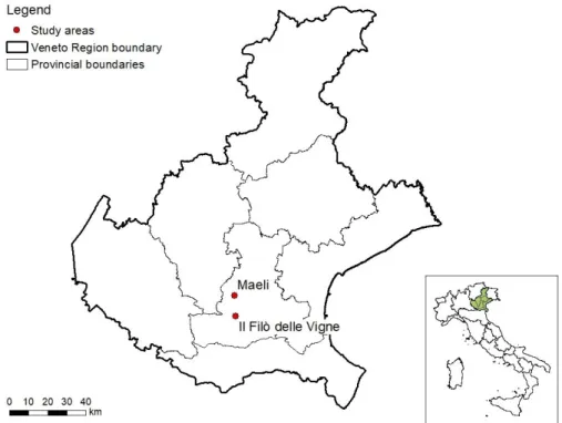
Study areas
The study areas are two vineyards located in northeastern Italy (Figure 1), each of about one hectare of Merlot grape variety, trained as a vertical trellis system. The vines are spaced 0.8 m apart along the rows, and rows are 2 m apart, resulting in a density of 6,250 vines per hectare. Both vineyards are on a calcareous marl soil. Maeli vineyard is located between 160 and 211 m a.s.l., with a slope ranging between 5% and 36% and northeast exposure (Figure 2). The Filò delle Vigne vineyard is located at about 60 m a.s.l., with a slope ranging between 1.6% and 2.1%, faces east, and is equipped with a drip irrigation system (Figure 3).
107
3
Materials and Methods
Two different remote sensing platforms were employed: Sentinel-2 (S2) satellites and the UAV DJI Matrice100. The latter was equipped with a multispectral camera; the spatial resolutions at ground level were of 10 m and 0.02 m respectively for the two platforms. QGIS and ArcGIS software packages were used to calculate the NDVI index and analyse the pixel values.
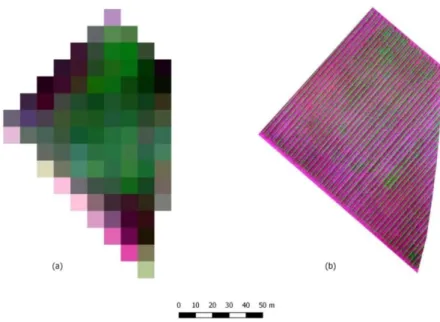
Figure 2: False-colour Sentinel (a) and UAV (b) images, Maeli vineyard
108
Satellite images
Satellite imagery came from the twin Sentinel-2A and Sentinel-2B satellites implemented by the European Commission (EC) and the European Space Agency (ESA) for global land observation within the Copernicus Programme. The two satellites acquire multispectral imagery at a ground spatial resolution of between 10 and 60 m, with a revisit time of up to 5 days. Two spectral bands were used in the current study: band 4 (665 nm) and band 8 (842 nm), with a spatial resolution of 10 m. Sentinel-2A images were acquired for the period 1 April to 31 August 2017, from the beginning of the grapevines’ vegetative cycle to complete grape ripeness. Sentinel-2B images were available only for the period 8 July 2017 to 31 August 2017. Most of the images were acquired at processing level 2A. Atmospheric correction of the level-1C images was carried out using the Sen2Cor processor. Overall, 21 images were available for the selected area during the evaluation period, but due to cloud cover, only 15 and 17 images were used to compute the NDVI maps for the Maeli and Filò delle Vigne vineyards respectively.
UAV Images
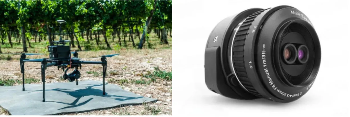
A quadcopter DJI Matrice 100 (Figure 4) equipped with an Agrowing multispectral camera (Figure 5, Table 1) was employed in the present study.
Figure 4: UAV quadcopter DJI Matrice 100 Figure 5: Agrowing multispectral camera
Table 1: Sensor specifications
Mount Sony E-Mount
Sensor APS-C Exmor APS HD CMOS Sensor
Spectral bands 450, 550, 650, 850 nm (B, G, R, NIR) Multi-spectral resolution 8 MP (3550 x 2250 pixels) per colour
channel
for 20.1 MP cameras (QX1 Alpha 5000) Dimensions (Ø x L) 2.3 x 1.3" / 60 x 35 mm
109
ISO sensitivity ISO 100-16000
Shutter type Electronically controlled
Shutter speed 1/4000 s
Table 2: UAV sensing dates
Date Maeli Il Filò delle
Vigne
21/07/2017 √ √
27/07/2017 √ √
04/08/2017 √
08/08/2017 √
Surveys were executed on four different days (Table 2) and the resulting images were used to compute NDVI maps with a spatial resolution of 0.02 m/pixel, according to the following equation (Rouse et al., 1973):
NDVI = 𝑁𝐼𝑅−𝑅𝐸𝐷𝑁𝐼𝑅+𝑅𝐸𝐷
The resulting NDVI maps were further roughly resampled to 10 m pixel size to match the spatial resolution of the Sentinel-2 satellite imagery. The aggregation technique used was the average of the input cells encompassed by the extent of the output cell. It should be pointed out that while the S2 images were acquired at levels 1C or 2A, both with the conversion to reflectance of the Digital Number (DN) values, the UAV imagery was based on DN. The raw index computed using DN can give a good indication of the vegetation conditions, but it is possible that the traditional scale range of the index is affected by certain modifications of the values (Candiago et al., 2015).
4
Results and discussion
Trend of the NDVI average value from satellite imagery
The trend of the NDVI average value from S2 imagery (Figure 6) was analysed according to the agronomic bulletins of the Veneto Region for the period April to August 2017. The initial increase of the NDVI index was associated with an early bud-break recorded in 2017. On the other hand, the decrease in NDVI which followed in both vineyards was probably associated with the heavy frosts that occurred around 19–20 April, which damaged the grapevines’ new shoots. The lack of data availability for the period immediately after this prevents relating the NDVI data with the specific situations of the vineyards, for both the flowering and the fruit-setting stages. In the grape-ripening period, between July and August, a slight decrease in the mean value of the index is seen, revealing a slowing-down of the vines’ growth. From the end of July onwards, an irregular NDVI trend could be related to many causes – not just the phenology of the plants, but also such things as the presence of herbaceous vegetation in the inter-rows, management operations carried out inside the
110
vineyard, and local climatic conditions, in particular the drought conditions and high temperatures recorded during the period.
Figure 6: NDVI average values from satellite imagery
Trend of the NDVI value from satellite imagery seen in single pixels
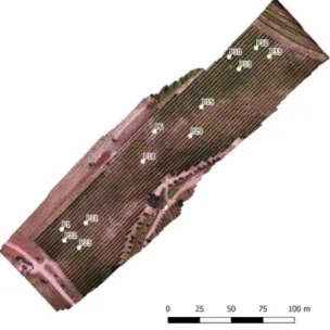
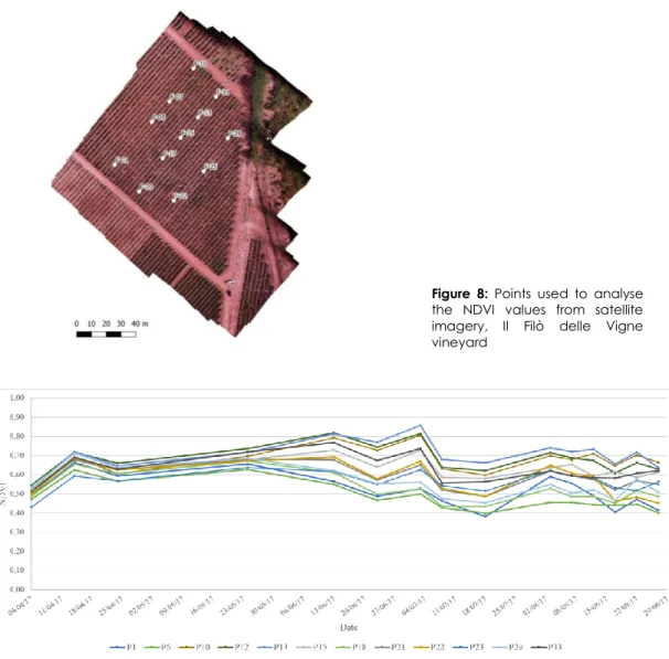
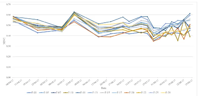
To visualize the trend of the NDVI index more easily, single pixels of the images were taken into account. Twelve points were chosen for each vineyard to characterize the heterogeneity within each site (Figures 7 and 8). Since the Maeli vineyard has a difference in altitude of 50 m, pixels were chosen to reflect this: four points were chosen in the highest area (P1, P22, P23, P21), central zone (P6, P15, P18, P29) and lower area (P10, P12, P13, P33) (Figure 7). Each point was associated with the NDVI value of the corresponding pixel for every sensing date (Figures 9 and 10).
Figure 7: Points used to analyse the NDVI values from satellite imagery, Maeli vineyard
111
Figure 8: Points used to analyse the NDVI values from satellite imagery, Il Filò delle Vigne vineyard
112 Figure 10: NDVI trend (Il Filò delle Vigne), April–August 2017
Figures 9 and10 illustrate how some points within the same vineyard present a similar trend to that of the NDVI value, but with different values in different areas. This dissimilarity between the index values is more evident in the Maeli vineyard, where points located in the lower areas have higher NDVI values than points located in the central and higher areas (Figure 9). This situation corresponds to the differences in the plants’ vigour noticed on the ground. Il Filò delle Vigne, on the other hand, appeared more homogeneous in terms of plant vigour. Here, pixels that show a trend that deviates for some dates from the other points (Figure 10) correspond to the margins of the rows (F-01, F-20, F-22, F-28, F-11).
Intercomparison of satellite and NDVI index
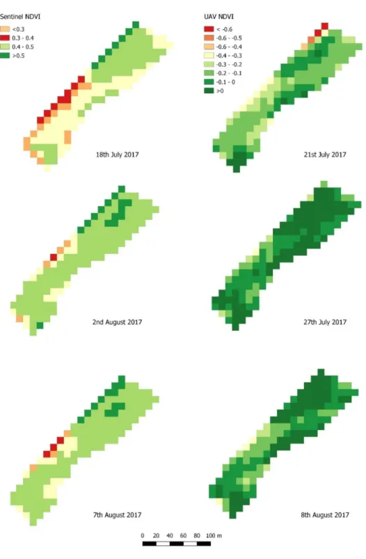
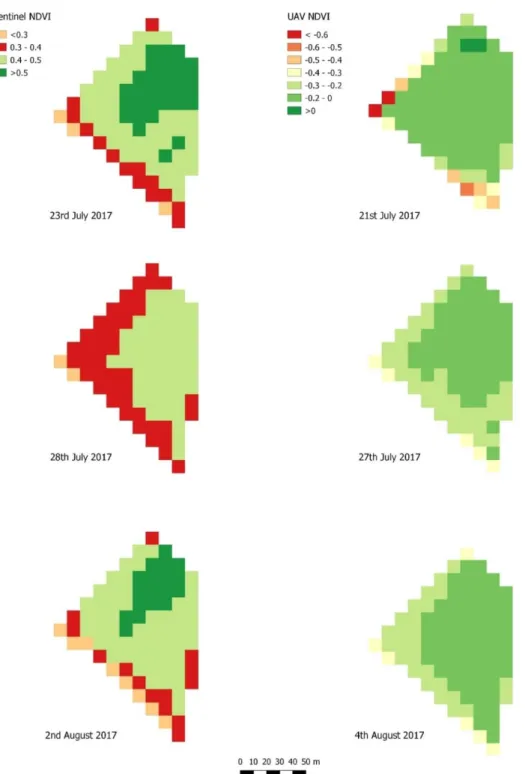
The NDVI maps derived from S2 imagery were compared with the resampled maps derived from UAV imagery, as shown in Figures 11 and 12, with a difference between the sensing dates that ranges from 1 to 5 days. As previously reported, the computation of the S2 NDVI was based on reflectance values, while the UAV index was based on DN.
The resampling of the UAV images to a coarser spatial resolution of 10 m results in the loss of information related to the different NDVI values of rows and inter-rows. The resulting pixel values are the roughly averaged NDVI value, which in most cases is a negative one. Even though the satellite and the UAV maps have different index ranges, it is possible to see some similarity in the distribution of vigour within the vineyards, especially for Il Filò delle Vigne.
113 Figure 11: Sentinel NDVI and UAV NDVI, Maeli vineyard
114
115
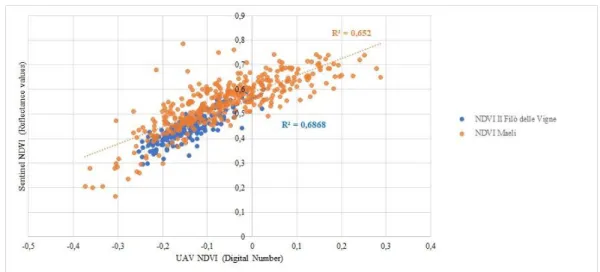
In order to compare the NDVI data from a statistical point of view, linear regression graphs were produced, which relate the satellite index values (obtained from reflectance values) with the UAV index values (obtained from DN values).
Figure 13: Linear regression graphs, Sentinel NDVI and UAV NDVI
The coefficient of determination (R2) obtained has values of 0.652 for the Maeli vineyard and
0.68 for Il Filò delle Vigne. These results reveal a certain correlation between the NDVI values obtained from the satellite and from the UAV imagery, but it must be remembered that they are computed from reflectance values in one case and DN in the other.
5
Conclusions
Preliminary results show the potential for using open source Sentinel platforms to monitor vineyards. Links can be drawn between the Sentinel-derived data and the information given in the agronomic bulletins of the Veneto Region which identify critical areas for crop production.
The analysis of the NDVI data from UAVs also showed relations with the NDVI from satellite imagery, notably similarities in the localization of areas of greater or lesser vigour of the grapevines and a certain level of correlation between the values obtained.
However, the results obtained from the analysis of the NDVI average value trend do not currently allow us to determine whether there is a concrete possibility of using Sentinel-2 data for the long-term monitoring of vineyards. The lack of data collected in the field throughout the period analysed prevents relating the NDVI trend and values with the specific situation of each vineyard. Furthermore, the lack of reflectance values for the UAV imagery does not allow us to state whether the correlation with the Sentinel data is significant.
Finally, it is important to remember that the heterogeneity of the surfaces analysed in terms of land cover (rows and inter-rows) and the spatial resolution of Sentinel imagery imply that
116
a single pixel is made up for the most part of inter-rows. Further studies are therefore needed to assess the possibility of using Sentinel-2 images in viticulture.
References
Candiago, S., Remondino, F., De Giglio, M., Dubbini, M., Gattelli, M. (2015). Evaluating Multispectral
Images and Vegetation Indices for Precision Farming Applications from UAV Images. Remote
Sensing, 7(4), pp. 4026-4047.
Matese, A., Toscano, P., Di Gennaro, S.F., Genesio, L., Vaccari, F.P., Primicerio, J., Belli, C., Zaldei, A., Bianconi, R. & Gioli, B. (2015). Intercomparison of UAV, Aircraft and Satellite Remote
Sensing Platforms for Precision Viticulture. Remote Sensing, 7, 2971-2990. doi:10.3390/rs70302971
Rouse, J.W., Haas, R.H., Schell, J.A., Deering, D.W. (1973). Monitoring vegetation systems in the
Great Plains with ERTS. In: Proceedings of the Third ERTS Symposium, NASA: Washington, DC, USA,
10–14 December 1973; NASA SP-351; pp. 309–317.
Wang, Y., Ryu, D., Park, S., Fuentes S., O’Connell, M. (2017). Upscaling UAV-borne high-resolution
vegetation index to satellite resolutions over a vineyard. 2nd International Congress on Modelling