Available online: https://edupediapublications.org/journals/index.php/IJR/ P a g e | 2965
Control and perception techniques for aerial robotics
Lanka Sunitha
1Dept.of Electronics and Communication Engineering, Malla Reddy Engineering College & Management Sciences, Kistapur, Medchal,
Hyderabad
Abstract
This paper review methods and technologies that have been applied in aerial robotics. The paper presents several unmanned aerial vehicle platforms. Then summarizes different control techniques including both control architectures and control methods. Furthermore, computer vision techniques for aerial robotics are briefly considered. Finally, the paper presents systems and projects involving multiple autonomous aerial and ground systems.
# 2004 Published by Elsevier Ltd.
Keywords: Aerial vehicles; Autonomous mobile robots; Autonomous vehicles; Helicopter control; Computer vision; Multi-robot systems
1. Introduction
In the last decades many autonomous and teleoperated vehicles for field robotics applications have been developed, including wheeled, tracked and legged vehicles. However, in many cases, ground vehicles have significant inherent limitations to access to the desired locations due to the characteristics of the terrain and the presence of obstacles that cannot be avoided. In these cases aerial vehicles is the natural way to approach the objective to get information or even to perform some actions such as the deployment of instrumentation. Then, aerial robotics seems a useful approach to perform tasks such as data and image acquisition of targets and affected areas, localization of targets, tracking, map building and others.
Unmanned aerial vehicles (UAV) have been used for military applications but also are useful for many civilian applications such as terrain and utilities inspection, disaster monitoring, environmental surveillance, search and rescue, law enforcement, aerial mapping, traffic surveillance, and cinematography. In the last years UAVs improved their autonomy both in energy and information processing. However, the development of autonomous aerial robotic
vehicles involves many problems related to limited payload, safety requirements, flight endurance and others.
This paper reviews some significant developments in aerial robotics. In Section 2 different UAV platforms are reviewed. Section 3 is devoted to UAV control emphasizing autonomous helicopter control. The environment perception techniques are considered in Section 4. Section 5 is devoted to multi-robot systems including a short presentation of the COMETS project on multiple heterogeneous aerial vehicles. The paper closes with the conclusions and the references.
2. UAV platforms
Unmanned air vehicles (UAVs) are self-propelled air vehicles that are either remotely controlled or are capable of conducting autonomous operations. UAV experimental research ranges from low-level flight control algorithm design to high level multiple aircraft coordination.
Available online: https://edupediapublications.org/journals/index.php/IJR/ P a g e | 2966
Fig. 1. The Predator from General Atomics.
Predator (see Fig. 1, with 27,000 ft altitude, 30/40 h flight and 450 lbs payload), and the Tactical UAVs such as the Pioneer with 15,000 ft altitude, 5–6 h flight and 25 kg payload. In the last years man portable or hand launched UAVs, called ‘‘Organics UAV’’, such as Pointer (Aero-Vironment), Javelin (BAI) or Black Pack Mini (Mission’s Technologies) have been presented.
Furthermore, many different Vertical Take-Off and Landing (VTOL) UAVs including helicopters and several designs such as the Guardian from Bombardier, and the Sikorksy’s Cypher or Dragon Warrior which can be operated in either wings-on (see Fig. 2) or wings-off configurations.
On the other hand, in the last years, Micro Air Vehicles, with dimensions lower than 15 cm, have gained a lot of attention. These include the Black Widow manufactured by
AeroVironment (see Fig. 3), the MicroStar from BAE and
many new designs and concepts presented in several Universities such as Entomopter (Georgia Institute of Technology), Micro Bat (California Institute of Technol-ogy), MFI (Berkeley University), as well as other designs in European Research Centres.
In the Unmanned Aerial Vehicles Roadmap (2001) a survey of platforms and UAV technologies is presented.
In many aerial robotic projects, adaptation of conven-tional remote controlled model aircrafts with modest flight endurance, altitude and payload are used. Some of these platforms are the same than used for entertainment and applications such as aerial photography, cinematography, chemical spraying, inspection and other tasks in which the
Fig. 2. The Sikorsky’s Dragon Warrior (Cypher2).
Fig. 3. Black widow (AeroVironment).
vehicles are maintained in the line of sight of the human pilot. In some cases the evolution of the conventional platforms leaded to new vehicles with increased flight endurance and payload such as the Yamaha R50 and Rmax. Thus, the Rmax is able to fly for 1 h carrying a 24-kg payload.
Aerial robotics has mainly involved helicopters and other VTOL designs, airships and fixed wing small UAVs. The main advantage of helicopters and other VTOL platforms is the manoeuvrability, which is needed for many robotic applications. The ability to maintain the aerial vehicle in hovering is very important in many tasks. However, they are difficult to control and require experienced safety pilots for their development and application. Moreover, fully auton-omous control of helicopters is a difficult task that requires the application of reliable and nonlinear control laws.
Several Universities in the USA have developed autonomous helicopters. Thus, the Robotics Institute at Carnegie Mellon University (CMU) conducted since the early nineties an autonomous helicopter project. They have developed different prototypes from small electrical radio controlled vehicles to autonomous helicopters using the Yamaha R50 platform. The autonomous CMU helicopter won the AUVSI aerial robotic competition in 1997.
The University of Southern California (USC) conducted, since 1991, an autonomous helicopter project developing several prototypes, such as the Autonomous Vehicle Aerial Tracking and Retrieval/Reconnaissance (AVATAR) proto-types presented in 1994 and 1997. The AVATAR helicopter won the AUVSI Aerial Robotics Competition in 1994.
The University of Berkeley also developed autonomous helicopters in the Berkeley AeRobot project, BEAR, in which the autonomous aerial robot is a testbed for an integrated approach to intelligent systems.
Available online: https://edupediapublications.org/journals/index.php/IJR/ P a g e | 2967
Fig. 4. Yamaha Rmax platform used in the WITAS project.
In Europe the University of Linko¨ping is conducting the WITAS project which is a long-term basic research project involving cooperation with other Universities and private companies (Doherty et al., 2000). The Yamaha Rmax helicopter is currently being used in the WITAS project (see Fig. 4). Moreover, several Universities such as the Technical University of Berlin, ETH Zurich (Eck, Chapuis, & Geering, 2001), and Universidad Polite´cnica de Madrid (Del-Cerro, Barrientos, Campoy, & Garc´ıa, 2002) are using the adaptation of conventional radio controlled helicopters with different autonomous capabilities.
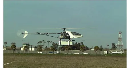
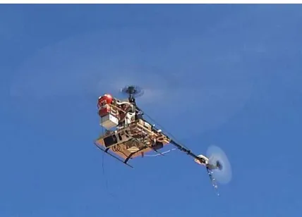
Fig. 5 shows MARVIN developed by the Technical University of Berlin (Remuss, Musial, & Hommel, 2002), which won the AUVSI Aerial Robotics Competition in 2000, and Fig. 6 the helicopter being developed jointly by the University of Seville and Helivision.
Airships (blimps) are stable platforms to take images and in case of failure present a graceful degradation which is not the case of other platforms such as helicopters. Furthermore, they can be piloted without extensive training. However, airships have significant manoeuvrability constraints, they are larger and the deployment is more difficult. Moreover, they can only fly when the wind velocity is low. Airship platforms are also used in aerial robotics projects, such as
Fig. 6. University of Seville-Helivision helicopter flying in experiments of the COMETS project (May 2003).
Karma (see Fig. 7) at LAAS (CNRS, France), Autonomous Unmanned Remote Monitoring Robotic Airship (AUR-ORA) at CENPRA (Brazil) (Bueno et al., 2002), and the airship of the University of Stuttgart (Wimmer et al., 2002).
Conventional fixed wing airplanes also have manoeuvr-ability constraints. The lack of hovering capabilities imposes significant limitations for their application in aerial robotics. However, the reach and flight endurance can be larger than helicopters and other VTOL designs. Furthermore, both manual and autonomous control are simpler. Then, many autonomous airplanes have been developed and used for reconnaissance, surveillance, environment monitoring and others. Some of these platforms are also used in aerial robotics projects involving localisation and mapping functions such as the delta wing Unmanned Aerial Vehicle Brumby at the University of Sydney, which has been designed to fly in excess of 100 knots and currently has an endurance of 1/2 to 1 h flight time. The aircraft has the capacity to carry up to 6-kg payload when remotely piloted, or 4 kg when operated autonomously.
Fig. 5. The MARVIN autonomous helicopter flying in experiments of the Fig. 7. Karma, developed at LAAS-CNRS, flying in experiments of the
COMETS project (May 2003). COMETS project (May 2003).
3. UAV control
3.1. Control architectures
On-board control architectures for UAV have to integrate a variety of sensor information (GPS, three-axis rate gyro, three-axis accelerometer, aircraft attitude reference sensor, compass, altitude sensors among others), and low level motion servo-controllers, to control the vehicle typically in different control modes. Eventually, environment percep-tion, object tracking and local reactive (obstacle avoidance) and planning capabilities are considered. However, in existing aerial robotic prototypes these capabilities are modest when comparing to
ground robots. In fact, the on-board hardware is seriously constrained by the load and energy consumption. On-board UAV control hardware is an ideal application for new embedded control systems involving FPGAs, DSPs and new
powerful microcontrollers. However, other hardware
platforms such as the PC-104 computer system with real-time Operating System are also applied to simplify the development.
Available online: https://edupediapublications.org/journals/index.php/IJR/ P a g e | 2968 The control of fixed wing aircrafts can be considered at
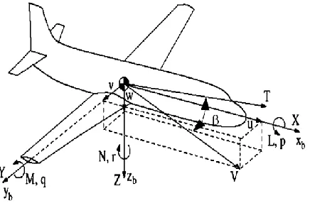
different levels (McLean, 1990). Low-level control is called stability augmentation in the airplane control domain. The objectives are perturbation rejection and improving the dynamic response when the pilot or the higher level controller/guidance system provides commands. Fig. 8 shows some of the involved variables. The linear (u, v, w) and angular velocities (p, q, r) in the airplane body axis, and orientation angles are usually considered as state variables. The control variables are the deflections of aerodynamic control surfaces (ailerons, elevator and rudder) about the three-body axis and the propulsion source (throttle). The airplane dynamics, and then the control problem, is usually decoupled in longitudinal (pitching rate q control using elevator) and lateral/directional control where the rolling
Fig. 8. Variables for UAV control.
rate (p) and the yawing rate (r) are controlled by means of the aileron and rudder.
The airplane attitude control consist of functions that allow the aircraft to be placed, and maintained, in any required orientation in space, stability augmentation being the inner control loop (McLean, 1990). The variables to be controlled are often the pitch and yaw angles, and the airplane side slip angle b. Furthermore, the objective of this control level is to perform coordinated turns without lateral acceleration and airplane sideslip. On the top of the control hierarchy is the flight path or trajectory tracking (which includes precision timing). In this case the course angle error and the cross track distance can be considered as error signals in the guidance
loop. The trajectory to be tracked can be provided by a trajectory generator which is designed to interpolate between waypoints or target points to achieve a given mission. Trajectory tracking and generation can be jointly considered by using approaches in which the dynamics of the vehicle is also used for trajectory generation and the target turning rates and heading angles obtained by the trajectory generator are used for control.
Several commercial autopilots for remotely piloted airplanes that are able to follow way points are in the market. Typically Kalman filtering techniques are applied for position estimation and the reliability and accuracy depend on the position measurement technology applied. However, the autonomous control of helicopters and other VTOL platforms with different control modes is more complex and motivated the research activities of several universities.
In the following, this section concentrates in autonomous helicopter control. The position and orientation of an helicopter (six degrees of freedom) are usually controlled by means of five control inputs: the main rotor thrust (power to the rotor), the collective input (main rotor blade angle) which has a direct effect on the helicopter height (altitude control), the tail rotor which affects the heading of the helicopter (yaw motion) and compensates the anti-torque generated by the main rotor, the longitudinal cyclic which modifies the helicopter pitch angle and the longitudinal translation, and the lateral cyclic, which affects the helicopter roll angle and the lateral translation (lateral cyclic). Then, it is a multivariable nonlinear underactuated system with strong coupling in some control loops.
The USC developed a behaviour-based architecture for the control of the AVATAR helicopter (Fagg, Lewis, Montgomery, & Bekey, 1993). The low-level behaviours correspond to the generation of the four input commands of the helicopter (collective throttle, tail rotor, longitudinal and lateral cyclic). The second level implements short-term goal behaviours: transition to altitude and lateral velocity. The highest-level behaviour, navigation control, is responsible for long-term goals such as moving to a particular position and heading.
Intelligent control architectures for unmanned air vehicles (helicopters) are also researched at Berkeley. The
hierarchical architecture segments the control tasks into different layer of abstraction in which planning, interaction with the environment and control activities are involved. The hierarchical flight management system (Kim & Shim, 2003) has a stabilization/tracking layer, a trajectory generation layer, responsible for generating a desired trajectory or a sequence of flight modes, and a switching layer which switches between several strategy planners. Both continuous and discrete event systems are considered. In order to model these control systems, hybrid system
theory has been proposed (see for example Koo, Hoffman,
Shim, Sinopoli, &Sastry, 1998).
GTI also developed autonomous helicopter control systems and research in flight controls, avionics and software systems.
3.2. Learning and pilot knowledge-based control methods
Available online: https://edupediapublications.org/journals/index.php/IJR/ P a g e | 2969 Fuzzy logic with rules generated by the observation of a
human pilot and consultation with helicopter experts is the approach used in Cavalcante and coworkers (1995).
In Montgomery, Fagg, and Bekey (1995) the behaviours of the control architecture proposed in the USC architecture are implemented as PD control loops with gains tuned by trial and error. In Montgomery and Bekey (1998), the ‘‘teaching by showing’’ approach is presented. In this work the controller is generated by using training data gathered while a human teacher controls a system until the synthesized controller can also control the system to meet predefined performance criteria.
In Buskey, Wyeth, and Roberts (2001) learning is based on the direct mapping of sensor inputs to actuator control via an artificial neural network. Then, the neural network controller was used for the helicopter hovering.
The analysis of the pilot’s execution of aggressive manoeuvres from flight test data is the base of the method presented in Gavrilets, Frazzoli, Mettler, Piedmonte, and Feron (2001) to develop a full non-linear dynamic model ofa helicopter. This model will be used in the design of new control systems for autonomous helicopters.
3.3. Model-based control methods
On the other hand, several methods have been applied for model-based control of UAVs. Modelling the UAV dynamics is a main issue. The full model of a helicopter involving the flexibility of the rotors and fuselage and the dynamics of the actuators and the combustion engine is very complex. Then, in most cases, the helicopter is considered as a rigid body with inputs forces and torques applied to the
centre of mass and outputs the position and linear velocities of the centre of mass, as well as the rotation angles and angular velocities. Furthermore, the relations between the control inputs of the helicopter and the above mentioned forces and torques should be considered in the model. In general, these relations involve the consideration of the aerodynamics of the fuselage and the effect of stabilizers. However, at low speeds these effects can be ignored (Koo &Sastry, 1998).
In Kim and Tilbury (2004) a mathematical model and experimental identification of a model helicopter is presented. The model of the interactions between the stabilizer flybar and the main rotor blade is also included showing its effects in the stability of the model helicopter. The identification of the parameters is performed on a SISO basis using a specially built stands to restrict the motion of the helicopter to one degree of freedom. It should be noted that the identification from input–output data, collected when a human pilot is controlling the vehicle, is difficult because it is not possible to study the individual effect of each control input (the pilot has to apply more than one input to maintain the stability).
In Mettler, Tischler, and Kanade (2002) a parametrized model of the Yamaha R-50 autonomous helicopter is identified using frequency domain methods. The stabilizer bar
is also taken into account. The model is verified with special flight experiments using doublet-like control inputs in hover and forward flight showing its ability to predict the time domain response of the helicopter to control inputs.
It has been shown that the multivariable nonlinear helicopter model cannot be converted into a controllable linear system via exact state space linearization. In addition, for certain output functions, exact input–output linearization results in unstable zero dynamics. However, if only the position and heading are chosen as outputs, by neglecting the coupling between moment and forces, the approximated system with dynamic decoupling is full state linearizable and output tracking can be applied (Koo & Sastry, 1998).
It should be noted that in hovering, the nonlinear system can be linearized and then multivariable linear control
techniques such as LQR and H1 can be applied. In Kim and Shim (2003) multi-loop linear PID techniques also obtained good results when applied to the Yamaha R-50. However, if large perturbations should be compensated, or significant tracking abilities are required, this strategy could not be enough. In this case further improvements can be obtained by adding nonlinear control terms that compensate significant deviations with respect to the hovering condi-tions.
In Kadmiry, Bergsten, and Driankov (2001) a fuzzy gain-scheduling approach, based on the linearization of the original nonlinear helicopter model, is proposed and tested in simulation.
Johnson and Kannan (2002) combine the helicopter attitude inner control loop and the outer trajectory control loop and apply adaptive techniques to cancel model errors by preventing unwanted adaptation to actuator limits and dynamics in the inner loop.
In Shim, Koo, Hoffman, and Sastry (1998) linear robust multivariable control, fuzzy logic control and nonlinear tracking control are compared in the simulation of two scenarios: vertical climb and simultaneous longitudinal and lateral motion. It is noted that nonlinear control techniques by applying feedback linearization are more general and cover wider ranges of flight envelopes but requires accurate knowledge about the system and are sensitive to model disparities, such as changes in the payload, or to the aerodynamic thrust–torque model.
In general no guarantee of robustness against model uncertainties or disturbances and no adaptive capabilities are provided by many feedback linearization techniques. However, in some cases, nonlinear controller robustness properties are increased using sliding mode and Lyapunov-based control (Maharaj, 1994). Typically, these techniques trade the controller performance against uncertainty, but require a priori estimates of parameter bounds, which may be difficult to obtain.
Available online: https://edupediapublications.org/journals/index.php/IJR/ P a g e | 2970 synchronization of the vertical motion of the helicopter
with a sea carrier subject to wave-induced oscillations, and then the reference signals are sum of sinusoidal signals (assumed not to be available to the controller). A nonlinear adaptive output regulation and robust stabilization of systems in feed-forward form by means of saturated control is applied in simulation. The simulation results show robustness against uncertainties on the model and on the exogenous reference signal. The method also requires the a priori computation of robustness bounds.
In Kim and Shim (2003), the application of nonlinear model predictive control is proposed. At each sample time, the controller computes a finite control sequence which minimizes a quadratic index. This index includes the errors of the outputs (helicopter coordinates and heading) with respect to desired trajectories, additional state variables which should be bounded, and the control actions (long-itudinal and lateral cyclic pitch, collective, and tail rotor). A gradient descent technique is used to compute the optimal values of the control variable. The method improves the tracking performance at the expenses of heavy computing load.
In Fantoni and Lozano (2002) the control of under-actuated systems including helicopters and Planar VTOL (PVTOL) is studied. Several control techniques are presented including backstepping, energy-based controllers and Lypunov-based controllers.
At CMU a high-order linear model of the R-50 Yamaha helicopter is used for control. This model was extracted by
using the Modelling for Flight Simulation and Control Analysis (MOSCA) with a nonlinear simulation model of the helicopter. The controller consists of one multivariable (MIMO) inner loop for stabilization and four separate (SISO) guidance loops for velocity and position control. Several manoeuvre tests have been conducted with the helicopter (square, forward turn, backward turn and nose-out circle). The controller is designed for hovering but its robustness leads the helicopter to perform the manoeuvres efficiently even if the trajectories are not optimal (La Civita,Papageorgiou, Messner, & Kanade, 2003).
4. Environment perception techniques
Environment perception technologies used within UAVs includes cameras and range sensors. For some particular operations such as autonomous landing, range sensors (laser and ultrasonics) are widely used. However, computer vision plays the most important role. Computer vision is used for several applications, from autonomous UAV control to detection, monitoring or terrain mapping.
4.1. Vision-based position estimation
Vision is used as a positioning sensor in several UAV projects. It is argued that some applications that need a very accurate relative position of the UAV respect to objects, as close proximity flight, can not rely on inertial navigation systems or global positioning systems (Amidi, 1996). Thus, vision is used as a method to sense relative position.
The concept of visual odometer (Amidi, Kanade, &Fujita, 1998)was implemented in the CMU autonomoushelicopter. Using this concept the helicopter can visually lock-on to ground objects and sense relative helicopter position and velocity in real time. Template matching techniques are used to estimate the displacement of the object between consecutive images. This, combined with angular rate sensing, allows to estimate the UAV motion. In this case only a few templates are tracked. Each cycle new targets are selected to avoid losing targets. The same visual tracking techniques, combined with inertial sensors, have been applied to autonomously take off, follow a prescribed trajectory, and landing. The CMU autonomous helicopter also demonstrated autonomous tracking capabilities of moving objects by using only on-board hardware.
The use of vision for autonomous landing has been actively researched. In the early nineties, Dickmanns and Schell (1992) presentedsome results of the possible use of vision for landing an airplane. Zhang and Hintz (1995) developed a video-based attitude and height sensor for low altitude airborne vehicles. Neural networks are used to compute attitude and height from the measures obtained by a video camera that observes the structured light pattern created by a set of infrared lasers. Yakimenko, Kaminer, Lentz, and Ghyzel (2002) considerthe problem of
determining the position and orientation of an aircraft with respect to a ship from the images of several points taken by an infrared camera.
In the BEAR project, vision-based pose-estimation of unmanned helicopters relative to a landing target and vision-based landing of an aerial vehicle on a moving deck are researched (Shakernia, Vidal, Sharp, Ma, & Sastry, 2002; Vidal, Sastry, Kim, Shakernia, & Shim, 2002). In thisproject, results on multiple view geometry are used to impose constraints over multiple views of a planar landing target with a single camera. These constraints, summarized in the so called multiple view matrix, allows to compute the displacement of the UAV given three or more views of the target. The known size of the landing target allows to obtain
the scale of the displacement. Using off-the-shelf hardware, the vision system in the BEAR project is able to operate at 30Hz. The feature extraction and matching are simplified by using an artificial target of known shape. Vision is situated in the control loop as a high lever supervisor which sends the current position of the landing target to the navigation controller.
Available online: https://edupediapublications.org/journals/index.php/IJR/ P a g e | 2971 moments of inertia of the known helipad) and a Kalman
filter for target tracking.
Saripally and Sukhatme (2003) alsopresent a technique for helicopter position estimation using a single CMOS pointing downward camera with a large field of view and a laser pointer to project a signature onto the surface below in such a way that can be easily distinguished from other features on the ground.
Most of previous techniques rely on feature matching techniques. Recent focus has been put on algorithms for extraction of robust and invariant features for wide-baseline matching. Thus, in the WITAS UAV project, a method for robust extraction of affinely invariant features has been developed (Forsee´n & Granlund, 2003).
4.2. Simultaneous localization and mapping (SLAM) with UAVs using vision
SLAM techniques are closely related to the position estimation problems. SLAM is now a well known technique and has been used mainly with ground robots. Among them, only a few are based mainly on vision sensors. Also, there are some applications of vision for SLAM with UAVs.
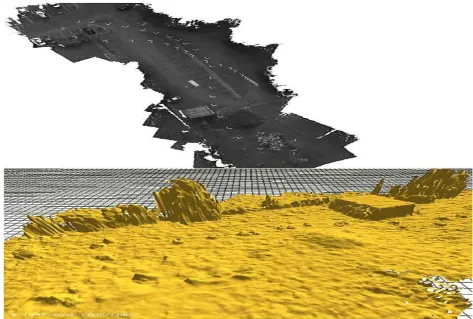
Terrain mapping techniques have been developed at the LAAS (Lacroix, Jung, & Mallet, 2001). The perception system being designed for the Karma airship (Lacroix et al.,
2001, Lacroix, Jung, Soueres, Hygounenc, & Berry, 2002) applies stereo vision, interest point matching and Kalman filtering techniques for simultaneous localization and mapping using only vision. The robust interest point matching algorithm combined with stereo vision is used for blimp position estimation. Some of the interest points are used as landmarks in the SLAM approach for the filter update phase. By using stereo vision a dense range map can be obtained. Karma carries a stereo bench 2 m wide (place along the blimp gondola), and is able to build maps with an accuracy of 10 cm height and a cell resolution of 5 cm2. Fig. 9 shows an example of a map generated by the
blimpKarma.
UAV simultaneous localisation and map building with vision using a delta fixed wind platform is also presented in Kim and Sukkarieh (2003).Artificial landmarks of knownsize are used in order to simplify the landmark identification problem. The known size of the landmarks allows to use the cameras as a passive range/bearing/elevation sensor. In this work images of known landmarks and inertial data are used as ground truth and they show the corrective properties of the SLAM algorithm.
Available online: https://edupediapublications.org/journals/index.php/IJR/ P a g e | 2972 Also, scanner laser sensors have been used in the CMU
helicopters to build terrain maps. This helicopter built accurate aerial maps of the experimental site of the VSAM project and portions of the Haughton crater in Devon Island for NASA geologists.
4.3. Monitoring and other applications
The mobility of UAVs providing the possibility of changing at will, the point of view make them very suitable vehicles for monitoring applications.
Detecting moving objects on the image plane is an important function for monitoring applications. Thus, novel and fast algorithms for dense motion estimation have been developed within the WITAS project. In Farneba¨ck and Nordberg (2002),a two frame motion estimation algorithm based on a multi-scale polynomial expansion of the images allows to obtain a dense motion field, used for ground vehicle detection in traffic monitoring applications. Other computer vision activities in the WITAS project are described in Nordberg, Doherty et al. (2002).
In the BEAR project, vision is also used to detect evaders and determine their position in pursuit-evasion games (Vidal et al., 2002). The evaders are detected looking for objectsthat move independently on the image plane. The number of independent moving objects is obtained analyzing the optical flow matrix for multiple points across several frames.
Motion estimation, object identification and geolocation by means of computer vision are also researched in the framework of the COMETS project (Merino & Ollero, 2002a, 2002b). In this project fire monitoring using UAVs is considered as an application scenario. The perception system designed in this project also implements image stabilization by using visual tracking techniques. Further-more, the above mentioned terrain mapping techniques with the Karma airship are also being integrated in the COMETS system and will be used to provide terrain maps required for geolocation and other applications.
Fig. 10 shows the result of using aerial images for fire monitoring. Threshold-based techniques are used for fire segmentation. The fire front is identified and then geolocated. Image stabilization is used to track correctly the position of the fire front. Fig. 10 (bottom panel) shows the evolution of the fire front each 40 s for an experiment of controlled forest fires carried out in Portugal (May 2002).
Other applications of computer vision are the detection of targets and the interpretation of scenes from the aerial images. Thus, for example, the MARVIN helicopter at TUB and the CMU helicopter have used vision during the AUVSI Unmmanned Aerial Robotic Competition to achieve the goals of the competition.
MARVIN (Remuss, Musial & Hommel, 2002) uses a still digital camera. This camera is able to take high-quality images of large resolution at low frame rates (640 480 at 0.2 Hz or 1024 768 at 0.08 Hz). Combined with an
Fig. 10. Experiments of fire monitoring using aerial images. Top panel: one
of the images taken. Bottom panel: estimated fire front evolution.
adequate searching strategy, they succeeded looking for casualties in the scenario of the competition.
CMU helicopter uses principal component analysis to store templates of interesting objects, and to detect them posteriorly. This has been used successfully for the detection of hazard labels on barrels during the AUVSI competition.
Object identification of ground targets by using previously known appearance or colour has been also implemented by several authors. In Merino et al. (2003), the identification of other aerial vehicles from on-board cameras by using a phase-only matched filter is presented. Bueno etal. (2002) present results on-road identification and tracking using vision in the AURORA airship. They use spectral characteristics of the targets for identification purposes.
Image processing techniques have been proposed for cable segmentation and tracking for inspection of power lines (Del-Cerro et al., 2002). Stereo vision is also proposed to maintain the UAV at a desired distance from the inspected cables.
4.4. Other perception sensors
Available online: https://edupediapublications.org/journals/index.php/IJR/ P a g e | 2973 control in Das et al., 2002). Initial approaches for its use in
UAVs are being presented. Thus, in Hrabar and Sukhatme
(2003) an experiment to study the feasibility of using omnidirectional cameras within a VTOL UAV is presented. In the tests, they use the omnidirectional camera to detect a set of targets and to generate control commands to situate the UAV at the centroid of these targets.
In Netter and Franceschini (2002), an artificial camera eye, consisting of a one dimensional 20-pixel linear photoreceptor and analog electronic processing circuits are used for terrain following and obstacle avoidance in a test-bed for MAVs.
4.5. Implementation issues
An important aspect on the application of computer vision techniques in aerial robots is the computational power needed. Also, the application of computer vision techniques on ground computers is seriously constrained by the communication bandwidth and then it cannot be considered for certain applications, such as motion control.
The CMU helicopter uses custom vision hardware to perform on-board all the computer vision and control activities. On-board computer vision is needed for helicopter control (visual odometer) and for efficient robotic tracking of moving objects. Using dedicated hardware, it can operate at 60 Hz, 1/30 s of latency. The system is included into the control loop, and it is used to stabilise and maneuver small helicopters over reasonable speeds (15 mph).
The BEAR project uses off-the-shelf hardware for vision-related processing, consisting on a Little Board PC running Linux, separated from the navigation computer. They can process images at 30 Hz.
A flexible runtime system for image processing has been developed and implemented inside the WITAS UAV platform (Nordberg, Forsee´n, Wiklund, & Andersson, 2002). The image processing module communicates with the rest of the system using CORBA. Also, important efforts have been devoted in the WITAS project in order to design custom and highly efficient vision algorithms for filtering and feature extraction.
5. Multi-robot systems
Over past few years research on the coordination and cooperation of multiple UAVs and of multiple aerial and ground autonomous systems has been conducted.
Several efforts are related to the coordination of homogeneous teams of aeroplanes (McLain, 2000). The problems are related to the control of multiple UAVs (aeroplanes) in close-formation flight, as for example in the Air Force Research Laboratory (Schumacher & Singh, 2000);or in the Air Force Institute of Technology (Hall & Pachter, 1999). The Phoenix Project at Princeton Universityalso considers the coordinated flight of a fleet of
homogeneous UAVs (aeroplanes) and the design scenario is autonomous aerobatic manoeuvring. The problem of autonomous formation flight control is also considered in Giulietti, Pollini, and Innocenti (2000) where a standard linear quadratic control structure is synthesized for each vehicle and for the formation. The definition of a formation management structure capable of dealing with a variety of transmission and communications failures between aircraft is also presented.
Formation flights have been proposed as a way to deploy multiple sensors on the terrain. This strategy can be considered as biologically inspired (animals that have the ability to form formations such as flocks of birds).
Multiple flying helicopters and groups of helicopters and ground vehicles are considered in the BEAR project. The research includes hierarchical multiagents system architec-tures for coordinated team efforts, vision-based pose-estimation of multiple UAVs and ground vehicles, and pursuit-evasion games in which a team of UAVs and ground vehicles pursue a second team of evaders while concurrently building a map in an unknown environment (Vidal et al.,2002).
The cooperation between aerial and ground robots is also researched at USC. In Sukhatme, Montgomery, and Vaughan (2001) different cooperation cases are studied such as the use of an aerial robot in a marsupial-style deployment of a small wheeled robot and the localisation of an aerial robot by visually locating and communicating with a ground robot. ‘‘Micro’’ air vehicles (MAV) are also researched (Vaughan, Sukhatme, Mesa-Martinez, & Mon-tgomery, 2000)in this framework. Furthermore, the Raptor project (Saripally, Naffin, & Sukhatme, 2002) considers the use of small electric-powered radio-controlled model helicopters (electric powered) with micro-controllers and Micro Electro-Mechanical based Sensors (MEMS). Relative localization of each robot will be accomplished using only local sensing (CMOS camera), in contrast to global localization techniques (GPS), and then it could be applied in environments where GPS is not available (i.e. indoors or between skyscrapers). Each robot will only have knowledge of its relative location with respect to one or more of its neighbours.
The main objective of the COMETS project (Merino &
Ollero, 2002) is to design and implement a distributed control system for cooperative detection and monitoring using heterogeneous unmanned aerial vehicles (UAVs). Particularly, both helicopters and airships are considered.
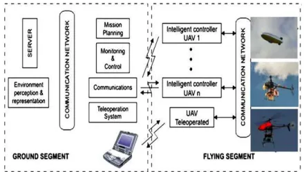
In order to achieve this general objective, a control architecture has been designed, new control techniques are being developed, and the integration of distributed sensing techniques and real-time image processing capabilities is considered. Fig. 11 shows a general picture of the COMETS system.
Available online: https://edupediapublications.org/journals/index.php/IJR/ P a g e | 2974
Fig. 11. The COMETS system.
vehicles due to the requirements on the required coverage and the different characteristics of the vehicles. Further-more, this approach leads to redundant solutions offering greater fault tolerance and flexibility when comparing with the use of a single UAV with long endurance flight and important on-board capabilities. The project also involves the cooperation between robotic aerial vehicles and remotely piloted vehicles. This approach will take benefit from the expertise of human operators in missions where the full autonomy is very difficult to achieve, but pose additional coordination and control problems due to the variability of the human operator.
In order to test and validate these concepts and systems, experiments and demonstrations are being carried out in forest fire alarm confirmation, localisation and monitoring. The first experiments with two helicopters and one airship have been carried out in May 2003.
5.1. Multi-robot perception
Cooperative perception is a key issue in the COMETS project. Several heterogeneous UAVs will be used for mapping, detection and monitoring applications. The UAVs are equipped with sensors of different modalities, such as infrared and visual cameras. The redundancies in the system will be used to reduce false alarms in fire detection activities and for precise localisation of interesting objects. In fire monitoring applications the UAVs will collaborate in order to situate themselves in the best positions to obtain the important characteristics of the fire, avoid smoke, etc.
In Ling, Ridley, Kim, Nettleton, and Sukkarieh (2003) an architecture for multi-vehicle SLAM is studied for its use with UAVs. The issues of data association and commu-nication are dealt with, and some simulation results are presented. In the approach, the map information (repre-sented as the location of a discrete set of landmarks) estimated for each vehicle is propagated to the rest of the fleet. The distributed information is based on the information form of the Kalman filter. Each vehicle uses the information received to update its state and its local map. The fact that the landmarks do not move allows the estimation of other vehicles to be received at arbitrary latency and order.
6. Conclusions
In the last 10 years a significant progress toward autonomous aerial vehicles with on-board intelligent capabilities has been experienced. This progress is fuelling the development of Aerial Robots with significant auton-omous capabilities. These systems open new applications in Field Robotics including surveillance, disaster (environ-mental, industrial and urban) remediation, search and rescue, environment monitoring and many others.
Many different techniques have been applied for UAV control and particularly for autonomous helicopter control. These include techniques to cope with the expertise of human pilots by means of predefined rules or by autonomous learning from the pilots, and model-based control methods. Both linear and nonlinear control techniques have been applied for model-based control. Some of these methods are shortly reviewed in the paper.
Computer vision is the most relevant perception technology applied in aerial robotics perception. It is applied for motion and position estimation, object detection and tracking, autonomous take-off and landing, as well as for applications such as detection, monitoring and terrain mapping.
Finally, the paper has presented a summary of the recent research on multiple aerial robots and coordination of aerial and ground robots, and has shortly presented the COMETS project on the real-time coordination and control of multiple unmanned aerial vehicles.
Acknowledgements
This work has been carried out in the framework of the COMETS project (European Commission, IST 2001-34304) and the CROMAT project (Spanish National Research Programme DPI2002-04401-C03-03).
The partners of COMETS are AICIA-Universidad de Sevilla (Scientific and Technical Coordinator, Spain), GMV (Administrative and Financial Coordinator, Spain), LAAS-CNRS (France), Technical University of Berlin (Germany), ADAI-University of Coimbra (Portugal), University of Linko¨ping (Sweden) and Helivision (Spain). The authors acknowledge the partners for collaborative work mentioned in the paper. Furthermore, the information and comments provided by the partners of the COMETS team at AICIA— University of Seville is acknowledged.
References
Amidi, O., Kanade, T., Fujita, K. (1998). A visual odometer for autonomous helicopter flight. Proceedings of IAS-5.
Amidi, O. (1996). An Autonomous Vision-Guided Helicopter. Ph.D. Dis-sertation.
Available online: https://edupediapublications.org/journals/index.php/IJR/ P a g e | 2975
2002 IEEE/RSJ International Conference on Intelligent Robots and Systems—IROS 2002. Proceedings of the Workshop WS6 Aerial Robotics (pp. 43–54).
Buskey, G., Wyeth, G., & Roberts, J. (2001). Autonomous helicopter hover using an artificial neural network. In Proceedings of the 2001 IEEE International Conference on Robotics & Automation (pp. 1635– 1640).
Cavalcante, C., Cardoso, J., Ramos, J. G., & Nerves, O. R. (1995). Design and tuning of a helicopter fuzzy controller. In Proceedings of 1995 IEEE International Conference on Fuzzy Systems Vol. 3 (pp. 1549–1554).
Das, A. K., Fierro, R., Kumar, V., Ostrowski, J. P., Spletzer, J., & Taylor, C. J. (2002 May). A vision-based formation control framework. IEEE Transactions on Robotics and Automation 24(5).
Dickmanns, E. D., & Schell, F. R. (1992 December). Autonomous landing of airplanes using dynamic machine vision. In Proceedings of the IEEE Workshop Applications of Computer Vision (pp. 172–179). Del-Cerro, J., Barrientos, A., Campoy, P., & Garc´ıa, P. (2002). An
auton-omous helicopter guided by computer vision for inspection of overhead power cable. 2002 IEEE/RSJ International Conference on Intelligent Robots and Systems—IROS 2002. Proceedings of the Workshop WS6 Aerial Robotics (pp. 69–78).
Doherty, P., Granlund, G., Kuchcinski, K., Sandewall, E., Nordberg, K., Skarman, E. et al. (2000). The WITAS Unmanned Aerial Vehicle Project. In Proceedings of the 14th European Conference on Artificial Intelligence—ECAI 2000 (pp. 747–755).
Eck, C., Chapuis, J., & Geering, H. P. (2001). Inexpensive autopilots for small unmanned helicopters. In Proceedings of the Micro and Mini Aerial Vehicles Conference, MAV2001.
Fagg, A. H., Lewis, M. A., Montgomery, J. F., & Bekey, G. A. (1993). The USC Autonomous Flying vehicle: An experiment in real-time beha-viour-based control. In Proceedings of the 1993 IEEE/RSJ International Conference on Intelligent Robots and Systems, IEEE (pp. 1173–1180).
Fantoni, I., & Lozano, R. (2002). Nonlinear control of underactuated mechanical systems. Springer.
Farneba¨ck, G., & Nordberg, K. (2002 March). Motion detection in the WITAS project. In Proceedings of SSAB 02 Symposium on Image Analysis (pp. 99–102).
Forsee´n, P.-E., & Granlund, G. (2003 June–July). Robust multi-scale extraction of Blob Features. In Proceedings of the 13th Scandinavian Conference on Image Analysis (pp. 11–18).
Garcia-Pardo, P. J., Sukhatme, G. S., & Montgomery, J. F. (2001). Towards vision-based safe landing for an autonomous helicopter. Robotics and Autonomous Systems, 38(1), 19–29.
Gavrilets, V., Frazzoli, E., Mettler, B., Piedmonte, M., & Feron, E. (2001). Aggressive maneuvering of small autonomous helicopters: A human-centered approach. The International Journal of Robotics Research, 20(10), 795–807.
Giulietti F., Pollini L., & Innocenti, M. (2000, December). Autonomous formation flight. IEEE Control System Magazine, 34–44.
Hall J. K., & Pachter M. (1999). Formation Maneuvers in Three Dimensions (Report of the Air Force Institute of Technology). Hrabar, S., & Sukhatme, G. S. (2003 September). Omnidirectional vision
for an autonomous helicopter. In Proceedings of the IEEE International Conference on Robotics and Automation, 2003. ICRA’03 (pp. 558– 563).
Isidori, A., Marconi, L., & Serrani, A. (2001). Robust nonlinear motion control of a helicopter. In Proceedings of the 40th IEEE Conference on Decision and Control (pp. 4586–4591).
Johnson, E. N., & Kannan, S. K. (2002 August). Adaptive flight control for an autonomous unmanned helicopter. AIAA Guidance, Navigation and Control Conference, Number AIAA-2002-4439.
Kadmiry, B., Bergsten, P., & Driankov, D. (2001). Autonomous helicopter using fuzzy-gain scheduling. In Proceedings of the IEEE International Conference on Robotic & Automation ICRA (pp. 2980–2985). Kim, H. J., & Shim, D. H. (2003). A flight control system for aerial
robots: Algorithms and experiments. Control Engineering Practice, 11, 1389– 1400.
Kim, J.-H., & Sukkarieh, S. (2003). Airborne simultaneous localization and map building. In Proceedings of the IEEE International Conference on Robotics and Automation, 2003 Vol. 1 (pp. 406–411). Kim, S. K., & Tilbury, D. M. (2004). Mathematical modelling and
experi-mental identification of an unmanned helicopter with flybar dynamics. Journal of Robotics Systems, 21(3), 95–116.
Koo, T. J., Hoffman, F., Shim, H., Sinopoli, B., & Sastry, S. (1998). Hybrid control of model helicopters. In Proceedings of the IFAC Workshop on Motion Control (pp. 285–290).
Koo, T. J., & Sastry, S. (1998). Output tracking control design of a helicopter model based on approximate linearization. In Proceedings of the 37th IEEE Conference on Decision and Control (pp. 3635–3640).
La Civita, M., Papageorgiou, G., Messner, W. C., & Kanade, T. (2003). Design and flight testing of a gain-scheduled H-infinity loop shaping controller for wide-envelope flight of a robotic helicopter. In Proceed-ings of the 2003 American Control Conference (pp. 4195–4200). Lacroix, S., Jung, I.-K., & Mallet, A. (2001). Digital elevation map
building from low altitude stereo imagery. In Proceedings of the 9th International Symposium on Intelligent Robotic Systems—SIRS’01 (pp. 207–216).
Lacroix, S., Jung, I.-K., Soueres, P., Hygounenc, E., & Berry, J.-P. (2002). The autonomous blimp project of LAAS/CNRS—Current status and research challenges. 2002 IEEE/RSJ International Conference on Intel-ligent Robots and Systems—IROS 2002. Proceedings of the Workshop WS6 Aerial Robotics (pp. 35–42).
Ling, L., Ridley, M., Kim, J.-H., Nettleton, E., & Sukkarieh, S. (2003 December). Six DoF decentralised SLAM. In Proceedings of 2003 Australasian Conference on Robotics and Automation.
Maharaj, D.Y. (1994). The application of non-linear control theory to robust helicopter flight control. PhD Thesis. Dept of Aeronautics, Imperial College of Science, Technology and Medicine, 1994. McLain, T. W. (2000). Coordinated Control of Unmanned Air Vehicles.
In Proceedings of the 2000 American Control Conference, and Visiting Scientist Summer 1999 Final Report.
McLean D. (1990). Automatic flight control systems. Englewood Cliffs, NJ:
Prentice-Hall.
Merino, L., & Ollero, A. (2002). Forest fire perception using aerial images in the COMETS Project. 2002 IEEE/RSJ International Conference on Intelligent Robots and Systems—IROS 2002. Proceedings of the Work-shop WS6 Aerial Robotics (pp. 11–22).
Merino, L., & Ollero, A. (2002). Computer vision techniques for fire monitoring using aerial images. In Proceedings of the IEEE Conference on Industrial Electronics, Control and Instrumentation IECON 02 Seville.
Merino, L., Ollero, A., Ferruz, J., Martinez de Dios, J. R., & Arrue, B. C. (2003 June–July). Motion analysis and geo-location for aerial monitor-ing in the COMETS multi-UAV System. In Proceedmonitor-ings of the IEEE 11th International Conference on Advance Robotics.
Mettler, B. F., Tischler, M. B., & Kanade, T. (2002). System Identification modelling of a small-scale rotorcraft for flight control design. Interna-tional Journal of Robotics Research, 20(10), 795–807.
Montgomery, J. F., Fagg, A. H., & Bekey, G. A. (1995). The USC AFV-I: A behaviour based entry. 1994 Aerial Robotics Competition (pp. 16– 22) IEEE Expert.
Montgomery, J. F., & Bekey, G. A. (1998). Learning helicopter control through ‘‘teaching by showing’’. In Proceedings of the 37th IEEE Conference on Decision and Control.
Netter, T., & Franceschini, N. (2002 October). A robotic aircraft that follows terrain using a neuromorphic eye. In Proceedings of 2002 IEEE/RSJ International Conference on Intelligent Robots and Systems—IROS 2002 (pp. 129–134).
Available online: https://edupediapublications.org/journals/index.php/IJR/ P a g e | 2976
tional environment for an unmanned aerial vehicle. In Proceedings of IWSSIP 2002.
Remuss, V., Musial, M., & Hommel, G. (2002). MARVIN—An autono-mous flying robot-bases on mass market. 2002 IEEE/RSJ International Conference on Intelligent Robots and Systems—IROS 2002. Proceed-ings of the Workshop WS6 Aerial Robotics (pp. 23–28).
Saripally, S., Naffin, D., & Sukhatme, G. S. (2002). Autonomous flying vehicle research at the University of Southern California. In Proceeding of the First International Workshop on Multi-Robot Systems.
Saripally, S., & Sukhatme, G. S. (2003). Landing on a mobile target using an autonomous helicopter. IEEE Conference on Robotics and Automation, 2003.
Schumacher, C., & Singh, S. N. (2000). Nonlinear control of multiple UAVs in close-coupled formation flight. 2000 AIAA Guidance, Navigation, and Control Conference.
Shakernia, O., Vidal, R., Sharp, C., Ma, Y., & Sastry, S. (2002). Multiple view motion estimation and control for landing and unmanned aerial vehicle. In Proceedings of the IEEE International Conference on Robotics and Automation.
Shim, H., Koo, T. J., Hoffman, F., & Sastry, S. (1998). A comprehensive study of control design of an autonomous helicopter. In Proceedings of the 37th IEEE Conference on Decision and Control (pp. 3653–3658).
Sugeno, M., Griffin, M. F., & Bastian, A. (1993). Fuzzy hierarchical control of an unmanned helicopter. In Proceedings of the 17th IFSA World Congress (pp. 179–182).
Sukhatme, G. S., Montgomery, J., & Vaughan, R. T. (2001). Experiments with aerial-ground robots. In T. Balch & L. E. Parker (Eds.), Robot teams: From diversity to polymorphism. AK Peters.
Unmanned Aerial Vehicles Roadmap. (2001). Washington: Office of the Secretary of Defense.
Vaughan, R. T., Sukhatme, G. S., Mesa-Martinez, J., & Montgomery, J. A. (2000). Fly spy: Lightweight localization and target tracking for coop-erating air and ground robots. In Proceedings of the 5th International Symposium on Distributed Autonomous Robotic Systems (pp. 315–324).
Vidal, R., Sastry, S., Kim, J., Shakernia, O., & Shim, D. (2002). The Berkeley Aerial Robot Project (BEAR). 2002 IEEE/RSJ International Conference on Intelligent Robots and Systems—IROS 2002. Proceed-ings of the Workshop WS6 Aerial Robotics (pp. 1–10).
Wimmer, D.-A., Bildstein, M., Well, K. H., Schlenker, M., Kungl, P., & Kro¨plin, B.-H. (2002). Research airship ‘‘Lotte’’. Development and operation of controllers for autonomous flight phases. 2002 IEEE/RSJ International Conference on Intelligent Robots and Systems—IROS 2002. Proceedings of the Workshop WS6 Aerial Robotics (pp. 55–68). Yakimenko, O. A., Kaminer, I. I., Lentz, W. J., & Ghyzel, P. A. (2002 October). Unmanned aircraft navigation for shipboard landing using infrared vision. IEEE Transactions on Aerospace and Electronic Sys-tems, 38(4), 1181–1200.
Zhang, Z., & Hintz, K. J. (1995). Evolving neural networks for video attitude and hight sensor. In Proceedings of the 1995 SPIE International Symposium on Aerospace/Defense Sensing and Control (pp. 383–393).
Anı´bal Ollero. Electrical Engineering (1976), Dr Engineer (1980) with honors (doctorate award 1978–1980), University of Seville. He has been assistant Prof. at the University of Sevilla, full Prof. and Head of Department at the University of Santiago (Vigo, Spain) and University of Ma´laga (Spain), Director of the School of Engineering. Stagiere at LAAS-CNRS, Toulouse, France (1979) and visiting scientist (1990–1991) at the Robotics Institute, Carnegie Mellon University, Pittsburgh, PA, USA.Since 1993 he is full Prof. at the E.S Ingenieros, University of Seville. He has 27 years of R&D activities in autonomous systems including robotics, computer vision and intelligent control systems. He participated or leaded in 56 research and development projects, including 10 projects funded by the European Commission and other projects funded by NASA, the Spanish National Research Program, the Regional Research Program and several institutions and companies. He is currently the Scientific and Technical Coordinator of the European IST Project: ‘‘Real-time coordination and control of multiple heterogeneous unmanned aerial vehicles’’ (COMETS), and participates in two European Projects and in one network. Furthermore he is the Coordi-nator of the Spanish Project ‘‘Coordination of Aerial and Ground Mobile Robots’’.Prof. Ollero is the author of two books, being one of them ‘‘Premio Mundo Electro´nico’’ (spanish award), and author or co-author of more than 250 publications including papers in journals, book chapters and conference proceedings. He is Associate Editor of several journals including Control Engineering Practice and IEEE Transactions on Systems Man and Cyber-netics. He is the Chairman of the Co-ordinating Committee on ‘‘Mecha-tronics, Robotics and Components’’, of the ‘‘International Federation of Automatic Control (IFAC)’’ where he has also been Chairman of the Instrumentation and Manufacturing Coordinating Committee (1999– 2002) and Chairman of the Components and Instruments Committee (1993–1999). He has been member of several R&D Expert Committees of the Spanish Government and Regional Government, and project reviewer for the Spanish National Evaluation Agency, and the European Commission