DISCUSSION
This section is intended to prol'ide a forum for the discussion of paper.s published in the Journal by those working in similar fields of investigation and re3earch. Such a discussion is expected to be of value not only to the actual workers in the concerned field, but also to a wider circle of readers interested in the progress oj geological studies.-Editor.
Paper on "The Koyna Earthquake" by R. B. Gupte, published in the Journal (Vol. 9, No.1, June 1968).
Comments by S. Ray (3 A, Elgin Road, Calcutta.)
Gupte's paper on "Koyna Earthquake" has brought together many important data; few conclusions, however, have been drawn. The more significant of the data are:
1. The magnitude of the earthquake as determined in India may be taken as 6.4; there are other conflicting data from 5.8 to over 8 (p. 101).
2. The focal region may be extending from 15-20 km to 25-30 km in depth (p. lO2).
3. There are evidences on surface for the existence of N-S faults (p. 104). 4. The earthquake is in general considered to be tectonic in origin (p. 105). 5. Intensity of damage to structures at Koynanagar may not be a measure of the intensity of the earthquake. (p. 100).
6. Rise of temperature of 4° - 7°C has been observed in Konkan hot springs (p.l00).
A discussion of the above data brings out tangible conclusions as below;
1. The magnitude 6.4 classifies the earthquake as a major one and gives us its energy E = 10~"·5 or 10~'" ergs, according as the equation log E = 12 + 1.8
M
(older), or the equation log E=10.06+ (2.17+0.07) M, is used, M=magnitude=6.4. In any case, the energy of the earthquake is about 10'-lO9 i.e. lO,OOO-I,OOO,OOO,OOO times the energy of an atom bomb, the energy of an atom bomb varying between 10'· - 1 O~O ergs.In interpreting the origin of this earthquake this colossal amount of energy output must be explained.
2, 3. That the focal region may be extending from depths of 15-20 km to 25--30 km is itself a strong evidence of the origin of the earthquake in a fault. Surface faults N-S trending have been noted by Gupte. The fault-l~den character of the west coast region on land and under the sea have been recently brought out (Roy,
104 DISCUSSION
cross fractures intersecting the Arabian Sea prong of the' Mid-Indian Ocean Ridge' should not also be overlooked.
4. This point is covered in the above discussion in 2, 3.
5. This statement of Gupte is quite eloquent in itself. The description of the details of damage at and around Koyananagar provided by Gupte are equally competent to rule out an interpretation of this earthquake on the basis of superficial damage. Geological effects as noted by Gupte, are insignificant.
The unfortunate Koynanagar was perhaps hit hard because: (i) it lies above the junction of three tectonic units (Roy, 1963), (ii) it lies on the slope of the marginal depression (Roy, 1963), (iii) surfacial faults have been noted near it, and
(iv) 'deep faults' are likely to occur beneath it.
6. Rise of temperature noted by Gupte in spring water apparently hints at deep-seated source. The Mantle is not far from 20 km depth. Hot gas at high pressure was tapped in Cambay borings.
The apparent stability of the region that puzzles us, is explained by the 600)( 800 sq. km extension as a massive' blanket' of multiple-ply lava flows with a total thick-ness in the Cambay-Kutch area of 10,000-20,000 ft (Rao, 1967, p. 344) constituting the Deccan Trap formation (Ray, 1967).
It seems highly significant that the places where damage due to the earthquake was reported in the Daily newspapers, form a ring that virtually traces the periphery of the Decean Trap outcrop.
REFERENCES
EREMENKO, N. A., (1967) Dcep Faults and the Tectonic Framework of Indian Peninsula, Proc. Symp. UM Proj. Hyderabad, p. 15.
KUMAR, M. N. V., (1967) Abst. Symjl. UM Proj. Hyderabad, p. 43.
RAIVERMAN, V. ef. af., (1966) Fracture Pattern in Cauvery Basin, Bllll. Oil. Nat. Gas Comm., v. 3, p. 15, p. 21.
RAo, T. C. S .. (1967) Seismic Refraction Measurements in the Gulfs of Cambay and Kutch, Proc. Symp. UM Proj. Hyderabad, p. 342.
Roy, D. K., (1963) The Tectonic Map of India, Ceol. Surv.Ind.
RAY, S., (1967) Petrologic Evolution of the Deccan Traps, Sci. Cuft., v. 33, p. 252.
Author's reply
What Ray has written is hardly in the nature of comments on my paper. He has only tried to draw conclusions from the data presented by me, a thing I have refrained from doing as I feel the data are inadequate and confusing. In fact I have
expressed my opinion in the concluding remarks that quite considerable geological work will have to be done in the Deccan Trap area before the mechanism of the earthquake is properly understood. Until then all explanations offered will be in the nature of speculations.
While summarising data given by me Ray has said, "(3) There are evidences on surface for the existence of N-S faults (P. 104)". This is exactly the opposite of
DISCUSSION 105
for the N-S faults that have been unjustifiably taken for granted; and if any theory is to be built on the basis of these faults, their existence must first be proved by geological field work in the area.
He has again said; "Surface faults N-S trending have been noted by Gupte" I wonder what has given him this impression, because I have very specifically said that there is no geological evidence at all of faulting anywhere.
In the same place he has referred to the" fault-laden character of the west coast region on land" I would be very much obliged to anyone who can point out to me these faults in the field. I have not come across a single one during my field work in the Konkan.
Giving reasons why Koynanagar was hard hit, he has said that" Surfacial faults have been noted near it". No such faults have actually been noted.
The damage due to the earthquake does not extend to the periphery of the Deccan Trap outcrop as stated by Ray, but is restricted to an area with a radius of about 25 km around Koynanagar.
Paper on "Carbonatite complexes as related to the structure of Narmada valley" byD. D. Yellur published in the Journal (Vol. 9, No.2, Dec. 1968.)
Comments by S. Subba Rao (School of Studies in Geology) Vikram University, Uyjain).
In the above paper, Yellur has brought out a clear relationship of the Deccan Trap volcanic activity with the Narmada rift zone and the Himalayan movements, but the following points require careful consideration.
Yellur quotes the work of Sukheswala and Sethna (1964) as reporting the Qccurrence of carbonatite dykes near Panwad; but in this paper no mention has been made of the carbonatite dykes near Panwad, and it deals with the rock types of Phenai Mata igneous complex only. Their occurrence along with the chemical analyses is, however, described by Deans and Powell (1968).
He also cites the presence of carbonatite near Barwaha area from where Sharma and Rode (1966) have reported fluorite mineralisation. Although these authors have showed the resemblance of the area with that of Amba Dongar, they have not confirmed the identification of carbonatites in that paper. A close study of both the areas by the present author does not indicate any resemblance in their geological setting or in the nature of fluorspar occurrence. There is no clear evidence to suggest that the breccia in the Choral river near Jayanti Mata is an intrusive breccia; on the other hand it appears to have formed due to faulting.
The carbonatite described from Chikti Mondri by Yellur looks like a normal sedimentary limestone from the field and petrographic study. No published chemi-cal analysis of these rocks is available to the knowledge of the present writer, and it would be useful to give the analysis if it has much significance.
106 DISCUSSION
originated from the mobilization of carbonate rocks in the sedimentary crust by-basaltic magmas". If they are considered to be truly magmatic in nature, the carbonatite activity might be the end phase of the Deccan Trap igneous activity as. suggested by Yellur.
REFERENCES
KRISHNAN. M. S., (1967) Tectonics and igneous associations. P, ocu dings of the S}'1llposium
on-Upper Mantle Project, Hyderabad. p. 6.
DEANS, T. and POWELL,
J.
L., (1968) Trace elements and Strontium isotopes in Carbonatites,. Fluorites and Limestones from India and Pakistan. Na/ure, Vol. 218, p. 750.SHARMA, D. S. and RODE, V. P., (1966) Fluorspar occurrence near Koteshwar in Barwaha Tahsil, Dhar Forests, M. P., Curro Sci. Vol. 35, pp. 411-412.
SUKHESWALA, R. N. and SETHNA, S. F., (1964) Differentiated Gabbro of Deccan Trap age and its associates. Bull. Ceol. Soc. Ind., Vol. 1, No.2, pp. 6-9.
Author's reply
I appreciate the comments offered by S. Subba Rao on the above mentioned paper.
The central idea of the paper was merely to discuss in detail the structure of Narmada rift zone and deduce its causal relationship with the eruption of Deccan Trap volcanic suite of rocks, and the carbonatite complexes reported by earlier workers along the rift zone. Details regarding the petrographic aspects of the carbonatite complexes are not within the purview of the paper, and hence only the generalized description of the occurrences has been given.
The reference to Sukeshwala and Sethna (1964) was quoted through oversight. But, on the basis of field examination and laboratory studies on the specimens from Panwad occurrence, Deans (1967) has confirmed the presence of both nepheline syenite and carbonatite in the area.
REFERENCE
-DEANS, T., (1967) A review of Carbonatite investigations in India. (Unpublished report.)
Paper on "Note on the Blaini boulder beds of Tehri Garhwal, Kumaon Himalayas" by
J.
Rupke, published in the Journal (Vol. 9, No.2, Dec. 1968).Comments by K. S. Valdiya (Department of Geology, University of Luck1lOW, Lucknow).
Rupke's submission that the Blaini boulder beds of Tehri-Garhwal in the Kumaon Himalaya are not tillites, but deposits formed by submarine slumping and turbidity current actions during a period of rejuvenation of hinterland and basin, is of great significance in the stratigraphy of the Lesser Himalaya.
DISCUSSIOi.'\ 107
Simla group. The framework of the conglomerates is made up of rocks derived almost exclusively from the Simla group. Only a few boulders and cobbles exhibit striation and polish; but this feature cannot be considered as exclusively glacial. Decisive evidence of glacial action, such as striated pavement, fossil glacial geo-morphic features, etc, is nowhere seen. In view of these facts it is unlikely that the Blaini boulder beds are tillites. More likely, the Blaini conglomerates represent submarine slides generated on steeply inclined tectonic slopes-conceivably of penecontemporaneous fault scarps-as a result of severe tectonic movements towards the end of the period of Simla sedimentation (Valdiya, in press).
I would not, however, agree with Rupke's identification of the sole markings of the sandstones and siltstones over the conglomerates as "slipped load casts" caused by gravity slumping. These features are unquestionably flute casts. His photo-graphs (Fig. 4, PI. XVI and Fig. 6, Pl. XVIII) may be compared with Plates 58 and 57B, respectively, of Pettijohn and Potter (1964) which Rupke has cited, or with Plate 13 of Potter and Pettijohn (1963). These flute casts in the Blainis of Tehri-Garhwal indicate turbidity currents from south to north and not from north to south, as Rupke has concluded. It is instructive to note that the flute casts and related sole markings in the turbidites of the Simla Slates of the Tehri region (Yamuna, Bhagirathi and Ganga valleys) indicate approximately NNE to NE directions of the
flow of turbidity currents. This observation becomes meaningful and significant in the context of the transitional passage of the Simla Slates into the Blaini conglo-merates in the Simla region.
The thickening of the Blainis as well as the older Nagthats and Chandpurs towards north may be explained by the bathymetric condition of the basin of deposition.
REFERENCES
PETTIJOHN, F.
J.
and POTTER, P. E., (1964) Atlas and Glossary of Primary Sedimtntary Structures: Berlin, Springer-Verlag,POTTER, P. E. and PETTIJOHN, F. j., (1963) PaiaeoclIrrents and Basin Analysis: Berlin, Springer-Verlag, 296 p.
VALDlYA, K. S., (In press) Simla Slates: The Precambrian flysch of the Lesser Himalaya, its turbidites, sedimentary structures and palaeocurrents.
Author's reply
As a full reply to the points raised by Valdiya requires publishing of far more data, which IPI Geology department has collected, of structural as well as strati-graphic nature, I bring here only some considerations.
The Blainis can be described as containing 'boulder beds'; this is a neutral term. The word conglomerates should be understood in the case of Blainis at most as an intra-formational conglomerate of which the pebbles largely consist of indurated parts of the same formation in which it is enclosed. This seems very necessary as 'conglomerate' is so often used for invoking major unconformities even if the map-ping picture does not exist or prove the same.
J08 DISCUSSION
Tals and sees them in contact with rocks of various ages: Simla Series in Bhagirathi: or upper Yamuna valleys or Nagthat series in the Aglar section.
I am of course in full agreement with Valdiya about the non-glacial nature of the beds concerned. At the same time, however, Valdiya recognizes only one period of turbidite and fluJW-turbidite sedimentation whereas we ha\'e at least three, depend-ing on the area mapped. Turbidites are not as exclusive as glacial beds. With this. in mind e.g. the Giri section from Gaura to Balog on Giri-Basari nala confluence could be explained without invoking major low angle thrusts to repeat the' tillites'. I may remark further that we must be careful in using words that call up a catastrophic setting of the geological scene. Thus I would have difficulty in visua-lizing " steeply inclined tectonic slopes". The mapping on which to found a bettel~
understanding of the regional picture fro!TI basin developed into the present orogen is to be our concern first.
Regarding the implications of sole markings observed and deductions as to basin configuration, the following points are to be noted:
The outcrop cited and illustrated in my paper occurs on the NW side of the
Mussoorie syncline. The general dip is hard to derive as the slumping at large scale prevents clear deductions; but it conforms with expectations and is to the south and south-east varying from 10° to 25° approx. The cutoffs and imbrications seen in the surrounding material indicate synsedimentary movement towards the centre of this. localized negative area. In other parts of the same structure we are finding different and also opposing directions of sediment transport.
Vile cannot therefore equate to the regional picture but only to local palaeo-geography. The implication of identifying these sole marks as flute casts only would also be that the submarine slope in that locality, previously towards NW, is now
completely reversed to the south-east. We must note that no Blaini outcrops are present to the NW of the one under discussion for a large distance.
I agree with Valdiya on his observation that in the Simla rocks, (we call these Damtas,) further to the north-east, palaeocurrent directions are mainly opposing southerly transport directions. These beds however are proving to be far older than Blainis in our mapping. They are probably derived from source areas to the south of the present outcrop of Himalayas.
Finally the existence of directionalloadcasts leading via a stage where the loaded " semispherules" almost become detached from the" mother bed", to a later stage where they are seen as independent sandy and silty" pebbles" in the cake provided by a slightly more clayey matrix, is established. This can be demonstrated especially in the upper horizons of the Damta formation (Morar Chakrata beds).
Comments by Satyendra M. Casshyap (Department oj Geology, Aligarh l\luslim Univer-sity, Aligarh.)
DISCUSSION 109
Squantum "tillite" (Dott, 1961); the West Congo" tilloid" (Schermerhorn and Stanton, 1963); Granville" tillite" (Winterer, 1964) and several others. Indeed Rupke deserves credit for initiating this timely controversy on yet one more deposit. In the past two summers the writer has had the opportunity to examine the Blaini sequence including the underlying Nagthat and the overlying Infra-Krol and Krol at a number of places in the Solan-Simla area as well as in the Nainital and Bageswar area. In this discussion the writer submits arguments to question the over-ail significance of subaqueous slumping and turbidity current models postulated by Rupke as also of other possible non-glacial models, and to cast doubt on his suggestion of tectonic" rejuvenation" and" uplift" during the Blaini sedimentation. :Finally, this writer pleads a case in favour of glacial origin.
, Subaqueous slumping,' by definition, involves mass movement of either rigid or -semiconsolidated masses along discrete shear planes. When the subaqueous
paste-like mass arrives on a declivity insufficient to keep it in motion, it will come to a stop .almost at once in consequence of its high viscosity and low velocity. The resulting deposits are by and large limited areally. In the Blaini sediments, subaqueous (" submarine") slumping may be invoked to explain certain related features reported by Rupke, such as the sudden termination of a sandstone bed I against a mass of
non-bedded siltstone (p. 175), and occurrence of a 7-metre thick block of dolomitic limestone showing contortions near the base (p. 176); but these features, as one should ·expect, are limited areally which also appears from Rupke's description, and, hence ·are purely ofloeal significance. Rupke's" slipped load casts" (p. 175), also attribut-·ed to slumping, may well be interpreted as flute easts2
(Crowell, 1955, p. 1359), more probably linguiform flute casts (Potter and Pettijohn, 1963, Fig. 5~2)-most wide-spread of the sole marks attributed to current action and not really to slumping, nor .are these a characteristic of any particular environment (Potter and Pettijohn, 1963, p. 121). The non-bedded siltstone mass containing phenoclasts and lenses of sand -shows no evidence of contortion, and, as such can hardly be explained by subaqueous slumping as postulated by Rupke (p. 175). Rupke's (p. 176) oyer-all interpretation ·as to the origin of the Blaini boulder bed, which strictly speaking is a
"paraconglo-merate" or a "diamict" and other associated rocks is too \'ague to comment. It appears anyway he is trying to generalize the role of subaqueous slumping for the ·deposition of the entire Blaini sediments without quoting enough evidence in support. The available information restricts subaqueous slumping merely to a loeal and periodic phenomenon during the time of Blaini sedimentation.
Although Rupke makes no reference to turbidity currents throughout his paper and mentions only" submarine avalanche" (p. 176) to explain the origin of platy siltstone of the Blaini, he nevertheless concludes that "the Blaini deposits studied are the result of submarine slumping and turbidity current action" (p. 177). Sedimentary attributes of the turbidity current deposits are too conspicuous to be misinterpreted (Bouma and Brouwer, 1964). Of course a vigorous turbidity current may bring coarse clasts into the basin and give rise to deposits which may be confused with ice
1 The photographs included in Rupke's Plate XV, 1,2 refer to one and same outcrop (? Bhatoli
110 DISCUSSION
deposition; but then the resulting diamicts have a distinctive rock association of turbidites includingOa repetitious graded sequence, often show features suggestive of subaqueous mass movement (Dott, 1961) and, above all, are limited areally. There are other possible non-glacial modes that may be invoked to explain the origin of diamicts, such as: subaqueous rock-fall; subaqueous mass movement and mudflows. Since the mechanics and hydrodynamics of each process are basically different, the resulting diamicts and other rock types, if any, are conspicuously different in appear-ance. Notable example of each process, respectively, include the famous Cow Head Breccia of Newfoundland, Squantum tilloid of Boston, and the Wrightwood mudflow of southern California. Characteristically these deposits are far more limited areally (Dott, 1961, p. 1302). The associated rocks of the Blaini houlder bed in the Tehri Garhwal area, as also at most other places (Auden, 1934), neither exhibit the typical graded sequence of turbidites, nor are the included phenoclasts of peHte and inter-beds of siltstone contorted into slump overfolds-a feature reported from deposits attributed to subaqueous mass movement (Dott, 1961). Instead, the included pelitic fragments are "extremely angular" (Rupke, 1968, p. 173), also there is an over-all dearth of sole marks. These attributes of the Blaini completely invalidate the turbidity current concept envisioned by Rupke, or any other non-glacial model mentioned above. Rupke (p. 175) refers to an outcrop which includes a 2-metre thick sequence of alternating siltstone and sandstone, the latter showing sole marks resembling flute casts. The writer may relate this small unit to the action of local turbidity currents. Local subaqueous gravity flows, whether slumping or turbidity currents, may generate in any environment where unstable deposits of sediment accumulate (Potter and Pettijohn, 1963, p. 158; Kuenen, 1951).
Rupke's conclusion of tectonic" rejuvenation" and" uplift" during the Blaini sedimentation is also far fetched, based as it is on his hypothesis that the Blaini deposits arc produced by subaqueous gravity flows. If limestone deposition is controlled by tectonic framework, among other factors, its occurrence in the Blaini as interbeds (all of 'which cannot be attributed to slumping) is contrary to t.he concept of tectonic ullstability.
Possibility of glacial origin for the Blaini, a widely accepted view, is brushed aside by Rupke (p. 173) because" a striated floor was never seen nor reported in literature in connection with these beds". Absence of striated pavement is a negative evidence and should not invalidate the possibility of glacial origin. The writer (Casshyap, 1969) did not find a striated pavement while working on the Gowganda glacial deposits of Ontario, nor one should expect any, in case the glacial deposit shows a conformable relationship with the underlying formation. The stratigraphic relationship of the underlying Nagthat with the overlying Blaini is not known definitely (Auden, 1934, p. 398). At least wherever the relationship looks con-formable (Rupke, 1968, p. 173, and fig. 2), a striated pavement underneath the Blaini should not be expected.
relation-DISCUSSION III
"Ships must constitute essential-probably the most essential-factors in evaluating -evidence for ancient glaciation". Likewise Harland (1964) seems to believe that in <>rder to be of glacial origin, a diamict, besides exhibiting an appropriate
combina-tion of sedimentary characters, should possess a suitable stratigraphic setting on a local and regional.scale. In order to plead a case in favour of glacial origin of the Blaini boulder bed, the writer points out below appropriate sedimentary and strati-graphic characters of the Blaini deposits in the Tehri Garhwal area and elsewhere.
1. The Blaini boulder bed is massive and indurated. Dispersed phenoclasts show a size range of more than a million times; sorting therefore is very poor. Pheno--clasts are well rounded, rounded, subangular to angular (Auden, 1934, p. 375; Pascoe, 1959, p. 817; Rupke, 1968, p. 173), occasionally show striations, flat soles, snubbed or burst edges (Pascoe, 1959, plate-po 817). The matrix which may vary in texture from pelitic to gritty is massive or, at places, laminated with laminae reportedly punctured by imbedded clasts (Pascoe,
op cit.,
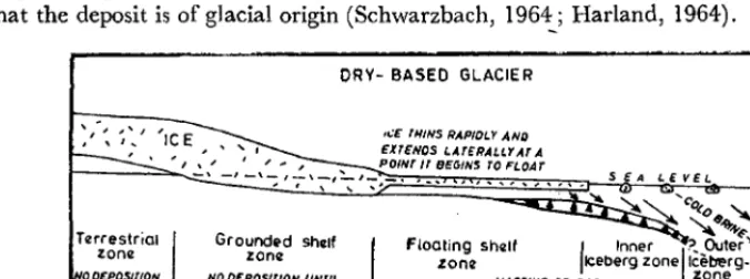
p. 817). Interbedded massive siltstone contains boulders at places as reported by Rupke. Although the phenoclasts are almost monomictic in Rupke's area, elsewhere they are reportedly polymictic (Auden, 1934, p. 376). These characters suggest, though do not prove,that the deposit is of glacial origin (Schwarzbach, 1964_; Harland, 1964).
DRY- BASED GLACIE R
',": ~:' ,.:E THINS RAPIOLY AND
, • , EKrENOS LATERALLY AT A
1-_ _ =-:"";:,,,' _ I _ \ _ ,~\_,~,_p!.'7r" BEGINS rOF'LOAr
Turestrial zon2
..
, \ ... 'Ground~d sh~lf
zonl! Floating zonl! Sh21f
... ~~'''~c "" ~6.ft",~
OOEPOS/TION UNTIL ICE MELTS
NO OEPOSIrION UNrtL ICE MELTS
I
Inner ~ Outer'" ICeberg zone Ilce~rg-_MASSIVE OR POORLY STR4TIFIE:Ozone
rtLL ~
I
COI.O BRINE:S FLOWDOWNSLOPE AND CAN OEPOSIT CARBONAJE: MOOIl'I£O AFTER CAREY AND AHMAD 119601
Figure 1. Glaciomarine sedimentation model to explain the deposition of the Blaini sequence.
2. The position of the Blaini deposits in a stratigraphic sequence (from? Nagthat through Krol) suggestive of a stable to moderately stable tectonic setting, presence Qf characters and rock associations unlike those found in ancient turbidite deposits Qr known geosynclinal belts and, above all, their vast areal extent (from Kashmir through Sikkim), are features considered as compelling factors in support of glacial Qrigin (Dott, 1961, p. 1302).
112 DISCUSSION
Figure 1 illustrates a possible depositional scheme for the Blaini deposits. The boulder bed was probably laid down by a dry-based glacier after it extended to sea in the outer part of the floating shelf zone; laminated dark fetid (sulphurous) silt-stone suggests in the iceberg zone in a barred basin environment (Carey and Ahmad, 1960, p. 887). The calcareous interbeds which are characteristic facies of a dry-based glacier suggest an environment saturated with calcium carbonate-solubility of CaCOa increases as the temperature of sea water drops towards zero. As the
carbonate solution (?brine) flows outwards into a warmer environment CaCoa is
inevitably precipitated (Carey and Ahmad,
op cit.,
p. 886). Occurrence of boulder components in a mass of siltstone mentioned earlier may possibly represent' drop stones '. Physico-chemical environment in iceberg zone indeed can give rise to local slumping and produce high density currents which could yield deposits like the contorted dolomitic limestone referred to earlier.Although the proposed glaciomarine model can explain conveniently the various features of the Blaini, and above all, its vast areal extent, much more work is needed before this mode of origin is finally accepted.
ACKNOWLEDGEMENTS
The writer acknowledges many thoughtful discussions with Professor F. Ahmad, Doctors V. K. Srivastava and N. Ahmad.
REFERENCES
AUDEN,
J.
B., (1934) The geology of the Krol belt. Rec. CIOl. Surv. India, Vol. 67, Pt. 4, pp. 357-454.BoUMA, A. H. and BROUWER, A., (Editors), (1964) Turbidites. Elsevier, Amsterdam, 264 pp.
CAREY, S. W. and AHMAD, N .. (1960) Glacial marine sedimentation.
CASSHYAP, S. M., (1969) Petrology of thr Bruce and Gowganda Formations and its bearing on the evolution of Huronian sedimentation in the Espanola-Willisville area, Ontario, Canada.
Palaeogeography, Palaeaelimatal. & Palaeaecol., (in press).
CROWELL,
J.
C., (1955) Directional current structures from the pre-Alpine flysch, Switzerland.Bull. Ceol. Soc. America, Vol. 66, pp. 1351-1384.
DOTT, R. E., JR., (1961) Squantunl" tillite ", Massachusetts--evidence of ancient glaciation or subaqueous mass movements? Bull. Ceol. Soc. America, Vol. 72, pp. 1289.1305.
HARLAND, W. B .• (1964) Critical evidence for a Great Infra-Cambrian glaciation. Ceol. Rundschau,
Vol. 54, Pt. I, pp. 45-61.
KUENEN, Ph. H., (1951) Properties of turbidity currents of high density. Soc. Econ. Pateontol. Mineral., Spec. Publ. 2, pp. 14-33.
PASCOE, E. E., (1959) A manual of the Ceology of India and Burma. (Vol. 1/). Govt. of India Pub!.,
pp.485-1343.
POTTER, P. E. and PETTIJOHN, F.
J.,
(1963) Paleoclltrents and basin analysis. Academic Press Inc.,New York, N. Y., 296 pp.
SCHWARZ8ACH, M., (1964) Critical for the recognition of ancient glaciation. In: A. E. M. Nairn (Ed.), Problems in Palatoclimalology, Int~rscience, New York. N. Y., pp. 81-85.
SCHERMERHORN, L. J. G. and SrANToN, W. 1., (1963) Tilloids in the West Congo geosyncline.
Quar/.Jollr. Ceol. Soc. London, Vol. 119, pp. 201-241.
DISCUSSIOl:\
Paper on " Dharwar conglomerates of Mysore-a restudy" by B. L. Sreenivas and R. Srinivasan published in the Journal (Vol. 9, No.2, Dec. 1968).
113
Comments by S. Varadarajan (Department of Geology, University College of Engineering, Bangalore) .
The following comments pertain to the tectonic conglomerates in general and Thattekere conglomerates in particular, in the above paper.
Sreenivas and Srinivasan (op. cit., p. 198) point out that" boudinization in which rocks of varying competencies are subject to compressive or shear type of deforma-tion" result" giving the rock a conglomeratic appearance". Regarding the conglo-merate of Thattekere they consider" the very rod shape of the pebbles and their restriction to a very narrow zone which does not exceed a maximum of five feet, are enough evidences of their tectonic origin" (p. 201).
In the Thattekere area, the conglomerate zone is not confined to a maximum width of 5 feet only. In the northern part of the '.\'estern band, where the quartzite trends NW-SE, the conglomerate zone varies in width from 15' to 50' for a strike length of nearly a furlong. Hence, while mentioning the criteria of tectonic conglo-merates, it is not correct to put a limit of maximum width of 5' to the conglomeratic zone.
Secondly, the rod shape of the pebbles is also not a unique feature of the tectonic conglomerates. Intensely deformed sedimentogenic conglomerates do show rodding
(Ramsay, 1967, p. 202).
What is important in the tectonic conglomerates, which the authors have missed in their restudy, is the disposition of the elongation of the rods with reference to the finite elongation the rock as such. In the tectonic conglomerates formed by boudi-nization, the elongation of the rods do not coincide with the maximum finite elonga-tion. The longest axes of the quartz rods are parallel to the intermediate axis of strain; whereas in the deformed sedimentary conglomerates the longest axes of the pebbles will be parallel (or subparallel) to the maximum strain axis (Ramsay, 1967, p. 201). This is also clearly indicated by petrofabric study (Varadarajan and Suryanarayana Setty, 1969).
In support of their view Sreenivas and Srinivasan state that" similar structures have been noticed by Ramsay (1956) and Hill (1963)". Ramsay clearly states that " the conglomerate structures are found wherever the thin granulite bands together with the matrix of semipelitic schist are contorted into small folds I I (p. 36). On the
other hand, Hill describes the formation of tectonic conglomerates by shear move-ment (p. 129). Neither move-mention the formation of conglomeratic structures similar to what the authors have stated.
REFERENCES
RAMSAY, J. G., (\956) The supposed Moinian Basal Conglomerate at Glen Strathfarrer, Inverness-Shire; Geol. Mag., V. XCIII, p. 32-40.
- - (1967) Folding and Fracturing of Rocks; l\kGraw Hill Book Co.
HILLS, E. S., (\963) Elements cif Structural Geology; Asia Pub. House.
114 DISCUSSION
Authors' reply
It is kind of Varadarajan to comment on our paper and to give us this -opportunity to elaborate our views on the origin of Thattekere conglomerates of
Holenarasipur schist belt.
From statements in para four and five of his discussion, it is apparent that he considers that Thattekere conglomerates are sedimentogenic later deformed, in support of which he draws our attention to his unpublished paper. While we eagerly look forward to this publication, we would like to emphasize our opinion on the origin of Thattekere conglomerates.
The quartz veins which have given rise to rodding structure are still noticeable in the form of veins in some exposures, e.g. in the region where the eastern conglomerate band shows
a
strike swing from NW to N70o-75°w. The vein traced south-eastward passes on producing rods. This clearly goes against any possible sedimentary origin. A cursory examination of quartz of the rods points to its yidding more plastically as. compared to the quartz of orthoquartzite matrix which has yielded by crushing. According to Wilson (1953) as quoted by DeSitter (1956), l'Ods develop from quartz. that has been introduced into or has seggregated in the rocks. According to De Sitter (1956; p.90) rodding is developed commonly in incompetent material enclosed in a competent matrix, which is clearly evidenced by the above characters of rod and vein quartz of the Thattekere conglomerates.Varadarajan has questioned our using the term" rodding" exclusively to the tecto genic conglomerates stating that the pebbles in sedimentary conglomerates can produce « rodding" by deformation. He further quotes Ramsay 1967, p.202) in
support of his contention. However it is clear from Ramsay's caption for Fig.5-lS on that page that he makes use of the term" rod like pebbles" which in our opinion would not have been done unIntentionally, in view of the fact that the term " rodding" has an independent status in geologic literature. Ramsay apparently used" rod like pebbles" in view of the fact that the matrix is incompetent, which Varadarajan has perhaps misunderstood for rodding.
Regarding the orientation of the pebbles, it may briefly be stated that the parentage of the conglomerate-sedimentary or otherwise-has little influence. Several rheologic factors play an important role. It is beyond the scope of the present discussion to go into all the details.
Having shown that Thattekere conglomerates of Holenarasipur are tectogenic, we now turn to some general remarks of Varadarajan. He has misunderstood us as. having said that all tectogenic conglomerates of Dharwars of Mysore State are produced by boudinization, whereas it has not been our intention. Though we could not give detailed information on individual conglomerates (v,hich we hope to publish} in a broad survey of all Dharwar conglomerates as was attempted in our paper, we have not neglected to merit the peculiarities of individual conglomerates and it was. due to this, we clearly mentioned that the Thattekere conglomerates are roddings. while the K.G.F. conglomerates are due to boudinization. It would not be correct of Varadarajan to put boudinization and Thattekere conglomerates together.
DISCUSSION liS
15 to 50 feet wide in the western band, it would not in any way disprove the tectonic origin for the Thattekere conglomerates, for many tectogenic conglomerates have widths measuring hundreds of feet.
Varadarajan is right in quoting us as having compared the conglomerates showing compositional layering with the structures noticed by Ramsay (1956) and Hills (1963). The comparison has not included Thattekere conglomerates at all. Com-parable structures are mainly in the multicomponent tectogenic conglomerates (eg. K.G.F). Though the alignment of pebbles in plan and confinement to a plane was recognised by Hills (op. cit) it is the authors who made use of the term" composi-tional layering" for which they take full responsibility. As to the part played by shear, which Varadarajan envisages as the mechanism postulated by Hills, it is clear from our description of K.G.F tectogenic conglomerates which fall within the major fault zones of the area, that shear has really been the dominant factor in boudiniza-tion and subsequent development of conglomerates with composiboudiniza-tional layering.
REFERE:-ICES
DESITTER, L. U., (1956) Structural Ceology: McGraw Hill Kogakusha (International Student En.) 552. pp.
HILLS, E. S., (1963) Elements of Structural Ceolo!!y: Asia Publishing House.
RAMSAY,
J.
G., (1956) The supposed Moinian basal conglomerate at Glen Strathfarrar, Inverness-Shire: Ceol. Mag., Vol. XCIII, pp. 32-40.- (1967) Folding and/racturing of rocks: McGraw Hill, 568 p.