Traffic Impact Analysis
1
G.Divya Sri &
2K.Sai Krishna
1. ASSISTANT PROFESSOR Bomma Institute of Technology and Science,Allipuram, Khammam, Telengana, INDIA - 507318
2. M.Tech, Bomma Institute of Technology and Science,Allipuram, Khammam, Telengana, INDIA – 507318
ABSTRACT :
Understanding the demands placed on the community’s transportation network by development is an important dimension of assessing the overall impacts of development. All development generates traffic, and it may generate enough traffic to create congestion and to compel the community to invest more capital into the transportation network, whether it is in the form of new roads or traffic signals or turn lanes. Traffic congestion results in a number of problems, including economic costs due to delayed travel times, air pollution and accidents. As one roadway becomes congested, drivers may use others not necessarily intended for through traffic. As a result, traffic impact analyses are becoming more common as a planning tool to fore-see demands on the transportation network and to mitigate any negative impacts. Besides, understanding traffic impacts becomes even more important as budgets for public facility and infrastructure improvements become increasingly strained. In order to reduce the traffic congestion there is a need of traffic impact analysis (TIA) on critical locations of the road network. The traffic impact analysis is a useful tool for early identification of potential traffic problems and shall play an important role for finding the practical solution.
Key Words — Urban development; traffic congestion; travel times; economic cost
INTRODUCTION:
One of the fundamental aspects of transportation planning is the interdependency of land use and transportation. The pattern of land use is affected by the level of accessibility provided by the existing transportation system. Any new development leads to the production or attraction of trips and thus creates new travel demands. Hence there is a need for improvement of the existing transportation facilities either in the form of new infrastructure or in the form of
improved operational conditions. Such
improvements, in turn, make the land more accessible to the existing activity centers and the attractiveness of the land increases. This spurs
new development, and the cycle starts again. This process continues until some kind of equilibrium is attained.
The urban transportation system is the engine of the economic activities in all- urban
communities all over the world, and
urban centers. In recent times, many cities have seen a large increase in road traffic and transport demand, which has consequently lead to
deterioration in capacity and inefficient
performance of traffic systems. In the past, it was thought that in order to resolve the capacity problem it was simply to provide additional road space. This was the main strategy applied in the U.S.A at the wake of 1960’s and 1970’s. A lesson learnt from this strategy is that adding capacity alone is ineffective because it induces travel growth that negates the benefits of
highway expansion. Moreover, there is
complexity in so doing for one reason that most cities are already built-up areas, hence it is difficult to carry out any substantial expansion works. In practice, it may be neither socially nor economically acceptable to balance supply and demand solely by increasing road capacity. Although the expansion of road infrastructure is not absolutely ruled out as the demand may be expected to continue to grow by time, the immediate, most relevant and acceptable strategy to mitigate capacity problems and increase efficiency of the road network is through traffic management applications. The most recent approach that has gained prominence in traffic management operations is the
introduction of Intelligent Transportation
Systems (ITS). Such technologies help to monitor and manage traffic flow, reduce congestion, provide alternate routes to travelers and increase safety. These systems have made significant success in major cities of many developed countries of America, Asia and Europe. For most cities of the developing countries, they have yet to realize these benefits, primarily due to economic and technological constraints.
On the other hand, the familiar tools (which are considered traditional) that are applied as traffic and demand management tools in order to increase the efficiency of the transport system include and not limited to: prioritization of road users (i.e. introduction of truck lanes, bicycle and pedestrian routes, peak lanes, etc.), road hierachisation (i.e. classification of road function), road markings and signs, enforcement devices (i.e. camera, police patrol, etc.), regulation of parking space, congestion charges, fuel prices, traffic restraints (i.e. limiting entry to city centre, Pedestrization of city centre, etc.), improvement of public transportation, etc. These
tools are relatively cost- effective and
technologically affordable and are applicable both in developing and developed countries. However, much as they may seem affordable, yet they are not effectively implemented in most developing countries. A good example is how
traffic management is implemented by
application of road hierarchy regulations. A hierarchical road network is essential to maximize road safety, amenity and legibility and to provide for all road users. Each class of road in the network serves a distinct set of functions and is designed accordingly. The design should convey to motorists the predominant function of the road. For example there is a broad division between arterial and non- arterial (or local) roads. Basically arterial and local roads make the backbone of most urban road networks. Arterial roads are important transport routes that are designed for high traffic volumes and high speeds (i.e. through traffic movement), whereas
local roads are essentially intended for
exhibit deteriorated capacity and poor performance.
PROBLEM STATEMENT.
The traditional methods for design and operational analysis of highways and urban streets is the American Highway Capacity Manual (HCM 2000). The procedures and methodologies of this manual evolved from a wide range of empirical research conducted in the USA since the 1950’s. Through the years it has evolved to address the needs of a much wider audience including specialists such as environmentalists (i.e. air quality and noise experts). However these procedures were developed for typical conditions found in developed countries where traffic is more homogeneous and regulated. Consequently, they cannot be applied successfully in traffic conditions that are significantly different such as those prevalent in most developing countries. In Dar-es-salaam for example, the amount of disturbance to traffic flow from side friction is often considerable and the number of sources of friction is also large. They include: vehicles stopping, parking, loading and unloading
(particularly public transport vehicles),
non-motorized vehicles (including bicycles), pedestrians walking in the roadway and crossing, street trading, the number of accesses and the number of vehicles using them. In consequence, traffic flow is considerably interrupted, and thereupon diminishing the performance of traffic
operations and undermine capacity and
functional integrity of the road. Most of these factors are not explicitly addressed by methodologies evolved in developed countries for planning, design and analysis of roadways. It is thus intended in this study to characterize all significant variables, which influence traffic
operations, but are otherwise not directly addressed by the familiar tools such as the Highway Capacity Manual (HCM 2000).
PURPOSE FOR TRAFFIC IMPACT
ANALYSIS
A. Operational Conditions
To ascertain the operational conditions on the adjacent roadway network when a proposed development is accommodated within the existing transportation infrastructure
B. Proposed Development
To determine whether access to the proposed development will hamper traffic operations and safety near the site.
C. Future transportation
To identify present or future
transportation system deficiencies without the new development Thus it is useful in confining
the uncontrolled and haphazard developments.
When is a Traffic Impact Study Required?
A Traffic Impact Study report is typically required where a proposed development may impact the transportation network, including the road, transit route, cycling and pedestrian components.
For these situations, as well as when a proposed
land use is considered as-of-right, a
transportation impact study is required when:
1. The proposed development is
2. The proposed development is anticipated to generate less than 100 vehicle peak hour trips, however, the site or study area characteristics are
such that traffic or other
transportation issues or concerns may have to be addressed to accommodate the development.
It is also recognized that developments may not proceed as originally planned for a variety of reasons. Should the proposed development remain dormant for two years or more, i.e., the application process has become inactive, it will be necessary to update the traffic impact study to address any changes in either the development proposal or study area transportation conditions.
Pre-Consultation
Prior to the undertaking of a traffic impact study, pre-consultation is required between the Region and the applicant’s consultant. The intent of the pre-consultation is to discuss the development proposal, relevant issues pertaining to the type of development or its location, establish the scope of study required, and to confirm acceptable study parameters.
The format for pre-consultation will depend in part on the scale of the development proposal, the proposed land use and its likely traffic impacts, and may include a phone discussion, email exchange, or a meeting. A checklist of discussion items is provided in Section 3 of these guidelines to provide structure to the pre-consultation, and to serve as the basis for the requirements of a particular transportation impact study.
The Region may accept study findings
and recommendations even where
consultation has not occurred, but omitting pre-consultation is likely to result in a need for multiple revisions, and resubmissions, which can greatly extend the review process.
Required Qualifications
As part of the pre-consultation exercise, the applicant’s consultant should be prepared to demonstrate the experience and expertise that both the firm and the individual acting as project manager have in the field of transportation and traffic engineering and the preparation of traffic impact studies. In the event that the consultant lacks the prerequisite experience, the Region would require that the applicant retain a new qualified consultant, or possibly a qualified sub-consultant to assist the original sub-consultant. The latter case would address situations where the original consultant is providing other services within their field of expertise to the applicant.
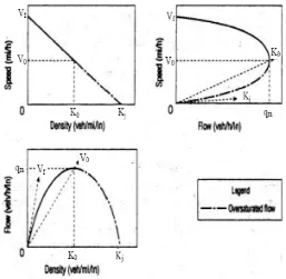
A REVIEW OF CLASSICAL SPEED-FLOW-DENSITY RELATIONSHIPS AND FACTORS AFFECTING THEM.
Since 1930s, perhaps beginning with the pioneering works of Green shields (Green shields, 1935) an immense amount of literature has been produced on the relationships between the speed, flow and density of traffic and the factors affecting these relationships. A review of this literature in full is not warranted here, because the prime objective of this research is concerned with friction, not with extending knowledge of these theoretical relationships. Nevertheless, some review of the standard theory is appropriate. The main three parameters, which describe uninterrupted traffic stream, are Flow,
Speed and Density. The generalized
representation of their relationships, which are
the basis for the capacity analysis of
uninterrupted-flow facilities are shown in figure 2.1 below (HCM 2000, Exhibit 7-2). The importance of understanding the relationship
between flow, speed and density is
unquestionable. From the standpoint of design, knowledge of high flow rate characteristics is required for the prediction of highway capacity. From the standpoint of traffic operations, understanding the entire range of relationships is important to provide adequate level of service. Tasks such as development of flow control and ramp metering techniques must be based on these functional interrelationships under high- density conditions. Moreover, any efforts toward
developing new roadway and vehicular
technologies for the purpose of improving flow characteristics will necessarily stem from an understanding of the present relations. In general, speed-flow-density relationships are useful for highway design and planning process as they
provide quantitative estimates of the change in speed as a function of anticipated changes in traffic demand. They are equally useful in real-time traffic control or incident detection based on changes in traffic flow parameters.
Figure 2.1 Generalized relationships among speed, density, and flow rate on uninterrupted-flow facilities (source HCM 200)
diagrams. Between these two extreme points, the dynamics of traffic flow produces a maximizing effect. As flow increases from zero, density also increases, since more vehicles are on the roadway. When this happens, speed declines because of the interaction of vehicles. This decline is negligible at low and medium densities and flow rates. As density increases, these generalized curves suggested that speed decrease
significantly before capacity is achieved.
Capacity is reached when the product of density and speed results in the maximum flow rate. This condition is shown as optimum speed Vo (often called critical speed), optimum density Ko (sometimes referred to as critical density), and maximum flow qm.
The slope of any ray line drawn from the origin of the speed-flow curve to any point on the curve represents density, based on this equation: K = Q/V, where: Q = flow rate (veh/hr)
V = average travel speed (km/hr), and
K = density (Veh/km)
Through empirical research HCM 2000 has documented speed-flow models for typical uninterrupted and interrupted-flow segments on different types of facilities, i.e. freeways, multilane highways, two-lane highways and urban arterial streets of different classes as shown on figure 2.2 below. It is indicated that different road facilities reflect different speed-flow characteristics. Un-interrupted facilities are usually characterized by high Free- Flow Speeds (FFV), which are sustained at the same level during low volume traffic flows until near
capacity, while interrupted facilities are
characterized by low Free-Flow Speeds (FFV) whereby the travel speeds are sensitive to traffic
flow volumes and other variables including signal density, and urban street class.
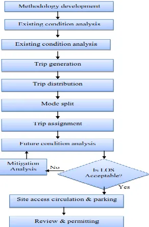
TRAFFIC IMPACT ANALYSIS FLOW CHART
In order to have brief study on the impact
of the traffic a basic frame work for site impact analysis is shown in Figure . In general, all site impact analysis and reviews can be followed this set of basic procedures.
Figure Flow chart for traffic impact analysis
The analysis can be done Pertinent
Existing Roadway Information, Existing
intersection Geometry, Existing Traffic
Volumes, and Existing Level of Service.
Trip generation.
basic steps should be followed in determining the appropriate trip generation rate:
1. Check availability of local trip generation rates for comparable sites.
2. Local data for similar developments are not available, conduct trip generation studies at sites
with characteristics similar to those of the proposed development.
3. Check national sources for an applicable range in trip rates.
4. Determine the design level of traffic to be utilized for the analysis and select appropriate rates.
5. Determine any adjustments that may be applied to trip rates to account for the specific characteristics of the development
6. Select the most appropriate trip generation rate
Trip distribution models
The purpose of trip distribution is to analyze the trip making characteristics between the Proposed development and off-site areas. The total trips generated by the development must be distributed and assigned to the road network.
Analogy method:
One of the most commonly applied manual trip distribution methods used in site impact analysis to base the trip distribution on existing data collected at sites that are similar to the subject development. This data is usually traffic count and turning movement information
Gravity model:
Gravity model is a well known synthetic models based on Newton‟s concept of gravity
proposed by Voorhees (1956). The gravity model assumes that the trips produced at an origin and attracted to a destination are directly proportional to the total trip productions at the origin and the total trip attractions at the destination. The calibrating term or „Friction Factor‟ represents the reluctance or impedance of a person to make the trips of various duration or distances. The standard form of gravity model is given by
Where
T ij = trips from zone i to zone j
Ff ij= friction factor (adjustment factor) for zone
pair ij
P i = productions in zone i
Aj = attractions in zone j
Traffic count based distribution model:
no land-use information is available, such as in developing countries.
Mode split
Mode split is the process of estimating the number of travellers between zones that are anticipated to use modes other than automobiles in site impact analysis
Traffic assignment
Trip assignment involves estimating the amount of generated traffic allocated to the alternative routes on the road network. The product of this process is the total number of development generated trips by direction and turning movement on each segment of the study area road network
Future condition analysis
The purpose of the analysis of future conditions for site impact analysis is to determine the impact of trips generated by the development on the performance of the transportation system. Development-generated trips are evaluated to determine if the impacts are significant and adverse.
Mitigation measures
Mitigation of impacts shall be required if the proposed development would cause a facility or traffic movement to exceed LOS-D. Acceptable mitigation measures shall include:
1. Staging of development in order to relate site development to the construction of the required
Thorough fare system.
2. Off-site improvements, including the provision of right-of-way and/or the participation in funding for needed thoroughfare and intersection improvement Projects.
3. On-site improvements, including access controls and site circulation adjustments.
Level of Service and Capacity Analysis
When the proposed development and other developed projects at the vicinity of the study area which generates the traffic more than the required level of service and capacity their analysis is to be done.
Site access, Circulation and Parking
The goal of access management is to ensure the safe and efficient flow of traffic through the road system and access to their destination by limiting the number of conflict points, separating conflict points, and removing turning vehicles and queues from through traffic.
Review and Permitting
The final step toward site impact analysis
approval is agency review and permitting. All site impact analysis and review should undergo a review and permitting process where all appropriate agencies and department divisions are allowed to comment on the site impact analysis. The department’s review shall address the impacts of the proposed development on the significant roadways.
Regression analysis
Both linear regression and logarithmic regression equations can be used to derive the relationships between trips generated and the independent variable. If redevelopment is analyzed then the analysis should consider the traffic associated with the existing development for comparison purposes
CONCLUSION
A traffic impact analysis is a study which
assesses the effects that a particular
complexity depending on the type, size and location of the development. Traffic impact studies should accompany developments which have the potential to impact the transportation network. They are important in assisting public agencies in making land use decisions. These studies can be used to help evaluate whether the development is appropriate for a site and what type of transportation improvements may be necessary.
Traffic impact studies help community to:
1.Forecast additional traffic associated with new development, based on accepted practices.
2. Determine the improvements that are necessary to accommodate the new development.
3.Assist communities in land use decision making.
4.Assist in allocating scarce resources to areas which need improvements
Identify potential problems with the proposed
development which may influence the
developer’s decision to pursue it.
5. Allow the community to assess the impacts that a proposed development may have.
6. Help to ensure safe and reasonable traffic conditions on streets after the development is complete.
7. Reduce the negative impacts created by developments by helping to ensure that the transportation network can accommodate the development.
8. Provide direction to community decision makers and developers of expected impacts.
Protect the substantial community investment in the street system.
Reference
[1] Soumya S. Dey and Jon D. Fricker. (1993). ―A proposed three step process for traffic impact analysis in Indiana.‖ ITE Journal. 19-22
[2] Department of Public Works, Country of Los Angeles, USA,‖Traffic impact analysis guidelines‖
[3] Proposed Philippine traffic impact assessment guidelines.
[4] Akcelik, R. (1981). Traffic Signals: Capacity and Timing Analysis. ARRB Research Record 123, Australian Road Research Board.
[5] Algers, S., E.Bernauer, M.Boero, L.Breheret, C.Di Taranto, M.Dougherty, K.Fox, and J.F.Gabard (1997). ―Review of Micro-Simulation Models.‖ Review Report of the SMARTEST project,
deliverable 3
(http://www.its.leeds.ac.uk/smartest/deliv3.html)
[6] Aronsson, K.F.M., and Bang, K.L. (2005). Factors influencing speed profiles on urban streets. 3 rd International symposium on highway geometric design, Illinois Chicago. Compendium of papers CD-ROM.
[7] Bang, K.L., Ronggui, Z., and Huichen, X., (1988): Traffic performance and passenger equivalents for road links and township roads in Peoples Republic of China. Proc., Third International Symposium on Highway Capacity,Copenhagen, June 1998 (TRB + Danish Road Directorate)