S.L. (Simon) Janssen, s1009877
UNIVERSITY OF TWENTE.
DECEMBER 7, 2015
Assessing the
perception of
drones in the
construction
industry
Author
S.L. (Simon) Janssen
E-mail: [email protected] Phone: +31 (0)6 301 65 117
Postal address: Mina Krusemanstraat 33 7513 HA Enschede
Educational institution University of Twente.
Faculty
Constructional Technical Science, Construction Management & Engineering
Supervisor
dr. ir. A.G. (Bram) Entrop
Preface
In front of you lies my report of the research conducted about the acceptance of drones in the construction industry. The report was written as my thesis for the Bachelor Civil Engineering as an internal assignment to the Department of Construction Management & Engineering of the University of Twente.
Sustainable building has always been a discipline I have been interested in. When I heard about plans to introduce drones in the construction industry I was immediately interested. The concept is very new to the construction industry and the process of implementation is in its early stages. This research will give insight in the willingness of the construction industry to implement drones such that an implementation plan could be made for drone technology. The research functions as a base that will hopefully support the implementation of drones in the construction industry as part of the 3TU Lighthouse Research Project "Throw in the i-Drone”.
For making it possible for me to finish this research and report I would like to thank some people. First I would like to thank my parents and girlfriend, who always supported me, kept encouraging me and never stopped believing in my potential. Then, I would especially like to thank my supervisor dr. ir. Bram Entrop for all the support and feedback during the research. He also has my great appreciation being the encouraging mind behind the bigger “Throw in the i-Drone” research project.
Simon Janssen
Enschede
Summary
This research is done as an internal research project at the department of Construction Management & Engineering of the University of Twente and has drones in the construction industry as its subject.
Drones can be used for several applications, but they have not been implemented in the construction industry while they might improve the construction process on several levels.
Unmanned Aerial Vehicles, better known as ‘drones’ are aircrafts that can be remotely controlled or even fly autonomously. The drones that this research discusses are multi-copter drones that can fly and hover in the air with the help of multiple rotor blades. Drones are often equipped with camera’s making them ideal for visual inspections. The research conducted will serve as the base of another research that will try to make the construction industry enthusiast to implement drones in that industry.
The goal of this research is to provide more insight in what is necessary to encourage the construction industry to implement drones. This will be achieved by answering the main research question: “What is the perception of the application of drones in the construction industry?”.
In order to answer this question it was first researched what drones could do in the construction industry. This is mostly with the use of cameras. One of these applications of drones could be conducting visual inspections of objects at height while the operator is safe on the ground. This is not only safer, it is also a lot faster than sending an inspector to a roof. The potential users of the research were found to be contractors, local governments and consultancy agencies.
After the literature study a survey and interviews were put together. The questions asked in the survey were based on the outcome of the literature study. The survey was spread under the potential users found earlier in the research. In order to get good insight in what the potential users of drones expect drones to do there were also three interviews conducted.
Table of contents
Preface ... 2
Summary ... 3
1. Introduction ... 6
1.1. Drones in the news ... 6
1.2. Motivation for the research ... 6
1.3. Scope of the research ... 6
1.4. Reading guide ... 7
2. Research setup ... 8
2.1. Problem definition ... 8
2.2. Goals of the research ... 8
2.3. Research questions & research method ... 9
3. Drones and their applications ... 10
3.1. Drones ... 10
3.2. Applications of drones available now ... 11
3.3. Applications of drones available in the near future ... 13
3.4. Preliminary conclusions ... 14
4. Drones and their users ... 15
4.1. The potential users of drones... 15
4.2. Advantages/disadvantages for the potential users of drones ... 16
4.3. Preliminary conclusions ... 18
5. Empirical data perceptions drone usage ... 19
5.1. Developing a survey ... 19
5.2. Data collected by the survey ... 20
5.3. Developing interviews ... 21
5.4. Data collected by the interviews ... 21
6. Expectations of drones ... 24
6.1. The expected applications of drones ... 24
6.2. Expected advantages/disadvantages of drones ... 25
6.3. Valuation of drones ... 26
6.4. Preliminary conclusions ... 27
7. Analysis ... 28
7.1. Applications of drones ... 28
7.2. Advantages/disadvantages ... 29
9.1. Conclusions ... 32
9.2. Recommendations... 33
References ... 35
Appendix A: Survey – Innovation in the construction industry ... 37
Appendix B: Meeting & interview company K & company L ... 42
Appendix C: Interview company M ... 46
1.
Introduction
Unmanned Aerial Vehicles (UAVs) or better known as ‘drones’ are aerial modules that are operated by a manned remote or by a predetermined flightpath. Since the invention of the drone it had been utilised and developed mainly by militaries. But nowadays drones in the form of multi-copters are more accessible to general people and therefore can be used by companies in a very wide array of tasks. More detailed information about what a drone is can be found in section 3.1.
This chapter will include some occasion drones were in the news, the motivation that lead to this research, the scope of the research and a reading guide for the report.
1.1.
Drones in the news
Nowadays drones are also very often the subject of news headlines. For example the TU Delft has developed an ‘Ambulance-drone’ that sends a drone equipped with a defibrillator to a victim of cardiac arrest (TU Delft, 2014). But drones are also used in other disaster scenario’s. A drone has also been used by the Dutch government to investigate the cause of an incident of a fallen construction crane in the middle of a residential area in Alphen aan den Rijn in the beginning of this month (Algemeen Dagblad, 2015). During the SAR Katwijk a drone has been used for demonstrational purposes to show the public that drones can be used for Search And Rescue missions above sea to find castaways (Demonstratie inzet drone bij het opsporen van drenkelingen tijdens SAR Katwijk, 2015).
1.2.
Motivation for the research
In order to implement drones in the construction industry there needs to be support for the concept. Because the concept of utilising drones in construction industry an implementation plan is needed. In order to get to that implementation plan there is a need for information about the concept and the perception and knowledge the construction industry has regarding drones. To gather that data and gain insight in the current perception of the usage of drones and knowledge about drones in the construction industry, this research was conducted.
1.3.
Scope of the research
As stated above the study will be about gathering insight in the opinions of companies in the construction industry regarding the utilization of drones in the construction industry. Writing a plan about how drones should be implemented is not included in this study, recommendations about the core elements such plan should contain is. Further because of the enormous amount of company types and possible users of drones in the construction industry not all will be included. The most important and likely users will have to be found in advance and the unlikely users will not be part of the next steps in this study.
1.4.
Reading guide
This research report will start in chapter 2 with the explanation of the setup of the report. This will include the problem definition and goals that form the base of the research. The research method is given here as well. With this the framework for the report is formed which gives the outline for the rest of the report.
Chapter 3 will give an overview of what a drone is and what the most important parts of a drone are. This makes the report understandable for the readers that do not know anything about drones. After this chapter 3 gives the applications that drones can be used for, divided in the applications that are currently available and applications that will be available in the future.
Chapter 4 will give insight in the potential users for drones, these users are selected from a list of stakeholders involved in a construction project. The advantages and disadvantages of drones for these potential users will also be assessed in this chapter.
In order to gather empirical data a survey and interviews were conducted. Chapter 5 gives how these methods were put together and what their results were. After this chapter 6 will give the expectations the potential users found in chapter 4 have for drones. This is done by giving the possible applications and stating what their advantages and disadvantages were according to the results given in chapter 5.
A comparison of the results found by chapters 3 and 4, and the results of the empirical data given in chapter 6 will be made as the analyses of the data collected. This will be chapter 7.
Chapter 8 will contain the discussion regarding the research, this includes the findings the researcher found during the research and what went right and wrong with the research. It also includes what the researcher thought of drones before the research and whether this was changed due to the research.
2.
Research setup
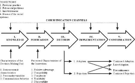
[image:9.595.74.525.169.448.2]The idea of using drone technology in the construction industry is perceived as new and therefore deserved to be titled an ‘innovation’ (Rogers, 1983). But for such an innovative concept to be actually implemented in such a complex industry with an enormous amount of company types one has to know whether the market is ready for it and in what form the concept could best be launched in the field.
Figure 1: A model of stages in the innovation-decision process. (Rogers, 1983)
2.1.
Problem definition
Rogers (1983) gives that the stages an innovation has to go through are as in Figure 1. So to get actually implemented in the industry, knowledge has to be gathered in order to persuade the users they should decide to implement the drones in their business. This means that, in order to implement drone technology in the construction industry, the innovation has to go through these stages. At the moment of the research drones have not been used in the construction industry. Information about what drones could do for the construction industry, the stakeholders involved and what these stakeholders want in order to be persuaded to decide to implement drones in the industry, is not available yet. So in order encourage the construction industry to implement drones this information needs to be gathered.
2.2.
Goals of the research
2.3.
Research questions & research method
In this section the study questions, and the method that will be used to answer them will be explained. It gives the framework for the research that will be followed in order to achieve the set goal: provide more insight in what is necessary to encourage the construction industry to implement drones.
The main question to be answered is as following:
What is the perception of the applications of drones in the construction industry?
This question is interesting to science because when answered it gives us the possibility to adapt the drone technology to a level that drones will be accepted and in the near future drones will be implemented in the construction industry.
When this question will be answered one could form a plan to make the likely users of drone technology enthusiast and make sure they will be persuaded to make the decision to implement drones in their business. Therefore, the attributes given by Rogers (1983) for the persuasion stage will be used throughout the research.
To get a clear answer to the research question sub questions will help structuring the research and keep a clear overview.
These sub questions are:
1. For what purposes can drones be used? 2. Who are the potential users of drones?
3. What would the users of drone technology expect from this technology?
Questions 1 and 2 will be answered with a literature study, the results will be compared to the results of the survey and interviews. Question 3 will be answered with the help of a survey and interviews.
1. For what purposes can drones be used?
As mentioned drones gain in popularity due to their vast amount of possible utilities. In order to answer this question a proper description of a drone is given. After this the applications drones could have in the construction industry is split in two sections. Applications available now, and application that will be available in the future. The methodology to get to an answer to this question is through a literature study.
2. Who would be the potential users of drones?
To find the potential users for the applications that are found list of stakeholders involved in construction project given in ‘Managing Construction Projects’ by Winch (2010). A selection of these that could be interested in drones are picked from this list. These stakeholders are the potential users of drones and will be described. Then the advantages/disadvantages of drones for these potential users are given.
3. What would the users of drone technology expect from this technology?
3.
Drones and their applications
Drones gain in popularity due to their vast amount of possible utilities and increased availability to the general people. In this section a proper description of a drone is given such that it is known what is actually talked about in this report. Then the applications drones could have for the construction industry are given. This will be split in the applications that are available now and applications that could become available in the future. The information gathered here will eventually be used to draw preliminary conclusions that can be used to answer sub question 1.
3.1.
Drones
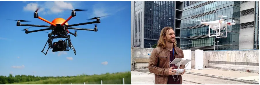
The drones covered in this research are multicopter drones. This means the drone has four or more rotor blades that give it the ability to fly and hover (like a helicopter) in mid-air making it the ideal platform for shooting aerial imagery. This is what drones are being used for most often, shooting aerial imagery. Nowadays drones get cheaper and consumers can buy a higher end quality drone like the DJI Phantom 3, shown on the right in Figure 2, for about €1,399 (DJI, 2015) depending on the version bought. The most high end version of this drone looks the same as the others but has a better camera. This is the drone shown in Figure 3 as an example in order to indicate the most important parts a drone exists of and what these components functions are.
Such a drone is equipped with an integrated high definition camera mounted on a three dimensional gimbal which stabilises the camera to get better imagery results. These drones deliver great quality images and movies for a reasonable price if one would be a hobby enthusiast. The drone can even fly autonomously using a pre-determined flight plan. The images recorded can be shown on a mobile device such as a smartphone or tablet.
A professional drone such as the HT-8 by Height Tech, shown on the left side of Figure 2, will use about the same type of parts, but these drones are custom made to the wishes of the customer and are built to be used a lot more than the DJI drone. They often offer more options and exceed the consumer drones in about every aspect. They can fly higher, faster, with heavier loads, more precision and in worse weather compared to consumer drones. The gimbal is one of the most important parts for enabling smooth capturing of imagery. Diaz (2015, p.39) calls it “the weakest link in the system”. The drone can be as professional and high and as someone wishes, but without a good quality gimbal the imagery will not be as smooth as wanted.
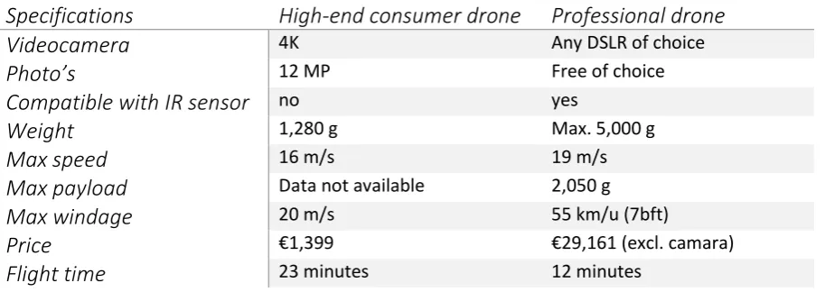
[image:11.595.73.526.424.573.2]This type of drone however requires special paperwork because it is heavier than 4kg (NOS, 2014), it also requires a theoretical and practical exam.
Figure 3: Example drone with the parts explained
A comparison of the DJI Phantom 3 ‘Professional’ as a high end consumer drone and the professional HT-8 by Height Tech is made in Table 1.
Table 1: Drone comparison (DJI, 2015 & Height Tech, 2015)
Specifications
High-end consumer drone
Professional drone
Videocamera
4K Any DSLR of choicePhoto’s
12 MP Free of choiceCompatible with IR sensor
no yesWeight
1,280 g Max. 5,000 gMax speed
16 m/s 19 m/sMax payload
Data not available 2,050 gMax windage
20 m/s 55 km/u (7bft)Price
€1,399 €29,161 (excl. camara)Flight time
23 minutes 12 minutes3.2.
Applications of drones available now
An application of drones according to Floreano and Wood (2015) is to use a drone to inspect structures for cracks and leaks. Drones equipped with regular cameras make it possible to visually observe places that are hard to reach for a person. One could think of rooftops or other elevated surfaces. These observations can be done by a person, but this means a high risk and therefore an often costly operation needs to be set up. In The Netherlands the Euronorm for working at altitude is used. This says a worker needs to be secured above a height of 2.5 meters (EU richtlijn werken op hoogte, 2015). Inspection with a camera drone can be done from the ground, which could lower the costs and danger of an inspection at high altitude.
[image:12.595.73.530.381.543.2]Service are trying to apply drones with infrared equipment to monitor wildfires and smouldering hot spots (Freeman and Freeland, 2014).
Thermography makes it possible for an audit of an existing building (Balaras & Argiriou, 2002). With infrared cameras one can detect areas that are or could become a problem for the building integrity before they become serious problems that are costly to repair. Thermography makes it possible to inspect electromechanical installations for flaws. Wet spots in a wall or roof can also be detected using thermal images. This is useful for someone who is selling or buying a building, or for example in a renovation project. Take a house as an example. When a property developer is buying a building in order to revise it and sell it with a profit, leaking plumbing that needs to be repaired can seriously harm his revenue of the project. A building integrity report is often required before one buys a building. Those thermal readings are done primarily inside the building. Evidently it is more appropriate to do this type of indoor inspection with a handheld thermal camera instead of a drone for residential buildings or offices. But a drone could be useful when properly inspecting large factory halls where walls and roofs are out of reach of the handheld cameras without additional equipment. Drones are becoming more and more controllable such that they can be flown indoors with the proper training and experience with the drone.
Measuring weak spots (moisture) in concrete structures is another possibility with thermal images retrieved from an IR-drone. This could mean flying over a hardened or hardening concrete foundation in order to scan the concrete for heat or cold spots that could indicate moisture leaks from cracks in the foundation as a result of leaks in the plumbing. Figure 4 shows a thermograph from a floor where one could clearly see the plumbing underneath the surface which would be invisible to the naked eye. Malfunctioning electrical circuits also produce heat that can be detected with the IR-drone. These malfunctions are often the cause of fires in buildings so finding them could be lifesaving.
What could also be done with thermography is the inspection of photovoltaic panels (Pilla, Galmiche & Maldague, 2002). These often called ‘solar panels’ are growing in popularity because they produce electricity without using fossil fuels. These solar panels are costly to buy but more and more often come with a subsidy because governments pay a lot of attention to environmental friendly energy sources. The photovoltaic panels pay back their value in about 10 years and after that period they often start making money for a household. This makes them an interesting investment for the common people and caused the growth in popularity.
[image:13.595.71.354.542.717.2]Thermography can also be used to inspect the envelope of a building. This is one of the main applications of thermography. The building is often heated to the temperature that it will be when in use and temperature readings of the envelope of the structure are done. With this type of inspection heat losses can be detected. These heat losses indicate a flaw in the insulation of the building via air leakage or thermal bridges. For newer buildings which are meant to be properly insulated this often Figure 4: Thermograph of an underfloor hot water supply and return pipes
of the building. A window could be wrongly installed or insulation is placed improperly causing it to sag. Scanning the building after finishing its construction with an IR-drone could make it possible to find these errors and fix them before the building is yielded to the client. This could prevent costly compensation claims afterwards.
Drones are already being used to gather data for polar research, volcano studies and wildlife biology. They become indispensable and revolutionary technology (Marris, 2013).
3.3.
Applications of drones available in the near future
Drones equipped with regular cameras can be used to check whether the maximum amount of built surface is not exceeded. This would be based on the potential drones have “to collect detailed geospatial information in real time at relative low cost” (Fornace, Drakeley, William, Espino & Cox, 2014, p. 514).
[image:14.595.82.427.497.727.2]Construction site management could be assisted by data gathered by drones. This could include tracing building materials’ locations on site. The visual system of a drone will be co-operating with classifier software that identifies the objects seen by the drone (Bieda, Jaskot, Jędrasiak & Nawrat, 2013). The data gathered by the drone will produce a so called ‘pointcloud’. Figure 5 shows how the information gathered could produce a 3D image of the scans made by the drone. Going forward on this technology of tracking of materials is alerting the contractor if materials are used in the wrong way or at the wrong position. Going even further with this would be a link to the construction plans and the therefrom following needed materials compared to the materials in stock which can notify the constructor new materials need to be ordered. This eliminates unnecessary waiting times because someone forgot to order new materials. These sort of technology is not available yet because the software processing the data collected by the drone is not yet available for real-time output which would be needed. This needs very complicated programming and testing before it could be used in the construction industry. Static scanning had already being used. For example sensing data on landslides in France (Niethammer, James, Rothmund, Travelletti & Joswig, 2012).
Google and Amazon have spent millions of dollars in the development of drones that can deliver small packages (West, 2015) so if this growth holds on it might also get possible for drones to transport materials or tools to the workers on site. As the researcher has seen and experienced many times with construction projects a lot of time is wasted because a worker forgot a tool and needed to recover it. Unfortunately equipment in the construction industry almost always is quite heavy so this application might take a while before it is possible.
3.4.
Preliminary conclusions
Drones main application is forming a flying platform that can be mounted with a camera in order to get imagery of constructions taken from the air. It depends on the purpose of the drone will be used for whether a professional drone is necessary or not. Consumer drones deliver fine quality imagery, but often are hard to use with an infrared camera. In order to make a pointcloud using several images the quality of these pictures needs to be very high. This does not only depend on the camera but also on the stability of the drone. A big difference between consumer and customised professional drones is that the professional drones will deliver higher quality imagery because they are more stable and it is possible to mount a DSLR to the drone.
The applications drones can now be used for in the construction industry include:
Easy inspection of hard to reach areas that used to be hard to reach or were costly to reach.
Thermography
o For energy certifications of constructions
o To find flaws in the insulation in order to insulate efficiently
o Check for weak spots in concrete during curing
o Check photovoltaic panels for proper functioning
Applications that will be possible in the near future include:
Check the amount of built surface
Supporting in construction site management as an extra pair of eyes or identifying flaws and mapping progress
3D scanning of construction using imagery to get to a pointcloud 3D model
4.
Drones and their users
The applications found in chapter 3 are or will be technologically available. But in order to be implemented it is important to know who would use a drone for the applications found. In the construction industry there are a lot of stakeholders involved. Some of these could be interested in drones, these are described in this chapter. Also the advantages/disadvantages of using a drone are explained using the attributes given by Rogers (1983).
4.1.
The potential users of drones
[image:16.595.83.497.315.421.2]In the sections above the applications of drones are mentioned. But there still need to be stakeholders who will be involved with the technology. These people need to be evaluated to find which would be most interested in the technology. The stakeholders involved in a construction process and therefore potential users of drone technology are of the following categories given by Winch (2011, p.75) in Table 1 which was retrieved from Entrop (2013, p.118).
Table 2: Involved stakeholders in construction projects (Entrop, 2013, p.118)
The most important ones are mentioned below:
Contractors
Contractors could very well use infrared equipped drones to monitor the heat footprint of a construction that is built. For a clear thermal emission of the building it needs to be heated to the temperature the building would have during its use. This is almost impossible during construction because in most phases of the raw construction the building is not closed yet. Roofs or windows are missing which make it impossible to get a usable thermal shot of the entities that would be monitored.
Besides infrared imagery, contractors could also use a drone with a regular camera for project management on site. The camera footage would mean the foreman is not required to keep walking the site such that he could inspect more of the process in less time and therefore will detect an error in the process way faster than with a manual inspection. Also some errors that occur are not monitored at all until it becomes a serious problem causing high repair costs and spilled time which in itself could raise costs with enormous amounts of money. When the drone footage had been analysed by specially written software is possible to identify the objects seen. When identified they could be linked to the construction plans and irregularities are immediately flagged as an error. This will be sent to the foreman who can tell his workers to repair the error as soon as possible to minimize the damage.
Local government
A municipality could use drones to check construction sites and compare them to the licences given for the construction. This can also be done for constructions that are already finished. For example, when someone has built a shed in his backyard without permission, or exceeded the premised size of the shed the municipality could warn or fine this person.
Consultants (engineers)
Consultancy companies provide insight in often complicated situations that need an analysis from a specialised company. These consultancy companies will deliver the customer a report of their research of the object and their professional opinion regarding the further steps in the construction process. For example, a contractor is assigned with a revision project of a school but the contractor is not sure of the concrete integrity of the structure and is lacking the knowledge or resources for an inspection. In such case a consultancy company which do have these resources can be hired to provide some professional advice regarding the problem. This also spreads the risk of a project because in case of an accident the contractor could fall back to the report of the consultant.
Other types of stakeholders
Getting good quality images from every angle imaginable and delivering reports regarding building integrity for customers is also important to brokers (client) who are trying to sell a property or architects to check if the design he created is actually being build according to his wishes.
4.2.
Advantages/disadvantages for the potential users of drones
Drone technology, like everything, comes with advantages and disadvantages. To get an overview of the advantages and disadvantages the attributes of Rogers (1983) are used. Which also gives insight to the information needed to persuade the potential users of drones.
Relative advantage
“Relative advantage is the degree to which an innovation is perceived as being better than the idea it supersedes.” (Rogers, 1983, p.213). This can be determined by economic or social advantages of drones in comparison to its alternatives.
The alternative to thermography with a drone is thermography using a handheld infrared camera. This has been used in the construction industry for a long time, this option of course is cheaper than mounting such a camera on an expensive drone. But when measurements at height need to be done the handheld temperature readings are getting more expensive because a scaffold or work platform needs to be facilitated. Also the inspector will need to work at height, which brings costs and dangers with it. In theory one would give the drone the advantage for the hard to reach places of a construction.
Conventional management of the construction site has worked for several years, the contractor could be assisted by his employees by sending him a picture of an error via whatsapp or an app alike. The alternative to the drone therefore could be other types of camera’s where smartphones and tablets are expected to be the most important alternatives. But with the use of a drone, the contractor can fly to the location wanted and ask for real time
CAD models (Valerio, Adan & Cerrada, 2012). These laser scanners however need to be on a steady platform and are not very mobile, so scanning will be time consuming.
What needs to be mentioned is that drones do not operate well (or at all) in bad weather conditions. The DJI drone from Table1 can be operated until a windage of 55 km/h and drones cannot be used in the rain. This means the alternatives have the advantage if the weather is bad.
Compatibility
“Compatibility is the degree to which an innovation is perceived as consistent with the existing values, past experiences, and needs of potential adopters.” (Rogers, 1983, p.223). The degree of the compatibility will be known at the end this research. In chapter 3 the possibilities of the technology are already given. In chapter 6 the needs of the potential users are given and in chapter 7 these two will be compared. This will give the degree of compatibility.
Complexity
Another attribute Rogers (1983) has given is the ‘complexity’. The more complex the technology is perceived, the less likely users will be able to use it. “Complexity is the degree to which an innovation is perceived as relatively difficult to understand and use.” (Rogers, 1983, p.230).
Drones are getting easier to fly, but in order to control a drone and get high quality camera recordings there need to be two persons operating the drone and camera in perfect cooperation. Especially when using a thermal camera under a drone it is important the camera operator knows what to look for. The drone can nowadays fly on its own, but needs a back-up operator in case GPS is lost.
Further drones bring legal complexity with them. Public opinion about drones vary from enthusiastic drone hobbyists to anti-drone protests because people think drones will have a great impact to their privacy and are afraid drones will do harm. A crashing drone indeed could make some impact.
Then there is the drone itself, which is quite a complicated system with a lot of complex parts cooperating in order to make it fully functional. Because professional drones are specialised equipment they are not readily available and the amount of suppliers is limited. The 5P’s model of Porter gives that due to the high complexity of the drone itself it puts these suppliers in a strong place in the market. Therefore they can ask larger margins of profit if wanted. A complexity of the drone therefore will be the price of the drone.
One of biggest limitation of drones at the moment is the short fly time. A drone of this moment will fly about 25 minutes on one battery charge, of course with multiple battery packs a drone could fly all day, but the battery has to be replaced every 25 minutes. Which of course is very inconvenient.
Trialability
“Trialability is the degree to which an innovation may be experimented with on a limited basis.” (Rogers, 1983, p.231). As mentioned in Table 1, a high-end consumer drone costs about €1,400 and a professional drone €23,161. The mentioned price of the professional drone was without a camera or autonomous flight unit. It should be mentioned the consumer drone is ready to fly out of the box and the professional drone needs special training to operate it properly. Therefore the trialability of the customer drone scores high and because of the special training and the high cost the trialabilty of the professional drone is low. As mentioned in chapter 3 there are a lot of applications for drones, some of these applications require more advanced drones with different sensors. Because of this the prices are variating a lot as well as the required trainings (Height Tech, 2015). Therefore, the degree of trialability depends on the application.
Observability
“Observability is the degree to which the results of an innovation are visible to others.” (Rogers, 1983, p.232). The degree of observability for drones in the construction industry is unknown because it has not been used yet. But from other industries it can be concluded that the results of using a drone gives a lot of advantages compared to their older methods (Marris, 2013 & Fornace et al., 2014).
4.3.
Preliminary conclusions
Out of the stakeholders mentioned by Winch (2010) the ones that are likely to be potential users of a drone were selected to be: the contractor, consultancy agencies or local government. Each with their own applications for the drone.
Advantages for the potential users are that, compared to the alternatives of drones, the hard to reach areas (mainly at height, e.g. rooftops) are easy to see with the help of a drone. It also makes it possible to save money and time compared to the alternatives, this is partly because it saves on the expenses for safety measures. Using drone gives a lot of advantages in other areas so therefore it is expected that the observability will be high too for the construction industry. Sadly it is not possible to give the advantages on the attributes compatibility and trialability.
5.
Empirical data perceptions drone usage
Due to the nature of drones in the construction industry being very new and innovative, a research towards change is best to be done. Such research is aimed at implementing improvements. This includes monitoring possible problems that can withhold the implementation of the innovation (Verschuren & Doorewaard, 2007). The best strategy to get good insight in the situation as it is would be by using the research strategy of an interview. But interviews take a lot of time to process, so in order to save the researcher some time it was chosen develop a survey and combine the survey with a small amount of interviews.
5.1.
Developing a survey
The survey will be in Dutch because this the native language of both parties. The list of questions is based on what is found in literature. The questions to be asked will be in the form of closed questions which have pre-formulated answers, this makes the results easier to process and analyse. Often the option of ‘Other, namely’ will be given, this gives the respondent the opportunity to give an answer the researcher might not have thought about yet of about what the respondent would want from imagery.
The goals of the survey will be to get insight in how often imagery is made, with what devices it is made, what the subject being photographed/filmed is, to see which devices are most preferable, when the imagery is made and eventually whether people are familiar with drones and if they are willing to adopt drones in their business. This will eventually give insight in how far the industry is ready for drones and will help to answer the research questions and/or test the answers found in literature.
After some iterations about the questions that needed to be in the survey in consultation with the supervisor the final survey was put together on paper and translated to a digital format with the help of Thesistools.com. This format is easy in use and makes good quality surveys that can be spread through an internet link. The printable version of the survey can be found in Appendix A. The chosen method of spreading was preferably by spreading it under the members of associations that represent companies in the construction industry. Only one of those associations was willing to post the link to the survey in their newsletter to the members. Another association was not willing to spread the survey under their members but had the contacts of these companies on their website. The researcher called these companies in the name of the university in order to spread the survey. Unfortunately the companies were unwilling to cooperate. They get requests too often to do this. An answer that is gives as well is to send an e-mail with the description and the link of the survey so the secretary could forward it to their PR section. As time goes by the researcher asked for the status of the spreading of the survey. No update could be given or the request to spread the survey was denied.
5.2.
Data collected by the survey
Eventually there were 18 respondents. Six of those respondents eventually turned out to be not usable at all, one of them seemed to be a hoax only filling in he was a swimming pool lifeguard working for the municipality. One filled in the first three questions and the other four only filled in what their function was and/or at what type of organisation they were working. One of the respondent eventually stopped halfway after question 8. This respondent it kept in the first 8 questions because those answers are still useable for the outcome of those questions. The answers given can be found through tables and diagrams in Appendix A.
When we look at the survey, we see most of the respondents are consultants or members of management teams of consultancy agencies or contractors. The respondents think they use imagery in most of their cases with the biggest category being between 61-80% of their total projects and the second most chosen category is the even higher one with 81-100% of usage of imagery in projects. We can also conclude that out of this group there was no one who thinks they will be using less imagery in the future, half thinks that they will increase the amount of imagery made and the other half says they will continue making the amount of imagery they were already doing.
If we look at the object that imagery is made of this is mostly the object as a whole, imperfections, progress of the project and the work in progress itself. Less popular subjects being photographed are electrical systems, piping- and plumbing systems. The most preferred method of shooting imagery turned out to be by smartphone (9 out of the 12 respondents), with the compact camera as a close second (7 out of 12 respondents), one of the respondents gave a drone as a way to make imagery. The smartphone also turned out to be the most useful device of making imagery with an average score of 8.8/10 for usefulness, this time followed by the DSLR with 7.9/10. When we look at the average mark the respondents gave the devices the drone actually was marked higher (9.0/10) than the smartphone, but this is due the fact that only one respondent gave the drone as an option.
The imagery is mostly used for internal communication and external promotion (both were filled in 8 times), inspections were also an important use of imagery (6 times filled in).
To the question about the shooting of thermal imagery almost all of the respondents answered they use thermal imagery for about 0-20% of their projects. During the finishing and usage of the project the most imagery is taken and the main reasons to make imagery is internal and external communication. Both method of communication were appointed 8 times versus the 6 times inspections were mentioned as usage for the imagery. Real-time imagery turned out to be fairly useful to neutral, so it is a nice bonus, but had no real added value according to the results of the survey.
5.3.
Developing interviews
The interviews will take place in approximately 60 minutes and will include some general questions about the person and the company interviewed in order to get a fair comparison between the interviews. A longer interview is too hard to process and analyze for the time that is available. The interview will be composed of open questions and some questions where it is asked to choose from some options and explain his/her choice. The open questions give the person that is interviewed the chance to use his or her creative mind and outgiving to answer the question.
Interviews can be held in a variety of ways. Interviews can be face-to-face, via telephone, or nowadays even with the help of software like Skype. The preferred way of conducting an interview is face-to-face by visiting the company being interviewed. This gives the most pure and unfiltered results as body language can also tell a lot and the more personal approach of a face-to-face interview will probably be more attractive to the respondent. The companies that will be interviewed are mostly within short range of the city of Enschede. This is done to save time for the researcher, also the number of interviews is limited to three. Interviews will be recorded so they can be transcribed to a text format, but the researcher will also take notes. This will be done by hand or if possible with specialised transcription software. The interviews will take about one hour and as mentioned will be conducted in Dutch because both parties will probably speak Dutch more fluently and answers will be more accurate. The questions asked in the interview will be mostly based on the survey questions above, but since it is an interview the respondent will be asked to give as many answers he could think of by himself and is given the opportunity to give his thoughts about the questions asked. Something which is not possible with just an online survey.
5.4.
Data collected by the interviews
Here the results of the interviews will be presented. The full results can be found in Appendices B, C and D. The results of the interview with company K and L are combined because they were retrieved from a meeting of both companies followed by an interview to company L.
Company K & company L
The meeting with company L, a company that was planning to use a drone within their work environment, and drone builder company K gave a lot of insight about the regulations regarding drones. Unfortunately the surroundings were too noisy to make recordings, so the researcher made extra notes and processed the conversations partly from memory. The proceedings of the meeting and combined interview can be found in Appendix B.
Company L is interested in using a drone to measure the rooftops of barns in the agriculture industry. These measurements are now done by hand and need to be done twice. The first time will be a rough measurement in order to get a price indication to the customer, if the customer agrees a second, accurate, measurement will be done. This cost time and company L believes a drone could do this work much faster for them with the added bonus of working safer from the ground instead of on the roof.
Company K can offer the total package of the drone including the software that can be used to make the measurements or make an export to CAD to make the measurements in CAD if wanted. The drone flies autonomous with the help of a programmed flight path which uses Google Maps.
It also was mentioned that obstacles do not form a problem for the scanning of the roof because the technology uses a pointcloud of about 25 high quality images made by the drone and DSLR. Flight time of a drone from company K is guaranteed to 12 minutes, bus since the drone will be done taking the images in about 5 minutes this faces no problem and if company L wants to use the system for 6 projects a day they could purchase extra batteries in order to keep going all day.
Company L further makes use of images made by smartphones and other camera’s. Google Maps is often being used to orient the environment of a possible project. They want to improve their working speed and accuracy in order to save costs, be innovative and gain positive publicity. They do not use thermal imagery yet.
Company M
The full proceedings of the interview with respondent D, the director of two departments of company M in the Twente region can be found in Appendix C. Company M is a constructor and a developer. They do projects all the way from the initiative phase till maintenance. An important usage of imagery for them is communication (marketing) to their customer, but also for internal communication. For every project they use imagery, often professional photographs are hired to make these pictures. What could be seen is the rise of the importance of imagery over the last years. “16 years ago we had Polaroids on site in order to get a fast picture” said respondent D, director of two departments in the east of The Netherlands of company M. “Nowadays digital pictures are stored in a ‘Cloud’ and images are of high professional quality”. Videos are often made and spread via social media like YouTube, LinkedIn, Twitter or Facebook.
Imagery on the construction site is most often made from work in progress in order to guarantee the quality company M delivered. They also use special software application that store imagery so it is possible to check how something is done on a later moment in time. The pictures on site are more including people in them in order to make them more attractive for marketing purposes. Google Earth and Streetview are mentioned as imagery that is also used a lot.
Every devise for making imagery is being used by company M, from smartphones to webcams. The webcams monitor the progress of the project and offer a semi real-time image of the site. Recordings are delayed 30 minutes in order to prevent spreading if an accident happens. Company M also uses sensor triggered cameras to secure the site against thievery. Also infrared imagery is made in about 60% of their projects, in Germany respondent D thinks this rate is about 90%. The infrared imagery is being used in order to get the evidence for BREEAM like certificates. Company M owns an infrared camera, but usually hires an external specialised company to make the reports.
Company M has used drones just to make video footage for marketing purposes, but respondent D knows about the possibilities for measuring that drones can offer. Respondent D believes drones could be used for a lot of applications, namely inspections of rooftops from a safe position. But he thinks drones could also do some work in the future, he has mentioned moving bricks as an example in order to save time the workers could use to actually build the building instead of getting tools or materials. Respondent D further believes drones could project measurements and construction drawings to the site in order to prevent misplacement of elements.
He is not interested in what the drone is supposed to cost, but more in what it will make for company M and that is hard to say.
Company N
The full proceedings of the interview with respondent E, the vice-CEO of the northern and eastern parts of The Netherlands for company N can be found in Appendix D. Company N is a construction company and developer that realises projects for utility construction, housing and also does renovation and maintenance projects. They use imagery mainly for communicative purposes. This means communications to the customer (marketing) and internal communication in order to guard the quality company N delivers. The current form of imagery was not used 10 year ago, then it was a bundle of white drawings from an architect and now we use 3D and BIM models to visualise projects. Company N uses imagery in every project they do. On the constructions site respondent E believes imagery is just at the beginning. Nowadays the executers of company N all are given iPads with an app (EdControls) for quality surveillance. The worker makes a photo of it, describes what is wrong and sends it to the person who can fix it. That person accepts the work, fixes the problem and hits the button that says he is done. The work is al recorded in the logbook. This method is used by all the bigger construction companies according to respondent E. Company N uses infrared imagery for blowdoortests in order to test if their construction complies with the demands given. These demands are often that the construction needs to have the BREEAM certificate. Company N hires external companies to do this for them. Video footage is also used to distribute on YouTube or other social media for marketing purposes. Occasionally company N uses webcams at construction sites for monitoring the progress of the project. Sensor triggered cameras to secure the site from thievery is also used. 3D have also been used by company N in order to make visualisation and respondent E told company N is starting to test virtual reality glasses with 3D imagery to let someone walk in a room of a conceptual building in the beginning of the construction progress. According to respondent E in the near future we will ideally see that new technologies like interactive pairs of glasses for every person on site that gives real-time to the worker what he needs to do and where he needs to do that.
Most imagery in the form of pictures is shot during construction in order to monitor the progress of the project and to guard for the quality delivered. Real-time images from for example webcams are seen as an extra bonus but not for great added value.
6.
Expectations of drones
The survey and interviews provide empirical data that indicate the expectations the respondents have of drones. This will be divided in the expected applications, expected advantages/disadvantages and the valuation the respondents would give to drones.
6.1.
The expected applications of drones
The expected applications drones can be used for, found by the empirical data will be divided in two parts. This is because the survey and interviews give a lot of information about the shooting and usage of imagery within the construction industry. Therefore the first part will discuss the applications imagery is used for, which can be obtained using a drone, but now often is captured with another camera device. The second part will be regarding the direct applications the respondents gave when specifically thinking of a drone.
When looking at how and when imagery is obtained and what it is used for in the construction industry it can be seen that imagery is most often shot during construction. It depends on the purpose of the imagery how it is shot. A lot of imagery is shot by the constructors with smartphones and tablets using special software which enables the constructors on site to upload photos of a phase or flaw and check it in as finished, or ask for the right person to fix the flaw that was found (respondents D and E). The imagery could also serve as evidence when problems with other stakeholders occur (respondents D and E, and mentioned as an answer to question 10 of the survey as well). There are also a lot of images taken when the building is finished, this is done with professional photographers and the images will be used for promotional purposes (this is the top answer to question 10 of the survey ). Monitoring the progress of a construction project is also supported with imagery, so this could also be done using a drone. Thermography is not used a lot according to the respondents of the survey, one respondent answered that imagery is used for certifications. The interviews however give that thermography is used in almost all projects because customers ask to deliver constructions with energy certifications. This is done with the help of specialized external companies because the contractors lack the expertise of thermography (respondents D and E).
The survey and interviews agree that almost every project nowadays uses imagery, often for several reasons. The most important reason for shooting and using imagery of to use it as a method of communication within a company and to others as a method of marketing. Internal communication often is about guarding the quality the organisation delivers. Interviews and the survey also agree that shooting imagery has developed from scratch to a very important tool of which the industry cannot imagine doing without.
When specifically looking at what drones could mean for the construction industry it can be seen that the potential users expect drones to shoot imagery from places that are hard to reach during the whole construction process in order to conduct a visual inspection.
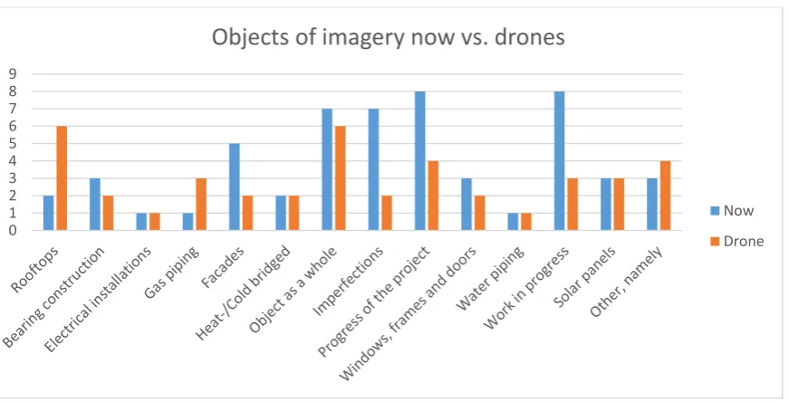
Figure 6: Objects of imagery now compared to with a drone
Respondents B and C from company L, an asbestos removal and rooftop renovator, expect a drone to scan a roof and export an exact 3D model where precise measuring can be done. The survey points out the potential users expect drones to be able to shoot imagery from rooftops and the objects as a whole. Respondent D also mentioned drones could be able to use a laser to project construction plans on site to indicate the locations of various entities. Thermal imagery shot with the help of drones was mentioned but was not as interesting to the respondents as monitoring the progress of the project or taking promotional imagery.
An alternative use of drones in a construction project is given by one respondent of the survey, mentioning drones could be used to scare off nesting birds from a construction site. This option was not found earlier but this could be useful to the industry.
6.2.
Expected advantages/disadvantages of drones
The advantages and disadvantages according to the potential users are given in this section. The attributes of Rogers (1983) are applied again.
Relative advantage
Respondents B and C said they think using a drone would save them a lot of time in their work because the drone could be used to measure a roof in a short amount of time (this is confirmed by respondent A of company K, a professional drone producer). The drone takes 10 minutes to start up, the flight itself would take about 5 minutes. Including the creation of a flight plan and export to measurable 3D model, the whole project would take about an hour of time on location. Instead of someone who needs to go up the roof, estimating measurements and come back a second time for the exact measurements. Using a drone also gives safety advantages according to respondents B and C.
Drones also come with some disadvantages. In the survey the issue of violation of privacy was mentioned twice as a disadvantage. But also the fear of drones crashing and harming persons or materials was given by respondent E, this was also mentioned by one of the respondents of the survey. Further, regulations were mentioned three times in the survey and in all of the interviews to be a limiting factor to the usage of drones.
0 1 2 3 4 5 6 7 8 9
Objects of imagery now vs. drones
Compatibility
To assess the compatibility of drones it is necessary to know the existing values, past experience and needs of potential users. A disadvantage for the use of drones is the existing value regarding privacy, as mentioned above. Imagery in a construction project gained in popularity over the past 20 years from nearly nothing to polaroids to mobile devices such as smartphones and tablets (respondents D and E). Imagery captured using a drone would be the next step forwards. There is not a lot of experience with drones during construction projects, but companies M and N have used drones before in order to obtain promotional images and videos of projects. The imagery gives new angles that have good promotional values. The needs of the potential user depends on the application the user wants. The applications are described in section 6.1.
Complexity
Company K produces professional drones, they can deliver a special ‘waypoint’ package that enables the user to program a pre-determined flight path using Google maps so the drone will operate autonomously. This of course makes the drone quite easy to use. But flying the drone manually is always required as a backup, this takes some time to learn and theoretical and practical exams are required. In order to obtain goo quality imagery with a drone there should be an operator for the drone itself and one for the camera. This was mentioned as a disadvantage by respondent E, two fte’s.
Trialability
The interview of company L was combined with a meeting with company K (a drone producer) because company L wanted to assess the possibilities that a drone could offer for their work. Company L definitely wanted to try using a drone, but the information given by respondent A regarding the price and regulations were discouraging. The price of the drone was quite high for a trial. Further, the regulations regarding professional usage of drones are strict and costly as well. For company B the prohibition of drone in the urban environment was not a big problem. But as mentioned three times by the respondents of the survey and respondents D and E this definitely is a disadvantage for using drones. One of the respondents of the survey also pointed out that drones “are not common good in the construction industry yet” which discourages potential users to use drones.
Observability
Drones are quite a phenomenon. Because it is so innovative in the construction industry, respondents B and C from company L believe adopting a drone in their company will give them positive marketing value. A disadvantage of the visibility of a drone can be that workers get distracted by the drone flying around the construction site. This could have a negative effect on the efficiency of the workers, but it could also create unsafe situations as was stated by respondent D.
6.3.
Valuation of drones
work, a cost reduction of €8,800 a year would make the drone break even. This seems to be an easy task given the time a drone could spare a company. Yet still it seems people are too afraid to take the step towards the usage of drones.
6.4.
Preliminary conclusions
The expected applications found by the empirical data were divided between what the respondents use imagery for and what they thought a drone could do for them.
Information regarding imagery can be summed up as:
Imagery is shot preferably with a smartphone (9/12 respondents of the survey);
In cooperation with the smartphone contractors use tablets with special construction management software on them that use imagery as input (respondents D and E of the interviews);
Imagery is used for quality control, project progress monitoring and promotional purposes;
Infrared imagery is not often used according to respondent B and the survey (0-20% of the projects), respondents D and E did mention to use thermography in almost every project.
Application of drones the respondents gave:
Inspection of hard to reach areas (all of the interviews and mentioned in the survey);
Scanning to 3D export where measurements can me made (respondents A, B and C);
Projecting drawings and measurements using a laser.
7.
Analysis
In this chapter the results of the survey and interviews will be compared to the outcome of the literature study.
7.1.
Applications of drones
From the literature it was found drones could be used for:
Visual inspections in hard to reach places in order to save time, increase safety and reduce costs because of regulations for working at height (Euronorm, 2015);
Thermographic imagery to detect construction integrity (Balaras & Argiriou, 2002);
Insulation flaws (Balaras & Argiriou, 2002);
Weak spots in concrete (Balaras & Argiriou, 2002);
Flaws in electrical of mechanical installations (Balaras & Argiriou, 2002);
Check photovoltaic cells (Pilla, Galmiche & Maldague, 2002);
Check if maximum amount of built surface is not exceeded (Fornace, Drakeley, William, Espino & Cox, 2014);
Identifying the location of materials on the construction site in real-time with the use of a special software layer (Bieda, Jaskot, Jędrasiak & Nawrat, 2013 & Niethammer, James, Rothmund, Travelletti & Joswig, 2012);
Using a drone as a transportation device (West, 2015).
The empirical data gives the following expected applications for drones according to the potential users:
Shooting imagery for marketing purposes (8/12 respondents of the survey and respondents D and E in the interviews);
Infrared images for BREEAM certification (1 respondent in the survey and respondents D and E in the interviews);
Inspection of rooftops (6/11 respondents in the survey and respondents A, B, C, D and E in the interviews);
Monitoring the work in progress (3/11 respondents in the survey and respondents C and D in the interviews);
Shooting images at hard to reach places and of the object as a whole (6/11 respondents of the survey and respondents C and D in the interviews);
Making 3D models that include measurements (respondents A, B and C in the meeting and interview);
Aiding the contractor to monitor the construction site (respondents D and E in the interviews);
Projecting measurements and construction plans for the workers (respondent D in the interview);
Transporting materials and tools to and from the worker (respondent D and E in the interviews);
Scaring of nesting birds from a construction site (1 respondent of the survey).
When comparing these results it can be found that both the information from the literature and the empirical data from the survey and interviews point out that drones can be used to conduct inspections at locations that are hard to reach (especially locations at height).
found in the literature are not known by the potential users. For example, checking photovoltaic cells with the help of an infrared-drone.
Further there is a gap between what the potential users want with a drone, but which has not been found in the literature. This means the potential user does not have a good overview of the possibilities a drone has to offer. For example, the potential user expects that it is possible to project measurements on the construction site with the help of a drone. But there were no cases of such an application found in literature.
7.2.
Advantages/disadvantages
In this section, the results of the advantages and disadvantages found in the research will be compared. A summary of the results of section 4.2 and section 6.2 in perspective to the attributes of Rogers (1983) is given in Table 3.
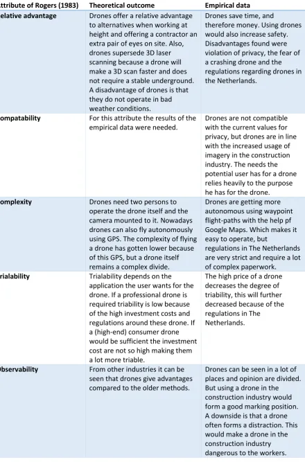
From Table 3 it can be concluded that for the attribute ‘relative advantage’ the theoretical outcome and the empirical data gathered do not match. The theoretical outcome was mostly focused on the technical abilities and not so much on economic and social aspects. The potential users were focussed a lot more to the economic and social aspects. This can indicate to a lack of knowledge of the potential users to the technical abilities a drone has to offer.
The degree of compatibility is low, this was shown in section 7.1 because it is found that there is a mismatch between what the potential user believes the drone can do and what a drone could do according to the literature study.
For the potential users of drones knowledge about the legal issues and regulations need to be clarified, because this is a very complex issue for them. The legal issues surrounding drones were not elaborated in the literature study because it was out of the scope of the research. The complexity of flying a drone had gotten better because of the ability to fly using a pre-determined flight-path. This was found in both the literature study and the empirical data.
The trialability of drone technology in the construction industry was found to be is very low because of the high investment costs in both the empirical data and the literature study. Further, the potential users are also demotivated to try using a drone because of the regulations in the Netherlands which was found as a disadvantage in the literature study as well.
Table 3: Analysis of the advantages/disadvantages in the perspective of Rogers’ (1983) attributes.
Attribute of Rogers (1983) Theoretical outcome Empirical data Relative advantage Drones offer a relative advantage
to alternatives when working at height and offering a contractor an extra pair of eyes on site. Also, drones supersede 3D laser scanning because a drone will make a 3D scan faster and does not require a stable underground. A disadvantage of drones is that they do not operate in bad weather conditions.
Drones save time, and
therefore money. Using drones would also increase safety. Disadvantages found were violation of privacy, the fear of a crashing drone and the regulations regarding drones in the Netherlands.
Compatability For this attribute the results of the empirical data were needed.
Drones are not compatible with the current values for privacy, but drones are in line with the increased usage of imagery in the construction industry. The needs the potential user has for a drone relies heavily to the purpose he has for the drone.
Complexity Drones need two persons to operate the drone itself and the camera mounted to it. Nowadays drones can also fly autonomously using GPS. The complexity of flying a drone has gotten lower because of this GPS, but a drone itself remains a complex divide.
Drones are getting more autonomous using waypoint flight-paths with the help pf Google Maps. Which makes it easy to operate, but
regulations in The Netherlands are very strict and require a lot of complex paperwork.
Trialability Trialability depends on the application the user wants for the drone. If a professional drone is required triability is low because of the high investment costs and regulations around these drone. If a (high-end) consumer drone would be sufficient the investment cost are not so high making them a lot more triable.
The high price of a drone decreases the degree of triability, this will further decreased because of the regulations in The
Netherlands.
Observability From other industries it can be seen that drones give advantages compared to the older methods.
8.
Discussion
This chapter will contain the discussion regarding the research results.
Results of the research
The results found in the literature study were not always very conclusive. Information found was about the subject, but in another industry or setting. This is because the combination of drones in the construction industry is new and there is no real research conducted about this specifically.
The surveys response rate was very low, regardless of the attempts of the researcher to spread the survey. The link on LinkedIn page of the supervisor is believed to be a turning point for the survey. Before this link was posted, in a feedback moment with the supervisor, it was decided to start with interviews to support the survey for gathering empirical data for the research.
It was intended to record every interview, however, the meeting between company A and company B was in a noisy hotel restaurant. That made recording the meeting and interview afterwards impossible. The interview was also not fully conducted as was intended, but this was because a lot of the questions that were going to be asked in the interview were already answered in the meeting between the companies A & B.