www.earth-syst-sci-data.net/6/1/2014/ doi:10.5194/essd-6-1-2014
©Author(s) 2014. CC Attribution 3.0 License. Open
Access
Science
Data
A spatial database of wildfires in the United States,
1992–2011
K. C. Short
USDA Forest Service, Rocky Mountain Research Station, Missoula Fire Sciences Laboratory, 5775 US Hwy 10 W, Missoula, Montana, 59808, USA
Correspondence to: K. C. Short ([email protected])
Received: 13 June 2013 – Published in Earth Syst. Sci. Data Discuss.: 3 July 2013 Revised: 7 December 2013 – Accepted: 10 December 2013 – Published: 3 January 2014
Abstract. The statistical analysis of wildfire activity is a critical component of national wildfire planning, operations, and research in the United States (US). However, there are multiple federal, state, and local enti-ties with wildfire protection and reporting responsibilienti-ties in the US, and no single, unified system of wildfire record keeping exists. To conduct even the most rudimentary interagency analyses of wildfire numbers and area burned from the authoritative systems of record, one must harvest records from dozens of disparate databases with inconsistent information content. The onus is then on the user to check for and purge redundant records of the same fire (i.e., multijurisdictional incidents with responses reported by several agencies or departments) after pooling data from different sources. Here we describe our efforts to acquire, standardize, error-check, compile, scrub, and evaluate the completeness of US federal, state, and local wildfire records from 1992–2011 for the national, interagency Fire Program Analysis (FPA) application. The resulting FPA Fire-Occurrence Database (FPA FOD) includes nearly 1.6 million records from the 20 yr period, with values for at least the fol-lowing core data elements: location, at least as precise as a Public Land Survey System section (2.6 km2grid),
discovery date, and final fire size. The FPA FOD is publicly available from the Research Data Archive of the
US Department of Agriculture, Forest Service (doi:10.2737/RDS-2013-0009). While necessarily incomplete
in some aspects, the database is intended to facilitate fairly high-resolution geospatial analysis of US wildfire activity over the past two decades, based on available information from the authoritative systems of record.
1 Introduction
The statistical analysis of wildfire activity has long been a critical component of national wildfire planning, operations, and research in the United States (US) (Show and Kotok, 1923; Brown, 1959; Hardy and Hardy, 2007). The analy-sis of historical fire and weather records, for example, is currently integral to national fire danger rating applications (Andrews and Bradshaw, 1997; Bradshaw and McCormick, 2000; Andrews et al., 2007), fire-potential forecast models (Andrews et al., 2007), and several widely used geospatial fire modeling systems (Stratton, 2006; e.g., Sanborn, 2009; Ager et al., 2010; Finney et al., 2011). These operational sys-tems are relied upon to generate consistent national data for risk assessment, planning, budget formulation, and decision support at multiple scales (Buckley et al., 2006; Hardy and
US wildfire activity statistics have been reported in various forms since the early 20th century. State- and national-level estimates of wildfire numbers and area burned, for example, are available for circa 1912 to 1997 in US Department of Agriculture, Forest Service (USFS) wildfire statistics publi-cations (e.g., USFS, 1998a) and from circa 1999 to present from the Predictive Services Intelligence Section at the Na-tional Interagency Coordination Center (e.g., NICC, 2012b). The USFS wildfire statistics, often referred to as “Smokey Bear Reports”, summarize wildfire activity by US state and therefore lend themselves only to analyses at the level of the state or interstate region. The NICC statistics, published in Wildland Fire Summary and Statistics Annual Reports, are based on calendar-year summaries of wildfire activity from the interagency Situation Report/209 (SIT/209) application (USFS, 2009). The Situation Report (SIT) module of the SIT/209 application keeps a running tally of wildfires and area burned by agency unit (including participating federal, state, local, and private entities) based on daily activity re-ports from dispatch offices during fire season and weekly re-ports otherwise (NIFC, 2011; NICC, 2012a). Detailed infor-mation regarding individual large fires and other significant incidents is entered separately into the Incident Command
System – 209 (ICS-209) module of the SIT/209 application,
generally by local dispatch personnel or by the team man-aging the incident (NIFC, 2011; NICC, 2012a). In sum, the ICS-209 provides detailed, incident-specific information, but only for significant events (e.g., large fires), while the SIT provides daily and cumulative (year-to-date) total fire counts and area-burned estimates for all fires reported by dispatch offices, summarized by agency unit. The SIT/209 system was designed for tactical support (e.g., to help determine firefight-ing priorities and resource needs), and while its estimates of wildfire numbers and area burned may be the best available at the time of need (i.e., to characterize the current “situ-ation”), they are not necessarily complete or accurate and thus should be considered initial figures only (NFAEB, 2007; NIFC, 2011). Internal inconsistencies (i.e., in the SIT ver-sus ICS-209 modules) and inconsistencies with other data sources (e.g., agency fire reports, described below) are not necessarily reconciled before the final NICC annual wildfire activity statistics are published (C. Leonard, personal com-munication, 2011). Despite their potential weaknesses, the published NICC numbers have commonly been used to char-acterize national, regional, and subregional (e.g., state) wild-fire activity levels in recent decades (e.g., Andrews, 2005; Hammer et al., 2009; Urbanski et al., 2009; Kolden and Brown, 2010; Reid et al., 2010; Thomas and Butry, 2012).
Incident-level wildfire reporting also occurs within each of the five major US federal agencies with wildland-fire-management programs, as they are required to complete In-dividual Fire Reports for all fires under federal protection or on federal ownership and to enter that information into their respective systems of record. These “final fire reports” are intended to be the authoritative sources of wildland fire
ac-tivity statistics for the federal agencies. The USFS uses the FIRESTAT application (USFS, 2003) to transmit and archive data entered from the FS-5100-29 Individual Fire Report form (Donoghue, 1982a; USFS, 2000) into the National In-teragency Fire Management Integrated Database (NIFMID) (USFS, 1998b; Bunton, 2000). The USFS fire reports in NIFMID, which is accessible via the national Fire and Avi-ation Management Web ApplicAvi-ations site (FAMWEB, https:
//fam.nwcg.gov/fam-web/), currently date back to 1970. The four major US Department of the Interior (USDI) agencies with wildland fire programs all use the DI-1202 Individual
Fire Report form, but the Bureau of Indian Affairs (BIA),
Bureau of Land Management (BLM), and National Park Ser-vice (NPS) enter and store the information in the Wildland Fire Management Information (WFMI) system, while the US Fish and Wildlife Service (FWS) archives its data us-ing a separate application, the Fire Management Informa-tion System (FMIS). The USDI fire reports date back to the 1960s. Most state and some local entities have independent reporting systems of their own, with records for various peri-ods. The states of California and Oregon, for example, main-tain publicly accessible incident-level databases that are dis-tinct from each other and the federal systems. In addition, there are currently two national non-federal reporting sys-tems, which are used increasingly either in concert with, or in lieu of, a state-maintained system. The National Associ-ation of State Foresters (NASF) database is intended to be a clearinghouse of state-fire-service wildfire records, acces-sible via the FAMWEB data warehouse, while the National Fire Incident Reporting System (NFIRS) of the US Fire Ad-ministration (USFA) is intended to capture incident informa-tion, including wildfire data, from US fire departments (i.e., city, district, county), as overseen by state fire marshal offices (Hall and Harwood, 1989; Thomas and Butry, 2012). Al-though NFIRS is administered by a federal agency (USFA), we refer to it as a non-federal system, because it includes fire reports from local departments rather than from federal agen-cies. (Abbreviations, acronyms, and aliases used repeatedly throughout this paper are defined in Appendix A.)
intending to analyze wildfire occurrence to check for and purge redundant records of the same fire after pooling data from different sources. The redundant records will tend to be of multijurisdictional incidents (e.g., automatic aid incidents, large fires impacting multiple ownerships) with responses re-ported by several firefighting entities (see Bunton, 1999; Art-ley, 2009).
The problems with data compilation from the multiple wildfire systems of record affect far more than FFP users, however, and there have been repeated calls for a single fioccurrence database to support national operations and re-search. In 1995, the Federal Wildland Fire Policy recognized that “accurate, organized, and accessible information about natural/cultural resources and fire activities is the basis for coordinated agency program decisions and is crucial to
ef-fective and efficient program management” and called for
federal agencies to “standardize fire statistics and develop an easily accessible common database” (USDI and USDA, 1995). The necessary business analysis subsequently was performed with oversight from the National Wildfire Co-ordinating Group (NWCG). The resulting National Intera-gency Fire Statistics Information Project (NIFSIP) delivered business-process and conceptual data models for an intera-gency fire-reporting system that could be coordinated with non-federal cooperators and allow upward reporting of fed-eral information to NFIRS (USFS, 1998c; Bunton, 1999), but no system was actually developed. The need for one per-sisted, however, and the 2001 update to the 1995 Federal Wildland Fire Policy again included a call for development of “coordinated databases for federal fire information that sup-port fire program development and [policy] implementation” (USDI et al., 2001). By that time, however, it was becoming increasingly clear just how daunting that task would be, es-pecially if non-federal data integration was to remain part of the ultimate goal.
Not long after the 2001 fire policy update was released, reports from three notable and independent efforts to com-pile wildland fire occurrence data from the various systems of record were published. In 2002, Westerling et al. (2003) compiled more than 400 000 wildland fire records spanning 20–30 yr from the USFS, BLM, BIA, and NPS for west-ern US fire-climate analyses. Due to “data quality [sic] con-cerns”, BLM reports of fires that occurred prior to 1980 were excluded from the research data set, which subsequently contained approximately 300 000 fire records from western federal lands for the period 1980–2000. The climatologi-cal analyses of Westerling et al. (2003) hinged on having fire location information more specific than state, county, or agency unit. They explained that the quality of the location data for some of the records, particularly the “older” subset, “constrains a comprehensive, regional-scale analysis to a 1-degree [approximately 111 km] grid resolution.” Westerling et al. (2003) did not indicate whether further quality-control measures were taken to remove redundant records from the resulting gridded data set of fires and area burned.
Brown et al. (2002) reported to the NWCG specifically re-garding the completeness and quality of the fire data from the US federal systems of record. They evaluated all agency fire-report data from 1970–2000 but, like Westerling et al. (2003), considered the USDI fire-occurrence data to “effectively start in 1980” due to “very minimal” reporting prior. Brown et al. (2002) deemed fire records “usable” if they included apparently accurate (or correctable) values for the follow-ing data elements: (1) discovery date, (2) location (lati-tude/longitude), (3) total area burned, and (4) cause. Loca-tions that could be converted to latitude/longitude from a
Public Land Survey System (PLSS) section (2.6 km2 grid)
identifier were considered viable. Their quality-control ef-forts included checking for duplicate records (both intra-agency and interintra-agency). A duplicate, or identical, record was defined by Brown et al. (2002) as having “exactly the same values for all fields” as another record in the data set. Of the 657 949 federal fire records evaluated, only 538 809 could be flagged as usable and non-redundant per their crite-ria. While their work was invaluable in pointing out problems related to the completeness, quality, and consistency of core elements of wildfire data in the federal systems of record, Brown et al. (2002) considered the data set of Schmidt et al. (2002), which focused on a shorter period of record, to be the only “quality controlled [sic] historical observed individ-ual federal fire occurrence set” available at the time.
The work of Schmidt et al. (2002) was particularly
re-markable because it included efforts to compile core data
Building on the initial efforts of the NIFSIP and in-formed to some degree by the work of Brown et al. (2002) and Schmidt et al. (2002), progress toward a national fire-reporting system ostensibly has been made over the last decade (see NWCG, 2003; NFAEB, 2007). Still, no such sys-tem exists. In 2003, a prototype for the national Fire Program Analysis (FPA) system was initiated, and it was recognized that several components of that system would rely on histor-ical wildfire activity data from both federal and non-federal systems of record. FPA is a national, interagency applica-tion intended to evaluate the effectiveness of alternative fire-management strategies and thereby support national planning activities and budget development (see Mavsar et al., 2013). FPA requires wildfire activity data as inputs to, and for eval-uation of output from, its Initial Response Simulator (see Fried and Fried, 2010) and Large Fire Module (see Finney et al., 2011). For these purposes, the wildfire records must include, at minimum (1) location, at least as precise as PLSS section, (2) discovery date, and (3) final fire size. Some ad-ditional elements such as fire name, cause, and containment date are sought but not required for a record to be consid-ered “viable”. Interagency guidance to FPA was to exclude fire records older than 1992 from consideration due to con-cerns about both the quality and the completeness of the data (J. Fotjik, personal communication, 2012).
FPA was released in 2008, and the first national analy-sis was completed in 2009 (USDI, 2009). At that time the system drew upon a wildfire data set spanning 1992–2008 that included records from the federal systems of record as well as the NASF database and NFIRS. The data were com-piled and quality-checked in a manner that expanded upon the approaches used by Brown et al. (2002) and Schmidt et al. (2002). The original process, documented in an un-published technical guide (FPA, 2010), was adapted in 2010 to include additional non-federal data from state-maintained systems of record and to more thoroughly screen the com-piled data set for redundant records. Data for 2009–2010 were added during the winter of 2011. Data for 2011 and pre-viously absent records from prior years were acquired from the NASF database via FAMWEB and added during the win-ter of 2012. The resulting national spatial database of US wildfires 1992–2011, referred to as the FPA Fire-Occurrence Database (FPA FOD), is presented and described here. Only the subset of basic elements used by FPA is included, but additional attributes can be drawn from the source systems using the identifier of the original record, which is retained in the FPA FOD. Record identifiers from the ICS-209 ap-plication and the satellite-derived Monitoring Trends in Burn Severity (MTBS) national fire-perimeter data set (Eidenshink et al., 2007) are also included for a subset of the fires, pro-viding, in essence, bridges to those information systems. We evaluate the completeness of the resulting data set by com-paring estimates of wildfire numbers and area burned from the FPA FOD with published wildfire activity statistics by state and year.
2 Methods
2.1 Data sources
Wildfire records for the period 1992–2011 were acquired from federal, non-federal, and interagency systems of record (Table 1). Records were required to have values for the fol-lowing attributes to be considered candidates for inclusion in the FPA FOD: (1) location at least as precise as PLSS section, (2) discovery date, and (3) final fire size. Candi-date non-federal records were available from the two na-tional, non-federal reporting systems (NASF, NFIRS) only for a subset of states and years, largely due to limited state and local participation and a lack of sufficient loca-tion informaloca-tion in submitted fire reports. Addiloca-tional candi-date non-federal data were acquired from state-maintained and interagency systems to augment the subset drawn from
NASF and NFIRS. FPA staff associated with the Alabama
Forestry Commission (AFC) provided AFC data for 2003– 2009, and the Texas A&M Forest Service (TFS) provided a compiled data set of state and local wildfires reported to the TFS since 2005. Due to time constraints, data were not sought directly from all other US states and territories. In-stead, we drew non-federal wildfire data that were readily available online and capitalized on past and present efforts to compile non-federal fire records, obtaining multi-state data sets from the other projects. Publicly available wildfire data were downloaded from the Alaska Interagency Coor-dination Center (http://fire.ak.blm.gov/), the Oregon Depart-ment of Forestry (http://www.oregon.gov/ODF/GIS/gisdata.
shtml), the Virginia Department of Forestry (http://www.
dof.virginia.gov/gis/dwnload/index.htm), and the
Wiscon-sin Department of Natural Resources (ftp://gomapout.dnr.
state.wi.us/geodata/forestry/fire_occurrence.zip). Data from the California Department of Forestry and Fire
Protec-tion were downloaded from FAMWEB (http://fam.nwcg.
gov/fam-web/weatherfirecd/fire_files.htm). Multi-state non-federal data sets for at least part of the period of interest were obtained from Schmidt et al. (2002), the Southern Wild-fire Risk Assessment (SWRA; see Buckley et al., 2006), the MTBS project, and the USFS Eastern Forest Environmental Threat Assessment Center (EFETAC) (Table 1).
2.2 Data processing and quality control
Table 1.Sources of wildfire data in the FPA FOD. Although the National Fire Incident Reporting System is administered by a federal agency (USFA), we refer to it as a non-federal system, because it includes fire reports from local departments rather than from federal agencies. We distinguish the Alaska Interagency Coordination Center and ICS-209 as interagency systems, because they are sources of federal, state, and local reports.
Category Source FOD Acronym
Federal USDI Wildland Fire Management Information System DOI-WFMI FWS Fire Management Information System FWS-FMIS
USFS Fire Statistics FS-FIRESTAT
Non-federal USFA National Fire Incident Reporting System FA-NFIRS National Association of State Foresters ST-NASF Alabama Forestry Commission (AFC)a,b ST-ALALS Arkansas Forestry Commissiona,c ST-ARARS
Arizona State Forestry Divisiond ST-AZAZS
California Department of Forestry and Fire Protection ST-CACDF
Colorado State Forest Servicee ST-COCOS
Connecticut Division of Forestryf ST-CTCTS
Florida Forest Serviceg ST-FLFLS
Georgia Forestry Commissionh ST-GAGAS
Kentucky Division of Forestryi ST-KYKYS
Louisiana Office of Forestryj ST-LALAS
Maine Forest Servicek ST-MEMES
Michigan Department of Natural Resourcesd,l ST-MIMIS Missouri Department of Conservationm ST-MOMOS Mississippi Forestry Commissionn,o ST-MSMSS Montana Department of Natural Resources & Conservationn ST-MTMTS North Carolina Division of Forest Resourcesp ST-NCNCS
Nebraska Department of Forestryq ST-NENES
New Mexico State Forestryn ST-NMNMS
Oklahoma Division of Forestrya,d ST-OKOKS
Oregon Department of Forestry ST-ORORS
South Carolina Forestry Commissiona,r ST-SCSCS South Dakota Wildland Fire Suppression Divisions ST-SDSDS Tennessee Division of Forestrya,t ST-TNTNS Texas A&M Forest Service (TFS)u ST-TXTXS Utah Division of Forestry, Fire & State Landsv ST-UTUTS Virginia Department of Forestry (VDOF)w ST-VAVAS
Washington State Headquartersx ST-WAWAS
Wisconsin Department of Natural Resources (WIDNR)y ST-WIWIS
Wyoming State Forestry Divisiond ST-WYWYS
Interagency Alaska Interagency Coordination Centerz IA-AKACC ICS-209 module of the SIT/209 application IA-ICS209
aData for 1997–2002; acquired from the Southern Wildfire Risk Assessment effort (SWRA).bData for 1994–1996; acquired
from MTBS. Data for 2003–2009; acquired directly from AFC. Data for 2010 acquired from the Eastern Forest
Environmental Threat Assessment Center (EFETAC).cData for 2009–2010; acquired from EFETAC.dData for 1992–1996;
acquired from Schmidt et al. (2002).eData for 1992–1995; acquired from MTBS.fData for 1992–2009; acquired from
EFETAC.gData for 1992–2002; acquired from SWRA.hData for 1992–1997; acquired from EFETAC. Data for 1998–1999;
acquired from SWRA. Records of fires located south of latitude 31.05 were missing from the 1998 SWRA data set and acquired from EFETAC.iData for 1997–2001; acquired from SWRA.jData for 1997–2002; acquired from SWRA. Data for
2009–2010; acquired from EFETAC.kData for 1992–1993; acquired from Schmidt et al. (2002). Data for 1994–2002, 2004;
acquired from MTBS.lData for 1998–1999 (large fires only); acquired from MTBS.mData for 1992–1997; acquired from
Schmidt et al. (2002). Data for 1998–2002; acquired from MTBS.nData for 1992–1999; acquired from MTBS.oData for
2000–2007; acquired from SWRA.pData for 1992–2004; acquired from SWRA. Data for 2010; acquired from EFETAC. qData for 1994–1999 (large fires only); acquired from MTBS.rData for 1992–1996; acquired from MTBS.sData for
1992–2002; acquired from MTBS.tData for 2005; acquired from MTBS.uData for 2009–2011; acquired directly from TFS. vData for 1992–2003; acquired, from MTBS,wData for 1995–1996, 2003 acquired directly from VDOF. Data for
1997–2002; acquired from SWRA.xData for 1992–2004; acquired from MTBS.yData for 1992–1996; acquired from
Schmidt et al. (2002). Data for 1997–2002; acquired directly from WIDNR.zData for 1992–1995 and 2008–2010; acquired
2.2.1 Standardization
Data were not formatted consistently across the various systems of record, and the following transformations, in-tended to comply as best as possible with NWCG data standards (http://www.nwcg.gov/pms/stds/standards/), were made when necessary. Of course, our ability to conform the data (see Table 2) to NWCG standards was constrained by the level of adherence to those standards within the source reporting systems throughout the period of record.
After making any necessary geographic transformations, locations were formatted as latitude and negative longitude in decimal degrees, based on the North American Datum 1983. Precision to eight decimal places was retained, when avail-able, for the sake of consistency with the source informa-tion. However, both the accuracy and precision of the loca-tion estimates are generally much lower than that implied by the stored coordinate information – which, for example, may have been calculated from a PLSS section centroid. Dates
were formatted as mm/dd/yyyy, and time as hhmm (using
the 24 h clock). Final fire size was formatted to indicate area
in acres (1 acre=0.405 hectare), which is the NWCG
stan-dard. The full precision of the estimate in the fire report was retained, which may or may not meet the NWCG stan-dard of tenth-acre precision for all fires less than one acre. If the source database did not include a code or number that uniquely identified each record, we created one by ei-ther concatenating data elements or simply auto-numbering the records. We cross-walked the reporting agency and unit to the active NWCG Unit Identifier standard (see NWCG, 2012b), and we include the active Unit Identifier data set that we downloaded from https://www.nifc.blm.gov/unit_id/ Publish.html on 5 March 2012 and used for our cross-walk as a lookup table, NWCG_UnitIdActive_20120305, in the fi-nal database. We removed any extraneous leading and trail-ing characters from the FireCode (https://www.firecode.gov/ index.cfm?action=login), which is a standardized four-digit federal accounting code assigned to fires and included in most federal fire reports that date back to circa 2003, pro-viding a link to the agencies’ financial systems (USDI and USDA, 2013). Fire names were converted to uppercase, but otherwise unadjusted. Some fire names had clearly been trun-cated, for example, by the source system or by some data en-try or transfer process, but we made no attempt to “correct” or harmonize them. The NWCG data standard for fire cause is currently pending, so we cross-walked the cause descrip-tions from the various systems of record to a set of codes and names (Table 3) based on those used by the USFS for sta-tistical analysis (USFS, 2003). Values indicating landowner at the fire’s location (i.e., owner at origin) were cross-walked to a set of names and codes (Table 4) based on the NWCG standard landowner categories (http://www.nwcg.gov/pms/ stds/standards/land-owner-kind-category_v1-0.htm). While based on existing conventions, the full suite of cause and owner codes and values to which we cross-walked (Tables 3
Table 2.Data elements extracted from wildfire reports and used to populate the FPA FOD.
Item Description
Location∗ Point of origin of the fire, at least as
precise as PLSS Section.
Discovery Date∗ The date that the fire was discovered or
confirmed to exist.
Final Fire Size∗ Area within the final perimeter of the
fire.
Record Identifier Code or number that uniquely
iden-tifies the record within the source database.
Reporting Agency Identifier for the reporting agency.
Reporting Unit Identifier for the reporting unit within
the agency.
Local Fire Report ID Number or code that uniquely
identi-fies a fire report for a particular unit and a particular calendar year.
Local Incident ID Number or code that uniquely
identi-fies an incident for a particular local fire-management organization within a particular calendar year.
FireCode Code used within the interagency
wild-land fire community to track and com-pile cost information for emergency fire suppression expenditures.
Fire Name The name of the incident.
Discovery Time Time of day that the fire was
discov-ered or confirmed to exist.
Fire Cause The reported cause of the fire.
Contain Date Date on which the fire was declared
contained.
Contain Time Time of day that the fire was declared
contained.
Owner Name of primary owner or entity
re-sponsible for managing the land at the point of origin of the fire at the time of the incident.
State Name of the state in which the fire is
reported to have burned (or originated).
County County in which the fire is reported to
have burned (or originated).
Fire Type Type of fire, in terms of management
response.
Protection Type Entity responsible for fire protection at
the point of origin.
Table 3. Fire cause codes and definitions, adapted from USFS (2003).
Code Definition
1 Lightning 2 Equipment Use 3 Smoking 4 Campfire 5 Debris Burning 6 Railroad 7 Arson 8 Children 9 Miscellaneous 10 Fireworks 11 Power line 12 Structure
13 Missing/Undefined
Table 4.Owner codes and definitions.
Code Definition
0 Foreign
1 BLM
2 BIA
3 NPS
4 FWS
5 USFS 6 Other Federal 7 State 8 Private 9 Tribal 10 BOR∗
11 County 12 Municipal/Local 13 State or Private 14 Missing/Undefined 15 Undefined Federal
∗USDI Bureau of Reclamation.
and 4) include categories that we added in order to more fully accommodate the range of information in the origi-nal records. The US state (or territory) in which the fire occurred was not nominally designated in all fire reports. In those cases, we populated that field with the name of the state to which the reporting unit is tied, so that we ob-tained a nominal locality designation for all records to use for quality-control purposes (i.e., to compare with the point locations; see Sect. 2.2.2). State names were converted to standard two-letter alphabetic Federal Information Process-ing Standards (FIPS) codes (NIST, 1987). County (or equiva-lent) names were cross-walked to the three-digit FIPS county codes (NIST, 1990). Allowable fire types, in terms of man-agement strategy, were coded as follows: 1 – actionable (i.e., suppression or appropriate management response taken), 2 – natural out, and 4 – fuels management (unplanned ignitions
Table 5. Protection type codes and definitions (adapted from WFMI).
Code Definition
1 Agency land protected by the agency
2 Agency land protected by another federal agency
3 Agency land protected by a non-federal agency
4 Less than full suppression response on agency lands
5 Non-agency land not under agreement, memorandum of understanding, or contract, where suppression ac-tion is taken by the agency to prevent fire spread to agency land (i.e., threat to agency)
6 Other (non-agency) land protected by the agency un-der a cooperative agreement, memorandum of unun-der- under-standing, interagency mutual aid agreement, or con-tract
9 Naturally ignited wildland fire for which the appro-priate fire-management response is based on objec-tives from an approved Fire Management Plan (FMP) (i.e., “fire used for resource benefit” or “wildland fire use” when fire type=4)
only). Planned ignitions (i.e., prescribed fires), except those that escaped and ultimately required suppression response, were intentionally excluded from the FPA FOD. Protection type, specified only in the federal fire reports, was coded as indicated in Table 5.
2.2.2 Error checking
that would be redundantly reported in another system) and were therefore excluded from the FPA FOD. Federal fires (fires from a federal system of record) flagged for the same reason were not summarily excluded, however, because some agency units span or have fire protection responsibility or cooperative agreements in more than one state (e.g., NPS Appalachian National Scenic Trail, BLM Miles City Field
Office) and some nominal state designations were based on
the state designation in the unit name, which may not reflect the true state location of the fire. The flagged subset of sus-pect federal fires was therefore visually inssus-pected and only records with obvious spatial errors (e.g., fires<40 hectares mapping several states away from the expected domain) were excluded from further processing. In some cases, fires did not map within the state expected from the fire report, but did map within the domain of the interstate reporting unit (e.g., fires reported from Dinosaur National Monument mapping in Colorado and Utah, across which the unit spans) or were re-sponded to under cooperative agreement or as a threat to the unit’s land. In other cases, fires mapped near enough to the proclaimed state or unit such that the mismatch was ostensi-bly due to imprecision of the reported location. We did find fires that were clearly mislocated because they mapped over water, but we retained them if they fell within the expected domain of state or FPU.
Clearly erroneous dates (e.g., 1/1/1901, 12/6/4320) were excluded when we set our date range to 1992–2011. We checked for and omitted containment dates and times that preceded the fire discovery dates and times.
To avoid confusion regarding the numbers 0 and 1, the FireCode system does not generate codes containing the characters “O” or “I” (USDI and USDA, 2013). However, we found codes in several hundred fire records with an O or I that had been changed from a 0 or 1 at some point in the reporting process. We changed the incorrect letters to the correct numbers in the FPA FOD so that we could fully leverage FIRE_CODE in our quality-control processes (see Sects. 2.2.4 and 2.2.5).
2.2.3 Data compilation and derivation of additional elements
All viable data extracted from each of the systems of
record were compiled in a Microsoft®Access 2010 database.
Records from each of the systems were appended into a sin-gle Fires table with the schema shown in Table 6. As data were appended, the FOD_ID was assigned with an auto-numbering function. Either the numeric FOD_ID or the al-phanumeric FPA_ID can be used as the table’s primary key, as each uniquely identifies records in the database. It is the FPA_ID, however, that contains the necessary information to link back to the original data set. It consists of the unique identifier acquired (or created by concatenating elements) from the source system, with leading characters added to
en-sure that it remained unique after being pooled with records from other systems.
The fields SOURCE_SYSTEM and SOURCE_SYSTEM _TYPE, provide the system information summarized in Ta-ble 1 for each record. While fire year is included as an attribute separate from discovery date in most source sys-tems, to ensure logical consistency it was populated in the Fires table directly from DISCOVERY_DATE, as was day of year (DOY) for discovery and containment dates. FIRE_SIZE_CLASS was derived from FIRE_SIZE using the proposed NWCG standard class breaks and codes (http:
//www.nwcg.gov/pms/stds/fire_size_class/values.pdf).
2.2.4 Removing redundant records
Once the data were consistently formatted and pooled to-gether, we used a multistep process to identify and purge redundant fire records. In addition to the potential for mul-tiple reports of the same fire to appear within and among the various systems of record (Bunton, 1999; Brown et al., 2002; Schmidt et al., 2002), there is also the potential for redun-dancy from the ways that fire complexes are handled in the reporting process.
It is a fairly straightforward database exercise to identify fire records that are “duplicates” sensu Brown et al. (2002), because they have identical values for location, discovery date, total area burned, and cause. However, due to incon-sistencies in data collection, formatting, and storage require-ments, as well as information errors, the reporting systems are rife with records that are redundant but by no means iden-tical, and there is no simple process to remove them before or after pooling the data.
Examples of redundant fire records extracted from the re-porting systems are provided in Table 7. The process of Brown et al. (2002) likely would have flagged cases 1 and 2 as intra-agency and interagency duplicates, respectively, but overlooked the others in Table 7, because their coordi-nates, discovery dates, and area burned values do not match exactly. Fire cause is often unreported, especially in the non-federal systems, or may differ among reports due to the in-formation or reporting options available at the time of filing (see Donoghue, 1982b); thus, we did not enlist this field to assist in identifying redundant records. Instead, we primar-ily leveraged latitude, longitude, discovery date, fire size, and, when available, fire name and FireCode. We ran a se-ries of database quese-ries, explained as follows: we began with the most basic checks for duplicate records and progressed through steps that, as we cast a widening net, required in-creasing visual inspection to ensure that records flagged for exclusion from the final data set by the queries were indeed redundant with others to be retained. All records with flags that persisted to the end of the process (i.e., through step 10 below) were ultimately purged from the database.
Table 6.FPA FOD Fires table schema.
Field Name Data Type Definition
FOD_ID∗ Number Global unique identifier.
FPA_ID∗ Text Unique identifier that contains information necessary to track back to the
original record in the source data set. Can be used as primary key in lieu of FOD_ID.
SOURCE_SYSTEM_TYPE∗ Text Type of source database or system from which the record was drawn
(federal, non-federal, or interagency).
SOURCE_SYSTEM∗ Text Name of or other identifier for source database or system from which the
record was drawn.
NWCG_REPORTING_AGENCY∗ Text Active NWCG Unit Identifier for the agency preparing the fire report.
NWCG_REPORTING_UNIT_ID∗ Text Active NWCG Unit Identifier for the unit preparing the fire report.
NWCG_REPORTING_UNIT_NAME∗ Text Active NWCG Unit Name for the unit preparing the fire report.
SOURCE_REPORTING_UNIT Text Code for the agency unit preparing the fire report, based on code/name
in the source data set.
SOURCE_REPORTING_UNIT_NAME Text Name of reporting agency unit preparing the fire report, based on
code/name in the source data set.
LOCAL_FIRE_REPORT_ID Text Number or code that uniquely identifies an incident report for a particular
reporting unit and a particular calendar year.
LOCAL_INCIDENT_ID Text Number or code that uniquely identifies an incident for a particular local
fire-management organization within a particular calendar year.
FIRE_CODE Text Code used within the interagency wildland fire community to track and
compile cost information for emergency fire-suppression expenditures.
FIRE_NAME Text The name of the incident, from the fire report (primary) or ICS-209 report
(secondary).
ICS_209_INCIDENT_NUMBER∗ Text Incident (event) identifier, from the ICS-209 report.
ICS_209_INCIDENT_NAME∗ Text The name of the incident, from the ICS-209 report.
MTBS_ID∗ Text Incident identifier, from the MTBS perimeter data set.
MTBS_FIRE_NAME∗ Text Name of the incident, from the MTBS perimeter data set.
COMPLEX_NAME∗ Text Name of the complex under which the fire was ultimately managed, when
discernible.
FIRE_YEAR∗ Number Calendar year in which the fire was discovered or confirmed to exist.
DISCOVERY_DATE Date/time Date on which the fire was discovered or confirmed to exist.
DISCOVERY_DOY∗ Number Day of year on which the fire was discovered or confirmed to exist.
DISCOVERY_TIME Text Time of day that the fire was discovered or confirmed to exist.
STAT_CAUSE_CODE∗ Number Code for the (statistical) cause of the fire.
STAT_CAUSE_DESCR∗ Text Description of the (statistical) cause of the fire.
CONTAIN_DATE Date/time Date on which the fire was declared contained.
CONTAIN_DOY∗ Number Day of year on which the fire was declared contained.
CONTAIN_TIME Text Time of day that the fire was declared contained.
FIRE_SIZE Number The estimate of acres within the final perimeter of the fire.
FIRE_SIZE_CLASS∗ Text Code for fire size based on the number of acres within the final fire
perimeter.
LATITUDE∗ Number Latitude (NAD83) for point location of the fire.
LONGITUDE∗ Number Longitude (NAD83) for point location of the fire.
OWNER_CODE∗ Number Code for primary owner or entity responsible for managing the land at
the point of origin of the fire at the time of the incident.
OWNER_DESCR∗ Text Name of primary owner or entity responsible for managing the land at
the point of origin of the fire at the time of the incident.
STATE Text Two-letter alphabetic code for the state in which the fire burned (or
orig-inated), based on the fire report.
COUNTY Text County, or equivalent, in which the fire burned (or originated), based on
the fire report.
FIPS_CODE∗ Text Three-digit code from the Federal Information Process Standards (FIPS)
publication 6-4 for representation of counties and equivalent entities.
FIPS_NAME∗ Text County name from the Federal Information Process Standards (FIPS)
publication 6-4 for representation of counties and equivalent entities.
Table 7.Example cases of redundant records from the fire-reporting systems and steps in FPA FOD processing during which the records were flagged and all but one were removed from the final database. Fire size, shown here in hectares, is reported in the FPA FOD in acres, per the NWCG standard.
Processing Case Source Reporting Reporting Latitude Longitude Discovery Fire Fire Fire Cause Step System Agency Unit Date Size Name Code Code 1 1 FS-FIRESTAT FS MSMNF 32.36166667 −89.6 3/9/2006 3.8 ST. JOHN B6VU 5
FS-FIRESTAT FS MSMNF 32.36166667 −89.6 3/9/2006 3.8 ST. JOHN B6VU 5 2 DOI-WFMI BIA AKAKA 64.6403 −150.4502 6/8/2002 104 307 GESKAKMINA 1 DOI-WFMI BLM AKASO 64.6403 −150.4502 6/8/2002 104 307 GESKAKMINA A283 1 2 3 FS-FIRESTAT FS MTBDF 45.735 −111.89666667 9/30/1996 850 ANTELOPE CREEK 2 ST-MTMTS ST/C&L MTCES 45.73798 −111.89964 9/30/1996 850 ANTELOPE CREEK 9 3 4 DOI-WFMI BIA NCECA 35.5344 −83.2764 4/27/2009 934 STONEY RIDGE EVP1 2 DOI-WFMI NPS TNGSP 35.5344 −83.2764 4/27/2009 934 STONY RIDGE EVP1 2 5 FA-NFIRS ST/C&L NDSFM 48.51 −100.06 4/8/2007 165 9 FA-NFIRS ST/C&L NDSFM 48.51 −100.06 4/8/2007 165 9 4 6 DOI-WFMI BLM AKASO 66.4833 −142.2 7/19/2005 95 864.1 SALMON FK B02M 1 FWS-FMIS FWS AKYFR 66.48333333 −142.2 7/19/2005 95 864.1 SALMON FORK B02M 1 ST-NASF ST/C&L AKUYD 66.483330004 −142.20000001 7/19/2005 95 864.1 1 7 FWS-FMIS FWS FLFPR 26.285 −81.54083333 5/19/1999 0.04 DOF387 4494 9 ST-FLFLS ST/C&L FLFLS 26.29 −81.54 5/19/1999 0.04 1 5 8 DOI-WFMI BIA CASCA 32.7834 −116.8342 9/26/1993 9 SYCUAN 5 FWS-FMIS FWS CATNR 32.78333333 −116.83333333 9/26/1993 4 SYCUAN 9 9 FWS-FMISFS-FIRESTAT FSFWS CACNFCATNR 32.9855555632.9988232 −−116.7275116.7229304 1010//2525//20032003 114 643113 423 CEDARCEDAR 22 6 10 FS-FIRESTAT FS MTCNF 45.65083333 −105.99666667 9/5/2002 4.7 LISCOM II 1 DOI-WFMI BLM MTMCD 45.7292 −105.995 9/6/2002 4.7 LISCOM II H077 1 7 11 FS-FIRESTAT FS ORRSF 42.03888889 −123.91166667 7/13/2002 202 478 BISCUIT 5833 1 ST-ORORS ST/C&L ORORS 42.405 −123.89233333 7/15/2002 202 478 ODF/BISCUIT 1 12 FS-FIRESTAT FS CASTF 37.90666667 −120.14333333 8/14/1996 8485 ROGGE 1 DOI-WFMI BLM CACND 37.8999 −120.1344 8/13/1996 8942 ROGGE 1 13 FS-FIRESTAT FS FLFNF 30.35833333 −82.48333333 3/3/2004 13 851 IMPASABLE 1 A0J4 5 ST-NASF ST/C&L FLFLS 30.404719991 −82.500000014 3/7/2004 14 037 5 14 DOI-WFMI BLM NMADO 34.9175 −107.9839 7/20/2000 840 WALL L271 1 DOI-WFMI NPS NMEMP 34.84778 −107.98287 7/22/2000 810 WALL 1 15 FS-FIRESTAT FS ORWIF 43.47416667 −122.10194444 9/12/2009 5897 TUMBLEBUG EK2R 1 ST-ORORS ST/C&L ORORS 43.48361 −122.32528 9/12/2009 5897 TUMBLEBUG ODF 1
BRANCH
8 16 FS-FIRESTAT FS NVHTF 41.82805556 −117.52611111 7/17/2000 0.04 ALPHA 4978 1 DOI-WFMI BLM NVWID 41.8279 −117.5271 7/18/2000 0.4 ALPHA X361 1 9 17 DOI-WFMI NPS FLBCP 26.1161 −81.6836 4/17/2006 348 DOF 237 CHS9 9 FWS-FMIS FWS FLFPR 26.11611111 −81.68361111 4/16/2006 363 SPORTS PARK CHS9 9 ST-NASF ST/C&L FLFLS 26.11111001 −81.676109981 4/18/2006 363 9 10 18 DOI-WFMI BLM AKASO 60.9661 −149.7688 6/9/2004 0.04 GULL ROCK1 A4NS 4 DOI-WFMI FWS AKKNR 60.57966 −149.46151 6/9/2004 0.04 169 GULL ROCK #1 A4NS 4 11 19 FS-FIRESTAT FS AZCOF 34.47666667 −111.24722222 7/4/2009 2 PATRIOT E02Q 1 FS-FIRESTAT FS AZCOF 34.48583333 −111.23416667 7/4/2009 4 GENERAL E02P 1 FS-FIRESTAT FS AZCOF 34.48472222 −111.23388889 7/9/2009 1249 JULY 4TH COMPLEX E1BL 1
entries with identical values for all five of the following ele-ments: latitude, longitude, discovery date, fire size, and name (step 1). Once the records were flagged accordingly, we se-lected only one from each set to retain. When we identified a set of federal and non-federal wildfire records that were re-dundant, we always retained a federal record, because the federal records tend to be more fully attributed (e.g., fire name and cause more consistently populated). When records from the federal reporting systems were redundant, we at-tempted to retain only the record from the agency unit that
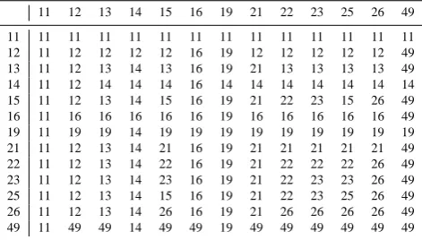
Table 8.Decision matrix indicating the fire type-protection type code of the record to be retained in the FPA FOD from a set includ-ing two or more redundant federal fire reports. The first digit of the code indicates fire type, where 1=actionable (i.e., suppression or appropriate management response taken), 2=natural out, and 4= fuels management (unplanned ignitions only). The second digit of the code indicates protection type, as defined in Table 5.
11 12 13 14 15 16 19 21 22 23 25 26 49 11 11 11 11 11 11 11 11 11 11 11 11 11 11 12 11 12 12 12 12 16 19 12 12 12 12 12 49 13 11 12 13 14 13 16 19 21 13 13 13 13 49 14 11 12 14 14 14 16 14 14 14 14 14 14 14 15 11 12 13 14 15 16 19 21 22 23 15 26 49 16 11 16 16 16 16 16 19 16 16 16 16 16 49 19 11 19 19 14 19 19 19 19 19 19 19 19 19 21 11 12 13 14 21 16 19 21 21 21 21 21 49 22 11 12 13 14 22 16 19 21 22 22 22 26 49 23 11 12 13 14 23 16 19 21 22 23 23 26 49 25 11 12 13 14 15 16 19 21 22 23 25 26 49 26 11 12 13 14 26 16 19 21 26 26 26 26 49 49 11 49 49 14 49 49 19 49 49 49 49 49 49
records with FTPT codes of 11 are to be retained over all others, because that code indicates that the entity with pro-tection responsibility is the reporting entity. When redundant federal records indicated the same FTPT for the same fire (e.g., multiple federal units reporting the same fire and
us-ing FTPT=13, because, although it burned multiple federal
ownerships, it was the responsibility of a non-federal entity), or when sets included only non-federal records, we simply retained the first record of the fire as it occurred in the com-piled data set, sorted in ascending order on FOD_ID. The FOD_ID was auto-assigned in ascending order as records were appended to the Fires table, and federal records were appended in the following order: (1) FS-FIRESTAT, (2) DOI-WFMI, (3) FWS-FMIS. The USFS records, for example, were assigned lower FOD_IDs than the DOI records and would therefore be retained in lieu of redundant DOI records with the same FTPT indicated. Records were “retained” by removing the flag that had been assigned in step 1.
We then repeated the process (i.e., step 1), ignoring any records with a persisting flag, after rounding latitude and longitude to two decimal places to identify additional sets of redundant records illustrated by case 3 (Table 7, step 2). Fire name was not consistently populated in the systems of record, and steps 3 and 4 in our process entailed repeating steps 1 and 2, respectively, with fire name excluded from the queries to flag record sets like cases 4–7 in Table 7. Some fires flagged in steps 3 and 4, which appeared redundant be-cause, according to the reports, they were the same size and discovered on the same date and at essentially the same lo-cation, were likely “false positives” due to imprecision in re-ported fire location. For example, fires located only as pre-cisely as PLSS section generally have a reported latitude and longitude that merely represent the coordinates of the sec-tion centroid, and all fires occurring within that secsec-tion are
thereby apt to have matching location information. There-fore, PLSS section-located fires that were discovered on the same date and that reached the same final size are likely to be flagged as redundant in steps 3 and 4. We presumed, how-ever, that fires greater than 40 hectares flagged in steps 3 and 4 were far more likely to be redundant (i.e., unlikely to
oc-cur in multiples on the same day within the same 2.6 km2
section) than smaller fires, and to avoid purging potentially legitimate records from the database, we only flagged fires
<40 hectares if they matched in terms of size, date, and lo-cation, and were obtained from different agencies or systems of record (e.g., Table 7, case 7). All sets flagged in steps 3 and 4 were visually inspected for false positives before proceed-ing. The name and protection type of the FWS-reported fire in case 7, for example, indicated to us that the record was of a mutual aid fire that was indeed redundant with the record of an unnamed fire reported by the Florida Forest Service (FFS; formerly the Florida Division of Forestry, or DOF), and per our processing rules, only the federal record was retained.
Step 5 was another variation on the previous steps, with coordinates for the persisting subset of data rounded to a single decimal place and records flagged if they matched in terms of name, date, and furthermore the generalized location (but not fire size). This step, again with visual confirmation, allowed us to identify sets of redundant records illustrated by cases 8 and 9 (Table 7), in which the records did not have the same reported location or fire size.
In Step 6, we relaxed the date requirement to year and identified sets of redundant records shown in case 10 (Ta-ble 7), which matched in terms of name, year, general loca-tion (coordinates rounded to one decimal place), and fire size greater than 4 hectares. In step 7, we grouped records of fires greater than or equal to 405 hectares by (1) year and FPU and (2) year and state, and queried and visually inspected the groups to identify sets of redundant records based on match-ing or similar names, dates, and/or fire sizes (Table 7, cases 11–15).
indicated it had protection responsibility; per our processing rules, only the USFS record was retained.
In the next step, step 9, which was the most laborious, we grouped all fires (regardless of size) by year and gen-eral location (coordinates rounded to one decimal place) and identified groups that included records from multiple sources (i.e., different systems of record). We then sorted the records within each group by date and fire size and visually inspected more than 150 000 records, scanning for redundant records that had passed through our screening up to that point. Case 17 (Table 7) provides an example of a set of records identi-fied in this way that had not yet been flagged because they are reports of a<405-hectare fire that agree only on month and location at one decimal place; but given their size (>324 hectares) and the similar dates, we concluded that they re-ported the same incident.
In step 10, we used FIRE_CODE to check for redundant reports from the federal systems of record. The formal Fire-Code system dates back only to 2003, and FireFire-Code is not consistently populated for all fires from the federal systems since circa 2003, so it is of limited use in identifying poten-tial duplicates. Moreover, FIRE_CODE alone is insufficient for this purpose, because fires in complexes (see Sect. 2.2.5) and groups of small (i.e.,<40 hectare, or “miscellaneous ABC”) fires are often assigned the same accounting code in a given fiscal year. We queried the subset of data that persisted through step 9 and generated a list of potentially redundant records based on FIRE_CODE, which was visually inspected to avoid discarding nonredundant fires grouped for account-ing purposes, and those within complexes, which were dealt with separately as described in the following section.
2.2.5 Fire complexes
Operationally, a wildfire complex consists of two or more fires located in the same general vicinity and assigned to a single incident commander or unified command (NWCG, 2012a). In other words, a fire complex effectively comprises multiple fires managed as one large incident. It is not uncom-mon, however, to find fire reports for the complex as well as reports for all or some of its constituent, or subordinate, incidents in the systems of record. Because complexes can cover very large areas (e.g., the 2004 Taylor Highway com-plex in Alaska was reported at more than 500 000 hectares), estimates of total area burned from a database with records of complexes as well as their subordinate fires are apt to be highly inflated. When complexes were identified in the re-porting systems, either via the incident name or by some database flag, we used that information to populate the COM-PLEX_NAME field in the Fires table (Table 6). While that approach identified some of the complexes in the data set, it did little to help us identify and label each of the subordinate fires within complexes when they, too, were reported.
Because they generally are significant incidents, most fed-eral and many non-fedfed-eral fire complexes from circa 1999
forward should have an ICS-209 report in the SIT/209
database. Individual large incidents within the complex should be named, with area burned for each reported, under
Remarks (NWCG, 2012a). In 2010 the SIT/209 database
be-gan including a separate incident complex table that names subordinate fires by complex. Unfortunately, the incident numbers used in the ICS-209 records (see NIFC, 2011) are not required to be included in the agency fire reports, which means that there is no straightforward way to join the records together. The LOCAL_INCIDENT_NUMBER in the Fires table may contain a component of the alphanumeric ICS-209 incident number (i.e., the numeric portion), but the LO-CAL_INCIDENT_NUMBER rarely includes all of the in-formation and is rarely formatted in the manner necessary to join the Fires to the ICS-209 records. The formatting and in-formation content of the incident number used in the ICS-209 reports (e.g., XX-XXX-######) is, however, generally con-sistent with that of the incident order number in the FireCode system, and FIRE_CODE is an attribute in our data set. We were able to acquire federal incident records for 2003–2011 from the FireCode system, and we used those to populate a temporary INCIDENT_NUMBER field in the Fires table (Table 6). We intentionally excluded incident order numbers that were incomplete (e.g., XX-XXX-).
According to recent interagency guidance, all federal wild-fires within a complex are to retain their original FireCodes and incident numbers for accounting purposes (NWCG, 2011). However, when we linked our incident records into FireCode and extracted incident names, we found it not un-common for all incidents within a complex to be assigned the same FireCode and given the complex name. Therefore, simply by linking into the FireCode system, we were able to further populate the COMPLEX_NAME field in the Fires table.
The FireCode system dates back only to 2003, and not all federal reports of wildfires from 2003–2011 were FireCode-populated. For records that we could not populate IN-CIDENT_NUMBER via FireCode, we scoured the LO-CAL_INCIDENT_NUMBER and FIRE_NAME fields for what appeared to be components of the ICS-209 incident numbers and, usually after some reformatting or concatena-tion with other elements the record (e.g., State and Unit ID), we were able to use those components to populate the INCI-DENT_NUMBER field further.
to derive matching incident numbers from the Fires table. We then scoured the ICS-209 incident records for the
sub-set of all fires >405 hectares from 1999 to 2011 in the
Fires table and populated the INCIDENT_NUMBER and ICS_209_INCIDENT_NAME fields for as many additional records as possible, partially through a series of database queries and partially through visual inspection of the data. When we located records of the same event that did not link originally due to differences in incident numbers, we overwrote the INCIDENT_NUMBER in the Fires table with that from the ICS-209 system in order to ensure that IN-CIDENT_NUMBER could serve as a bridge to the ICS-209 information, at least for most fires in the FPA FOD
>405 hectares. Due to inconsistencies in the ways that inci-dent numbers are populated in various information systems, we determined that INCIDENT_NUMBER, as we had de-rived and vetted it, could only reliably be used to join to the ICS-209 records, and we therefore changed the name to ICS_209_INCIDENT_NUMBER and deleted entries that did not join, or joined incorrectly, to ICS-209 records. We then leveraged information in the ICS-209 data set to con-tinue populating COMPLEX_NAME.
The SIT/209 databases for 2010 and 2011 include an
in-cident complex table that names subordinate fires by com-plex, and we capitalized on that information. For the years 1999–2009, however, there is no easy way to find and ex-tract the names of individual incidents within complexes be-cause they are listed, usually among copious other notes, in a memo field (i.e., a data type intended to store large amounts of text). It was therefore essentially a manual exercise to pop-ulate COMPLEX_NAME from the ICS-209 records (when this was possible).
After leveraging the FireCode and ICS-209 systems, we turned to a third national data set to identify additional fires in complexes. The MTBS perimeter data set, which cur-rently spans 1984–2011, was used to further populate COM-PLEX_NAME for fires pre-dating the other two systems and for later fires that our process heretofore had missed. In addi-tion to the FireCode and ICS-209 systems, the MTBS project consults several other sources (e.g., the Wildland Fire Deci-sion Support System, InciWeb, field units) to determine the appropriate complex designations for the fires it has mapped, dating back to the mid-1980s (B. Quayle, personal commu-nication, 2013). The MTBS data set identifies fires in com-plexes via the FIRE_NAME attribute, and in cases in which the fires within a complex remained distinct (unmerged), the complex name is listed, and the name of the subordi-nate (i.e. individually mapped) fire is indicated parentheti-cally (e.g., Canyon Complex [Bear]). It was possible to cor-rectly derive the MTBS_ID (Table 6) for several thousand records by concatenating agency, unit, FireCode, and discov-ery date from the fire records. Fire names and sizes were used to verify that the correct ID had been derived. MTBS_IDs for another several thousand records were populated manu-ally. MTBS_FIRE_NAME (Table 6) was populated once the
records could be joined, and missing complex names were extracted from MTBS_FIRE_NAME.
Once COMPLEX_NAME was populated as completely as possible, we used it to flag records like those illustrated by case 19 (step 11) in Table 7. In that case, the subordinate fires merged into one and continued to grow before reaching the final fire size. We therefore retained only one record of the three in that example, that of the JULY 4TH COMPLEX, in order to accurately reflect the total area burned. In cases in which the total area burned by the complex was adequately accounted for by the individual reports of subordinate fires, we preferentially retained the individual fire records in lieu of the single complex record in order to avoid losing infor-mation.
2.3 Completeness evaluation
We attempted to evaluate, at least nominally, the complete-ness of the resulting data set by comparing estimates of an-nual fire numbers and area burned, by state, from the FPA FOD with other published estimates. To avoid errors associ-ated with mapping imprecision, the FPA FOD estimates were compiled by state based on the nominal STATE attribute, rather than the point location of the fire, although those as-signments agree in 99.9 % of the records.
Because the published estimates of annual wildfire num-bers and area burned can differ considerably among sources due to inconsistencies and errors in measurement and report-ing (e.g., see Urbanski et al., 2009), several sources of ref-erence estimates were included in our assessment. We con-sider agreement in estimates of the same metrics from the FPA FOD and a given reference source as a proxy for “com-pleteness” with respect to the latter. How accurately the ref-erence estimates reflect actual wildfire activity is unknown; however, none are presumed to represent the true values, and therefore completeness, in fact, cannot be known by way of this assessment, or, indeed, at all. In other words, agreement of estimates from the different sources implies nothing about their accuracy.
2.3.1 Sources of reference estimates
year-end summaries of wildfires and area burned according to the SIT reports. During the active fire season (i.e., pre-paredness level>1), SIT reports are required on a daily basis from federal units with fire protection responsibility as well as any non-federal (i.e., state, county, or local) units with pro-tection responsibility for lands under federal ownership (per cooperative agreement). The use of the SIT reporting system is optional for non-federal units with wildfire protection re-sponsibility for non-federal lands. Voluntary SIT reporting by non-federal units may result in considerable underesti-mates of total wildfire numbers and area burned appearing in the NICC annual reports.
If the NICC estimates are low due to limited non-federal reporting through the SIT application in years and for states from which we were able to acquire viable data from the non-federal systems of record, we would expect lack of agree-ment in those cases (i.e., FPA FOD estimates exceeding those from NICC), particularly for states with the majority of their wildland area under non-federal fire protection. To identify states and years for which the NICC numbers appear low due to underreporting of non-federal fires, we relied on several additional sources of published estimates of wildfire num-bers and area burned, as available.
Although the USFS ceased publication of annual wildfire reports in 1997, the agency is still required to collect wildfire activity statistics from state and local units that it supports under its State and Private Forestry Cooperative Fire Assis-tance Program (USFS, 2010). Each participating state’s fire marshal or other authority uses the Annual Wildfire Sum-mary Report (AWSR), form FS-3100-8, to provide the nec-essary summary information, including the numbers and area burned by wildfires responded to by state and local firefight-ing agencies (USFS, 2010). We extracted wildfire counts and area burned estimates from all AWSRs available from the FAMWEB Data Warehouse, by state, for the period 1992– 2011.
Finally, we extracted any all-lands estimates of wildfires and area burned that were published or otherwise made pub-licly available by the states themselves or other interagency groups. We were able to find such estimates, purported to be for all ownerships and spanning the entire period of inter-est (1992–2011), from the Alaska Interagency Coordination Center (AICC), the California Department of Forestry and Fire Protection (CDF), the Southwest Geographic Area Co-ordination Center (SWCC, covering Arizona and New Mex-ico), and the South Carolina Forestry Commission (SCFC). Wildfire activity statistics for state and local ownerships were obtained from the Texas A&M Forest Service (TFS) for 2005–2011.
In sum, we used the USFS/NICC estimates as our default
for comparison to the FPA FOD data summarized by state
and year. When any of the USFS/NICC estimates appeared
to underestimate wildfire numbers or area burned within a state-year based on publicly available estimates from another
authoritative source, we used the latter for the assessment described in the following section.
2.3.2 Methods of assessment
We compared estimates of wildfire numbers and area burned from the FPA FOD to those from the reference sources; this amounted to a comparison of measurement methods, for which many statistical analyses are inappropriate (Bland and Altman, 1986). For example, given the generally high inter-annual variability in fire numbers and area burned, inter-annual wildfire activity metrics from different sources can be highly correlated but have very poor agreement, making correlations irrelevant. Because we were interested in the similarity of es-timates (in relative rather than absolute terms), we calculated, for each state and year, the ratio of (1) wildfire numbers and (2) wildfire area burned estimated from the FPA FOD and the same metrics from the reference source. We did not expect perfect agreement in any case, due to measurement inconsis-tencies and errors. However, if the FPA FOD and the national interagency statistics were based on similar levels of federal and non-federal reporting, and the FPA FOD was nominally complete in that regard, then the estimates of fires and area burned from the FPA FOD should agree with the national
interagency estimates reasonably well (e.g.,±20 %) and the
ratio of FPA FOD numbers to the reference (REF) estimates
should be close to 1. Averaged across years, the FOD/REF
ratio essentially provides an index of agreement for a given period. However, in cases in which the FPA FOD includes records from non-federal sources unaccounted for in the ref-erence estimates (e.g., data from local fire departments) for some years and not others, the average of the ratios can be very near to 1 despite poor agreement in estimates for in-dividual years. We therefore used the ratio simply to score states on a scale of 0–10, by limiting the maximum value of the ratio to 1 and then averaging across years and multiply-ing the resultmultiply-ing value by 10. We used the scalmultiply-ing factor to make the result appear less like the average of the unadjusted ratios in order to avoid confusion. Low scores indicate states for which the FPA FOD appears relatively incomplete for the period of assessment based on national published estimates of wildfire numbers or area burned, while high scores indi-cate states for which the FPA FOD yields estimates of those metrics that tend to meet or exceed those from the reference source(s). We used the entire 20 yr span, 1992–2011, as one period of assessment and the recent 10 yr span, 2002–2011, as a second period, because we expected differences largely due to the increased use of non-federal reporting systems in the latter period.
3 Results
Figure 1.Locations of wildfire records from the conterminous US included in the FPA FOD by year.
in the FPA FOD. The bulk of the data that we acquired were processed in 2010, at which point we limited our focus to records only from the years 1992–2008. At that time, we identified approximately 1.2 million wildfire records from that 17 yr time span that met our geospatial and information requirements, and which we compiled into a single database. Via our process, we identified approximately 120 000, or 10 %, of those records as redundant with others in the data set and subsequently purged them from the final database, thereby eliminating 22 million hectares from the original 58-million hectare data set, or 38 % of the total. In other words, the redundancy we identified in the unprocessed, compiled data set inflated wildfire numbers by a factor of 1.1 and in-flated the estimate of wildfire area burned by a factor of 1.6. During the winter months of 2011–2012, we processed and added data for 2009–2011 as well as newly available records from the non-federal systems that were known to be missing from the 1992–2008 data set. The resulting FPA FOD, spanning 1992–2011, includes nearly 1.6 million wild-fire records, which collectively account for approximately 46 million hectares burned during the 20 yr period. The data set includes wildfire records from each of the 50 US states and from the District of Columbia and Puerto Rico.
The years and states for which at least a subset of data from one or more of the non-federal reporting systems is in-cluded in the final database are identified by the boldface val-ues in Tables 9 and 10. Twenty-one states, including Alaska, afforded at least some viable and non-redundant non-federal data for the entire 20 yr span. Considering just the 10 yr span,
2002–2011, the number of states affording some viable and
non-redundant non-federal data for that entire period rises to 36.
The maps in Fig. 1 show the locations of all of the wild-fire records by year from the conterminous US included in the FPA FOD. A map of the locations of all FPA FOD records in the conterminous US is juxtaposed with a map of land mapped as burnable wildland surface-fuel types (per Scott and Burgan, 2005) in the LANDFIRE Refresh 2008 (LF_1.1.0b; see Ryan and Opperman, 2013) data set in Fig. 2. Figure 3 shows the locations of wildfires in the conter-minous US, 1992–2011, reported as greater than or equal to 405 hectares in the (A) FPA FOD and (B) MTBS perimeter data set, for comparison.
Agreement with national estimates
Figure 2.Locations of (A) all wildfire records in the conterminous US included in the FPA FOD, 1992–2011, and (B) land mapped as burnable wildland surface-fuel types in the 30 m resolution LAND-FIRE Refresh 2008 data set (LF_1.1.0b; see Ryan and Opperman, 2013). Points depicting the locations of fires are not to scale. Areas with few or no fires represented in the data set may have afforded lit-tle viable data for inclusion in the FPA FOD, or, alternatively, may be areas with little or no burnable land cover. Non-burnable fuel types are those with “insufficient wildland fuel to carry wildland fire under any condition”, and include urban or suburban development, agricultural land maintained in a non-burnable condition, snow/ice, open water, and bare ground (Scott and Burgan, 2005).
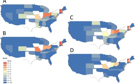
Agreement with published estimates of wildfire numbers and area burned is generally evident for states and years from which non-federal data were available and incorporated into the FPA FOD (Tables 9 and 10). Agreement scores for the 21 states from which we acquired viable non-federal data for all 20 yr ranged from 8.1 to 9.9 for wildfire numbers (Ta-ble 9) and 7.3–9.9 for wildfire area burned (Ta(Ta-ble 10). Our index of agreement is generally high for states and regions with a large proportion of land area administered by one or more of the five primary federal agencies with wildland-fire-management programs (Figs. 5 and 6), as they are least
affected by missing non-federal records. Twelve of the 17
states in the western region scored 8.2 or higher for the 20 yr period for wildfire numbers and area burned, while the re-gion’s west-central states and Hawaii, which have less land under federal administration than Alaska and the far-western states in the conterminous US, scored the lowest of the west-ern region (Tables 9 and 10, Fig. 5a and c). Nine of the ten US states with the lowest 20-year scores, for either metric, are
Figure 3.Locations of wildfires in the conterminous US, 1992– 2011, reported as greater than or equal to 405 hectares (A) in the FPA FOD and (B) in the MTBS perimeter data set. The points in panel A are not displayed to scale, but rather at a size that makes it possible to compare the general spatial pattern of large-fire oc-currence as indicated by the FPA FOD to the large-fire perimeters mapped by MTBS for the same period.
in the northeastern region (Tables 9 and 10, Fig. 5a and c). While they are included in Tables 9 and 10, scores for the states of Iowa, Illinois, Kansas, New York, and Texas are not indicated in Fig. 5, because they are misleading due to reporting biases evident in the FPA FOD and the reference sources (which we describe in the next section and illustrate in Figs. 7–10).
4 Discussion