Copyright © 2015 IJECCE, All right reserved
A Proposed Model for Human Securing using GPS
Avein J. Al-Assady
Information System Dept., Faculty ofComputer & Information Sciences, Mansoura University, Mansoura, Egypt
Bahaa T. Shabana
Computer Science Dept., Misr HigherInstitute for Commerce & Computer, Mansoura, Egypt
Hazem M. El-Bakry
Information System Dept., Faculty ofComputer & Information Sciences, Mansoura University, Mansoura, Egypt
Abstract – This paper presents system architecture for Human security monitoring, which can be used in the personal locators for children, elderly people or those suffering from Alzheimer's or memory loss, and monitoring the movement for law execution. This architecture consists of GPS part for collecting information about a movable object (MO), spatial database part for storing this information by listener server, and finally, Geographic Information System (GIS). Using GIS helps in the display and analysis of spatial information on a digital map. The methods used in spatial data collecting and management are described in details in this work. The spatial database stores information about location (latitude, longitude, date, time, etc) at the time of observation, and some additional desired attributes. GIS provides information about the MO either within the permitted area or outside of it. In this case, the system sends SMS messages that contain the spatial data about the MO to the stakeholders (police, parents, helpers, etc) for giving the assistance as possible.
Keyword – GIS Network, GPS, GSM, GPRS.
I.
I
NTRODUCTIONThis paper presents an effective methodology for controlling movable objects (MOs) and determines the available area for them. It depends on geographic fencing determination, which determines the available area and its fence. This methodology is required in several fields like: tracking a human mobility, following up money transferring vehicles, and those with special needs and protection. The objective in this paper is to construct a system which notifies users when the MO moves near or outside the available fence. The utilization of: Geographic Information System (GIS), Global Positioning System (GPS), and General Packet Radio Service (GPRS) are infrastructure, which are required in this process [1]. The constructed system has to make a connection between GPS and GIS to save spatial data in a database and checking their accuracy as illustrated in Figure 1.
1.1 Geographic information systems
GIS is software that allows an unlimited amount of information to be connected to a geographical location. In addition to the digital map and geographic information systems that allow the user to see the sites, events, features, and environmental changes in more accurate and time-wise manner. In GIS spatial data are stacked as thematic layers, which display information, reveal trends, and the spatial distribution of utilities (i.e., water pipes, electricity, transportation, etc). GIS achieves awareness through the integration of many techniques to provide users with access to information based on their circumstances [2]. GIS provides access to spatial data and enhances the user's ability to understand, respond, and
Making decisions based on a set of circumstances presented in the geographical context. GIS is integrated with many technologies such as remote sensors, GPS devices, enterprise applications, and communication. These technologies can provide contextual computing processing required for getting accurate information about the right place at right time[11-18].
1.2 Global Positioning System
Global Positioning System (GPS) is a system composed of a network of 24 satellites developed by the United States. This system was originally used in military services, and later on it was allowed to be commercially used in many products as demonstrated in Figure 2. The GPS satellites periodically emit radio signal of short pulses to GPS receivers. A GPS receiver receives the signal from at least three satellites to calculate distance and uses a triangulation technique to compute (latitude and longitude) position. However, at least four satellites are required to compute three dimensions (latitude, longitude, and altitude) of a position. Once a location is computed, both the average speed and direction of traveling can be calculated. Therefore, GPS is a key technology for giving the device its position [3].
1.3 Global System for Mobile Communications
Global System for Mobile Communications (GSM), is a cellular phone that is used in different parts of the world Protocol. In the 80s and 90s of the last century, scientists developed a protocol to create a standard cell phone service between European countries. GSM phones use the identity of the unit (SIM) card subscribers, which is necessary for the performance of its functions and allows the user to simply switch phones[4]. In this study, GSM was used for transmitting data messages, whether through SMS or GPRS. The GSM modem is a wireless modem working with GSM in the wireless network. Wireless modem works like dial-up modem, however the main difference between them is that the dial-up modem sends and receives data through a fixed line phone, whereas wireless modem sends and receives data through radio waves. The work system is based on the GSM modem commands [5].1.3.1 General Packet Radio Service
Copyright © 2015 IJECCE, All right reserved transmission data at a rate higher than 115.2 kbps (with
eight slots available for each frame)[5]. Due to a very large coverage area of GSM networks worldwide, GPRS become the largest data network services available and always on. Accordingly, GPRS becomes the most appropriate system for real-time tracking management.
1.3.2 SMS mode
SMS (Short Message Services) is an important technology that has an impact and more economic on our daily life. It is one of the GSM terminal services. Data are transferred via SMS to the Listener Server [6].
1.4. Real-time communication
Real-time tracking management system is an open system that uses a free and open source software and is composed of commodity hardware that is easy-to-find. Our system is composed of three components, a GPS Tracking Device, a server and a database. The GPS tracking device is an embedded system that transmits location information to the server through GPRS networks. The server is a personal computer that receives the information and put it in the database. The database formats the information in a special form that can search and display using GIS or Google Earth software [7].
1.5. Previous studies
A good number of tracking systems have so far been developed with a wide range of tracking facilities [6]. For example, In order to prevent the phenomena of children kidnapping, keeping track of the child has been adopted by using a number of software and hardware as an integrated system. For instances, as mentioned by children shoes, which connect to a belt that contains tracking devices GPS [8], have been employed. Secondly, the zones of a virtual security based on GPS Watch and Sensitive Lock of Skin Pressure have been [9] in order to be a security system in school. Thirdly, the system of child care using GPS as well as the suitable transceiver of Bluetooth have been designed [10]. and finally proposed the major blocks, which are GSM chipsets coupled with SIM cards, an external web server, and a Smartphone application [7]. Even though, but the GPS does not determine precisely the child location unless integrating them with the database in order to store the date and site of the (MO) on the map. Therefore, apply this purpose by making a connection between GPS and GIS to save data in a data base to determining the movable objects location exactly. and send SMS to the stakeholders( helpers, police parents etc ) for giving the assistance as possible. when the person crosses a given border of a predefined zone.
II.
S
YSTEMP
REPARATIONThe proposed system requires integration between three components, which are hardware tools, software packages, and spatial data as follow:
2.1 Software Packages
The software packages used in this work include:
2.1.1 ArcGIS
ArcGIS is developed by the Environmental Service and Research Institute (ESRI) Company. It helps in creating and editing several types of spatial data. The edited
features are stored in two data models: vector or raster. In the vector model features are stored as points, lines or polygons. Data in the vector model include shapefiles, coverages, geodatabases, Triangulated Irregular Networks (TINs), as well as various tabular formats. ArcGIS Editor was used in this work for building geodatabase of the studied area. The created geodatabase consists of a number of feature classes for most features in the studied area, such as streets, buildings, universities and schools.
2.1.2 Listener
A listener is universally known as Sockets. It is an abstraction through which an application may send or receive data. It also provides generic access to inter-process communication services. A Socket method program is executed, assembled and configured to run on the Listener's server startup. Socket software is applied via C# programming language.
2.2 Hardware Tools
Two types of hardware tools were used in this work, which are:
1. GSP tracker
GPS devices were in this work in order to track moving objects (MO). GPS devices have to be connected with the GPS satellites in order to identify the coordinated of the tracked point. The GPS device has to get signals from at least four satellites to identify the coordinates of the point. These GPS devices that contain SIM Cardswere developed to be put in shoes, watch, belts or etc of the person to be tracked. The purpose of attaching this device is to send signals to GSM Towers. GSM Towers in return send the information through GPRS or SMS to Listeners.
2. Server
The server used in this system contains a Listener and a database. It is simply consist of a PC connected to the internet and it has a static IP address. That server should be running 24 hours a day to provide the tracking service for persons and those with special needs. This is in order to send messages (SMS) in time when they need help.
2.3 Spatial Data
The spatial data used in this work includes
1. Map Data:
A geodatabase was created for Al- Mansoura city. This geodatbase consists of streets, residential areas, public services and public buildings (i.e, hospitals, universities, schools, etc). All these features were created by using the ArcGIS software package (ver. 10.1). Al-Mansoura city is located between these coordinates 31o31.05 N and 31.02-31.24 E through google earth.
2. GPS Data:
Copyright © 2015 IJECCE, All right reserved
III.
W
ORKP
ROCEDUREFigure 3 demonstrates sources of data used in this work and the procedures used in their manipulation. ArcMap was used to create tracker systems by applying a set of procedureson the collected spatial data. First, the GPS device identifies the coordinates of the tracked object and sends these coordinates as signals to GSM Towers. The GSM Towers send the information through GPRS to the Listener. The Listener software stores that information in geodatabase (in access format).The developed system was tested inside the boundaries of Al-Mansoura University. These boundaries were edited in ArcMap and stored as polygon feature class in the geodatbase. These boundaries were used as allowed areas and the areas outside these boundaries were used as restricted areas. When the tracked person goes entered the restricted area the system was developed to send an alarm in a form of warning SMS message. To make this works the model builder in ArcToolbox was used to create several models in this regard. The first model was built to select layers by location. Two layers were used in this model, which are the event table of the tracking point and the boundaries of Al-Mansoura University (named as city_polyon in the geodatabase) as represented in Figure 4.
The second model was used to select the tracking points outside the boundaries of Al-Mansoura University. It is similar to the first model; however the switch selection was used instead of select layer by location. The inputs of this model were the outputs of the first model as illustrated in Figure 5.
The third model was used to save tracking points recorded outside the selected zone. The saving process goes through a certain loop, to keep track of the continuously received data. This model going through several stages;
The first step using model (Make Feature Layer) the
input (Table1 Events(4)) and output
(Table1_Features_layer). The second model used (Copy Rows) input model (Table1_Features_layer) and output (Table2_Copyout). The third model used (Table to Table) have two entrances first input (Table2_Copyout), a second input (ChildTrack.mdb) and output the third model(Output Table) as illustrated in Figure 6.
The process will work when object moves outside the boundaries. Then system will send a message as a result of the interruption process between the object movement and bounder. so the system sends SMS consist of (longitude , latitude, time date and speed) to the stakeholders (parents ,police ,etc)
IV.
E
XPERIMENTALR
ESULTSThis study presents a system to resolve the human security by tracking the Moving Objects (MO). The potentials of GIS and GPS are used the data that interested of tracking the objects. Objects represent wide range of elements such as special needs, children, VIP etc. The proposed system collect; the data by GPS be sent to the server through GPRS and finally, save a spatial data in
database. These Data are received by Listener then stored in a geodatabase, GIS track liabilities utility to determine the available area, and the location of the accepted GPS location (current location).the current location may be inside or outside the available area. Couple conditions will be processed by the proposed system as follows:
Inside: the system stores data without interruption of the bounders. The system does not send a message as a result of the interruption process.
Outside: the system stores data of the interruption process between the object movement and bounder. The system does send a message as a result of the interruption process.
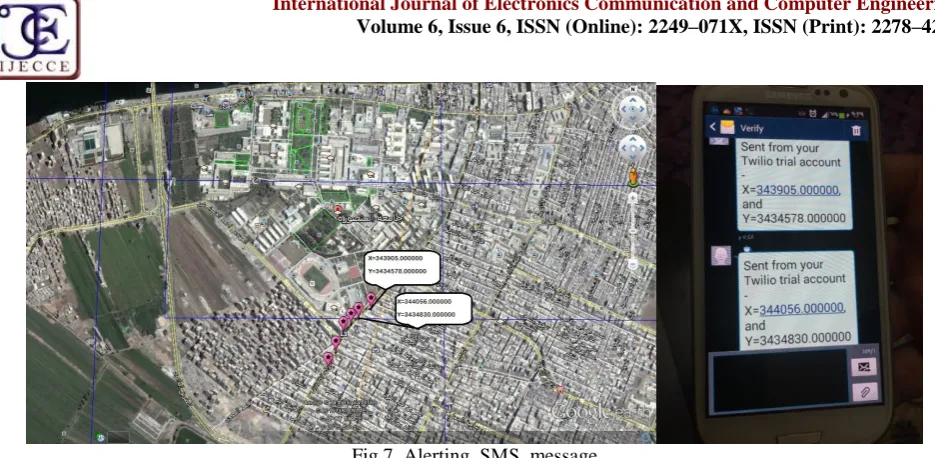
It is necessary to mention that the (SMS) message consist of (longitude, latitude, time date and speed) which send to the stakeholders (helpers, police parents etc) for giving the assistance as possible as illustrated in Figure 7.
The system is performed, tested and calculating the arrival time of message depending on the speed of person whom being tracked, where the system is applied on many cases:
The first case when the person walks and crossing the allowed area.
The second case when the person using a car. in this case the time of message arrival will be change depending on car's speed .
while that the time arrival of alert's massage is 6 second after crossing the border the allowed , and will continue sending a messages while the person out of the allowed area. This is specified in the settings of the (GPS-Tracker) advance.
V.
C
ONCLUSIONThis paper presented a development of tracking system which is used in the human security. The integration among GIS technologies, GPS tracker and SMS are utilized for tracking the movable objects (MO) that has the capability to real-time observe MO. The proposed system sends a message automatically when MO moves outside the available areas. The system determines the non-available areas by determining the MO location with respect to the available area (polygon), by using the algorithm of point location w.r.t. polygon. The proposed system has many advantages such as low costs effective, Strong expandability and Easy to use, it is used in many fields to control the available areas for any MO.
R
EFERENCES[1] Kok Sun Wong, Wei Lun Ng, Jin Hui Chong, Chee Kyun Ng, Aduwati Sali, Nor Kamariah Noordin, " GPS Based Child Care System using RSSI Technique," 15 -17 December 2009, Kuala Lumpur Malaysia.
[2] Public Safety and Homeland Security Situational Awareness. ESRI February 2008.
Copyright © 2015 IJECCE, All right reserved [5] R. J. Bates, GPRS: General Packet Radio Service, McGraw-Hill
Professional, 1st Edition, ISBN 0071381880, November 12, 2001..
[6] H. Tan, 2010., Design and Implementation of Vehicle Monitoring System Based on GSM/GIS/GPS, Second International Conference on Information Technology and Computer Science, 413–416, Nanjing
[7] Ayman Mohamed Afifi , "Using of Tracking systems for devices designing to face children Kidnapping Phenomenon (GSM – GPRS -GPS)," International Journal of Scientific and Research Publications, Volume 3, Issue 10, October 2013 1
[8] Pradeep Rajan Jayashree , "Virtual Security Zones for Student Tracking and Elderly Fall Alert Based on GPS Watch and Skin Pressure Sensitive Lock," 2013, Department of Electronics and Communication Engineering, Jaya Engineering College, Thiruniravur – 602024., Tamilnadu, India
[9] Child Safety Reporting System Midyear Design Report. http://www.ecs.umass.edu/ece/sdp/sdp14/team13/Reports/MDR. pdfAbstract— The Child Safety Reporting System (CSRS) is a .... Report. Michael L Wood, EE, Josh Hodge, EE, Ethan Cabral, CSE, andKenneth Cabral, CSE. A ., 2013.
[10] GPS Based Child Care System using RSSI Technique. http://ieeexplore.ieee.org/iel5/5423778/5431381/05431460.pdf% 3Farnumber%3D5431460
Kok Sun Wong, Wei Lun Ng, Jin Hui Chong, Chee Kyun Ng, Aduwati Sali, Nor Kamariah Noordin. Department of Computer and Communication Systems Engineering, Faculty of Engineering, University Putra Malaysia,. UPM Serdang, 43400 Selangor, Malaysia, 2010.
[11] Nama Al-Shumanny, Bahaa T. Shabaha and Hazem El Bakry, ―A Proposed Decision Support System for E-Services Based on GIS,‖ International Journal of Electronics Communication and Computer Engineering, vol. 6, issue 5, September 2015, pp. 602-607.
[12] Raid S. Sarhan, Bahaa T. Shabaha and Hazem El Bakry, ―Design of an Efficient Integrated System for Ambulance Management,‖ International Journal of Electronics Communication and Computer Engineering, vol. 6, issue 4, July 2015, pp. 509-515. [13] Hesham Ahmed Hassan, Hazem El-Bakry, and Hamada Gaber
Abd Allah, ―Design of Multi-Criteria Spatial Decision Support System for Improving Animal Production,‖ IAES International Journal of Artificial Intelligence, vol. 2, issue 3, September 2013, pp. 117-124.
[14] Hesham A. Hassan, Hazem M. El-Bakry, and Hamada Gaber Abd Allah, ―A Novel Spatial Decision Support System for Improving Animal Production,‖ Proceedings of the 12th International Conference on Artificial Intelligence, Knowledge Engineering and Data Bases (AIKED '13), Cambridge, UK, February 20-22, 2013, pp. 49-54.
[15] Hesham Ahmed Hassan, Hazem M. El-Bakry, and Hamada Gaber Abd Allah, ―A New Multi-Criteria Spatial Decision Support System for Improving Animal Production,‖ International Journal of Computational Linguistics and Natural Language Processing, vol. 1, issue 12, December 2012, pp. 186-191.
[16] Hesham A. Hassan, Hazem M. El-Bakry, and Hamada Gaber Abd Allah, ―Visualization for Levels of Animals Diseases by Integrating OLAP and GIS,‖ International Journal of Computer Science and Information Security, vol. 10, no. 7, July, 2012, pp. 44-50.
[17] Hesham A. Hassan, Hazem M. El-Bakry, and Hamada Gaber Abd Allah, ―A New Approach for Computing Levels of Animals Diseases,‖ Proceedings of the 6th WSEAS European Computing Conference (ECC '12), Prague, Czech Republic, September 24-26, 2012, pp. 281-290.
[18] Hazem M. El-Bakry, and Wael A. Awad, ―Geographic Information System for Railway Management,‖ Proc. of 3rd WSEAS International Conference on Visualization, Imaging, and Simulation (VIS’10), University of Algarve, Faro, Portugal, November 3-5, 2010, pp. 149-162.
Copyright © 2015 IJECCE, All right reserved Fig.2. GPS integration in commercial products
Copyright © 2015 IJECCE, All right reserved
Copyright © 2015 IJECCE, All right reserved
Copyright © 2015 IJECCE, All right reserved
Copyright © 2015 IJECCE, All right reserved Fig.7. Alerting SMS message
Table 1: Simulation results for all cases.
Case Speed Distance severed to receive SMS
Case 1 Walk 6 m
Case 2 Car(40 Km\1h) 83 m
Case 1 Car(50 Km\1h) 100 m