Forestry & Natural-Resource Sciences Last Correction: Apr. 9, 2015
ALGORITHMS FOR ESTIMATING THE SUITABILITY OF
POTENTIAL LANDING SITES
Nils Egil Søvde
Norwegian Forest and Landscape Institute, ˚As, Norway. Molde University College, Molde, Norway
Abstract. Cable yarding systems are commonly used in steep or difficult terrain and require suitable
landing sites. This work describes two algorithms that calculate the suitability of roads and areas for landing site use. The algorithms were tested against real world data. The results show that simple algorithms are sufficient to make stable, useful estimates that are comparable with human site placements. These techniques can be used to guide forest road network planning or reuse of existing roads.
Keywords: landing assessment, forest planning, forest operations, forest harvesting, cable
yard-ing
1
Introduction
Cable yarding is an important part of forest oper-ations, as it is the primary system of harvesting steep and difficult terrain. In this system, a forest unit is harvested by a layout of cableways covering the unit of the forest. Cableways collect timber from the unit and transport it to a landing site for temporary stor-age. The landing sites must be situated along the forest roads in appropriate positions. The choice of position for a landing site has a significant impact upon the ease and profitability of operations. On the one hand, cableways are time-consuming to set up, which affects production and profitability. On the other hand, the storage capac-ity and landing layout may lead to operational delays. Large landing sites can enhance the productivity of the machines at the landing along with better access to the timber trucks. The gradient of a site is also important. Cable yarding is primarily used in steep terrain, and landing sites with locally shallower inclines are easier to operate and can store more timber.
It is useful to classify two types of landings. A
land-ing by convention is any part of a road where a yarder
is set up. A landing by construction1 is a built area
typically used for larger cable yarders. In this paper
a possible landing is any area around a point on a
for-est road or in the terrain evaluated for landing suitabil-ity. Acandidate landing is a possible landing which has been selected as promising by an expert or mathemati-cal model, and used in a subsequent optimization model
1These two classifications are not found in the literature, but may be helpful to think about.
or decision support system.
When planning operations, potential landing sites can be identified by an expert forester visiting the op-erations area. This requires an extensive site evaluation in person and a suitable skillset, which introduces costs and delays.
Forest operations could be made more efficient by systematically identifying potential sites using comput-ers and remote sensing. Currently, commercial software exist to support decision making about sites and ca-bleways (e.g. PLANX (Epstein et al. 2001), RoadEng2, CYANZ3), but these assist manual site surveying rather than replacing it.
This paper therefore identifies an unaddressed need for increased automation of landing site placement pro-cesses, and an opportunity to reduce manual surveying requirements and costs. The specific problem addressed here is: ‘For a given map, what is the suitability of each point as a landing site, based on a digital terrain model?’. The question, in this formulation, has not been studied before. Here, suitability is defined in terms of the storage capacity and truck access potential of the landing.
Two algorithms will be introduced that compute in-dicators of landing site suitability across a map, using only a digital terrain model derived from remote sensing data. These algorithms simplify the process of decision making, and if implemented in industry they will reduce or remove the need for an extensive manual site survey.
2url: www.softtree.com
3url: http://www.harvestpro.co.nz/CYANZ.html
Copyright c2015 Publisher of theMathematical and Computational Forestry & Natural-Resource Sciences
This is the main contribution of this article.
After describing the algorithms, this paper analyses their behaviour and performance in several ways.
• A qualitative visual comparison of the output of the two algorithms.
• A comparison against real sites that were chosen in the area as part of a previous harvesting.
The findings are that both algorithms quickly pro-duce similar results, which are comparable with previous site placement, without the need for further data input. Although there are opportunities for further study, the work appears to be suitable for practical use.
2
Research problem context
2.1 Planning and optimization Planning and
opti-mization techniques have numerous applications in forestry, in operational, tactical and strategic planning (Church et al. 1998, Martell et al. 1998). Sometimes the objective is to enhance environmental values or public goods, but a more common goal is to maximize profits. The largest contribution to forest revenues comes from the sale of timber. The major costs associated with this are the cost of harvesting and transportation, and the cost of road construction. The latter cost is inherently strate-gic, as a permanent forest road will be useful for decades or centuries, whereas harvest planning and transporta-tion planning are operatransporta-tional planning problems.
Currently, these problems are addressed at differ-ent levels of detail and calculation resolution, but de-velopments in computers and remote sensing may al-low detailed strategic planning models to be solved effi-ciently. This would bridge the gap between operational and strategic planning.
2.2 Systems of harvesting and yarding Different
harvesting systems are used throughout the world, and a large part of the harvested timber is produced using ground based systems. In steep or difficult terrain, or where soil compaction or other environmental concerns are present, cable yarding systems are commonly used (e.g. Bont 2012). Cable yarding systems generally have a higher cost than ground based systems, because of the increased need for manual labor, and consequently there is more opportunity to reduce total costs through improved planning.
A commonly used yarding system in Europe is based on trucks equipped with a tower and a crane for process-ing and on-site movprocess-ing of timber. The trees are felled manually and yarded to the landing as whole trees. The trees are processed at the landing, and stacked for later transportation directly to the mill. The preferred har-vesting method in Europe is the cut-to-length method.
Also, timber trucks are typically equipped with a crane for loading, and thus, no loader is required.
European yarding systems operate largely in a paral-lel pattern along roads (Bont 2012). With the assump-tions that only existing roads, and only landings by con-vention are used, this is a problem where the sum of rigging costs and yarding costs, only, can be minimized. While the tower can be rigged at almost any location on the road, the terrain at a landing location will affect the productivity. The timber has to be released, processed and stored at the landing, and if the landing is too small, the operations are restricted. Truck loading costs may also increase at small or poorly positioned landings.
In contrast, American cable yarding systems are in general larger than the European systems, and com-monly used tree length methods requires more space for log storage. To meet these requirements, landings have to be constructed, or, if there exist old landings, they may have to be extended. Assuming that existing roads are used, this is a problem consisting of landing construction cost, rigging cost and yarding cost. The construction cost of a landing site is dependent on the terrain before construction, and use of a landing may incur extra costs if the resulting landing is too small. For this case, manual landing evaluations may be time consuming, and automated landing evaluations may im-prove the cost estimates.
2.3 Operational analysis in forest operations An
early example of operational analysis of cable yarding systems and road location is Dykstra and Riggs (1977), who formulated a facility location model for the Ameri-can cable yarding problem including yarding cost, cable-way rigging cost, landing construction cost and road con-struction cost. This formulation is a hierarchical prob-lem, as the roads, landings, cableways and yarding are at different levels. A solution for one level depends on and affects the solutions at all other levels. Hierarchical problems are inherently difficult to solve to optimality. Their work is not directly applicable to the European problem, as experienced in Norway.
The time or computational resources needed to solve a difficult optimization problem are highly influenced by the problem instance size. For spatial planning, the variables are commonly linked to a grid or some repsentation of the terrain. The instance size can be re-duced by changing the grid resolution or by restricting which grid points that can be selected (e.g. as landing or road). The selection of candidate landings for cableway planning and road location problems is usually manually performed by human experts (Dykstra and Riggs 1977, Chung 2002, Epstein et al. 2006, Bont et al. 2012).
as possible landings can be large, and thus it is neither straightforward or trivial to obtain manual landing site evaluations for all possible landings. Computer systems may be used to assist human analysis, but these systems do not independently select candidate landing sites and there is little discussion of approaches to this problem in existing literature.
The idea behind this paper is therefore to replace the role of the expert with a suitability estimation algorithm. This would improve the speed of analysis, reduce costs and delays, and has the potential to improve the quality of the evaluation relative to manual analysis.
Furthermore, in terms of productivity studies (as op-posed to site selection), presently there are no examples in forestry literature describing how to estimate land-ing site usage costs from digital terrain models as part of overall forest operational analysis. The technique of this paper might provide the basis of a cost model.
Chung (2002) analyzed possible landings by numeri-cally calculating the feasibility of 36 cableways radiating from the possible landing in a star-shaped pattern, and the landing was graded by the size of the area that could be harvested by the cableways. This method was also used by St¨uckelberger (2008), who used the results for guiding the optimization of new forest road locations. Although the forest area covered by a landing is an im-portant feature of a good landing, their method disre-gards the importance of the terrain close to the tower yarder.
2.4 Specific problems addressed in this paper
The aim of this study was to design algorithms to pre-dict the quality of possible landings on a local scale, and compare the algorithms. Such algorithms can link productivity studies aimed at finding cost parameters in forestry, and forest planning research. Whereas for-est planning research has been utilizing high resolution spatial data for some time (a recent review is Akay et al. 2009), there are few reports of productivity studies linked to spatial location in general, and landings in particular. The first algorithm calculates the amount of timber that can be stored at a road location. The second algo-rithm returns a mean absolute elevation difference of a point and points in its close vincinity, and is thus easier to calculate and is not limited to road locations. The two algorithms were tested with a real world forest site, and the results compared. The results were compared with the landings used when the area was harvested pre-viously. These were manually identified from aerial pho-tographs. Finally, some rules of thumb for landing as-sessment are briefly discussed.
3
Method
3.1 Problem definition The specific problem addres- Erratum
Apr.9’15
sed here is: ‘For a given map, what is the suitability of each point as a landing site, based on a digital terrain model?’. Here, suitability is defined in terms of the stor-age capacity and truck access potential.
One of the key characteristic of a good landing is the possibility to stack logs, while still being able to process more trees. The timber volumes that can be stored at a road location depend on the road profile extended some meters into the terrain, depending on the reach of the crane of the equipment subsequently handling the wood. Algorithm 1 was designed to estimate the amount of timber that can be stored at a possible landing. The inputs to the algorithm are a Digital Terrain Model (DTM) and the road location. From the possible land-ing, the centerlines of the road some distancedc in front
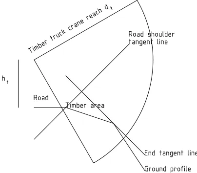
and behind are located, and ground profiles perpendicu-lar to the centerlines are found at reguperpendicu-lar intervals (Fig-ure 1). If the gradient between the road shoulder and the point some distancedl(i.e. the maximum log length)
from the road shoulder is not too steep, the logs can be piled perpendicular to the road, and the maximum tim-ber pile area at that ground profile line is dl×hmax,
where hmax is the maximum timber pile height
(Fig-ure 2).
Figure 1: An example of locations of profiles used for the volume calculations. dc is the distance (in front and
behind) included in the calculations. dlis the log length.
If the profile is steeper, the timber has to be stacked parallel to the road (Figure 3). In this case, the reach of a timber truck is considered first, omitting areas beyond the reach. Secondly, the maximum piling angle of timber is assumed to be 45◦, and two tangent lines are found,
possibly reducing the stacking area further. One line intersects the road shoulder, and the other line either intersects the timber truck crane reach, or is a tangent to the ground profile.
Figure 2: Calculated pile area with perpendicular stack-ing. dl is the log length and hmax is the timber pile
height.
Figure 3: Calculated pile area for steep profiles with par-allel stacking. dtis the timber truck crane reach andht
is the height of the timber truck crane boom attachment.
the landing suitabilityf is found as the sum of the mean absolute values of the elevation differences between the landing grid point and grid points within a radiusdr of
the landing. If the terrain is flat,f will be close to zero, but f will increase with steeper terrain. f is essentially measuring the steepness of the terrain.
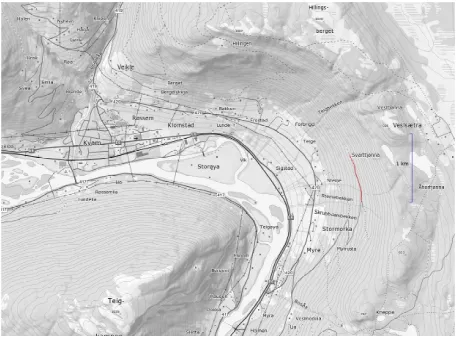
Both algorithms were tested for a real world terrain near Kvam in Gudbrandsdalen in Norway (lat. 61.658◦, long. 9.755◦), shown in Figure 4. The DTM was gener-ated from airborne laser scanned data, and a 1m×1m
grid was used. For Algorithm 1, the centerlines in front and behind were of length dc = 10m, the
perpendicu-lar ground profile length was dp = 7.5mand the
maxi-Algorithm 1MaxLandingVolume
1: Find road centerlines ahead and behind the possible landing (of lengthdc).
2: V ←0
3: forroad centerlines ahead and behinddo
4: Find average spacingLbetween grid points of the center-line.
5: forgrid pointsxjin centerlinedo
6: Find left and right ground profile lines (pland pr) per-pendicular toxj(of length (dp)).
7: forplandprdo
8: Find the gradient g from the road shoulder to the ground point one timber length (dl) distance off the road.
9: if |g| ≤gmaxthen 10: A←dl×hmax
11: else
12: Find point on ground profile line within reach of a timber truck.
13: Find the line 45◦up from the road shoulder.
14: Find the line 45◦ down that tangents the ground
profile.
15: Find the line at road elevationzr+hmax. 16: A←the minimum area above the ground profile
and below the three lines.
17: end if
18: V ←V +A×L
19: end for
20: end for
21: end for
22: return V
Algorithm 2SumOfAbsoluteDifferences
1: zi←the elevation at grid pointxi. 2: f←0
3: n←0
4: forgrid pointsxjwithin radiusdr ofxido 5: f←f+|zj−zi|
6: n←n+ 1
7: end for
8: return f /n
mum gradient was gmax = 0.25. The maximum timber
length wasdl= 5.5mand the maximum pile height was
hmax= 2.5m. The cranes of timber trucks were assumed
to be attached to the truck at a height ofht= 3m, and
the maximum crane reach dt= 7.5m. For Algorithm 2
the radius was set todr= 10m.
To compare the algorithms, the values returned by the algorithms were normalized. The normalized volume was ˆV = (V−Vmin)/(Vmax−Vmin), and the transformed
normalized landing score was ˆf = 1−(f−fmin)/(fmax−
fmin). As the normalized volume and the transformed
normalized landing score both are between zero and one, the two methods can be compared usefully.
4
Results
val-Figure 4: A map of the area where the forest road is located (red curve).
ues along the road are plotted in Figure 5.
Algorithm 2 returned landing scores that ranged from 0.24mto 2.46m. The values along the road are plotted in Figure 6.
The normalized values returned by the two algorithms are plotted in Figure 7, together with vertical lines rep-resenting the landings manually identified from aerial photographs by the author.
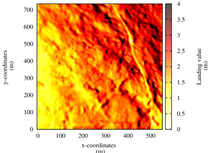
Algorithm 2 was also tested with the entire area of the terrain, and returned landing scores between 0.22m
and 6.22m. A heat map of the results is given by figure 8. To improve contrast, the scale was limited to 0 – 4m(i.e. black represent values 4m– 6.22m).
5
Discussion
Qualitatively, the results returned by Algorithm 2 were compared with the results of Algorithm 1 in Fig-ure 7. The results from the two algorithms diverge at some parts of the road, but the derivatives of normalized landing score along the road are more consistent. When the landing score of one algorithm increases, the landing score of the other increases too.
Figure 7 also shows that the landing scores relate quite well with the landings used by the yarding con-tractor historically. The exit of the forest road is to the right in Figure 7, and the harvesting system processed the trees on this side of the truck. Landings (numbered from the left) 1, 2, 3, 4, 8, 9, 10, 13 and 14 all have increasing landing scores to the right of the vertical line. Landings 5, 6, 11 and 12 have decreasing landing scores, but the landing scores are in general above average.
For Landing 2 and 3 both algorithms returned low landing scores, and the landings are close to each other. This may be due to the fact that Landing 1 and 2 were located at a different property than Landing 3. Keeping
the harvesting of each property separate may have lead to suboptimal landing selection by the contractor. We do not know if this was a constraint on their work.
Both Algorithm 1 and Algorithm 2 ran quickly - a few seconds of CPU-time for the road and the area calcu-lations. The algorithms are summing a finite set of val-ues, and the computational complexity is O(n), where
nis the number of evaluated points.
These landing suitability indicators can be used both for cable yarding systems and ground based systems. The indicators can be used as input for several plan-ning problems, including cableway and tower location planning, for limiting the number of candidate landings in such problems, and for estimating landing and road construction costs.
5.1 Using landing scores to improve cableway
location planning for small tower yarders In the
European system, small tower yarders do not use con-structed landings. Instead, they use any suitable loca-tion on existing roads. Such operaloca-tions could be mod-eled as a facility location problem including rigging as a facility building cost and yarding as a facility usage cost. However, the quality of the landings may also affect the profitability of the operation.
One approach could be to add a landing use cost in the objective function. This is not straightforward, as the landing use cost is highly stochastic and a result of interaction between the yarder and the truck remov-ing timber (as well as the processor, in cases where the yarder is not equipped with such.) The yarder may ex-perience reduced productivity due to delays, inefficiency or timber handling, and the loading of the truck may be inefficient if timber has to be short hauled to tem-porary storage or to the truck trailer. Also, the truck routing may be inefficient if the truck has to rush to the landing to relieve the yarder. There are no published studies of landing use costs, and defining a cost function is presently guesswork. One possible approach might be to estimate the total timber volume to be harvested at the landing, as well as the landing score, and define a two-dimensional table or function returning estimated costs.
If there are very many candidate landings, heuristic or metaheuristic solvers may be required depending on the problem instance size and complexity instead of algo-rithmic approaches. If the number of candidate landings has to be reduced, the landing score can be used as a cut-off.
5.2 Selecting candidate landings from all
100 150 200 250 300 350 400 450 500 550 600 650
0 100 200 300 400 500 600 700 800
Calculated maximum landing volume
(m
3)
Road point index
Figure 5: Maximum landing timber volumes along the road. The road point index is an index of a linked list of road center points snapped to the closes grid point.
0 0.5 1 1.5 2 2.5
0 100 200 300 400 500 600 700 800
Calculated mean absolute elevation difference
(m)
Road point index
Figure 6: Sum of absolute differences along the road. The road point index is an index of a linked list of road center points snapped to the closes grid point.
The problem of selecting candidate landings was briefly discussed by Chung (2002) but is not formally defined in the literature. Which qualities should a good candidate landing set possess? Some possible criteria are:
1. All or most of the candidate landings should have a good landing score.
2. The set of candidate landings should be dispersed along the forest road to cover the area, at least for small yarders operating in parallel.
3. The set should be small enough to meet the re-quirements of the solver of the cableway location problem.
Unfortunately, criteria 1 and 2 can conflict, as the land-ing score may vary along a forest road.
The problem of how to reliably select the best can-didate landings from all possible landings is beyond the scope of this paper. The landing scores from these two algorithms may be a useful tool.
5.3 Estimating landing construction cost and
road construction cost Landing construction costs
are seldom discussed in the literature. Road construc-tion costs are more studied, and Heinimann (1998) in-cluded a cut area contribution as well as a drainage contribution and a pavement surface contribution in the cost calculations. It is reasonable to assume that a sim-ilar cost function could be used for landing construction costs.
Figure 7: Normalized volumes (red) and transformed normalized landing scores (blue) along the road. The vertical lines show the location of landings identified from aerial photographs. The road point index is an index of a linked list of road center points snapped to the closes grid point.
0 100 200 300 400 500 600 700
0 100 200 300 400 500
y-coordinates
(m)
x-coordinates (m)
0 0.5 1 1.5 2 2.5 3 3.5 4
Landing value
(m)
Figure 8: Heat map of the sums of absolute differences.
will result in low landing scores, whereas steep terrain yield high landing scores. Thus, the landing score will be correlated with cut volumes, and can be used for estimating the cut volume contribution to both landings and roads.
5.4 Landing scores for road planning One
advan-tage of Algorithm 2 over Algorithm 1, is that it can be used for any point in the landscape, not only roads. This feature can be useful for choosing the location of forest roads. The landing score shown in Figure 8 can be used in the same manner as in St¨uckelberger (2008), though these measures are looking at different problems in site placement.
6
Conclusions and future research
Two algorithms were developed for landing detection and evaluation, and tested against data from a real world site. The results show that the two algorithms have a similar ability to locate potentially good landings, and that volume storage capacities vary along the road. Fur-thermore, Algorithm 2 can be used for evaluating areas of terrain, a necessary feature when planning new forest roads.
It might be interesting to investigate how the micro topography in the vicinity of landings affects the cost of yarding operations.
Landing suitability has an impact on forest planning, and should be incorporated in industrial optimization models.
Funding source and acknowledgements
This work was partly funded by the Norwegian Re-search Council (grant NFR186912/I30). I would like to thank Dr. Graeme B. Bell for proofreading and com-ments improving the manuscript. Thanks are also due to three anonymous reviewers, for their time and helpful comments.
References
Akay, A., H. O˘guz, I. Karas, and K. Aruga, 2009. Using lidar technology in forestry activities. Environmental Monitoring and Assessment 151(1-4):117–125. URL
Bont, L. G., 2012. Spatially explicit optimization of forest harvest and transportation system layout under steep slope conditions. Ph.D. thesis, ETH.
Bont, L. G., H. R. Heinimann, and R. L. Church, 2012. Concurrent optimization of harvesting and road net-work layouts under steep terrain. Annals of Opera-tions Research pp. 1–24. URL http://dx.doi.org/
10.1007/s10479-012-1273-4.
Chung, W., 2002. Optimization of cable logging layout using a heuristic algorithm for network programming. Ph.D. thesis, Department of Forest Engineering, Ore-gon State University.
Church, R. L., A. T. Murray, and A. Wein-traub, 1998. Locational issues in forest man-agement. Location Science 6(1–4):137 – 153.
URL http://www.sciencedirect.com/science/
article/pii/S0966834998000515.
Dykstra, D. P., and J. L. Riggs, 1977. An applica-tion of facilities locaapplica-tion theory to the design of for-est harvfor-esting areas. A I I E Transactions 9(3):270– 277. URLhttp://www.tandfonline.com/doi/abs/
10.1080/05695557708975155.
Epstein, R., A. Weintraub, P. Sapunar, E. Nieto, J. B. Sessions, J. Sessions, F. Bustamante, and H.
Mu-sante, 2006. A combinatorial heuristic approach for solving real-size machinery location and road de-sign problems in forestry planning. Operations Re-search 54(6):1017–1027. URL http://dx.doi.org/
10.1287/opre.1060.0331.
Epstein, R., A. Weintraub, J. Sessions, B. Sessions, P. Sapunar, E. Nieto, F. Bustamante, and H. Mu-sante, 2001. Planex: A system to identify landing locations and access. In Proc. of the International Mountain Logging and 11th Pacific Northwest Skyline Symp. P. Schiess and F. Krogstad [Eds.]. December, pp. 10–12.
Heinimann, H., 1998. A computer model to differentiate skidder and cable-yarder based road network concepts on steep slopes. Journal of Forest Research 3(1):1–9.
URLhttp://dx.doi.org/10.1007/BF02760286.
Martell, D. L., E. A. Gunn, and A. Weintraub, 1998. Forest management challenges for operational re-searchers. European Journal of Operational Research 104(1):1 – 17. URL http://www.sciencedirect.
com/science/article/pii/S0377221797003299.