Research).
ESF is the European association of 76 major national funding agencies devoted to scientific research in 29 countries. It represents all scientific disciplines: physical and engineering sciences, life, earth and environmental sciences, medical sciences, humanities and social sciences. The Foundation assists its Member Organisations in two main ways. It brings scientists together in its Scientific Forward Looks, Exploratory Workshops, Programmes, Networks, EUROCORES (ESF Collaborative Research Programmes), and European Research Conferences, to work on topics of common concern including Research Infrastructures. It also conducts the joint studies of issues of strategic importance in European science policy and manages, on behalf of its Member Organisations, grant schemes, such as EURYI (European Young Investigator Awards).
It maintains close relations with other scientific institutions within and outside Europe. By its activities, the ESF adds value by cooperation and coordination across national fron-tiers and endeavours, offers expert scientific advice on strategic issues, and provides the European forum for science.
European Polar Board (EPB)
The European Polar Board established in 1995, is the ESF Expert Committee on issues of polar sciences. It is the only European polar organisation that covers science policy issues in both polar regions. EPB is composed of the directors and senior managers of European polar nations and enables cooperation between European national funding agencies, national polar agencies and research organisations. EPB is engaged in dialogue and cooperative actions with important international partners such as the United States and Russia. It provides strategic advice on polar science policy to the European Commission, national governments and international polar bodies.
Acknowledgements: Principal Editors:
Professor Jörn Thiede and Dr Paul Egerton
The European Polar Board wishes to thank its member organisations and Individuals who have contributed to the development of this document. Details of participants and major contributors are presented in the appendices.
COPYRIGHT: European Science Foundation
Cover pictures:
AURORA BOREALIS:
A Long-Term European Science Perspective for
Deep Arctic Ocean Research 2006-2016
Foreword by ESF Chief Executive 3
Executive Summary 5
A Vision of European Collaboration in the Arctic Region 8
The Science Perspective – Introduction 10
PART 1
The Arctic Ocean and Global Climate Change 13
The Arctic Ocean and Global Climate Change – Introduction 14
ATMOSPHERE 18
Atmospheric Forcing, Clouds and Composition of Arctic Air Masses 18
SEA ICE 19
Albedo Radiation and Atmosphere-Ice-Ocean Heat Exchange 19 The Role of Upper Ocean Processes for Extent and Thickness
of the Sea Ice Cover 20
The Dynamics of Biological Systems in a Sea Ice-Covered Arctic Ocean 21
Satellite Remote Sensing 23
Remote Sensing Validation 25
OCEAN 26
Arctic Ocean Circulation 26
Water Mass Conversions on Arctic Ocean Shelves 29
The Role of Polynias for the Water Mass Conversions of the Arctic Ocean 30 Ventilation of Arctic Ocean Waters by Shelf-Basin Exchange 31
Biodiversity in the Central Arctic Ocean 32
Interactions between Arctic Shelf, Slope and Deep Sea Bio-systems 33 Air-Sea Carbon Dioxide Flux Feedbacks in a Changing Arctic Ocean 34
Contaminants 35
PART 2
Modern Geodynamics and Hydrothermalism 37
Modern Geodynamics and Hydrothermalism – Introduction 38 Vent and Seep Communities in the Arctic 39 The Deep Biosphere beneath an Ice-Covered Ocean 40 Impacts of the Siberian Shelf Seas 41 Seafloor Processes with a Geological Impact 43
PART 3
The Arctic Ocean and its Geological History 45
The Arctic Ocean in Geological History – Introduction 46 The Formation of the Arctic Ocean Basin 46 Changes in Arctic Hydrography 47 Extreme Climates – Learning from the Past to Explain the Future 48 The Stability of the Offshore Permafrost 49
PART 4
Technical Requirements for Achieving Arctic Science Goals 51
Technical Requirements for Achieving Arctic Science Goals – Introduction 52 Mission Types for the AURORA BOREALIS 52 Technical Requirements for Marine Geophysics 53
Alternative Solutions 54
Technical Requirements for a High Arctic Drilling Vessel 54 AURORA BOREALIS Conceptual Study 55 Special Technical Aspects of AURORA BOREALIS 58 Environmental Impact and Protection 60 Justification for a Technical Feasibility Study 60
PART 5
Planning, Financing and Management of a Dedicated European
Arctic Research Platform 61
Planning, Financing and Management – Introduction 62 The Concept of the AURORA BOREALIS within EPB EUROPOLAR 62 The Management of the AURORA BOREALIS 63 Financial Options for the AURORA BOREALIS Project 63 Logistical Considerations for the AURORA BOREALIS Project 64 Ice Management System, Satellite Monitoring 65 A 10-Year Outlook for the AURORA BOREALIS 65
APPENDICES 67
I. The Development of the Science Perspective 68 II. Abstract of JEODI Arctic Site Survey Workshop 72
III. References 74
IV. Acronyms and Abbreviations 78 V. Institutional Affiliation of Contributors
to the AURORA BOREALIS Science Perspective 79
Foreword
T
his Science Perspective document of the European Polar Board and ECORD has been developed by participants from over 20 countries throughout Europe and represents a truly pan-European project highlighting some of the major scientific challenges in the Arctic over the next 10 years. Scientific investigations in the central Arctic, including an understanding of the evolution of the climate record and structure of the Arctic Basin through deep drilling, will be critical in the next phase of European and international research efforts in the Polar Regions.The international working group involved in this project proposes a unique and novel infrastructure: AURORA BOREALIS, a dedicated European research icebreaker with a deep drilling capability. This facility would enable Europe and its international partners to achieve an unparalleled understanding of the dynamic processes of this sensitive region, which is so critical for understanding the impact of global climate change.
The forthcoming International Polar Year (IPY) 2007-08 provides an opportunity to launch such a groundbreaking and truly European project.
Professor Bertil Andersson
Executive Summary
P
olar Regions and in particular the properties of northern and southern high latitude oceans are currently a subject of intense scientific debate and investigations because they are (in real time) and have been (over historical and geological time scales) subject to rapid and dramatic change. Polar Regions react more rapidly and intensively to global changes than other regions of the Earth. Observations showing the shrinking of the Arctic sea ice cover, potentially leading to an opening of sea passages to the north of North America and Eurasia en route to a “blue” Arctic Ocean, as well the calving of giant table icebergs from the ice shelves of Antarctica are examples of these modern dynamics.Until now it has not been clear whether the profound change in all parts of the Arctic is a natural fluctuation or is due to human activity. Since this change is a phenomenon of decades, long time data series of atmospheric and oceanic conditions are needed for its understanding and prediction of further developments. Despite the strong seasonality of polar environmental conditions, research in the central Arctic Ocean up to now could essentially only be conducted during the summer months when the Arctic Ocean is accessible to the currently available research icebreakers.
European nations have a particular interest in understanding the Arctic environment with its potential for change because highly industrialised countries spread into high northern latitudes, and Europe is under the steady influence of and in exchange with the Arctic environment. In addition, considerable living and non-living resources are found in the Arctic Ocean, its deep sea basins and their adjacent continental margins. Modern research vessels capable of penetrating into the central Arctic are few. A new state-of-the-art research icebreaker is therefore urgently required to fulfil the needs of European polar research and to document a multinational European presence in the Arctic. This new icebreaker would be conceived
as an optimised science platform from the keel up and would enable long, international and interdisciplinary expeditions into the central Arctic Ocean during all seasons of the year.
Global climate models demonstrate the sensitivity of the polar areas to changes in forcing of the ocean climate system. The presence or absence of snow and ice influences global heat distribution through its effect on the albedo, and the polar oceans are the source of dense, cold bottom waters, which influence thermohaline circulation in the world’s oceans. This global conveyor is a major determinant of global climate.
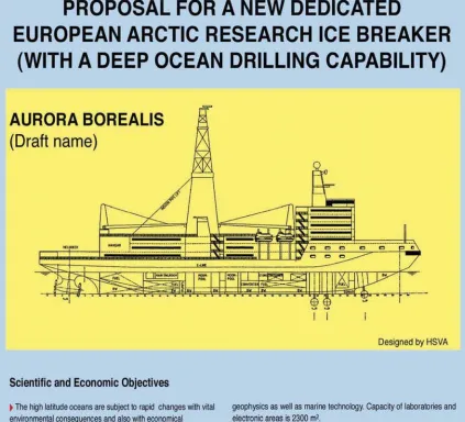
In spite of the critical role of the Arctic Ocean in climate evolution, it is the only sub-basin of the world’s oceans that has not been sampled by the drill-ships of the Deep Sea Drilling Project (DSDP) or the Ocean Drilling Program (ODP), and its long-term environmental history and tectonic structure is therefore poorly known. This lack of data represents one of the largest gaps of information in modern Earth Science, also relevant for the field of hydrocarbon exploration. Therefore, the new research icebreaker AURORA BOREALIS (Fig.1)
should be equipped with drilling facilities to fulfil the needs of the IODP (Integrated Ocean Drilling Program, begun in 2003) for an alternative platform to drill in deep, permanently ice-covered ocean basins. The icebreaker must also be powerful enough to keep on-station against the drifting sea ice cover and will have to be equipped with dynamic positioning.
An effective use of the new research icebreaker requires the formation of a consortium of European countries and their polar research institutions to ensure a high quality of science and efficient employment of the research vessel during all seasons of the year. Extensive and well-developed Arctic research programmes exist in several European countries, particularly in the Scandinavian countries, Russia and Germany. Different organisations or working groups, with rather diverse structures and domestic impact, exist in each individual country. The construction of AURORA BOREALIS as a joint European research icebreaker would result in a considerable commitment of the participating nations to co-ordinate and expand their polar research programmes in order to operate this facility continuously and with the necessary efficiency. If AURORA BOREALIS is eventually established as
a European research icebreaker for the Arctic, European polar research will be strengthened; and Europe will be able to contribute to meeting the Arctic drilling challenge within IODP.
However, from a long-term perspective, the AURORA BOREALIS could also be used to address Antarctic research targets, both in its mode as a regular research vessel as well as a polar drill-ship. The international nature of the Arctic research perspective and of IODP should also be open to participation by non-European countries.
A Vision of European
Collaboration in the
Arctic Region
…The critical role of the Arctic in regulating and driving the global climate system is one that requires elucidation in all its complexities. This is necessary to predict future
environmental changes and determine strategies that must be adopted by nations to protect the functioning of the Earth system...
European nations have a particular interest in understanding the Arctic environment with its inherent sensitivity to change. The Arctic Ocean contains considerable living and non-living resources. The interactions and effects of human influence must be understood in order to develop adequate means of protection and potential scientific and economic use of this unique environment. The development of a dedicated European research platform icebreaker will enable the study of physical, chemical and biological processes in the Arctic regions during all seasons of the year and will promote internationally integrated and multidisciplinary science programmes based on a unique large research facility. The AURORA BOREALIS project is a core element of the European Polar Board’s strategic framework EUROPOLAR and is a concept which enables strengthening, expansion and commitment to the organisation and implementation of European polar research.
Global climate change amplified in the high Arctic has a profound effect on circumArctic populations. This is particularly seen in the social and economic damage arising from more frequent climate-induced extreme events. Anthropogenic feedbacks into the cryosphere-atmosphere-ocean system need to be investigated and evaluated with much greater
precision. A dedicated European scientific research platform will significantly contribute towards observation and monitoring of changes in the environment at high latitudes. Polar marine research over the next 10 to 15 years will concentrate on the long-term natural variability within the ecosystems of the Arctic Ocean. This will focus on the feedbacks between atmosphere, sea ice, ocean and biological systems. In particular the propagation of anomalies through the system is used to understand the pelagic ecosystems during the different seasons, the response of planktonic systems and benthic biota to variations in sedimentation and river supply as well the distribution pattern of anthropogenic contaminants in the Arctic.
Climate models demonstrate the sensitivity of the Arctic Basin to changes in forcing of the ocean climate system. Snow and ice cover influence global heat distribution and the polar oceans are the source of dense, cold bottom waters that influence thermohaline circulation in the world’s oceans. The global conveyor is a major determinant of climate. In spite of the critical role of the Arctic Ocean for climate evolution in the Northern Hemisphere, it is the only sub-basin of the world’s oceans that has not been sampled by any scientific drill–ship, and its long-term paleoenvironmental history and tectonic structure is poorly known. This lack of data represents one of the largest gaps of information in modern Earth Science. Drilling and sampling of the Arctic Basin will be one of the major scientific and technological challenges of this decade and one in which Europe will play a key role. It could form a major European contribution to IODP (Integrated Ocean Drilling Program) and the AURORA BOREALIS could be considered one of the premier European alternative platforms.
implementation of a European Arctic Observing System using AURORA BOREALIS will open up long-term perspectives to international programmes and enable greatly enhanced knowledge and sound policy advice to be given to governments on the status of changes to the global environment.
This Science Perspective will provide a basis for future scientific investigations of the High Arctic and define a decadal forward-looking strategy for European cooperation in Arctic science.
The present Science Perspective developed by the European Polar Board has mainly an Arctic focus because sufficient research capabilities will be available in Antarctic waters for the coming decade. However, considering the bipolar research interest of many of the European and polar research programmes, it is clear that the AURORA BOREALIS project also has the ability to conduct all-season research and deep sea drilling activities in the ice-infested waters of the Southern Ocean. The annual transit of research icebreakers between Arctic and Antarctic waters is not an efficient mechanism. Once a decade of dedicated research has been carried out in the Arctic Ocean, an assessment will be made of the scientific capability of the AURORA BOREALIS for mission-specific purposes in the Southern Ocean, and whether it could provide an efficient and modern research platform for those waters.
June 2004
Jörn Thiede
Chairman of the AURORA BOREALIS International Science Planning Committee and former Chairman of the European Polar Board of ESF with
The Science Perspective
-Introduction
The AURORA BOREALIS project addresses two scientific communities which in part overlap and in part have divergent interests. The first one is the general polar science community, which requires a research vessel for conducting its field and sea work throughout all seasons of the year, hence with wide scientific perspectives. The other is the deep sea drilling community, which would use the ship mainly during the summer months to study the structure and properties of the oceanic crust and the history of the oceanic depositional environments that can be deduced from the oceanic sediment cover. This has never been carried out in a systematic way in the permanently ice-infested waters of the Arctic, whereas around Antarctica substantial progress has been achieved by using the drilling platforms of the Deep Sea Drilling Project (DSDP) and the Ocean Drilling Program (ODP) during the ice-free seasons and by using a small drill rig from the landfast sea ice very close to shore (CRP, Cape Roberts Project).
As outlined later, AURORA BOREALIS is currently thought of as an Arctic research vessel with a deep drilling capability. In the long term, however, it also has an Antarctic perspective because neither the CRP-tools nor the conventional drilling vessels, which cannot enter ice-infested waters, are able to cover all desirable drilling locations off Antarctica. Many of these locations have not so far been investigated, mainly due to the lack of a suitable ice-capable drilling platform. These scientific targets will now receive renewed attention.
Europe requires new and additional research capabilities to venture into the deep, permanently ice-covered Arctic Ocean. The novel research vessel AURORA BOREALIS will provide such a facility and it should be planned as a European infrastructure unit. It has to be supported by a core group of European countries with relevant research interests; for example, problems in basic research or highly applied research such as fossil hydrocarbon exploration.
From the romantic and heroic times of the early explorers, science in the Polar Regions has evolved into a modern, quantitative branch of the natural sciences, which employs large groups of researchers and sophisticated, expensive instrumentation contributing indispensable data for better understanding the extreme habitats of the Polar Regions as well as their impact on the global environment. The fact that much of the necessary data can be collected only by dedicated research vessels, from permanently manned stations or during expeditions involving many different disciplines and substantial logistic efforts, has resulted in complex interdisciplinary experiments, which can be co-ordinated only under the framework of close international cooperation.
Most of today’s scientific polar research problems are thematically oriented and require inter- and multidisciplinary cooperation. They comprise elements of fieldwork, of modelling and of application and a close cooperation with many national and international partners. Hence, this document contains a comprehensive, though not necessarily complete, science perspective for Arctic and, to a lesser degree, also Antarctic research. However, it must be clear, that planning a large and novel research icebreaker results in a scientific programme that is focused on research disciplines and activities that require a ship with the capability of year-round operations in the central Arctic.
High latitude polar oceans and land areas have a high impact on the global environment; they actually control large segments of the global environment and they can be considered drivers of global climate change. This holds true in particular for Europe and for the Arctic Ocean because the interplay between the North Atlantic Ocean and the Arctic Ocean results in a large anomaly of the climatic zonation of the Northern Hemisphere. Hence, European nations have an all-important interest in understanding the Arctic Ocean, its properties and their natural variability as well as their interaction with the adjacent temperate ocean basins. Many European nations therefore support polar research not only in Antarctica but in the Arctic as well and it is indeed a special characteristic of many of the European polar research programmes to have a bipolar perspective.
The urgency of opinions and decisions about the future of the global environment has resulted in large polar research efforts in many nations. At the present time the perspectives of polar research for the coming decades in the Northern and Southern Hemisphere high latitude regions are evaluated, defined and strengthened in many ways.
The science perspective of the AURORA BOREALIS presents a strategy of deploying a powerful tool for carrying out research in the central Arctic Ocean throughout the entire year for a decade or more in this poorly known ocean basin. All indications point to a time of rapid change in the Arctic, and some scientists speculate about a “ blue ” Arctic Ocean in 50 years from now. The coming decade will be a critical phase in this development especially in the light of the proposed International Polar Year 2007-08 as a platform for an enhanced focus on the Polar Regions.
The central deep sea basins of the Arctic Ocean have yet to be visited by a scientific drill-ship and it is henceforth paramount, under the auspices of IODP, to deploy platforms to solve the following mysteries:
.
the plate tectonic origin of the Arctic Ocean.
the nature of the major structural highs as wellof the oceanic crust on the other parts of the Arctic Ocean
.
to probe for long sediment cores of undisturbed stratigraphic sequences recording the properties of a warm Arctic Ocean prior to the onset of the Northern Hemisphere glaciation.
the traces of the earliest ice covers sometimeduring the Miocene
.
the variability of the glacial and interglacial climate system during the latest part of the Cenozoic.The technical requirements necessary for the intended research require a large and powerful research vessel that can endure very unfavourable weather and ice situations, is able to position itself dynamically against a drifting sea ice cover mainly without the assistance of other icebreakers and which is strong enough to hold its position precisely enough to be able to carry out deep sea drilling. It also calls for the routine deployment of novel, strong propulsion systems as well as for the development of a large icebreaker with one to two moon pools for the deployment of the drilling instrumentation, ROVs and AUVs as well as deployment of sensitive instrumentation during very unfavourable weather conditions. The dual-purpose research vessel will require flexible laboratory arrangements and it is intended to develop a system of modularised and containerised labs, which can be designed and modified according to the needs of a variety of missions.
late autumn, winter and early spring seasons) and will allow European nations to maintain their leading position in Arctic and Antarctic research.
At the same time the AURORA BOREALIS can be considered as a floating laboratory bringing together a sizeable scientific community during an uninterrupted series of multidisciplinary/ interdisciplinary and multinational/international expeditions. It can indeed be considered a floating university and it will be spacious enough to allow the indigenous people of the Arctic–rim countries to contribute and participate in this research, which will collect data and gain insight into the environment on which they depend.
The Arctic Ocean
and Global Climate
Change – Atmosphere,
Sea Ice & Ocean
Part 1
Assimilated GOME total ozone 30-11-99 12h
KNMI/ESA
The Arctic Ocean and
Global Climate Change –
Introduction
The temperature increase in the Arctic during the last 50 years is three times larger than the global average and can be taken as an indicator of global change in the Arctic. The Arctic
atmosphere-sea ice-ocean system reacts to and modifies these changes. Marine biota, CO2-fluxes and human living conditions are affected.
Improved understanding of this system is needed to distinguish between the natural and anthropogenic variations and to build up predictive capabilities.
The coupled atmosphere-sea ice-ocean system in the Arctic represents an integral part of the global climate system by its effect on the heat balance
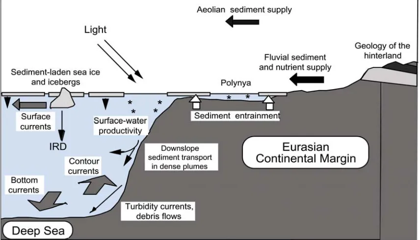
which is strongly affected by atmospheric and sea ice conditions in the Arctic as well as by the formation of dense water masses which spill over the sills into the North Atlantic Ocean and feed into the global overturning circulation (Houghton et al., 2001). Sea ice and ocean waters give home to a variety of biota, which are supplied through river and aeolian input with materials (and nutrients) from the land. The vertical flux of dissolved and particular organic and inorganic matters into the deep sea provides a basis of benthic life (Fig. 2).
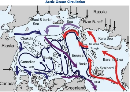
The Arctic Mediterranean Sea comprises the Arctic Ocean with the adjacent shelf seas and the Nordic Seas (Aagaard et al., 1985). It consists of a series of ocean basins separated by ridges, and its internal circulation is to a large extent determined by the basin structure (Aagaard et al., 1985; Aagaard and Carmack, 1994; Rudels, 2001) (Fig. 3). Relatively warm and saline water enters the Nordic Seas from the North Atlantic and is advected through the Fram Strait and the Barents Sea into the Arctic Ocean (Rudels et al., 1994). The Atlantic water re-circulates along different paths in the Arctic Mediterranean, undergoing extensive modification (Rudels et al., 1999a). River runoff from the continents adds a significant volume of freshwater,
and water of lower salinity is supplied by the Pacific through the Bering Strait (Carmack, 2000). Due to the large-scale sea level inclination there is a net transport of low salinity water from the Pacific to the Atlantic which, in spite of its comparatively small volume, constitutes a major control in the global freshwater cycle (Jones et al., 1998). The severe climate, with winter temperatures far below 0oC and the strong stratification in the upper part of the water column caused by the freshwater input leads to ice formation and to the maintenance of a seasonally variable, but currently perennial ice cover in the Arctic Ocean (Wadhams, 2000).
The circulation in the Arctic Mediterranean is driven by wind and by thermohaline processes. The air pressure distribution is basically determined by a high-pressure system over the Beaufort Sea and a low-pressure system over the Nordic Seas leading to an anticyclonic atmospheric circulation pattern over the Arctic Ocean (Przybylak, 2003), which induces a large-scale
Fig. 3: Schematic circulation of upper layer water (thick arrows) and intermediate water (thin arrows). The flow of Atlantic water follows the red arrows, the return of freshwater from the Pacific Ocean to the Atlantic Ocean the dark blue arrows originating at the Bering Strait. The straight arrows represent the mouths of the major rivers (Anderson, 2002).
oceanic circulation (Proshutinsky and Johnson, 1997). The seasonally varying ice cover responds to the winds and the ocean currents, and the anticyclonic circulation of the Beaufort gyre and a less developed cyclonic counterpart in the European Arctic feed into the Transpolar Drift, which provides the major export of sea ice and low salinity upper waters through the Fram Strait. Upper, less saline, water masses also exit the Arctic Ocean through the Canadian Arctic Archipelago into the Labrador Sea.
The Fram Strait is the only deep connection between the Arctic Ocean and the Nordic Seas, where exchanges of intermediate and deep waters take place (Rudels et al., 2000; Fahrbach et al., 2001). The denser water masses eventually leave the Arctic Mediterranean as overflow waters and supply the source waters for the North Atlantic Deep Water, which plays a significant role in the global overturning circulation (Dickson et al., 2001).
The export of both dense and less dense water from the Arctic Mediterranean allows it to exert control on the meridional overturning circulation (MOC) of the global ocean in two ways: 1) the dense overflow drives the lower limb of the MOC; and 2) the low salinity outflow affects the stratification and thus the deep water formation in the North Atlantic which also contributes to the MOC (Rudels, 2001). Variation in these two outflows thus has consequences reaching far beyond the local conditions in the Arctic Mediterranean (Fig. 4). Paleoclimate records suggest that such “rapid changes” could have occurred over time scales of a few decades (Seidov et al., 2001).
During recent years significant changes have been observed in the Arctic, and decadal variations in the atmospheric conditions, sea ice and water mass distribution, and in the oceanic circulation are evident (Thompson and Wallace, 1998; Dickson et al., 2000; Proshutinsky et al., 2002; Dukhovskoy et al., 2004). A decrease and eastward shift of the Beaufort high in the 1990s is described as part of the Arctic Oscillation (AO), which is related to the North
Atlantic Oscillation (NAO). The NAO reflects the variations of the pressure difference between the Azores high and the Icelandic low (Hurrell, 1995). Changes in atmospheric forcing modify ocean circulation and sea ice export, which influence the residence time and the ice thickness in the Arctic Ocean, and the exchanges between the Arctic Ocean and the Nordic Seas.
The changes in the Arctic during the last decade, including their impact on human life, are subject to intense research efforts such as the Arctic Climate Impact assessment (ACIA) initiated by the Arctic Council and such as SEARCH http:// psc.apl.washington.edu/search/, ACSYS/CliC, CLIVAR, ASOF. A basic prerequisite for a substantial study is the existence of long, spatially well resolved, time series of ocean, atmosphere and sea ice parameters and fluxes, and an improved understanding of the physical processes active in the Arctic Mediterranean, and how they respond to varying conditions. Both time series and process studies are mandatory for any serious attempt in modelling possible future changes.
The severe conditions in the Arctic Ocean, in particular its ice cover, make even the exchange of moored systems, deployed to measure transports at “choke points ”, difficult, and to obtain, regularly, hydrographic sections to World Ocean Circulation Experiment (WOCE) standard in the interior of the Arctic Ocean is largely beyond the capability of the existing research vessels. The dynamically active period in the Arctic Ocean, as well as in the Nordic Seas, is winter. During winter the dense water formation on the shelves takes place, and much of the sinking of dense water down the continental slope may occur before summer. Winter is also the time when extensive cooling of the surface water occurs and the wind is strong, supporting an intensive uptake of atmospheric carbon dioxide. Furthermore, during this season the haline convection in the basin interior is expected to penetrate through the halocline into the Atlantic Layer, should the stratification in the upper, interior Arctic Ocean weaken.
To study these processes when they are active, not just record traces of their presence, an icebreaker of exceptional capabilities is required, and not just for one winter but for extended periods. The Arctic Ocean is large and what are the most active and important areas have not yet been determined. The relevant investigations are strengthened by multidisciplinary studies, including chemical tracer work with the need to sample waters during the winter season. This sampling must be performed under conditions that avoid the samples freezing; for example. through a moon pool.
Biological studies in the Arctic Ocean aim on seasonal aspects of sea ice and pelagic biota at ice- covered high latitudes. Investigations of the deep Arctic Ocean will include:
.
investigations on hydrothermal vent communities along the Gakkel Ridge.
studies on bacterial communities inhabiting in the deep biosphere of ocean basins characterised by low productivity.
research on cold seeps along the Eurasian continental slope.
the installation of long-term observatories at key locations in the ice-covered Arctic Ocean.The majority of past expeditions to the Arctic were conducted during the summer season. Therefore, a sound database on the biology of organisms inhabiting the sea ice, the water column or the seafloor is available for many regions of the Arctic Ocean and its surrounding shelf seas during this period of a year. In contrast there are only few and randomly scattered samples taken in the central Arctic Ocean and very little information is available on seasonal aspects such as reproductive cycles, overwintering strategies and metabolic adaptations during winter. Additionally, we have only limited information about species composition and distribution in the three marine sub-systems (cryosphere, pelagic and benthic realm) for the central Arctic. Any profound discussion about latitudinal gradients in marine biodiversity needs more systematic sampling, as well as the identification of shifts in distribution patterns of species due to any effects of global change.
The Arctic Ocean system also plays an important role in taking up carbon dioxide from the atmosphere (Anderson and Kaltin, 2001). The mechanisms controlling this uptake is twofold: the cooling of the surface water increases the solubility of carbon dioxide, and the extensive primary production in some regions decreases the partial pressure of carbon dioxide of the water surface. The combination of extensive uptake of atmospheric carbon dioxide and deep-water production makes the area a significant sink of anthropogenic carbon dioxide.
Atmosphere
Atmospheric Forcing, Clouds and
Composition of Arctic Air Masses
The atmospheric circulation and radiation properties as clouds and aerosols are major elements of the global heat budget and have to be included realistically in global climate models. Arctic data are urgently needed.
The Arctic atmospheric circulation and the interaction between atmosphere, ice and ocean form the physical interactive processes controlling the climate in the Polar Regions, extending their reflections south to sub-polar regions. Significant changes in atmospheric parameters become obvious (Serreze et al., 2000; Comiso, 2003). In terms of global climate change the importance of the Arctic atmospheric circulation and atmosphere ocean interaction may be compared with the crucial role of ocean convection and overturning of the Arctic waters, as driving forces for the thermohaline circulation and hydrography of the world ocean.
In recent years, working tools have been introduced to characterise the physical behaviour of the Arctic atmospheric circulation and the atmospheric forcing, such as the Arctic Oscillation Index (AO) and North Atlantic Oscillation Index (NAO) (Thompson and Wallace, 1998, 2000a & b; Dickson et al., 2000).
The best coupled atmosphere-ocean models suggest the Arctic Polar Regions to be most exposed to global warming (Houghton et al., 2001; Pryzbylak, 2003). The main reasoning for this lies in the role of polar radiation balance and clouds (Fig. 5). Increased atmospheric moisture and cloudiness and changes in the composition of the polar atmosphere decrease the polar thermal (long-wave) radiation out to space, and thus enhance the greenhouse effect. Clouds, on the other hand, have also an opposite effect because the upper clouds reflect the down-welling solar radiation out from the Earth’s atmosphere. Changes in the composition in the atmosphere, such as aerosols, have an important role in this overall balance but are not too well known and modelled. Special aerosols and chemicals, additionally, play a major role in the cold polar stratosphere and in the ozone hole context (Harris et al., 1998).
Observations of clouds and composition of the polar atmosphere can be carried out by remote sensing and special automatic stations. Satellite methods have good spatial and temporal coverage. However, most of the quantities wanted are derived by inverse methods and remain too inaccurate because of incomplete ground check and validation. Therefore, in-situ observations and vertical soundings of the physical and chemical composition and mechanisms of the atmosphere over the Arctic Ocean are necessary in a sustained manner. In practice, those observations can be made only from mobile marine platforms. Because observations and monitoring are necessary over all seasons and regions, a strong ice-going polar ice research vessel is needed as a quasi-permanent platform.
Sea Ice
Albedo Radiation and Atmosphere
-Ice-Ocean Heat Exchange
Sea ice and albedo play a central role in the Arctic Ocean heat budget because sea ice limits the heat exchange between ocean and atmosphere and the albedo determines the reflection of incoming radiation.
The sea ice and albedo of sea ice play the central role in the ocean-ice-atmosphere interaction and heat exchange (Eicken and Lemke, 2001). A high summertime albedo, reflecting the most part of the global radiation back to the atmosphere, is the precondition to formation of multiyear sea ice (Maykut and Untersteiner, 1971). On the other hand, even slight changes in the Arctic albedo may change the sea ice conditions, atmosphere-ocean interaction and heat exchange drastically. Actually, modelling and estimation of the polar albedo remains one of the most crucial issues for predicting scenarios of global climate change. Unfortunately, the albedo in the Arctic is still rather poorly known, quantitatively. Some fixed measured time series over the seasons exist but as they result in a set of complex physical processes the variations in albedo
are not properly known and modelled (Curry et al., 2001). A related difficulty is a high spatial and temporal variability and patchiness (Fig. 6). A good part of the patchiness is caused by local differences in sea ice structure, snow thickness and atmospheric forcing. Rough estimates of large- and regional-scale albedo can currently be retrieved from satellites, but they cannot serve as a basis for modelling and prediction; local observations and physical modelling efforts are still necessary. Additionally, the derivation and prediction of the Arctic albedo is, most likely, connected with the progress of global change, and therefore to new facets of study and time scale predictions.
During recent years, retreat and thinning of the Arctic sea ice has been reported (Vinnikov et al., 1999; Rothrock et al., 1999; Wadhams and Davis, 2000; Comiso, 2002; Rothrock et al., 2003). In those reports, the changes have been (surprisingly) rather distinct. However, the characteristics of the regional distribution of time-scale variations make it difficult to distinguish between natural variability in decadal time scales and the potentially human-caused climate change. Only sustained measurements will allow convincing conclusions. However, the example below should give an idea of the importance of accurate and realistic information of the Arctic sea ice cover.
The studies referred in Houghton et al. (2001) conclude the summertime Arctic sea ice extent to have been decreased from the late 1950s to l990s by 10-15%. Accordingly, if we assume the snow-covered Arctic sea ice albedo to be of the order of 0.8, the above decrease in the sea ice extent would mean an order of 30% more short-wave radiation gain in spring and summer in the whole Arctic Ocean, compared with the previous conditions.
Accurate determination of structure and concentration of sea ice in the broken Arctic ice fields is necessary for modelling sea ice dynamics, with regard to energy exchange between the ocean and the atmosphere. We know that the turbulent ocean-atmosphere exchange of heat and moisture from leads and cracks is the most intense (Launiainen and Vihma, 1994). Accordingly, fluxes via leads and cracks of 5% of the area are comparable to those from the sea ice-covered areas. Therefore, the sea ice concentration should be determined more accurately than is currently carried out using the best satellite image-derived algorithms.
The necessary field studies for better investigation and modelling of albedo, sea ice structure and concentration, snow properties and ocean-ice-atmosphere exchange can only be made from marine/sea ice platforms, available all year round and able to operate in large areas.
The Role of Upper Ocean
Processes for Extent and
Thickness of the Sea Ice Cover
Extent and thickness of the Arctic sea ice cover are affected by heat fluxes from the upper ocean, which can vary due to changes in the stability of the water column caused by changes of the water mass properties.
The strong stability of stratification in the upper part of the Arctic Ocean water column limits the depth of winter convection and allows for cooling of the surface water to freezing temperature and to ice formation (Rudels et al., 1999b). The heat content of the intermediate depth layers of Atlantic water has a capacity to melt about 20m of ice, should it be brought to the sea surface and in contact with the ice cover. However, this requires intensive stirring and turbulent entrainment and may occur only at the continental slope where the rapid flow and topographically trapped and enhanced motions increase the turbulent activity and bring the Atlantic water closer to the sea surface. This is the case at the Eurasian slope in the Nansen Basin. At the slope beyond the Laptev Sea and in the interior of the deep basins, excluding the Nansen Basin, a halocline with temperatures close to freezing is located between the upper Polar Mixed Layer and the Atlantic water. Cold, not warm water is entrained into the mixed layer and no melting takes place.
from below into the mixed layer?” Is the necessary turbulence in the mixed layer generated by the mechanical stirring caused by wind and drifting ice, or is it created by the haline convection induced by freezing and brine release during winter?
Regardless of process, the winter is the only period when entrainment into the Polar Mixed Layer occurs, since a low salinity melt water layer is present at the surface in summer (Rudels, 1999b, 2001). No significant atmospheric cooling is present and the stability in the upper part of the Polar Mixed Layer is too strong for wind-generated turbulence to reach the lower boundary of the Polar Mixed Layer and no entrainment takes place. In winter the stabilising melt water layer is removed by freezing and entrainment of underlying water into the Polar Mixed Layer becomes possible. In the absence of a cold, intermediate halocline entrainment, warm Atlantic water would reduce the ice formation and thus also reduce the release of salt. The decrease in stability at the lower boundary of the mixed layer during winter then becomes smaller than when cold water is entrained.
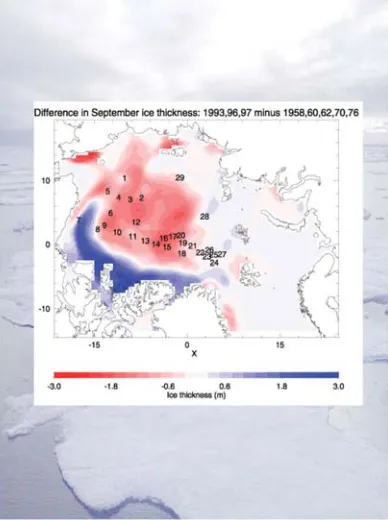
Fig. 7: Difference in September ice thickness: 1993 / 96 / 97 minus 1958/ 60/ 62/ 70/ 76.
(Holloway and Sou, 2002)
The strength of the entrainment depends inversely upon the stability at the base of the mixed layer, and the interactions with the ice cover, induced by entrainment of warm water, provides a negative feedback that acts to reduce the entrainment.
In the special case when the turbulence driving the Atlantic water into the mixed layer is generated by convection, strong entrainment of warm water could temporarily shut down the ice formation and thus the convection, causing the turbulence in the mixed layer to weaken and the entrainment to disappear. Furthermore, convection is a poor mixing mechanism, and much of the cooling of the Atlantic water could actually occur at the lower boundary of the mixed layer when dense, haline plumes penetrate into the underlying warmer Atlantic layer. The heat of the Atlantic water is then not brought to the surface to supply heat to the atmosphere and to melt ice, but is used to heat the cold plumes within the water column.
To understand the complex interactions between sea ice and the underlying waters, observations from numerous sites in the interior of the Arctic Ocean during the active winter season are required. Observations that best can be made from an icebreaking vessel, either directly or from the ice with the ship as a base.
The Dynamics of Biological
Systems in a Sea Ice-Covered
Arctic Ocean
Sea ice provides a unique habitat for a variety of organisms, which can serve as a food source or seeding stock for marine life on higher trophic levels.
The first trophic pulse in the Arctic Ocean is represented by phytoplankton primary production, which varies considerably and is described as being dependent upon the day length, the hydrological, hydrochemical and biological factors, as well as the cover and thickness of sea ice.
communities are needed. For better estimates of the production of the sea ice (sympagic) floral and faunal data are are needed for late autumn, the complete winter and early spring. These are critical seasons since we have no idea of how long the growing season is for sympagic organisms. To obtain quantitative data, stationary ship time at selected flows for 2-3 weeks at a time has to be allocated during those critical seasons.
It is still not clear if sympagic organisms serve as food source for pelagic organisms during wintertime, as was found to be the case for Antarctic sympagic algae. The Antarctic krill (Euphausia superba) depends during wintertime on the sympagic production. Similarly the Arctic cod (Boreogadus saida) may use sympagic amphipods in the same way.
There is growing evidence that sympagic algae serve as inoculum for the initiation of the spring bloom in Antarctic waters. Evidence for the Arctic is extremely sparse and contradictory. Data should be obtained from repeated long-term (3-4 weeks) quasi-stationary ship observations in early spring.
Certain amphipod species (for example Apherusa glacialis, Gammarus wilkitzkii) live only at the underside of Arctic sea ice. After thawing of the ice the fate of these crustaceans is unknown. Are they lost (exported) from the sea ice-covered regions ? Again only repeated long-term investigations (3-4 weeks) from a drifting ship during early spring will answer these questions.
For all the above projects we need a dedicated research icebreaker during times when, up to now, no ship is available in the Arctic. Second, for all these investigations longer-termed more or less stationary phases are needed, which have not been not granted in the past on other research vessels.
In winter, nutrients in the water column are abundant as a consequence of vertical mixing, but light is not sufficient for phytoplankton growth
(Fig.8). The spring increase of incident irradiance and day length, trigger the start of the growing season. At first the amount and quality of light entering the water column below is strongly reduced by the ice cover: for this reason phytoplankton metabolism under the pack ice is
very low and most of the algae are found in the ice, clustered in long chains from the undersides of ice, and the communities are mainly represented by colonial chain-forming diatoms (for example Melosira arctica). The major input of organic carbon in these ice-covered regions is therefore produced by under-ice flora and also most of zooplankton grazing activity has been observed here (Syvertsen, 1991). The ice melting gives rise to the following changes in the water column: 1) increased light penetration; 2) inoculation of algae from ice; and 3) enhancement of vertical stability that is due not only to freshwater inputs but also to reduced wind stress. Phytoplankton bloom phases, pulsed by diatoms and the prymnesophicaean Phaeocystis pouchetii, start at the ice edge but throughout the summer move northwards (Rey and Loeng, 1985; Strass and Nöthig, 1996). Primary production measurements in the marginal ice show high values (up to >1 g C m-2 day-1), during the growth season, for example in the Barents Sea (Savinov, 1992), in the Fram Strait (Codispoti et al., 1991) and in the Canadian Arctic (Pesant et al., 1996).
Zooplankton (mainly copepods and protozoans) appears to be able to respond immediately to any increase in phytoplankton biomass and hence grazing reduces the standing stock (Hansen et al., 1995). In the same way the ice melting leaves nutrient-impoverished water behind (Fig. 8). To the south of the ice edge the nutrient depletion at the surface of the open waters is often very pronounced and phytoplankton biomass becomes low, while a deep chlorophyll maximum occurs at the nutricline depth (Sakshaug, 1990). Species composition in open waters is typical of a post-bloom state, mainly represented by auto- and heterotrophic flagellates, large heterotrophic dinoflagellates and several ciliates (Owrid et al., 2000). In these waters the contribution of regenerated production seems to support consistently the net community production within the euphotic layer (Luchetta et al., 2000). Sedimentation rates of living cells from the euphotic zone are low in the open waters and under the thick pack ice and the sinking material consists mainly of faecal pellets (Andreassen et al., 1996), further
illustrating the importance of zooplankton grazing (Hulth et al., 1996). It is only at the ice edge that the zooplankton community seems unable to control the spring phytoplankton bloom and the sedimentation of living phytoplankton is therefore dominant and represents the main source of carbon for the benthos.
There is little information for ice-covered regions during the winter; for instance one of the most studied areas in the Arctic (the western and northern waters of Svalbard) lacks the ecological information of the winter periods (Strömberg, 1989). Biologically, sea ice provides a unique environment that is exploited by wide variety of organisms, from bacteria to mammals. The best known of the ice-associated assemblages is that of the ice algae although information on ice fauna and bacteria has been gradually accumulating (Horner, 1990). For this reason winter measurements in the regions north of 80°latitude appear necessary in order to know the ice algae distribution and metabolism and the biology of the water column under the thick pack ice.
Therefore the chance offered by a research vessel working during wintertime can greatly enhance our capabilities to understand the biological dynamics in the Arctic system on a all year-round basis.
Satellite Remote Sensing
Sea ice properties on basin scale can be obtained only by remote sensing techniques which need permanent ground-truthing to assure their quality.
A central task for detecting and understanding the Arctic Ocean system is to determine the sea ice budget. Remote sensing is of outstanding importance in this respect. The following aspects have to be considered:
.
extent and area are well observed by satellite microwave data (since 1978) (Gloersen et al., 1992).
present data on thickness are scarce and insufficient to understand the regional and seasonal variability (Wadhams, 2000).
fluxes through straits are being investigated (Vinje et al., 1998), but are more accurate estimates required?.
what is the contribution of sea ice to the freshwater budget? This brings up the need for more oceanographic data.
how well are coupled ice-ocean models driven by atmospheric forcing able to reproduce realistic sea ice extent and thickness? Validation of such models is of high priority, but availability of good validation data sets is again a key issue.
the relevance of MIZ processes for Arcticecosystems
.
the contributions of sea ice growth, deformation and drift to the redistribution of ice masses in the Arctic Ocean.Besides the well-established passive microwave system SSM/I which provides data on sea ice concentration and extent, three types of sea ice remote sensing observations are used.
Radar altimetry: CRYOSAT, which will be launched by ESA in 2004 and operate for three years, will be the first satellite which can measure sea ice thickness distribution over practically the entire Arctic Ocean and adjacent seas. The principle of measurement is to estimate the height difference between thick ice (multiyear and thick first-year ice) and open water between ice floes, (Fig. 9). This difference represents the freeboard, which furthermore can be translated into thickness. The assumption for doing this is based on knowledge of ice density and snow cover, but the relation between freeboard and thickness is not yet well established. A single height measurement by CRYOSAT will have an accuracy of about 0.50m, but averaging many measurements in space and time will increase the accuracy to a few centimetres.
Validation of this methodology is essential and can be done only by use of observations obtained from icebreakers, helicopters, fixed-wing aircraft, drifting and moored buoys, etc. A validation programme for CRYOSAT should include:
Fig. 9. Classification of radar altimeter signals from ice versus open water/leads.
Top: Specular returns (blue) are used to generate a mean sea surface, which is then removed from individual passes. The elevation difference between diffuse (red) echoes and residual sea surface height is then used to estimate ice freeboard. Currently up to 60 profiles are averaged to obtain a mean sea surface. Bottom: ERS-1 altimeter footprints crossing sea ice in the Canadian Arctic superimposed on an infrared satellite image. The blue points represent specular reflection from open water or thin ice in leads, while red points represent the return from ice floes giving diffuse echoes (Laxon, 1994).
.
ice thickness and surface topography profiles including freeboard data from helicopter using the EMI technique (Haas, 2002).
snow depth/composition and ice density data to determine the relation between freeboard and thickness.
spatial/temporal statistics on these parameters.
specific data in the transition period betweenfreezing and melting when the radar signal returned from the snow/ice surface is changed.
Laser altimetry: ICESat, launched by NASA in 2002, provides laser measurements of the sea’s ice surface. These data can provide information about freeboard in a similar manner to radar altimeter under cloud-free conditions and when there is sufficient light. The laser altimeter will measure the snow surface, whereas the radar altimeter will measure the interface between ice and snow, at least during dry conditions. Estimation of snow depth can, in principle, be done by combining data from ICESat and CRYOSAT. A validation programme for ICESat will be similar to that for CRYOSAT.
SAR imagery: Large amounts of SAR imagery over sea ice have been obtained since 1991 using ERS-1/2 and RADARSAT. However, the validation of SAR signatures of various ice processes (melting, freezing, deformation, etc.) has been done only in a few field experiments. With the launch of ENVISAT and later RADARSAT 2 and 3, there will be new capabilities from the SAR systems (that is, dual polarisation, variable incidence angle, etc.) which will improve the possibility of making a more accurate ice classification and retrieving other ice parameters (leads, ridges, etc.). Validation experiments using icebreakers are needed to establish relations between these ice parameters and the new SAR data. SAR ice classification based on ENVISAT data, for example, can be established as a routine procedure in operational ice monitoring in Europe, similar to that which the US and Canadian Ice Centers are doing by using RADARSAT data. One specific application of the SAR data will be to identify and classify open water/thin ice in leads along the lines of CRYOSAT/ ICESat and compare the altimeter signature with the SAR signature. These data will be useful for improvement of the ice thickness-retrieval algorithm for CRYOSAT/ICESat. Another application of SAR ice validation results is in the use of Scatterometer data for operational ice monitoring in the context of EUMETSAT.
Optical satellite data: The major use of optical satellite data occurs through the AVHRR, MODIS and MERIS systems. They provide high resolution visible images of the sea ice which are used to determine sea ice concentration, extent and small
scale processes. Use of ocean colour data from satellites can be important for studies of chlorophyll in the open water outside the MIZ, for sediment transport from rivers and other processes in the ice-free parts of the Arctic Ocean. Most of the satellite-derived data will need ground-truthing experiments during all seasons of the year, in the marginal zone as well as in the central Arctic Ocean.
Remote Sensing Validation
Winter Ground-Truth and other
Uses of Remote Sensing Data
AURORA BOREALIS will be used as a platform for a variety of satellite remote sensing validation measurements. These are mostly performed by means of helicopter surveys, or in-situ ice core drilling and analysis. Helicopter measurements are most essential for the validation of CRYOSAT thickness retrievals.
.
Ice thickness will be surveyed by means of helicopter EM sounding on length scales of > 100km. As the ship serves as a moving landing platform, daily surveys from different take-off locations can enable basin-scale surveys..
Pressure ridge frequency and distributions andother surface roughness information will be obtained along these profiles as well by means of laser altimetry.
.
Nadir video and still photography will also be performed on those flights, allowing for the determination of ice concentration and ice type..
Systems under development include snow thickness radar and scatterometers, which provide additional information important for the validation and interpretation of CRYOSAT thickness retrievals and SCAR ice signatures. These can be obtained on >100km scales as well..
Similarly, ice type, salinity, crystal and pore texture, and density and their spatial variability will be measured with ice cores obtained from floes along the ship’s track..
AURORA BOREALIS as a research platform will permit repeated, systematic thickness profiling across key regions (“hot spot sampling”) such as in the Fram Strait or between Greenland and the North Pole, to directly observe the spatial and temporal variability of the ice thickness distribution.AURORA BOREALIS will contribute to the Global Monitoring for Environment and Security (GMES) ESA/EU programme to promote usage of Earth Observation data for operational monitoring) by obtaining in-situ ice data for monitoring and validation purposes.
Ocean
Arctic Ocean Circulation
Ocean circulation transports heat, freshwater, nutrients, gases and pollutants within the Arctic Ocean and across its boundaries. Variations of these transports affect all elements of the Arctic Ocean system as well as the adjacent ocean basins and have a particularly strong impact on Europe.
The large-scale circulation in the Arctic Ocean consists mainly of basin-scale gyres which are interconnected (Fig. 3). The exchange between the basins may occur either through gaps in the ridges as lenses associated with eddies (Schauer et al., 2002b) or by the boundary current which leads relatively warm and saline water of Atlantic origin from the Nordic Seas through the Fram Strait and the Barents Sea into and around the Arctic Ocean. The Atlantic water recirculates along different paths (Rudels and Friedrich, 2000; Rudels, 2001), undergoing extensive modification. River runoff from the continents adds a significant volume of freshwater, and water of lower salinity is supplied by the Pacific through the Bering Strait (Roach et al., 1995). Deep water from the Eurasian and Canadian basins leaves the Arctic Ocean through the Fram Strait. Upper, less saline, water masses also exit through the Fram Strait and the Canadian Arctic Archipelago into the Labrador Sea.
Our present knowledge of the circulation is mostly based on the interpretation of the distributions of water mass properties and on models. Only a few direct measurements exist from moored instruments, which are able to resolve the spectrum of relevant time scales (Aagaard and Carmack, 1994; Woodgate et al., 2001). Those measurements are local and of too short a duration to address climate time scales. Variations on interannual to decadal time scales are evidenced by the variations in the water mass properties. However, due to the observational gaps of up to several years, a serious aliasing problem exists (Karcher et al., 2003). A better coverage exists at the boundaries where current meter measurements are carried out in the Fram Strait (Fahrbach et al., 2001), the Barents Sea opening (Ingvaldsen et al., 2002), the Bering Strait (Roach et al., 1995) and part of the Canadian Archipelago.
To address the variability of the Arctic Ocean circulation large-scale repeat sections (Fig. 10), moored instruments and Lagrangian measurements are needed (Fig. 11a and b). Besides temperature and salinity, natural or anthropogenic tracers (for example Iodine 129) can supply additional information (Smith et al., 1999, Smethie et al., 2000). To map the flow of Atlantic water in the Eurasian Basin, regional surveys along the Eurasian continental slope north of Siberia, extending from the Yermak Plateau to the Lomonosov Ridge with CTD casts from surface to bottom would be needed. SOFAR floats released in the Atlantic core around the Yermak Plateau together with SOFAR tracking stations on moorings are necessary to determine the speed and pathway of the Atlantic water. Sea ice-tethered ocean observation instruments deployed in the Siberian branch of the Transpolar Drift north of Franz Josef Land up to the Laptev Sea would supply temperature, salinity and velocity profiles in the surface mixed layer and the halocline down to the Atlantic layer. Profiling floats for use under ice would be able to extend the observations to deep layers. They are currently under development.
The profiling float deployment has to be repeated over several years and will complement the survey of the global ocean by the ARGO programme. Each
Fig. 10: Hydrographic repeat sections to detect the variations of the water mass properties suggested by the CliC project. CTD survey should be repeated once a year during springtime. New ice-tethered drifters and SOFAR floats should be released every year at the initial positions and the tracking stations should be serviced at the same time.
Hybrid Arctic Float Observation System – “HAFOS”
Fig.11 b: Combined observation system with moored instruments, sea ice-tethered ocean instruments and profiling floats in the Arctic Ocean.
Water Mass Conversions on Arctic
Ocean Shelves
Water mass conversions on the Arctic shelves control the water properties of the interior Arctic Ocean.
Ten percent of the global river runoff discharges into the Arctic shelf seas. The distribution and modification of this huge freshwater supply are expected to strongly affect the global thermohaline circulation. With the exception of the deep Fram Strait, exchange between the Arctic and the Atlantic and Pacific oceans also takes place across shelf seas (Schauer et al., 2002a; Roach et al., 1995; Gerdes et al., 2003). Before the freshwater input from rivers and the Atlantic and Pacific inflows enter the central Arctic and eventually leave it, they are strongly modified through various processes
taking place on the shelves (Bauch et al., 2003; Harms et al., 2003). Depending on the atmospheric wind regime (Atlantic Oscillation), the river water is retained and circulating on the shelves for several years or it enters the central Arctic Ocean more directly (Maslowski et al., 2000).
In contrast to the deep basins, the shelves of the Arctic Ocean are almost ice free in summer (Gloersen et al., 1992). In autumn the water cools rapidly to freezing temperatures and ice is formed. The open water allows larger ice formation per unit area than the ice cover in the interior Arctic Ocean. However, ice is also imported from the deep basins and melts on the shelves. The net annual mean ice production in the deep basins and on the individual shelves and the corresponding freshwater/salt balance is not known.
Many of these processes have been inferred theoretically but detailed observations of the different steps are still lacking. This concerns freezing and brine rejection, convection and dense water accumulation, as well as the mixing and dilution of the dense bottom water with ambient water masses and its advection towards the shelf break. To study these processes, field work during the active winter season is necessary. Ice camps cannot be used without excessive hazard in the marginal ice zones connected with polynias and leads. To reach and operate in these areas in winter requires an icebreaker.
The Role of Polynias for the
Water Mass Conversions of the
Arctic Ocean
Polynias are areas of extreme atmosphere-ocean interaction, which results in water mass conversions and affects on marine biota.
The sea ice cover of the Arctic Ocean forms an isolating sheet, which effectively inhibits the temperature and gas exchange between the ocean and the atmosphere. In some areas and during certain events, however, the closed ice cover opens and the surface water is exposed to the atmosphere (Lemke, 2001). These open water areas are called polynias when they occur repeatedly at the same location. They form a “window” to the atmosphere where intense thermodynamic exchange can take place (Pease, 1987; Winsor and Björk, 2000).
Polynias are maintained free of ice by two different physical processes (Smith et al., 1990). Heat-sensitive polynias form when relatively warm water upwells towards the surface where it melts the ice cover or prevents ice from forming. Latent heat polynias form in areas where ice diverges as soon as it is formed due to the wind or current field. This process often happens in the lee of islands or along shorelines in the presence of offshore winds (Drucker and Martin, 2003).
During winter, wind-induced latent heat polynias experience strong heat loss to the atmosphere and intense thermodynamic ice production. Brine release and subsequent convection lead to strong vertical mixing which affects the hydrographic structure of the stratified ambient waters below the ice. Latent heat polynias play an important role in water mass transformation and the formation of dense bottom water in the Arctic Ocean and its marginal shelf seas (Cavalieri and Martin, 1994).
.
capture the mesoscale hydrographic structure in a latent and a sensible heat polynia.
investigate turbulent salt, momentum and heat fluxes during ice formation.
determine temporal and spatial scales of convection and dense plume formation.
observe the temporal and spatial scales ofoutflow of dense bottom water
.
determine the dynamics which control bottom plume propagation and mixing.Measurements have been possible only since the advent of new ship- and airborne electromagnetic (EM) sensors for accurate ice thickness sounding. The measurements should be performed along extended transects parallel to the main ice drift direction to observe thickness gradients. The thickness measurements should be complemented by measurements of vertical profiles of ice salinity and temperature. Another aim of the measurements is to gather ground-truth data for the development of algorithms to retrieve the relevant sea ice parameters (surface temperature and roughness, thickness) from satellite data (NOAA AVHRR, ENVISAT AATSR and ASAR).
During 2001 the news media reported the disappearance of the ice over the North Pole and the generation of huge open channels. These news reports generated much excitement all over the world although it was due to a natural process. This news event clearly illustrates the ignorance about processes of the formation and maintenance of polynias in the Arctic sea ice cover, in particular during the unfavourable seasons of the year. Multidisciplinary field studies resolving the annual cycle will be needed to study their dynamics.
Ventilation of Arctic Ocean Waters
by Shelf-Basin Exchange
Water masses formed on the shelves descend the continental slope in short-lived and small-scale plumes to intermediate and deep layers.
The shelf edge forms a boundary for shelf-typical processes and determines the mechanisms by which central basin and shelf water masses are exchanged. Instabilities of fronts allow upper layer waters to cross the shelf-break and transfer shelf water into the interior Arctic Ocean gyres (Swift et al., 1997). Submarine canyons, such as the St Anna Trough, channel the drainage of dense shelf water and also allow water from central basins to enter the shelf.
The strong stability of the water column in the interior Arctic Ocean limits the local convection to the upper 100m, and the deeper layers are ventilated by advection of dense waters from the Nordic Seas or by dense shelf water convecting down the continental slope. The shelf-basin interactions occur as two types: 1) as injection of water advected from outside the Arctic Ocean; and 2) by the input of dense water, created on the shelves by brine rejection and haline convection in winter.
Slope convection proper occurs as thin intermittent boundary plumes of highly saline and dense shelf water sink into the deep (Rudels and Friedrich, 2000). Few deep plumes have been observed in the Arctic Ocean and most of what is assumed about their physics and dynamics has been inferred from differences in temperature/salinity characteristics between the deep and intermediate waters in the Arctic Ocean and in the Nordic Seas (Anderson et al., 1999). The slope plumes must, in contrast to the St Anna Trough inflow, be strongly entraining. This implies a substantial one-way exchange between the upper layers and the deep ocean, even if the amount of water that leaves the shelves is small. Slope convection is the main cooling mechanism for the Atlantic layer, either by plumes reaching their terminal depth at the Atlantic layer and merging with the Atlantic water or by denser plumes sinking through the Atlantic layer, entraining and transferring warm water downwards. The high initial salinity of the shelf bottom waters and the entrainment of warm Atlantic water determine the characteristic temperature/salinity properties of the Arctic Ocean deep waters.
To test if the plume hypothesis is tenable, winter and early spring observations at the continental slope are needed, especially close to areas of persistent polynias, where dense water formation is expected to take place.
Determining details of the inflow of the Barents Sea branch in the St Anna Trough (Schauer et al., 2002a) is of equal importance. The Barents Sea branch mainly supplies water to the 200-1 200m layer, but it could occasionally have a denser bottom layer which separates from the main inflow and sinks down the slope into the deep Nansen Basin. Since it enters at a much greater depth (1 000m) than the shelf water it would not entrain the less saline upper water or the warm Atlantic water. It could therefore reach great depths without a strong temperature increase and without having the excessive initial salinities required on the shallow shelves.
The study of slope convection requires the capability to reach the shelf break and the slope in specific regions during winter and also to be able
to follow plumes should these be encountered. The ice conditions are expected to be severe. This task cannot be completed from a drifting ice station but only with a manoeuvrable strong icebreaker.
Biodiversity in the Central
Arctic Ocean
Since biodiversity cannot be quantified in the central Arctic Ocean the effect of global change on marine life cannot be estimated.