64
TOPOGRAPHICAL SURVEYS FOR SYSTEMATICALLY REGISTRATION
OF THE PROPERTY IN MISCHII TERRITORIAL ADMINISTRATIVE UNIT
CĂLINA JENICA, CĂLINA AUREL, BĂBUCĂ NICOLAE
University of Craiova, Faculty of Agriculture and Horticulture
Key words: point, property, real estate, plan.
ABSTRACT
Aim of the work consisted of planimetric raising of immovable property from built and extravilan area of Mischii Commune, Dolj county. The total area of Mischii was divided into 25 cadastral sectors, including real estates of territorial administrative unit (UAT) area. Given the particularities of area of UAT Mischii was necessary planting 12 new topographical points, evidenced by concrete landmarks located in six distinct areas within the UAT. Rising network consists of 42 points that will be used in the future to work in adjacent areas or to any verifications or audits. Measurement of all properties was an advantage, whereas this could be achieved and verifying the properties with sporadically cadastral documentation.
INTRODUCTION
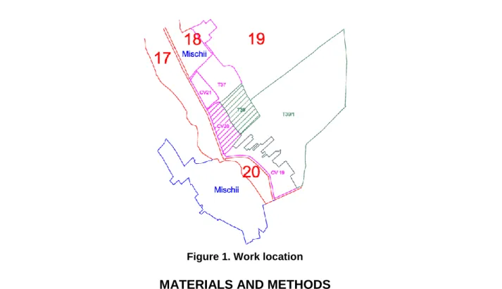
To delimit the area of interest was taken administrative-territorial limit of Mischii from Dolj Cadastre and Land Registration Office. It was necessary to identify and establish territorial-administrative boundaries of communes neighboring village Mischii respectively Murgasi, Simnicu de Sus and Gherceşti commune from Dolj County and Vulpeni commune in Olt County. Boundary delimitation work will be done in compliance with technical standards for the introduction of general survey approved by Order no. 534 of 01.10.2001 of the Ministry of Public Administration published in Official Gazette no. 744 of 21.11.2001.
After the measurements, revealed the existence of differences in the cadastre works sporadically (construction demolition, new construction raised, limit changes). For each property were collected simultaneously all data relating to constructions (number of floors, structure, building year, etc..).
By conducting surveying work in ground and identifying buildings boundaries were drawn cadastral sectors boundaries wich have been incorporated into the overall cadastral plan of the Mischii commune, plan to scale 1:10000. Any corrections to the UAT limit is done only with prior approval of Dolj Cadastre and Land Registration Office. The boundaries defining cadastral sectors will not intersect the limits of the property.
65
Figure 1. Work location
MATERIALS AND METHODS
In carry out the activities of surveying for establishing properties limits was achieved a thickening and rising network of commune Mischii using GPS technology coupled with the total station measurements. For the same purpose were determined by new methods (ROMPOS) a series of points, the accuracy is reflected in the precision class specific to these types of papers.
Given that there are no plans at 1:2000 scale for the whole area of UAT Mischii was chosen GPS measurements method combined with classical measurements.
In the design work and recognition of land was intended that the points that will be included in the network, to comply a number of suitability criteria for determinations in GPS networks: points materialization to ensure stability and preservation in time, points not be marked with metal pyramids and bridges to dispose of open horizon; convenient access to points, the points position do not raise problems in their use, anytime, by any user or because the landowner on which they are located.
Given the particularities of area of UAT Mischii was necessary planting 12 new topographical points, evidenced by concrete landmarks located in six distinct areas within the UAT, which will be used both in intravilan and extravilan topographic measurements, the proportion being 60% intravilan, 40% extravilan.
For extravilan were used only 40% of new points because there are other points that are part of the national geodetic system in the UAT Mischii area, that can be used in measurements such as Drumul Batut, Ungurenii Mici, Calineşti, Tabaci Vest, but also due to the use of RTK / ROMPOS technology for measurements in UAT's area. Were used the following methods: static / rapid-static and ROMPOS-RTK.
66
RESULTS AND DISCUSSION
Following the identification of land have been measured the extravillan and intravilan of Mischii Commune. To determine the fields limits was needed measures of all elements as: exploitation roads, county roads, woods, creek Tesla, channels.
National geodetic network existing in the area was made up of two fourth-order geodetic points namely: geodetic point " Motoci Pyramid " located in the trapeze K-34-132-D-c (UAT Mischii); geodetic point "Gherceşti-Ungurenii Mici” located in the trapeze L-34-132-D-d (UAT Gherceşti). Likewise detail measurements made with conventional technology (electro-optic) was performed taking into account the principle of redundancy (multiple measurements than is strictly necessary), so position determining in RTK mode included two coordinate measurements in each point of detail (similar to the method of double radiation) by performing two initialization of the observations at short intervals of time (seconds, minutes).
Recording times are 5 seconds for both permanent station and new points materialized by concrete landmarkes. Based on data collected were drawn parcel plans. Within the GPS network were determined absolute coordinates of 42 new points, which were materialized by planting of 42 landmarks in the field (table 1, figure 2)
Table1
Coordinate inventory of determined landmarks
Landmark no.
Rectangular coordinates Altitude (Z)
X Y
B1 322718.247 407905.368 179.678 B2 323451.908 407822.913 176.839 B3 321139.983 409341.547 171.602 B4 320947.136 409169.512 171.739 B5 319275.502 410937.593 168.172 B6 319609.139 411299.618 170.646 B7 326688.842 408010.299 208.257 B8 327263.179 408682.666 221.775 B9 328519.002 410908.056 181.571 B10 328633.312 410930.291 207.029 B11 324243.134 409491.915 214.695 B12 324040.870 408768.257 215.208
.... ... ... ...
67
Figure 2. Support and raising network Figure 3. Traverses identification
To make measurements for buildings from square 20, within the built-up areas of Mischii commune and 39 field from outside the built-up areas of Mischii were executed two supported traverses.
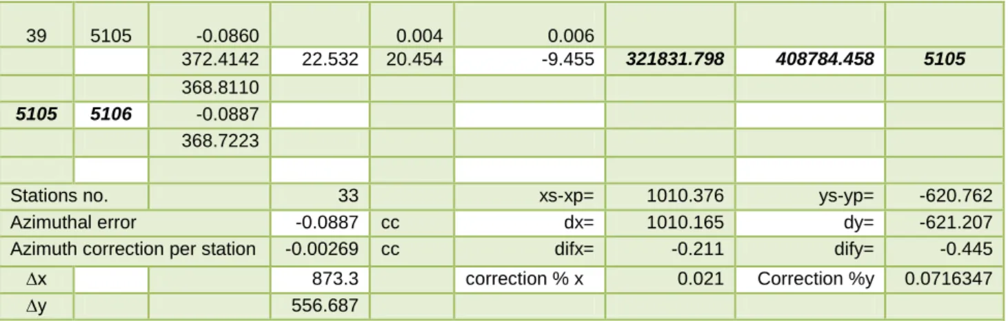
For the first traverse were gone from GPS V001 landmark, oriented on GPS V002 landmark and were closed on 5105 landmark with orientation on 5106 landmark, traverse from which were obtained the following points of station: 1, 2, 3, 4, 6, 8, 9, 10, 11, 12, 13, 14, 15, 17, 19, 20, 21, 22, 23, 24, 25, 26, 28, 30, 31, 32, 33, 34, 36, 38, 39 (Table 2, Figure 3, Figure 4).
Table 2
Calculation of the traverse from V001 landmark to 5105 landmark
Station
Target point
Orientation g.c.cc.
Distance (m)
Relative coordinates Absolute coordinates Pt.
∆x ∆y X Y
138.0462
V001 V002
320821.422 409405.220 V001
388.8322 204.804 -36.31 1 -0.0027 0.042 0.026 388.8295 207.998 204.846 -36.284 321026.268 409368.936 1 387.9580 96.128 -18.412
1 2 -0.0054 0.02 0.013
387.9526 97.876 96.148 -18.399 321122.416 409350.537 2 384.6518 87.419 -21.506 2 3 -0.0081 0.018 0.015 384.6437 90.026 87.437 -21.491 321209.853 409329.046 3
68
From the station points 4, 15, 26, 28, 33, 34, obtained by the above mentioned traverse were calculated following radiated stations 5, 7, 16, 27, 29, 35, 37.
For the second supported traverse was departed from station 17 oriented on station 15 (stations obtained from first traverse) and was closed on 5105 landmark, oriented on 5106 landmark, after which traverse were obtained following points of station: 18, 41 42, 43 (Table 3, Figure 3, Figure 4).
Table 3
Calculation of the traverse from point 17 to 5105 landmark
Statio n Target point Orientati on g.c.cc. Dist. (m)
Relative coordinates Absolute coordinates Point
∆x ∆y X Y
103.1669
17 15
321452.41
3
408932.394 17
50.8323 207.484 212.951
18 -0.0045 -0.253 0.091
50.8278 297.318 207.231 213.042 321659.64 4
409145.436 18
14.6828 139.201 32.666
... ... ... ... ... ... ... ... ...
43 5105 -0.0227 -0.025 0.003
180.0732 22.561 -21.49 6.95 321831.79 8
408784.458 5105
368.7496
5105 5106 -0.0273
368.7223
Stations no. 6 xs-xp= 379.385 ys-yp= -147.94
Azimuthal error -0.0273 cc dx= 380.158 dy= -148.21
Azimuth correction per station
-0.00455 cc difx= 0.773 dify= -0.278
dx 634.622 Correction
% x
-0.1218048 Correction %y
0.0425
dy 653.342
For station points obtained from the above mentioned traverses was drawn support network and surveying scheme (Figure 4). From measurements on the field and detail points calculation (Table 4) was drawn site and boundary plan for properties from 20 quad
39 5105 -0.0860 0.004 0.006
372.4142 22.532 20.454 -9.455 321831.798 408784.458 5105
368.8110
5105 5106 -0.0887
368.7223
Stations no. 33 xs-xp= 1010.376 ys-yp= -620.762
Azimuthal error -0.0887 cc dx= 1010.165 dy= -621.207
Azimuth correction per station -0.00269 cc difx= -0.211 dify= -0.445
∆x 873.3 correction % x 0.021 Correction %y 0.0716347
69
built-up area and for the properties outside of the built-up area – 39 field (parcel plan) of Mischii village, Dolj County.
Figure 4. Drawing of the support network
Table 4
Inventory of coordinates
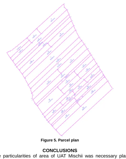
Parcel plan (Figure 5) consists of all existing parcels of unincorporated area from 39 field Mischii, their surfaces, according to land ownership and correspond to the reality on the ground, being drawn at the scale 1:1000.
Point no.
Absolute coordinates
X Y
50 321770.387 408832.045 51 321771.074 408832.889 52 321768.065 408833.918 53 321768.783 408834.789
... … …
70
Figure 5. Parcel plan
CONCLUSIONS
Given the particularities of area of UAT Mischii was necessary planting 12 new topographical points, evidenced by concrete landmarks located in six distinct areas within the UAT. Points of surveying network have a description and a set of coordinated in European Terrestrial Reference System ETRS89 and national SRC (Stereographic 1970). At the OCPI level will be made database to include these items. Points of surveying network will be used in the future surveying works or to any inspections or audits.
BIBLIOGRAPHY
1. Gânj G., 2009 - Drept privat și proiecte personale-Cartea funciară, Iași,
http://www.ganj.ro/uploads/Publicatii/cartea%20funciara.pdf.
2. Mihăilă M. şi colab.,1995 - Cadastru general şi publicitate imobiliară, Editura Ceres, Bucureşti.
3. Neuner J., 2000 - Sisteme de poziţionare globală, Editura Matrix Rom, Bucureşti. 4. Păunescu C., 2004 - Curs de geodezie – topografie, vol. III, Editura Universităţii din Bucureşti.
5. Tamaioaga Ghe., Tamaioaga D., 2005- Cadastrul general și cadastrele de specialitate, Editura Matrix Rom, Bucureşti.
6. *** Ordinul Ministerului Administraţiei Publice nr. 534/2001, publicat în Monitorul