COMMONWEALTH OF MASSACHUSETTS
MASSACHUSETTS OUTDOORS 2006
STATEWIDE COMPREHENSIVE OUTDOOR RECREATION PLAN
Deval L. Patrick, Governor
Ian A. Bowles, Secretary
COMMONWEALTH OF MASSACHUSETTS
STATEWIDE COMPREHENSIVE OUTDOOR RECREATION PLAN
MASSACHUSETTS OUTDOORS 2006
TABLE OF CONTENTS
Chapter 1. INTRODUCTION to MASSACHUSETTS OUTDOORS 2006 4
Chapter 2. OPEN SPACE AND RECREATION SUPPLY 12
Ownership and Management of Open Space Lands...12
Updating the SCORP Inventory ...16
Access for People with Disabilities ...21
Chapter 3. DEMAND 22 Summary of General Population Survey Methodology ...22
Demand for Recreational Areas ...23
Demographic Differences...34
Support for Future Investments ...38
Regional Demand Patterns ...38
Municipal Open Space and Recreation Plans...Error! Bookmark not defined. From Assessing Demand to Filling Need...47
Chapter 4. NEEDS ASSESSMENT 48 Statewide Unmet Need for Recreation Facilities...48
Inferred Need for Resource Areas...52
Funding Preferences ...53
Drawing Conclusions ...56
Chapter 5: THE REGIONAL PERSPECTIVE 57 The SCORP Planning Regions...57
Berkshire Region...58
Connecticut Valley Region...64
Central Region...71
Northeastern Region...78
Metropolitan Boston Region ...86
Southeastern Region...93
Cape Cod and Islands Region ...101
Chapter 6. SUBCOMMITTEE POLICY REPORTS 109 Subcommittee on Public Recreation in Natural and Sensitive Areas ...109
Subcommittee on Water Resources...111
Subcommittee on Urban Conservation and Public Recreation...113
Subcommittee on Cultural and Historic Resources ...115
Subcommittee on Wetlands...117
Chapter 7. POLICIES AND RECOMMENDATIONS 120 Chapter 8. CONCLUSION 138 Resources and References: State and Federal Contact List 139 COMMONWEALTH OF MASSACHUSETTS...139
FEDERAL AGENCIES ...142
Acknowledgements 143
Appendix A: Summary of Natural Resource Policy Documents Completed Since 2000 145
Chapter 1. INTRODUCTION to MASSACHUSETTS OUTDOORS 2006
What is SCORP?
The Statewide Comprehensive Outdoor Recreation Plan (SCORP), Massachusetts Outdoors 2006 is an update of the SCORP 2000, five-year plan. SCORP plans are developed by individual states to be eligible for federal Land and Water Conservation Fund (LWCF) grants. Since it was first required in 1960, the SCORP has also become an invaluable tool for states to use in planning for future needs and uses of outdoor resources for public recreation and relaxation.
MASSACHUSETTS LAND & WATER CONSERVATION FUND PROGRAM
The Land and Water Conservation Fund Act was authorized in 1965 (P.L. 88-578, 16 U.S.C. 4601-4-4601-11) and extended in 1987 through FY 2015 (P.L. 100-203). The Act established a funding source for both Federal acquisition of park and recreation lands and matching grants to state and local governments for recreation planning, acquisition and development. It set requirements for state planning and provided a formula for allocating annual LWCF appropriations to the States and Territories. For local communities trying to provide quality recreational areas close to home, the LWCF stateside program is a key tool. Demand for support of worthwhile, eligible projects here, and across the country, has far exceeded available funds. The LWCF stateside program is an effective and efficient mechanism to reclaim a small portion of the limited open space that remains, and to renovate recreational facilities that are seriously overused.
In Massachusetts, the LWCF program is administered through the Executive Office of Energy and Environmental Affairs (renamed from Executive Office of Environmental Affairs, or EOEA, in 2007). The Secretary of Energy and Environmental Affairs is appointed by the Governor to act as the State Liaison Officer for the grant program, and the Director of EEA’s Division of Conservation Services is the Alternate State Liaison Officer. Liaison officers are authorized to represent and act for the state when dealing with the Director of the National Park Service on LWCF matters, and have the authority and responsibility to accept and administer funds paid for NPS approved LWCF projects.
Funds can be used by eligible state agencies such as the Department of Recreation and Conservation and the Department of Fish and Game, as well as cities and towns for public conservation and recreation projects. Eligible projects include the acquisition of conservation and recreation land, renovation of existing outdoor recreation areas, or development of new facilities. Massachusetts has received $94.4 million since 1965. Land acquired or developed with these funds become protected under the
Massachusetts Constitution (Article 97) and federal regulations – and cannot be converted from intended use without permission from the National Park Service and EEA. A converted site must be replaced with land of equal value not already in recreational use, and of equal utility to the converted site. Conversion proposals must also be approved by the National Park Service, through EEA. All sites must be open to the general public and legally dedicated to public conservation or recreational use.
The stateside program has been used successfully to aid in acquisition of conservation projects such as hunting and fishing sites, heritage corridors, greenways and riverways as well as funding the development of outdoor recreation facilities. The LWCF program makes an important contribution to the protection of wildlife habitat, water quality, farmlands, and archaeological sites as well as providing a quality outdoor
areas in the Blackstone River Valley National Heritage Corridor, and the historic Paine Estate in Wayland. The impact of these protected conservation and recreation areas can be evaluated in human as well as environmental terms. LWCF projects play an important role in improving the quality of life in many communities by providing access to sites that are close to home and can be enjoyed regardless of mental or physical disability. Inner city residents acknowledge that park and recreation areas offer a positive alternative to crime and gang violence. They also help people to learn to appreciate the value of protecting natural resources, since positive results can be seen in one's own neighborhood.
The LWCF program was purposefully designed to ensure that the local project sponsor (a municipality or state agency) makes a clear commitment to the project. The program only pays up to 50 percent of the total project cost, and many projects have required the local sponsor and neighboring private interests to invest much more than 50 percent. For example, it was estimated that the Lechmere Canal project in Cambridge leveraged ten private dollars for every single public dollar spent. Furthermore, maintenance costs are solely the responsibility of the local sponsors, and future grants are withheld if grantees cannot demonstrate an ability to care for the federally assisted sites they already have. This is a cost-effective partnership program that is making a big difference with very limited funds.
How was the SCORP Developed?
For the SCORP 2006 update, we have updated all the critical open space maps and data listed in this document. We also include new information on data collection, studies and analysis done since SCORP 2000. For example, we have found the municipal Open Space and Recreation Plans to be a crucial resource for gauging open space planning trends, and for obtaining public input.
Due to the comprehensive nature of the work that was done while developing the 2000 SCORP, most of that work remains in this 2006 document. Work on the 2000 SCORP Report began when the SCORP Technical Advisory Committee (TAC) was established. Committee members included numerous state and municipal employees, recreation professionals, representatives of public interest groups, conservation commission members, and other interested parties. The TAC first developed a series of plan objectives for the SCORP 2000. These objectives were to:
• provide reliable data on recreation resource availability and utilization;
• measure public perceptions of, desires for, and satisfaction with existing recreation resources;
• assess the capabilities of state and local agencies to sustain and or expand the current level of outdoor recreation opportunities;
• define and analyze, based upon the above data, the current and future critical outdoor recreation issues in Massachusetts;
• develop, evaluate, and select policies and actions designed to address the defined issues;
• prioritize policy decisions that optimize the efficient and effective use of resources available to the Commonwealth; and
• continue state and municipal eligibility in the federal Land and Water Conservation Fund program.
The TAC then created six core subcommittees based on specific outdoor recreation resources: Public Recreation in Natural and Sensitive Areas, Greenways and Trails, Water Resources, Urban Conservation and Public Recreation, Cultural and Historic Resources, and Wetlands. These subcommittees were directed by the TAC to identify key recreation issues and develop recommendations for their future use and protection.
To assist these subcommittees in their work, the Massachusetts Geographic Information System office (MassGIS) began to implement an aggressive inventory of all open space and recreation areas in the state
to open space mapping and analysis. This has facilitated continued updates of the open space data layer including new acquisitions done by state, federal, municipal and land trust organizations. An intensive effort has also been put towards mapping of the 3,000 permanent, non-state conservation easements in the state which have been approved by the Secretary of Environmental Affairs as required by state law. The open space maps and data, funded in part through the SCORP project, are available to municipalities and other users and are accessible to the general public via the Internet.
How was the Demand Surveyed?
A third component of the SCORP project was a demand survey to measure public interest in and
preference for outdoor recreation resources, activities and issues. A demand survey was developed by the SCORP TAC and refined and conducted by Chadwick, Martin, and Bailey, Inc., an independent research firm.
This survey provided important data for use by the TAC subcommittees and it is hoped this information will be utilized by government entities at all levels when developing public policy on outdoor recreation. More recently, EEA completed a detailed review of 160 Open Space and Recreation Plans completed since 2001. One of the purposes of this extensive effort was to gain additional information on demand for open space and recreation facilities in these communities (26 cities and 134 towns).
Methodology of 2006 and 2000 versus Previous Plans
An historical hurdle for SCORP reports has been the presentation of data in a way that is useful to policy makers and program managers involved in conservation and outdoor recreation. Formulas designed to integrate inventories on recreation sites, survey results on public perceptions of outdoor recreation, and policy recommendations have tended to be overly prescriptive and difficult to interpret. For this report, data on outdoor recreation sites and data on perceived outdoor recreation needs, as identified through the statewide survey provided in Section III, are provided to help shape policy recommendations at the local, regional and statewide levels. This statewide plan provides the policy recommendations for the state as a whole, and suggests key issues at regional levels that should be incorporated into those regional plans. The local plan policies are not presumed here, but should reflect consistency with the policies and data this SCORP provides. This plan provides the larger geographical context for the local plans.
As a further word on integration of planning at differing geographical and governmental levels, the statewide SCORP reports have been very much that - i.e. oriented to the particular state without substantial reference to the wider geographical context for the state – in our case the New England or northeastern U.S. region. This inherent tendency of state plans is not fully addressed in this update, but is noted for consideration in the formulation of future plans, and as a reminder to the reader to put the information provided here in its New England context. By way of illustration, the survey data is collected specifically and only for visitations to facilities in Massachusetts. Hence, the degree to which those who seek experiences such as mountain hiking, down hill and cross-country skiing, wilderness canoeing, etc. in the northern New England states is not represented here. Conversely, since the survey was directed only to residents of Massachusetts, the visitation of this state’s hallmark cultural, historical and coastal sites by out-of-state visitors is also not reflected in the demand and needs data. This point will be reiterated in appropriate locations throughout this plan as a caution in interpreting the data provided.
Public Input for the 2006 Update
The following is a summary of the Public Input Component of Massachusetts Outdoors 2006.
1. The Statewide Land Conservation Plan Developing the Plan
In the spring of 2001, EEA land staff teamed up with nonprofit and government partners to develop a statewide land conservation plan that would set clear land protection goals and guide the land
conservation efforts of all partners. It was clear that only by working together could we hope to leave a legacy of conservation that preserves the valuable natural resources, community character and quality of
natural resource agencies, and regional planning agencies collaborated to identify the highest priority open space areas needed to protect a connected network of the most important water resources, biodiversity habitats, working farms and forests, urban parks, and outdoor recreation areas.
The Task Force was supported by extensive work from MassGIS staff. More than 30 science-based plans and resource-related maps were digitized and overlaid. The Task Force agreed on a method that required three or more maps to coincide on a specific area in order for that resource to be considered of statewide or regional significance (and therefore, to be included in the Plan). The process of creating the map was further guided by a review of 30 municipal open space plans representing the most innovative land conservation plans for urban, suburban and rural communities. Finally, the Plan received in-depth input from municipal officials, recreational user groups and the general public at five public meetings held across the state. In 2003, an additional three meetings were held with 25 state and land trust staff to develop an implementation strategy for the plan.
2. Commonwealth Connections: A Greenway Vision for Massachusetts
DCR, which owns and manages many greenways and trails in the state and works with private groups on many others, teamed up with the Appalachian Mountain Club, the nation’s oldest conservation and outdoor recreation organization, and the National Park Service to lead the effort. Most of the information for this project was gathered through a series of interactive workshops, questionnaires and interviews involving hundreds of planners, land managers, grassroots activities, greenway and trail users, non-profit
organizations, state and federal agencies and interested citizens. Participants were asked to share their knowledge of existing greenways and trails, to identify critical corridors for conservation and recreation and to work together to develop a broad vision for each region and ultimately for the state. Based on this detailed input and later analysis, DCR and its partners developed a set of recommendations that reflect the major themes and priorities heard across Massachusetts.
3. Urban Open Space Assessment Project
This project is designed to assist community groups in identifying ecologically valuable, socially important sites in urban areas and determining a transformation or preservation strategy for those sites. This project included 24 meetings with stakeholders and interested citizens in Worcester, Lawrence and Holyoke. The meetings also included five focus group meetings. The project also included surveys. The project also included initial literature reviews to make sure that information that had already been collected was used. The project continues to be completed for Fall River and Somerville with private foundation funding and additional meetings are being held there.
4. A Summary of the 2005 Urban Land Protection Forum
To address urban land conservation in Massachusetts, a small group of urban land trusts and urban conservation and land-use professionals have been meeting semi-regularly since 2004 to network, share project successes and stumbling blocks, and address common misperceptions about urban land protection. The first gathering, Improving Life in your City or Town: Land Conservation on a Neighborhood Scale, was a day-long conference that took place in Lowell, MA, in September 2004 with former MA Governor and Presidential Candidate Michael Dukakis as the keynote speaker. With, more than 100 participants, this conference highlighted the uniqueness of urban land conservation work, the importance of sharing information within the state, and the sheer diversity of entities concerned about urban land conservation. The entities represented at this conference weren’t just land trusts—participants came from state and federal agencies, municipalities, community development corporations, garden clubs, trail groups, neighborhood associations, watershed associations, environmental justice organizations, and more. A few months later, participants from the Massachusetts Executive Office of Environmental Affairs saw the need to follow-up on ideas and concerns expressed at the 2004 Lowell conference. EOEA gathered the
5. 160 Municipal Open Space and Recreation Plans
States must maintain a current Statewide Comprehensive Outdoor Recreation Plan to qualify for federal Land and Water Conservation Funds. Similarly, communities in Massachusetts are required to prepare a municipal Open Space and Recreation Plan, also approved for a five-year period, to maintain eligibility for state Self-Help, Urban Self-Help, or federal Land and Water Conservation Fund assistance. Currently there are 160 approved plans, making 46% of the state’s communities eligible for these discretionary funds through the Division of Conservation Services (DCS).
All DCS grants are partnerships between state and local agencies and are based on recommendations the applicant community makes independently in its Open Space and Recreation Plan prepared by volunteer groups or by consultants with help from DCS. While DCS approved plans are an eligibility requirement for participation in the grant programs, communities often prepare these plans regardless of the availability of grant assistance.
The factors that affect open space are identified and examined during the planning process, and strategies the community may use to protect and enjoy its character, natural resources and open spaces are developed. Protecting open space can provide profound economic benefits by helping to avoid the costly mistakes of misusing or overwhelming available resources. An open space and recreation plan is a blueprint for how to obtain the benefits of development without losing valued environmental assets. Open Space Planning Requirements, a companion workbook, and technical assistance are available from DCS. Open Space and Recreation Plans are not valid until they are approved by DCS.
Public participation is also required for the municipal plans, although each community may decide exactly how they obtain this input. Public participation lies at the heart of any planning effort. If a plan is to truly represent the range of views and hopes of the community, the public must be actively involved in
developing it. Some of the techniques used on these plans include public meetings and forums, surveys, visioning sessions, working group meetings, and effective use of the media for education and outreach. Some of the better plans use a variety of these techniques, and some are combined within a single event (e.g., working-groups as a component of a public forum, covered by the local paper). Of the 160 plans currently on file at DCS, the public input statistics are impressive:
o 70%, or 112 planning projects, were compiled using some form of Open Space Planning Committee;
o 223 public meetings were held; and o 55,516 individuals responded to surveys.
Focus on Major Issues
The SCORP survey, open space and recreation inventory, and TAC policy reports were organized around general categories of natural resources, such as greenways and trails and water resources. From a review of the survey and inventory data and the policy discussions, issues emerged that were common to all of the resource categories. Consequently, these issues have been used as the framework for the recommendations of this report. The six major issues identified in the SCORP 2000 were: Resource Protection; Planning and Enhancement; Education and Information; Partnerships; Funding; Access and Maintenance.
1. Resource Protection, Stewardship, Restoration and Enhancement
At the heart of both active and passive outdoor recreation is an enjoyment of natural resources: clean air, clean water, healthy wildlife, flourishing habitats and vegetation, and scenic vistas. Quality outdoor recreation experiences are dependent on the protection, sound stewardship, restoration and enhancement of these resources, and, in areas where intense urbanization has displaced the natural environment,
reclamation of vacant sites and creative greenway and playground development are needed.
2. Education and Information
Public information and education play a pivotal role in outdoor recreation and must be expanded and tailored to encompass a wide variety of age groups, learning abilities and special needs. Informing the
areas, and communicating the health benefits provided by outdoor recreation, all help to ensure the public's long-term enjoyment of, and support for, outdoor recreation.
3. Partnerships
In today's changing budgetary environment, solutions to all of these SCORP issues can only be realized through creative approaches to programming and protection of recreation resources. Partnership opportunities should be extended to as many partners as possible including both public and private organizations and individuals.
4. Funding
Resolving most of these SCORP issues depends upon two additional factors: the creativity and vision of the people who devote their professional or personal time to improving and expanding outdoor recreation opportunities, and, equally important, funding. In both the public and private nonprofit sectors, local support for outdoor recreation is essential to ensuring sufficient government funding and charitable donations.
5. Access
Outdoor recreation opportunities need to be accessible to all residents regardless of race, color, physical or mental challenges, place of residence, or age. Barriers to use of outdoor resources for recreation and relaxation, including lack of public transportation, physical impediments, and inappropriate or out-dated infrastructure, are all issues that need to be addressed in developing or improving outdoor recreation sites.
6. Maintenance
To accommodate public need, recreation sites, trails, facilities, beaches, and playgrounds must be well maintained and appropriately staffed on a regular, continuous basis. Failure to do so, even for short-term reasons, can have long-term implications, decrease public safety and support, and adversely impact public recreation experiences. Commitment by the federal, state, and local governments to maintenance of outdoor recreation areas is critical, but creative ways to ensure proper maintenance levels must also be explored, including adopt-a-trail, adopt-a-park, and other public-private partnerships.
In addition to these original six issues, the following three were added for the 2006 update
1. Urban Focus on Resource Protection, Stewardship and Restoration and Enhancement
Improve the quality of life in our 51 cities by providing new parks and renovating parks in poor repair, especially in neighborhoods under-served for parks and with a high percentage of young residents.
2. Innovate Tools for Land Protection
Create innovate tools to meet long-range land conservation goals included in the Statewide Land Conservation Plan.
3. Long Distance Trail Protection, Development and Issue Resolution
About This Report
The SCORP 2006 is organized into eight sections:
Chapter 1. Introduction to Massachusetts Outdoors 2006; Chapter 2. Open Space and Recreation Supply;
Chapter 3. Demand;
Chapter 4. Needs Assessment; Chapter 5. The Regional Perspective; Chapter 6. Subcommittee Policy Reports; Chapter 7. Policies and Recommendations; and Chapter 8. Conclusion.
The SCORP report has traditionally been divided into a series of planning regions to make the report more meaningful and useful to the reader. To maintain continuity with previous plans, the SCORP 2006 uses the seven-region model presented in the 2000 and 1988 SCORP. The boundaries of these seven regions generally correspond to county boundaries and are closely related to the planning regions that are used by other resource planning agencies. Recreation demand and needs findings are organized around this seven region model.
Figure 1. 2006 SCORP Planning Regions
Central Southeastern Connecticut Valley Northeastern Berkshires Metropolitan Boston Cape Cod and Islands SCORP Regions
Outdoor Recreation Planning and Conservation Planning
This report primarily focuses on outdoor activities that take place on dedicated recreation resources (open space resources) such as parks, forests, beaches and trails. This report does not address outdoor recreation issues as they relate to predominantly built environments, such as bicycling on state roadways, though such areas can be and are significant resources for outdoor activities. State and local governments, highway and public works departments and planning agencies should consider the potential offered by roadways, plazas and other built areas for quality outdoor recreation experiences.
The major theme or issue of Resource Protection, Stewardship, Restoration and Enhancement referred to on the previous page acknowledges that outdoor recreation depends heavily on the quality of the
environment for its satisfaction. Indeed, several activities surveyed and reported in the following sections – e.g. walking, photography, hiking, hunting, fishing, camping - are greatly influenced not only by the general attractiveness of the environment, but as much by the health of the wildlife and plant communities encountered. In these pursuits, there is a true and evident intersection of human recreation and
However, it would be presumptuous to term this outdoor recreation plan as being synonymous with comprehensive open space issues whose ecosystem concerns go well beyond the scope of the survey of Massachusetts residents and an inventory of facilities. Open space advocates and environmental agencies such as the Massachusetts Executive Office of Energy and Environmental Affairs look forward to a time when such integration of comprehensive planning will occur.
For the present, however, we must look instead for the consistency of this SCORP, and actions which flow out of it, with other existing open space documents having either a specific conservation objective or a more comprehensive open space focus. Several such reports and studies have recently been released specific to Massachusetts, including:
• The Statewide Land Conservation Plan, Executive Office of Environmental Affairs, 2003.
• BioMap: Guiding Land Conservation for Biodiversity in Massachusetts, Mass. Div. of Fisheries and Wildlife, Natural Heritage and Endangered Species Program, 2001.
• Massachusetts Natural Heritage Atlas: 12th Edition, Mass. Div. of Fisheries and Wildlife, Natural Heritage and Endangered Species Program, October, 2006.
• Living Waters: Guiding the Protection of Freshwater Biodiversity in Massachusetts, Mass. Div. of Fisheries and Wildlife, Natural Heritage and Endangered Species Program, 2003.
• Massachusetts Wildlife Habitat Protection Guidance for Inland Wetlands, Department of Environmental Protection, March 2006.
• Comprehensive Conservation Wildlife Strategy, Mass. Div. of Fisheries and Wildlife, July 2006.
• Commonwealth Connections: A Greenway Vision for Massachusetts, The Department of
Conservation and Recreation, the Appalachian Mountain Club and the National Park Service, July, 2002
• Urban Open Space Assessment Project, The Trust for Public Land and the Urban Ecology Institute, July, 2006
• A Summary of the 2005 Urban Land Protection Forum, EOEA, Boston University, Greater Worcester Land Trust, Lowell Parks and Conservation Trust, The Trustees of Reservations, The Trust for Public Land and the Urban Ecology Institute, November, 2006.
We seek in this report, and we encourage users of this report, to look to these additional planning documents for guidance and to balance recreation and conservation interests. We hope you will find this report a useful and valuable tool in your planning efforts and that the recommendations presented will be carefully considered when developing local and regional policies. We welcome your comments and suggestions regarding this report. Please direct all comments to the Executive Office of Energy and Environmental Affairs, Division of Conservation Services at (617) 626-1015.
Chapter 2. OPEN SPACE AND RECREATION SUPPLY
Massachusetts is fortunate to have a rich variety and abundance of natural splendor and related recreation amenities. From Race Point on Provincetown to the top of Mount Greylock in the Berkshires, residents and visitors alike can find opportunities for most any pursuit they can think of - from skiing and skating in the winter, to sailing and swimming in the summer, to hiking and hunting in the fall. Recreation
opportunities abound in rural, suburban and urban settings. In many cases, open spaces such as greenways, bikeways, long distance trails, and river corridors help connect these settings, creating a continuum of landscapes and built environments that introduce residents and visitors to different aspects of the
Commonwealth's land, people and industry. This section summarizes the recreation opportunities available in Massachusetts.
Massachusetts has been a leader in the open space arena, both in the public and private sectors. With 160 land trusts, the state has the second largest number of private land trusts in the nation. Together with the public agencies, the inventories reveal that current recreation and protected conservation resources in Massachusetts account for over 20% of the land area of the state.
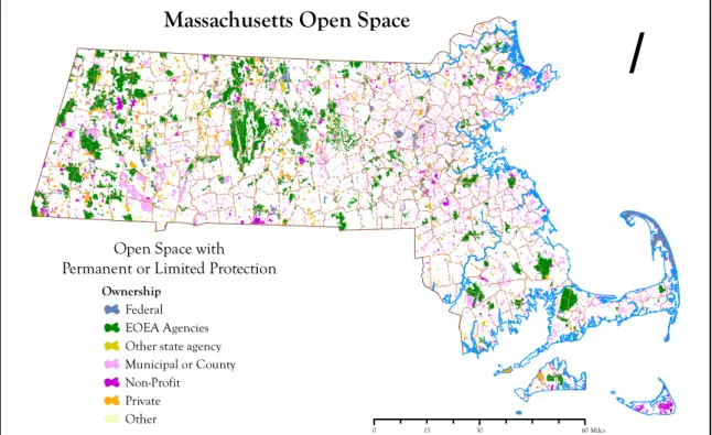
Ownership and Management of Open Space Lands
/
Massachusetts Open Space
0 15 30 60Miles
Open Space with Permanent or Limited Protection
Ownership
Federal EOEA Agencies Other state agency Municipal or County Non-Profit Private Other July, 2006
Figure 2. Massachusetts Open Space Shown by Type of Owner State Agencies
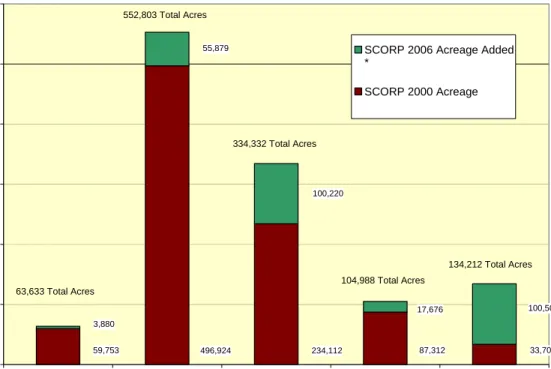
State Agencies are the principal landowners, responsible for over 550,000 acres. These sites tend to be quite large as indicated by the relatively small number of sites owned by state agencies. Municipalities are the second largest landowners but own the greatest number of sites (over 15,000). Private nonprofit and for profit owners are also important recreation landowners.
Figure 3. Major Open Space Land Owners by Acres 496,924 59,753 234,112 87,312 33,703 55,879 100,220 17,676 100,509 3,880 0 100,000 200,000 300,000 400,000 500,000 600,000
Federal State Municipal Private Nonprofit Private for Profit
Ownership
A
c
reage
SCORP 2006 Acreage Added * SCORP 2000 Acreage 63,633 Total Acres 552,803 Total Acres 334,332 Total Acres 104,988 Total Acres 134,212 Total Acres
The larger state forests include October Mountain at 16,127 acres, Myles Standish at 14,700 acres, and Mt. Greylock State Reservation at 12,500 acres. The state’s environmental agencies within the Executive Office of Energy and Environmental Affairs (EEA) control most of the Commonwealth’s open space resources. EOEA agencies include the Department of Conservation and Recreation (DCR), which manages state parks, beaches, forests; and regional water supplies in the central part of the state that serve the metropolitan area; and the Department of Fish and Game (DFG), which oversees marine resources as well as terrestrial wildlife management areas. A full range of recreation activities, both passive and active, are provided by these two agencies. DFG sites are generally open to the public free of charge, although income is generated through hunting and fishing licenses to support further land acquisition.
In addition, the EOEA includes three land protection programs that are dedicated to assisting less-than-fee or non-state ownership of resources. Two are administered through the Department of Agricultural Resources (DAR), which protects agricultural and soil resources, and the scenic and economic (food production) resources associated with farming; and the third through the Division of Conservation Services (DCS), which administers EOEA’s approval of non-state funded Conservation Restrictions (easements), and grants conservation and recreation funds (both state and federal) to the cities and towns through their parks and conservation commissions. Both DAR and DCS programs operate on a competitive application basis.
Municipalities
Municipalities are the second largest landowners in the state, but own the greatest number of sites, over 15,000. Total acreage under municipal ownership reflects both the infusion of state and federal funds and the growth in importance of the conservation commissions created by the state legislation in 1957. The commissions’ main goal is resource conservation, and they are usually responsible for managing municipal conservation land. In addition, these commissions are the administrators of the state and local wetlands
Cape Cod Land Bank in fact institutionalizes this development for 15 towns plus the town of Marion, by requiring such committees while leaving their make-up to the towns to decide. The possibility of joint membership of some members from the conservation commissions, planning boards and recreation commissions is thus left open.
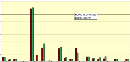
Figure 4. Major Open Space Land Owners by Number of Sites
425 2676 7321 2605 355 3086 632 8395 3372 280 0 2000 4000 6000 8000 10000 12000 14000 16000 18000
Federal State Municipal Private Nonprofit Private for Profit
Ownership
Nu
mber o
f Si
tes
SCORP 2006 # of Sites Added SCORP 2000 # of Sites
635 Total
5,977 Total
15,716 Total
3,308 Total 3,511 Total
* Please note that Figure 4. also reflects the fine tuning of MassGIS data collection since SCORP 2000. The clarified definitions of parcels and other data management categories, as well as better data collection methods, has had an impact on the numbers for 2006 versus 2000
Parks and recreation departments are major municipal land managers and are responsible for a large number of sites. School departments should also be considered, for contained within nearly every school property is some kind of outdoor recreation facility, often with unrestricted access if not legally protected open space. The acreage controlled by water departments are also significant, but often have restricted recreation access due to both real and perceived conflicts between protection of water quality and recreation use.
Private Nonprofit and For-profit Owners
Private nonprofit and for-profit owners are also important recreation landowners, although the scope of recreation activity or population served by these sites is much more limited or special purpose than the publicly owned “portfolio”. Among private nonprofit land managers, land trusts protect the greatest number of acres. The state’s three largest land trusts, Massachusetts Audubon Society, the Trustees of Reservations and The Nature Conservancy alone account for over 75,000 acres.
The type of recreation activities allowed on private nonprofit sites varies with the mission of the organization. In the case of land trusts, the primary goal is most often resource conservation, and therefore, certain types of active recreation are restricted. Opportunities for more passive pursuits, however, such as nature study, walking, and historic appreciation are abundant. Other private nonprofits
recreation opportunities. Indeed, these latter two groups of land owners, controlling nearly 12,000 acres of land largely without permanent open space protection represent one of the most important land protection opportunities in Massachusetts. As demonstrated in several recent DCR and DFG acquisitions, the sale or gift of conservation restrictions to the state or other qualified recipient, while leaving the fee ownership, use and management of the land with the private owners, can be of great benefit to both the public and these recreation oriented non-profit groups.
Private for-profit recreation resources include golf courses, campgrounds, and ski areas. Golf courses have had particularly notable growth in popularity in recent years, perhaps exceeding a similar trend in tennis during the 1980’s. Private campgrounds, although they occupy little land area and are not abundant statewide, add to the somewhat constrained supply of public campgrounds, especially in certain parts of the state. Another private recreation resource not reflected in the chart data are the private marinas, which, although they also occupy little space, are abundant and significant resources in the coastal region and on major lakes and rivers. All downhill ski areas in Massachusetts are privately operated (although several lease public land), and although they generally offer less vertical drop and fewer runs than the major northern New England resorts, they offer the great advantage of being eminently easier to reach. The expansion of night skiing and snow making capability has strengthened the niche market of these local areas.
Taken together, the for-profit recreation facilities add a much valued dimension to recreation opportunity in Massachusetts. While available on a fee basis and generally representing significant costs not available to all households, they provide a type and level of service difficult if not impossible for the public
landowners to offer. They also help to address demand, thereby reducing demand on public and non-profit facilities.
The Federal Government
The federal government owns and manages a smaller but strategic number of sites, most notably the Cape Cod National Seashore, the Parker River, Great Meadows and Oxbow National Wildlife Sanctuaries and the Cape Cod Canal, all important elements of the recreation and conservation complex of sites in Massachusetts. In addition, there are a number of small sites that also have very high visitation numbers, including the Minuteman National Park and U.S.S. Constitution.
Joint ventures with federal, state and local interests have been very successful. In Southeastern
Massachusetts, the Waquoit Bay Research Reserve and Mashpee National Wildlife Refuge in the coastal plain ponds north of Myles Standish State Forest in Plymouth are outstanding examples where several joint acquisitions have been completed since 2000. In the Connecticut Valley, conservation restrictions on 2,000 acres along the Deerfield River were achieved through the Federal Energy Regulatory Commission’s licensing of hydropower facilities. The USDA Forest Service’s Forest Legacy Program has helped the state and land trust community protect over 3,000 acres since 1995 with many acquisitions completed since 2000.
Among the federal agencies, the National Park Service (NPS) is the largest federal landholder, mainly due to their holdings in the Cape Cod National Seashore. The Department of Defense (DOD) is the second largest landholder, and although these lands have traditionally been inaccessible for recreation, they play an important role in protecting wildlife and plant habitats due to large, relatively undisturbed buffer areas that accompany defense installations. DOD sites are also important in light of recent decisions to close military installations, creating the need for military land re-use plans which could potentially include recreation use. Three active examples in Massachusetts include the former Natick Laboratories property in Sudbury and Hudson, now largely a DCR State Forest, the Oxbow National Wildlife Refuge, formerly part of Fort Devens, and, still pending, the possibility of conversion of wetland portions of the Weymouth Naval Air Station to conservation use. The extraordinary Mass. Military Reservation conversion now in
and U.S. Fish and Wildlife Service (FWS) account for the majority of the remaining federal agency holdings.
In terms of recreation use of these lands, the NPS provides the greatest number of recreation opportunities for swimming, hiking, picnicking, and boating along the National Seashore, along with providing
opportunity for historic appreciation (sightseeing, photography) and touring at their many historic sites. FWS limits recreation to protect important habitats and wildlife but still provides opportunities for walking, hiking, boating, and nature study. ACOE’s main mission is water management, but they do allow various forms of water-based recreation and biking in some areas.
Updating the SCORP Inventory
The 1988 SCORP contained a comprehensive inventory of open space and recreation facilities for the entire state. Data was collected on federal, state and local lands, providing information such as owner, location, access, and facilities for each property.
In 1993 a project to update the 1988 inventory, create a new database to store the information, and most importantly, link the new database to a geographic information system (GIS) began. This inventory is continually updated by staff at MassGIS, regional planning agencies, municipalities and other
organizations. The land resources supply data from the ongoing inventory presented here are limited in this discussion to the number of acres and sites under different ownership. However, a host of additional data, including information on public access, primary use, address, secondary interests (e.g. conservation restrictions) is available through MassGIS.
This project, the Open Space Mapping Project (OSMP), allows spatial display and analysis of both open space and outdoor recreation data through GIS, as well as improved viewing capabilities. The SCORP 2000 contributed to the development of this new open space update, database, and GIS link, and future planners should find the system a valuable tool in developing subsequent SCORP documents. Data from the Open Space Mapping Project is contained in this report. For more information on OSMP please visit the web site at http://www.mass.gov/mgis/massgis.htm.
Distribution of Recreation and Protected Land
A review of the status of protected open space shows that approximately one-fifth of the Commonwealth’s land area is protected. Note, however, that only a portion of the recreation areas listed in the chart below are permanently protected open space. Protected areas are generally all state and most federal lands (not ACE facilities, nor DOD installations), but only some municipal and private lands. Facilities or land owned by municipal school departments, boards of selectmen, fish and game clubs, Boys and Girls Scouts, golf courses, ski areas and private campgrounds and camps generally have either temporary or no
“protected” status. Without legal protection, these areas are vulnerable to a change of use, and the resources could easily be lost.
Figure 5, Acreage Held by Major Open Space Landowners 0 50,000 100,000 150,000 200,000 250,000 300,000 350,000 400,000 450,000 Nati onal Pa rk Se rvice Fede ral Wil dlife Ser vice Army Cor ps o f Eng inee rs Depa rtm ent of Def ense Dept. of C onse rvat ion & Re crea tion Dep t. of Agr icultu ral R esou rces Dept. of F isher ies & W ildlif e DCR /DFWE LE jo int Cons erva tion C omm issio ns Parks an d R ecrea tion Dep artme nts Schoo l Depa rtment s Wat er D epar tmen ts Truste es of Reserv ation s MA Aud ubo n S ocie ty Fish & G ame Club s/Sco uts/T NC /Con s. Gr ps. Land T rusts Golf Cou rses Ski Area s Camp s & Priv ate Ca mpg rou nds Ownership Ac res 2000 SCORP Data 2006 SCORP
Studying the statewide and regional distribution of the lands shown in the table below reveals conclusions that are at once both obvious and surprising. Not surprisingly the largest region, the Connecticut Region, also has the largest open space and recreation acreage. Similarly, the smallest region, the Metropolitan Boston Region, has the smallest open space acreage. A comparison by percentage, however, of the amount of open space to the size per total land area in the region reveals that the Connecticut Region ranks only fourth highest among the planning regions, while the much more urbanized Metropolitan Boston Region ranks third. This statistic becomes even more striking when you consider that the Metropolitan Boston Region contains approximately 32% of the state population but only 4.8% of the land area.
Figure 6. Open Space and Recreation Acreage by Planning Region
Planning Region Population 2000 Census Regional Land Area Open Space/ Recreation Acres % Regional Land Area in OS/Recreation Contribution to State Open Space Total % Total
MA Land Area Berkshire 143,418 597,043 193,192 32.4% 16.2% 3.9% Connecticut Valley 703,502 1,185,741 277,863 23.4% 23.3% 5.5% Central 834,160 962,131 214,369 22.3% 18.0% 4.3% Northeastern 1,471,391 762,829 164,707 21.6% 13.8% 3.3% Metropolitan 2,074,516 239,795 66,053 27.5% 5.5% 1.3%
A large percentage of protected lands occurs, as expected, in the Berkshire Region (29.5% of regional land area in open space use), yet a much higher percentage of recreation and protected lands occur on the Cape and Islands (42.1%), and the Berkshires are followed closely by the Metropolitan Boston Region, which has achieved 26.0%. The Northeastern Region ranks fifth in open space acreage and percent of regional land area in open space, while having the second highest population. As recently recognized, the Southeastern Region trails the state in percentage of land area protected or in recreation use at 14.0%, yet has the third largest population, just behind that of the Northeast at 1.1 million and growing rapidly. Recognizing this trend compelled the EOEA to embark on the Scenic and Natural Diversity (SAND) Program to dedicate a minimum of $30 million in open space funds to this region in the period of Fiscal Years 1998 through FY 2001. This funding also recognized this region and the Cape as the most rapid growth areas of the Commonwealth over the last and next 10 years. Some 7,135 acres were added to the open space inventory through this program. Many other important conservation parcels have been protected since 2001. Among the many exciting additions in the Southeastern Region are:
• Conservation and hunting areas in Mattapoisett and Rochester at the Haskell Swamp;
• The protection of the 800 acre Camp Catchalot adjacent to the Myles Standish State Forest; and
• The new 206 acre Nasketucket Bay State Park in Mattapoisett providing over 3000 linear feet of new coastal access.
• The 300 Santuit Pond acquisition in Barnstable and Mashpee – the largest remaining unprotected land on the Cape
• The permanent dedication of the 15,000 acres at the Mass. Military Reservation to conservation
• The dedication of 425 acres of prime agricultural land to permanent conservation at the state prison facility in Bridgewater
• The acquisition of 3,800 acres adjacent to state and city water supply land in Fall River to create the Southeastern Mass. Bioreserve in partnership with the state, city and The Trustees of Reservations which is planning to build a visitor center to serve the urban youth of the Fall River area on land it acquired as part of this project
• The acquisition of 28 acres with one half mile of ocean front at the former Joslin Diabetes Camp in Plymouth by the Town in partnership with DCR and the Wildlands Trust of Southeast Mass.
• The protection of 1,200 acres important for many rare species to complete the “Plymouth Challenge” project
• The acquisition of 1,600 acres in Halifax including the largest cranberry bog in the world where the restoration of this wetland area is now being planned
Since 2003, EOEA has increased its focus on protecting threatened important natural resource land in high growth areas near existing protected land. When measured by the number of people living within one mile of each acre protected, EOEA has doubled this figure over the past 4 years. Also, the “connectedness” of each acre protected (as measured by length of common boundary with existing protected land) has increased by 46% in the past 4 years. Statewide, other major additions to the inventory since the 2000 SCORP include:
• Two acquisitions in Groton – the 260 acre Gibbet Hill parcel and the 360 acre Surrenden Farm – among the most scenic parcels in central Massachusetts
• The Tully Initiative along the New Hampshire border which protected 9,000 acres in over 100 parcels via working forest conservation easements in four towns linking to thousands of acres already protected in this highly valuable natural resource area
• A conservation easement over the 135 acre Thompson Island, the last unprotected island in Boston Harbor
• The dedication of 1,500 acres in Templeton to permanent conservation at a state school for the mentally retarded
• The acquisition of 135 acres extending the Neponset River Greenway with an innovative partnership of DCR and The Trustees of Reservations that includes an endowment for future care of the land
• The acquisition of a 234 acre former ski area in Holyoke adjacent to several thousand acres of protected land on the Mt. Tom range in partnership with DCR, USFW, The Trustees of Reservations and the Holyoke Boys Club with the ski lodge now used as an outdoor center for urban youth
In addition, the Martha’s Vineyard and Nantucket Land Banks, providing dedicated local funding for open space acquisition, have been in operation throughout the period since 1988, having great effect in the islands’ efforts to meet the demands placed upon them for scenic, water-based, and historical recreation visitation. To these innovative funds the Commonwealth added legislation and matching funds to create a Cape Cod Land Bank, commencing operation July 1, 1999.
Now every community has the opportunity to create its own source of local funds using one of the most significant conservation and recreation land tools to be added in Massachusetts in recent years, the Community Preservation Act. This state law allows cities and towns to raise their local property taxes and dedicate this funding to conservation and recreation projects, affordable housing, and historic preservation projects with at least 10% required to be allocated to each area. The municipal funding is matched by a state deed transfer tax. In the past four years, the 119 municipalities that have adopted this law have spent $87.5 million on conservation projects and $15.5 million on recreation projects.
Per Capita Distribution of Recreational Areas
Clearly, the geographic distribution of recreational areas, or sites, must also be viewed in light of population distribution, and it is obvious with the concentration of population in the eastern part of the state, near the coast, that people are far less evenly distributed than are acres. The per capita acres of recreation and conservation land available within the Metropolitan Boston Region are predictably low, at .03 acres per person (or 300 acres per thousand, as some of the national recreation standards would be expressed). This region is followed by the Northeastern and Southeastern Regions, at .11 and .13 acres per capita respectively. A little more surprising, notwithstanding the presence of the state’s second largest city, Worcester, is that the large Central Region only reports .26 acres of open space per capita. Conversely, the Berkshires and Cape Cod and Islands Regions seem flush with recreational opportunity, at 1.35 and .45 acres per capita respectively, until one stops to think of the level of both in-state and out-of-state visitation these particular regions receive. Figures for the out-of-state visitors, as will be noted again, are not represented in the demand survey figures provided in the next chapters.
The discussion of these supply-side statistics and patterns in the policy and recommendation sections in subsequent chapters must grapple with the age-old dilemma of making sites accessible to people where they live, while also recognizing the value placed on wilderness experience and travel to exotic locations whose very power of attraction comes from their distance from home. Massachusetts' environmental agencies have come to know that both are critically important.
Types and Uses of Recreational Areas
Recreation takes many forms. It can be active or passive, physically challenging or psychologically soothing, an individual endeavor or a family activity. Recreation can be pursued in one’s own backyard, or in a state park miles from home. Most importantly, recreation is a diversion from the routine of every day life. It is what we do for relaxation, how we spend time with family and friends, and how we keep in touch with the natural world around us. It is as Webster’s defines it: “ a refreshment in body or mind”.
The raw number of acres in either protected or recreation use (and not always protected open space) reported in the prior section is further refined here, and expressed more specifically in terms of the number of recreation sites, and types of recreational activities represented. To render the large amount of
information produced in this SCORP a little easier to grasp, the 38 specific recreational activities documented here have been grouped into five general categories:
• wilderness.
This categorization represents a slight elaboration on the 1988 SCORP categories, where “Natural Resource Facilities” have now been broken into “Wilderness”(e.g. camping, hiking) and “Passive” (e.g. sunbathing, nature painting and photography) activities. The former “Recreation Facilities” are now “Field –Based Activities” which includes baseball, basketball, football, soccer, golf, tennis, playgrounds,
volleyball and ice skating at rinks. Collectively, all of these activities require formal and often extensive site development. The former “Transportation Activities” are now described as “Trail-Based Activities”. The five general categories of recreational activities that are available across the state are listed below. The table shows availability of these activities, whether formally or informally available. That is, activities that occur at sites that are not designated for that activity are counted. The purpose of the data is to show the activities that are actually occurring, not only those that have been designed for, and consequently this method gives an expanded estimate of activities. The total number of sites for all activities across the state is listed at the top of the table. Activities have been grouped into five categories based on the similarity of the recreational areas, or resources, on which they take place.
Figure 7. Number of Sites by Activity *
Activity
Statewide Ber
kshir
e
Connecticut Valley Central Northeastern Metropolitan Boston Southeastern Cape Code and Islands
# of Sites 10,963 488 1,283 2,526 2,526 1,956 2,107 1,326 Field-Based 9,920 516 1,554 1,379 2,041 2,217 1,580 631 Passive 8,708 525 1,009 1,024 2,066 1,241 1,552 1,291 Trail-Based 12,859 1,041 2,038 1,935 3,466 1,208 2,041 1,130 Water-Based 7,853 476 933 1,008 1,545 781 1,514 1,572 Wilderness 1,619 162 286 276 296 30 319 150 * 2000 SCORP Data
Statewide, the largest number of existing recreational areas appears to be dedicated to trail-based and field-based activities, with the number of sites for passive recreation and then water-field-based activities following relatively closely. By a long margin, however, the fewest number of sites are available for wilderness activities.
This table also illustrates that opportunities for certain field activities are significantly more abundant in one region than another. Basketball, tennis, and playground opportunities are more abundant in the urban the Metropolitan Boston Region than in the suburban and rural regions. As with field activities overall, this finding can be attributed to the relatively small area required for these facilities and the limited land area available for recreation in the metropolitan Boston area. Sightseeing and touring opportunities are most abundant in the Metropolitan Boston and Cape Regions, most likely a result of the high concentrations of recognized historic sites.
A look at regional patterns reveals some unexpected patterns. The Berkshire towns report the fewest number of total sites – perhaps because of larger size of sites and lesser population. However, even the number of wilderness and trail sites, which would be expected to be larger, is much lower than other regions.
Conversely, the Northeastern Region, encompassing Middlesex and Essex Counties, ties the Central Region for the largest number of sites overall and reports significantly more individual sites of all kinds than all other regions. While surprising, this conclusion is born out to some degree by the survey of where state residents have reported recreation experience (see Chapter 3: Demand). That 1995 survey ranks the Northeastern Region first or second in 7 out of 12 categories of reported usage of facilities in the region.
higher utilization and visitation rates than other regions. Most notable is the much larger number for passive and trail-based activities in the Northeast than other regions.
Other patterns of different regional activity worth noting here are the apparently strong supply of trail-based, water-based and wilderness activity in the Southeastern Region, a region which ranks in the mid to low ranges in total number of sites and acreage respectively. Also, the rough three-way tie for supply of water-based facilities among the Cape, the Northeastern and the Southeastern is notable. Notwithstanding, the Cape and Islands, renown nationally and world-wide as a beach and resort destination, it is clear that state residents have equal numbers of water-based facilities on the North Shore (Northeastern Region) and South Shore and South Coastal areas (Southeastern Region). The varying usage of these resources reported by state residents, however, reveals interesting resource patterns that underlie these generalities. These patterns will be discussed in the following Demand chapter.
Field-based activities are the most abundant within the Metropolitan Boston Region, which is reasonable to expect considering the region’s large population (thus high recreation demand), the limited acreage available for the development of open space and recreation facilities, and the relatively small areas required for field facilities. Field-based activities rate as the second most abundant on Cape Cod, the Northeastern and Southeastern Regions.
Access for People with Disabilities
One overriding characteristic of recreation facilities and activities important to a significant portion of the public is access for people with disabilities. The Chadwick, Martin and Bailey Inc. demand survey identified that over 20% of Massachusetts’ households contain someone with a disability. Sensitivity to those with special needs has risen over the years, culminating in 1990 with passage of the Americans with Disabilities Act (ADA). The ADA requires that open space and recreation facilities, among many others, are accessible to people with disabilities. The 1988 inventory revealed that the most accessible facilities at open space and recreation sites were comfort stations and visitor centers. The resources themselves were generally less accessible. Statewide inventory findings revealed accessibility levels as high as 24% at facilities for field activities, while many of the water-based facilities and trails reported much lower levels of access.
State and municipal park and open space agencies are implementing plans to address access issues for people with disabilities. Information on the accessibility of recreation sites is generally available from the state agency, municipality or nonprofit organization that manages the site.
Finally, it should be noted that total abundance is only one measure of availability. The qualitative aspects of the recreation experience are also of great importance. For that reason, levels of use and satisfaction are explored in the following chapter on demand.
Chapter 3. DEMAND
Central to a discussion and determination of recreation needs is an understanding of recreation demand. The Information Subcommittee was responsible for determining the approach to demand analysis in the
SCORP 2000. The first step in this evaluation was a review of the 1988 demand data to assess its usefulness to the new SCORP. Several years had passed since the previous survey had been conducted, and that
approach was structured around resources, not activities. Consequently, the Subcommittee began to determine a new approach for the SCORP 2000.
A general population survey was designed, conducted, and analyzed in preparation for this report. The consulting firm of Chadwick, Martin, and Bailey in Boston developed the survey. Detailed methodology, findings, and a copy of the survey instrument for the phone survey can be reviewed by contacting the Division of Conservation Services.
Summary of General Population Survey Methodology
The main focus of the demand analysis was on development of the general survey. The major objectives of this survey were to present usage patterns, test satisfaction with outdoor recreation areas, and evaluate unmet needs. Resources in the Commonwealth were organized into 12 groups and data were collected and analyzed according to these groups.
The sample for the survey was all Massachusetts residents18 years of age or older. Respondents identified themselves as 18 years or older but not necessarily as head of household. Respondents were selected proportionately from the seven SCORP planning regions. An oversample of two groups, African-American and Hispanic, were collected to ensure sufficient representation. These oversamples were collected using lists of minorities based on the density of racial and ethnic distribution and resident surnames.
Telephone interviews were selected as the survey tool. Twenty-minute interviews were conducted in the first three weeks of April, 1995. Calls were made during weekday evenings and on weekends during the daytime. Respondents were selected using a random digit dialing procedure, ensuring selection of unlisted phone numbers. A three-callback rule was followed to ensure that all potential respondents were given the opportunity to participate in the study.
A total of 1,434 samples were obtained (including oversamples) and were weighted by region, age, race, and gender based on the 1990 U.S. Census data. This method gave a more accurate statewide representation. Respondents were asked about their resource use within the past 12 months, including number of visits, overall satisfaction, and type of activities participated in. Respondents were also asked about satisfaction and dissatisfaction with specific sites based on a random selection of two resources from within the 12 categories of resources they had indicated visiting. These categories represent the range of natural resources available in the Commonwealth.
Respondents were then asked detailed questions about the two most often visited resource areas, including location, ownership, and mode of travel. Finally, respondents were asked about unmet need, funding for recreation; basic demographic characteristics were also collected. Throughout the survey, respondents were allowed to give open-ended answers to most questions. This method generated more accurate responses, as respondents indicated exactly how they felt rather choosing from a limited, pre-selected response list. Open-ended responses were then coded and recorded.
It is important to note that results shown are based on the region people live in, which is not necessarily the region they visit to recreate. Information on location of recreation resources is available, but the majority of the results are based on place of residence. Finally, statistically significant differences are noted on certain data tables. This notation indicates statistical difference from statewide results.
Survey Limitations
The fundamental nature of sampling is that a relatively small number of individual members of a population are selected and used to make inferences about the general population. An adequate sample size is chosen to ensure sample statistics accurately represent those of the population. Sampling always involves some degree of error usually due to the sample size and population.
In this study the error rate for the entire sample was 2.6%. However, the error for each regional sample changes, depending on the regional sample size. The quotas that were set for each region result in higher confidence levels at larger sample sizes. For example, the error range for regions where over 100 calls were made was 9.8%, while the range for the Metropolitan Boston Region, where 600 calls were made, was 3.9%. Although there is variation among sample error, all error ranges are within acceptable limits, allowing reasonable confidence in data accuracy.
The statewide results shown in this study should be considered carefully. Statewide measures do not give proper insights into regional differences, which many times are more significant and more revealing. Regional results have been reported whenever possible, but due to the expense of data collection and resulting
limitations on sampling population, certain results can only be reported at the state level. In these cases, regional analyses do not provide adequate sample sizes to yield meaningful results.
Sample Population
Of the 1,434 interviews completed, the majority were taken from respondents within the eastern portion of the state: the Metropolitan Boston, Northeast, and Southeastern Regions. The more heavily populated areas required larger sample sizes. The survey sample closely followed the racial makeup of the state, as well as the age breakdown and percent of those households with a disabled person.
Berkshires 2% Cape Cod 3% Connecticut Valley 11% Central 11% Northeastern 15% Southeastern 16% Metropolitan Boston 42%
Figure 8. Respondent Profile by Region Demand for Recreational Areas
As mentioned earlier in this report, recreational activities were grouped into 5 general categories. Similarly, recreational areas were also grouped into 12 general categories. The Information Subcommittee felt that the demand survey would be most useful if it could provide clear indications of both the types of recreation
12 Major Recreational Areas
Recreational Area Description
Rivers or streams Rivers or streams and associated lands
Lakes or ponds Lakes or ponds and accompanying lands (e.g., lake or
beach) Coastal beaches or coastal
shorelines
Beaches, cliffs, rocky shorelines
Wetlands Inland or coastal marshes, estuaries, bogs, swamps
Bikeways Paved corridors primarily for bike use such as the Cape
Cod Rail Trail
Trails or greenways Corridors of open space or long distance trails.
Wildlife conservation (or management) areas
Significant wildlife habitat areas or sanctuaries (e.g., Audubon Sanctuaries)
Mountains Mountain ranges (e.g., The Berkshires)
Forests State, town, or private forest lands
Agricultural lands Farm lands, orchards, vineyards
Historic or cultural sites Buildings, landscapes, archeological sites
Parks and Golf Courses Local or neighborhood parks, often in urban environments
(e.g., playgrounds and totlots, basketball and tennis courts, baseball fields, soccer fields, and town commons); and golf courses.
These recreational categories were created based on the type of resource area necessary to accommodate the various recreational activities. Please note that while the last category, Golf Courses and Parks, may seem rather broad at first. It was based on the concept that these are recreation areas that require development in order to accommodate recreational activities. For a separate and more detailed analysis of which types of recreational activities were in demand, i.e. golf or soccer or playgrounds, please refer to Chapter 5: The Regional Perspective.
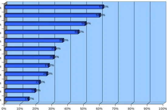
The Popular Outdoor Recreation Areas Statewide
Based on survey responses of how many day trips and overnight trips were taken in the last 12 months prior to the survey to sites in Massachusetts, the relative popularity of the outdoor recreation areas can be ranked. The resource areas experienced by most residents statewide (visitation rates higher than 30%) were:
• the coastal beaches and shorelines, with 61.5 % of respondents indicating visitation, and a projected usage of nearly 111 million person-trips annually;
• golf courses, parks, playground and tot lots were reported by 59.%; at 101 million person-trips per year, respondents also reported use of these facilities on a high frequency, relative to other categories;
• historic or cultural sites (50.4%);
• trips to lakes or ponds (46%);
• rivers and streams, (36.3 %);
• forests (31.4%); and
14.7% 18.8% 21.6% 26.3% 27.3% 30.4% 31.4% 36.3% 46.0% 50.4% 59.5% 61.5% 0% 10% 20% 30% 40% 50% 60% 70% 80% 90% 100% Percent of Respondents Agricultural Lands Wetlands Bikeways Mountains Wildlife Conservation Areas Trails or Greenways Forests Rivers or Streams Lakes or Ponds Historic or Cultural Sites Parks & Golf Courses Coastal beaches or shorelines
Recreati
onal
Area
Figure 9. Statewide Experience with Recreational Areas
These percentages, representing the proportion of the population that has experienced these areas at least once during the last 12 months, is further refined in the table below. This table expresses a combination of both the frequency and number of visitors in a “projected” (inferred rather than a direct site count) number of annual visits. Note how the relative popularity of historical or cultural sites falls in rank order, while wetlands rise dramatically when expressed in this fashion, and how agricultural land areas and wildlife conservation areas reverse their rank order. Bikeways and mountain areas also reverse their rank order when total projected demand in days is computed.