Proceedings of the Surveying and Spatial Sciences Conference 2013 15 – 19 April 2013 Canberra Australia
Using GNSS CORS to Augment Long-Term Tide Gauge
Observations in NSW
Volker Janssen1, Russell Commins1, Phil Watson2, Simon McElroy1 1Land and Property Information, NSW Department of Finance and Services
346 Panorama Avenue, Bathurst NSW 2795, Australia
[email protected], [email protected], [email protected] 2Office of Environment and Heritage, NSW Department of Premier and Cabinet
Locked Bag 1002, Dangar NSW 2309, Australia
ABSTRACT
The tide gauge records available from Fort Denison, Sydney Harbour and the Pilot Station, Newcastle in New South Wales (NSW), Australia are two of the longest continuous records of this type in the southern hemisphere. By virtue, these records are of considerable national and
international importance in relation to sea level rise and climate change research. Long-term tide gauge records provide a measure of the water level relative to a fixed, land-based reference mark. However, in order to precisely determine any apparent sea level change, it is important to know whether or not the land upon which the tide gauge is located is actually moving. Processes that can contribute to land movement include plate tectonics, glacial isostatic adjustment and localised factors that contribute predominantly to subsidence (e.g. groundwater extraction, land reclamation and development loadings). In order to determine a rigorous estimation of sea level change, these processes need to be taken into account, i.e. is the sea level rising or the land falling? Global Navigation Satellite System (GNSS) Continuously Operating Reference Stations (CORS) are the ideal candidate to provide accurate and continuous measurements of land movement at tide gauge locations. Following analysis of an accurate time series of this land movement, relative tide gauge observations can be readily adjusted to measure the absolute changes in ocean water levels over time. This paper outlines the high scientific value of augmenting tide gauge records with GNSS CORS and provides an insight into the considerable difficulties encountered in the installation of GNSS CORS in sensitive, heritage-listed, harsh marine environments. It focuses on the
construction of two CORS installed at the Fort Denison and Pilot Station tide gauges, which have been integrated into the CORSnet-NSW network managed by Land and Property Information to deliver high-accuracy positioning infrastructure for NSW.
KEYWORDS:
GNSS, CORSnet-NSW, CORS installation, tide gauges, sea level rise, climate change
1 INTRODUCTION
profound economic, social, environmental and planning consequences (e.g. Watson and Lord, 2008; Watson, 2011).
In this context, it is becoming increasingly important to monitor trends emerging from local (regional) sea level records to augment global average measurements and future projections (Meyssignac and Cazenave, 2012). Long-term changes in mean sea level relate to variations in ocean currents, changes in the volume of water in the oceans and thermal expansion of the ocean water mass. The tide gauge records available from Fort Denison, Sydney Harbour (since 1886) and the Pilot Station, Newcastle (from 1925) in New South Wales (NSW), Australia are two of the longest continuous records in the southern hemisphere. By virtue, these records are of
considerable national and international importance in relation to sea level rise and climate change research.
Long-term tide gauge records provide a measure of the water level relative to a fixed, land-based reference mark. However, in order to allow a rigorous estimation of sea level change, it is important to determine whether or not the land upon which the tide gauge is located is actually moving, i.e. is the sea level rising or the land falling? Processes that can contribute to land
movement include plate tectonics (including earthquakes and volcanic eruptions), glacial isostatic adjustment (the ongoing rise of land masses that were depressed by the large weight of ice sheets during the last glacial period) and anthropogenic factors that contribute predominantly to
subsidence (e.g. groundwater extraction, land reclamation and development loadings). Global Navigation Satellite System (GNSS) Continuously Operating Reference Station (CORS) networks are being introduced across Australia and internationally to provide improved access to positioning infrastructure for a wide range of applications in areas such as surveying, mapping and asset management, precision agriculture, engineering and construction, airborne imaging and sensors, and utilities management. Benefits include datum definition, rationalisation of infrastructure, consistent and reliable connectivity to the national datum, and the ability to provide a degree of legal traceability for satellite-based positioning.
These GNSS CORS are the ideal candidate to provide accurate and continuous
measurements of land movement at tide gauge locations. Following analysis of the resulting land movement time series, relative tide gauge observations can be readily adjusted to measure the absolute changes in ocean water levels over time.
This paper outlines the high scientific value of augmenting tide gauge records with GNSS CORS technology and provides an insight into the considerable difficulties encountered in the installation of GNSS CORS in sensitive, heritage-listed, harsh marine environments. It focuses on the construction of two CORS installed at the Fort Denison and Pilot Station tide gauges, which have been integrated into the CORSnet-NSW network managed by Land and Property Information (LPI) to deliver high-accuracy positioning infrastructure for NSW.
2 IMPORTANCE OF LAND MOVEMENT OBSERVATIONS AT TIDE GAUGE SITES
Long continuous tide gauge records are invaluable for sea level change research because dynamic oceanographic and meteorological impacts can be increasingly averaged out (or isolated) over time to reveal the comparatively small underlying change in mean sea level. These “relative” tide gauge measurements are, however, a combination of the actual change in mean sea level and the vertical movement of the land upon which the tide gauge installation is located.
The vertical land motion at a tide gauge site can be as large as the sea level change, thereby greatly complicating determination of sea level trends (Woodworth, 2006). Generally, sea level trends obtained from tide gauge records are only adjusted for glacial isostatic adjustment since other vertical land motion components are not known (Houston and Dean, 2011).
underground mining, having subsided by approximately 60-70 mm over the period from 1940 to 2000 alone (Watson, 2011).
These examples highlight the necessity to understand land movements so that they can be adequately considered in order to use local, relative tide gauge data to provide improved estimates of eustatic sea level rise (i.e. sea level rise due to changes in the volume of the oceans).
3 GNSS CORS
GNSS is increasingly being used for applications related to environmental monitoring (Awange, 2012). This includes GNSS-based radio telemetry (enhancing ecological and
conservation monitoring by more accurately mapping animal movements, behaviours and their impact on the environment – e.g. see Tomkiewicz et al., 2010; Janssen, 2012), GNSS meteorology (contributing to weather and climate change studies – e.g. Choy et al., 2011), GNSS remote
sensing (allowing rapid monitoring of changes in fresh water resources and the cryosphere – e.g. Jin and Komjathy, 2010), and epidemiology (improved efficiency in tracking and studying the spread of infectious diseases and climate change effects on vector-borne diseases – e.g. Carpenter, 2012).
Co-located GNSS CORS are the ideal tool for providing accurate and continuous
measurements of land movement at tide gauge locations (Tervo et al., 2007). While GNSS has long been used to determine horizontal land movements to high accuracy, recent studies have shown that GNSS is also able to provide vertical land motion monitoring with an accuracy of better than 1 mm/yr, thereby improving the estimation of sea level rates both regionally (e.g. Bingley et al., 2001; Buble et al., 2010) and globally (e.g. Wöppelmann et al., 2009; Bouin and Wöppelmann, 2010).
[image:3.595.56.538.464.614.2]Compared to traditional monitoring methods based on terrestrial surveying techniques, the use of GNSS technology offers significant improvements in the measurement of land movements at tide gauges. A brief comparison of these two approaches is provided in Table 1, listed in order of priority and highlighting the advantages of utilising GNSS CORS.
Table 1: Comparison of landform movement monitoring using traditional terrestrial survey methods and GNSS CORS.
Issue Priority Terrestrial Methods GNSS CORS Techniques
Monitoring 1 episodic/sporadic continuous
Reference Frame 2 local global
Land Motion 3 relative absolute
Data 4 internal, validated in-house shared, validated by others
Precision 5(a) generally fixed improving with time/algorithms
Accuracy 5(b) survey specific homogeneous across all sites
Data Archiving 6 manual & centralised electronic & distributed
Labour 7 intensive automated
Intent & Outcome 8 defined/limited multi-user/infrastructure
Alarms 9 n/a near-real time (variable thresholds)
relative tide gauge observations can be readily adjusted to measure the absolute (or eustatic) changes in ocean water levels over time.
3.1 CORSnet-NSW
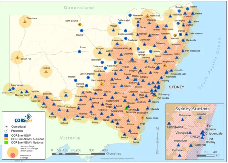
CORSnet-NSW is a rapidly growing network of GNSS CORS providing fundamental positioning infrastructure for all of New South Wales that is accurate, reliable and easy to use (Janssen et al., 2011a; LPI, 2013). It is built, owned and operated by Land and Property Information (LPI), a division of the NSW Department of Finance and Services. CORSnet-NSW currently (March 2013) consists of 120 CORS tracking multiple satellite constellations. Efforts are underway to expand the network to over 150 stations by mid 2014.
[image:4.595.67.534.308.641.2]The coverage of CORSnet-NSW is illustrated in Figure 1, showing stations that are operational (indicated by small triangles) as well as some planned stations (indicated by small circles). A 50 km radius around active stations is shown to illustrate the maximum recommended coverage area for single-base Real Time Kinematic (RTK) operation, while Network RTK (NRTK) coverage at the 2-cm level (horizontally) is shown as a striped, pink polygon in areas that have sufficient station density to support this technique. Currently, 55% of the area of NSW (and 98% of the population) is covered by the single-base RTK service, while NRTK is available to 37% of the area of NSW (and 94% of the population).
Figure 1: CORSnet-NSW network map as of March 2013 (LPI, 2013).
A dozen CORSnet-NSW stations are being built to international geodetic specifications with joint state/federal funding as part of the scientific, national AuScope CORS network (Janssen, 2009). This includes Port Kembla CORS, installed in March 2010 and located within 260 m of the Port Kembla high-precision tide gauge (Figure 2) managed by the National Tidal Centre as part of the Australian Baseline Sea Level Monitoring Project (BoM, 2013). The Fort Denison and
Newcastle East (Pilot Station) CORS have been primarily funded by the NSW Office of Environment and Heritage, specifically to augment the long-term tide gauges located at these sites. All CORSnet-NSW reference stations are equipped with the most recent dual or triple
order to provide a legally traceable survey monument that allows the GNSS antenna to be oriented to True North without the need to introduce an antenna height, the new CORSnet-NSW Adjustable Antenna Mount (CAAM) was developed and patented by LPI for use within CORSnet-NSW
(Commins and Janssen, 2012).
Figure 2: (a) Port Kembla CORS and (b) Port Kembla high-precision tide gauge.
4 INSTALLATION OF CORS AT TIDE GAUGE LOCATIONS
Owing to their length and continuity, the Fort Denison and Newcastle tide gauge records are two of the most important continuous sea level records available for the southern hemisphere. Perhaps surprisingly, these critical tide gauges are not part of the Australian Baseline Sea Level Monitoring Project or the South Pacific Sea Level and Climate Monitoring Project, but instead managed by individual port authorities. While these gauges are satisfactorily managed to facilitate the day-to-day operational requirements of commercial ports, they do not utilise consistent
technologies or operating procedures or contain sufficient survey records to consider vertical land movements at each individual tide gauge over the record length. The installation of GNSS CORS at tide gauge locations can overcome these issues.
However, it is well known that building a GNSS CORS network is a challenging, expensive and time-consuming task (Janssen et al., 2011b; LPI, 2012). The purpose of the network
determines the required network density and station monumentation. The logistics involved in physically building the monument and installing the electronic equipment are some of the easiest issues requiring consideration. Collaboration with other organisations hosting a CORS, long-term tenure of the land and/or building to be used, site access, system redundancy and communications all play crucial roles. In addition, several operational aspects need to be addressed in order to provide (and achieve) reliable GNSS positioning of homogeneous and high accuracy across the network. These include the consistent connection to a high-quality datum, GNSS-based height transfer considerations, the use of absolute GNSS antenna models, stability and integrity monitoring, and the possible contribution to regional or global initiatives requiring GNSS CORS data.
When choosing a new CORS site, careful consideration should be given to the surrounding environment (e.g. access to bedrock, no radio interference, clear skyview and low multipath environment). However, in the case of a tide gauge, the conditions are usually far from ideal, particularly in a busy port. In addition, considerable difficulties may have to be overcome if the new CORS is to be installed in sensitive, heritage-listed, harsh marine environments.
Ideally, the GNSS CORS should be co-located with the tide gauge. However, in practice this is often not possible due to factors such as the physical location of the tide gauge (e.g. in a room at Fort Denison or on top of a stilling well in Newcastle), the marine environment being extremely challenging (e.g. negative effects of salt, wind and water), port land being prime real estate, jetties being subject to physical disturbances from vessels, and Work Health and Safety issues. CORS construction at any tide gauge is known to be the most challenging of all such constructions, requiring the use of special materials and techniques to protect the sensitive electronic equipment from the harsh environment (e.g. marine-grade stainless steel mounts, dual air filters and sealed
[image:5.595.174.425.120.288.2]cabinets). For CORS placed in public view, security concerns (e.g. installation of security cameras and tamper-proof antenna mounts, cabling and cabinets) and aesthetic considerations are
generally also required. Understandably, these factors contribute to significantly higher installation costs. Consequently, the planning, preparation, hardware requirements, associated approvals and installations for the Fort Denison and Newcastle East (Pilot Station) CORS were not
straightforward exercises.
4.1 Fort Denison CORS
Fort Denison is recognised as an historic fortification that remains an enduring iconic feature in Sydney Harbour. The history of the Fort and nature of its massive sandstone construction, combined with its isolation and comparative inaccessibility, adds to its landmark status within the harbour. Fort Denison was added to the Sydney Harbour National Park in 1995 and the State Heritage Register in 1999. It has also been included on the Register of the National Trust.
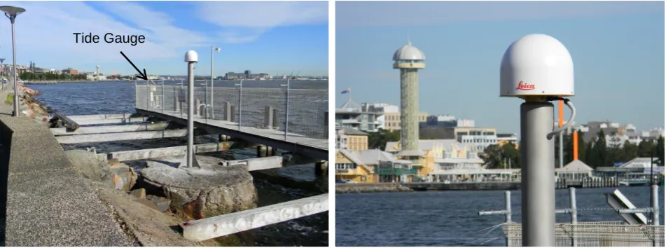
The current Vitel Acoustic Gauge was installed in a room at Fort Denison in 1996. It records the water level every minute by calculating an average maximum and minimum value over 54 measurements. The data is sent via modem to the Sydney Ports Corporation (SPC) and stored in a database where it is accessible in real time on the SPC web page (SPC, 2013). The tide gauge contains a bench mark (BM) that is used as the reference point for the level connection to
[image:6.595.173.425.319.490.2]surrounding survey control (Figure 3).
Figure 3: Fort Denison tide gauge and its tide gauge BM.
Under NSW heritage legislation, a Heritage Impact Statement (HIS) which addresses the management actions and principles of the Fort Denison Conservation Management Plan was required for the CORS construction to go ahead. Although development consent for a tide gauge CORS is not required under the State Environmental Planning Policy (SEPP) 2007 (Infrastructure SEPP), the prominent nature of the site required the preparation of a Review of Environmental Factors (REF) with the HIS. Due to the specific heritage nature of the Fort, the following constraints were imposed in addition to the standard selection criteria for CORS sites:
• Must have a negligible effect on the silhouette of the island (i.e. short mount with a low-profile antenna).
• Must not cause any damage or change to the original fabric of the Fort (classified as being of primary significance), i.e. drilling sandstone is prohibited.
• Must involve minimal changes to any part of the island (all areas, even recent additions, are classified as significant in the Conservation Management Plan).
• Must be compatible with the existing uses of the Fort.
• Must not involve any excavation.
• Should be constructed on bedrock for the maximum possible vertical stability.
• Must be constructed entirely from materials that will not corrode in the harsh marine environment.
Denison CORS was constructed within 75 m of the tide gauge and became operational on 18 May 2012. It consists of a 3.3 m tall sandblasted, marine-grade stainless steel pillar of 150 mm diameter with integrated CAAM (Figure 4). The CORS pillar was secured by two 16 mm stainless steel rods penetrating through the existing modern concrete slab into the bedrock below and braced with four 10 mm stainless steel rods set into the brick wall (the bricks were embedded in the original
[image:7.595.60.539.146.313.2]stonework of the Fort during the latter half of the 20th century).
Figure 4: Antenna mount (including CAAM) at Fort Denison CORS.
4.2 Newcastle East CORS
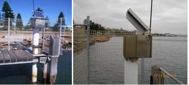
The current Newcastle tide gauge is a Unidata float-activated rotary tide gauge, installed in September 2001. It is housed within an enclosure mounted on top of a stilling well adjacent to the Pilot Station Finger Jetty and located approximately 1.5 km inside the breakwater entrance to the Hunter River (Figure 5). Tide gauge data is sent via telemetric link to the Newcastle Port
Corporation’s (NPC’s) Swell Analysis and Under-keel Clearance System (SAUCS) and then passed on to an external consultant via landline for filtering. A minimal filtering process is used whereby 10-second raw data is collected into a 1-minute array and a standard deviation approach is used to reject outliers. Additional checks for erroneous data are performed via the inspection of daily tide plots and the continuous recording of residuals.Any data gaps are replaced by
secondary gauge information obtained from a VegaPuls radar-type tide gauge installed about 40 m further east on the other side of the jetty in September 2008.
Figure 5: Pilot Station tide gauge in Newcastle.
[image:7.595.112.488.521.691.2]Unlike Fort Denison, other considerations at Newcastle included the construction of a new port operations building at the eastern end of the Pilot Station property. Excavation for construction indicated that the boat harbour entrance and surrounds were almost certainly constructed from fill, primarily stone boulders and sand. This would make a stable monument almost impossible to build in that particular area (initially the preferred location). A new pier for the GNSS CORS was
considered but, in consultation with a wharf construction contractor, was discounted as the required stability could not be attained given the area’s tide surge characteristics and relatively shallow bedrock (i.e. a pile could not be driven into unconsolidated material, nor could a concrete foundation be made on the surface).
During the reconnaissance phase, an old crane foundation was noticed but initially
discounted due to possible heritage significance (and an accompanying council plaque). However, following further investigations it was discovered that:
• The crane base at the proposed CORS site was not listed in the State Heritage Register (unlike 14 others in the area), nor was it listed in schedule 5 of the Newcastle City Centre LEP 2008, schedule 6 of the Newcastle LEP 2003 or the revised Newcastle LEP 2012 (draft available at the time of consideration).
• The crane base was located outside the Coal River Heritage Precinct and the Newcastle East Heritage Conservation Area. It also fell outside the area described and shown as a general heritage item (Stone Boat Harbor) in the Newcastle City Centre LEP 2008 and its
accompanying map (heritage map sheet HER-002). Due to the above, formal approval under the Heritage Act to construct the CORS at this location was not required. It should be stressed, however, that Council was formally consulted nonetheless and had no objections.
• Even though the above meant that heritage approval was not required, the crane foundation obviously held historical significance. Consequently, great care was taken in preparing a design and installation method that ensured minimal permanent impact on the structure.
Following attainment of all relevant approvals, facilitation of all necessary heritage
[image:8.595.62.538.476.653.2]considerations and rigorous, successful pre-testing of alternative hardware setups, the Newcastle East CORS was constructed within 30 m of the Pilot Station tide gauge and became operational on 26 June 2012. It consists of a 3.0 m tall marine-grade stainless steel pillar of 170 mm diameter with integrated CAAM, secured to the old crane foundation by six 16 mm stainless steel rods embedded more than 300 mm into the concrete (Figure 6). The CORS pillar was specifically designed to be difficult to climb or vandalise.
Figure 6: Newcastle East CORS installation (including CAAM).
5 SURVEY CONNECTION BETWEEN CORS AND TIDE GAUGE SITES
Since both GNSS CORS could not be co-located with their respective tide gauges, it is crucial to provide a surveyed connection between these two continuously measuring instruments. This so-called tie survey continues to be performed episodically, thereby constituting a weak link that cannot be avoided at this stage. LPI will ensure that these ties are observed with the required precision (<1 mm) and temporal resolution (generally every two years). Such tie surveys have
been performed by LPI at the Port Kembla site for the last 20 years in order to connect the tide gauge to existing ground control marks (and now the Port Kembla CORS).
Within the CORSnet-NSW network, all GNSS observations are referenced to the Antenna Reference Point (ARP), which was used for the initial level connection between CORS and tide gauge. However, the ARP (Figure 7a) is not accessible once the GNSS CORS antenna is
installed. Therefore, the CORS monument includes a bench mark designed for precise EDM height transfer (Figure 7b) that was connected to the ARP during the initial tie survey to obtain height differences between the ARP, the CORS BM and the tide gauge BM.
Figure 7: (a) ARP and (b) CORS BM at Fort Denison CORS.
A highly accurate height connection between the ARP of the GNSS CORS and the tide gauge BM is crucial. The initial survey was performed using the EDM heighting method. In order to ensure that the results met class L2A survey specifications (ICSM, 2007), the following techniques were employed by LPI:
• Precise total station with quoted accuracy of 0.5” and ± (1.0 mm + 1.0 ppm) used.
• Precise prism with a 0.0 mm offset used as target.
• Precise prism attached to a dedicated stainless steel rod of fixed and accurately calibrated height.
• Bipod used to secure the stainless steel rod.
• Maximum sighting distance of 40 m.
• Meteorological data (i.e. temperature, pressure and relative humidity) entered into the instrument every 30 minutes.
• Instrument calibration performed before the survey.
• Five Face-Left/Face-Right arcs observed to each mark.
• Closed-loop survey performed to connect CORS ARP, CORS BM and tide gauge BM.
• No intermediate sights taken.
Unfortunately, a discernible tide gauge BM was not available on the Pilot Station tide gauge when the GNSS CORS was installed. Calibration of the Unidata tide gauge is performed by sighting to a series of fixed beads on the float gauge wire that is directly related to the water level in the stilling well and therefore does not require a BM on the gauge itself. Consequently, the tie survey (performed using the aforementioned EDM heighting method) only determined the height difference between the ARP and the CORS BM (Figure 8). However, it should be noted that the placement of a tide gauge BM on the gauge itself has since been proposed and is currently under review. This new tide gauge BM and the CORS BM will be included in a spirit level connection each time the tide gauge is officially calibrated and connected to a BM adjacent to the tide gauge by NPC staff (i.e. annually).
(a) (a) (b)
ARP
[image:9.595.143.456.168.335.2]Figure 8: (a) ARP and (b) CORS BM at Newcastle East CORS.
6 CONCLUSION
This paper has outlined the high scientific value of augmenting tide gauge records with GNSS CORS technology in order to separate the land motion and sea level change signals contained in relative tide gauge records. It has also provided an insight into the considerable difficulties encountered in the installation of GNSS CORS in sensitive, heritage-listed and harsh marine environments.
The Fort Denison and Newcastle East (Pilot Station) CORS will provide valuable continuous measurements on land movements to augment two of the longest tide gauge records in NSW and the southern hemisphere. Including the Port Kembla CORS, the positioning infrastructure in NSW now incorporates three GNSS CORS in close proximity to tide gauges. It should be recognised that these CORS have only been operational for a very short period of time and that these
measurements will become increasingly important as the record length increases (to greater than 10-15 years or so), providing significantly improved estimates of regional eustatic sea level change into the future. The utilisation of GNSS technology will substantially remove uncertainty of ground movement rates contained within the measured relative sea level measurements and thus
significantly improve the scientific value of the tide gauge data.
The installation of the Fort Denison and Newcastle East CORS has been the result of a considerable collaborative effort by a range of NSW Government agencies (i.e. LPI, Office of Environment and Heritage, Sydney Ports Corporation and Newcastle Port Corporation) to meet challenging technical, environmental and heritage constraints.
ACKNOWLEDGEMENTS
The successful installation of the Fort Denison and Newcastle East CORS would not have been possible without substantial cross-agency cooperation. In particular, the authors would like to acknowledge the contribution of the following individuals: Elisha Long and Cath Snelgrove (Office of Environment and Heritage), Gary Batman (Sydney Ports Corporation), David Connors and Andrew Wood (Newcastle Port Corporation). AuScope is thanked for its support in the construction of Port Kembla CORS.
REFERENCES
Awange J.L. (2012). Environmental Monitoring using GNSS. Springer, Berlin, 382pp.
Belperio A.P. (1993). Land subsidence and sea level rise in the Port Adelaide estuary: Implications for monitoring the greenhouse effect. Australian Journal of Earth Sciences, 40(4), 359-368.
ARP BM
[image:10.595.116.482.55.219.2]Bingley R., Dodson A., Penna N., Teferle N., Baker T. (2001). Monitoring the vertical land movement component of changes in mean sea level using GPS: Results from tide gauges in the UK. Journal of Geospatial Engineering, 3(1), 9-20.
BoM (2013). Australian Baseline Sea Level Monitoring Project,
http://www.bom.gov.au/oceanography/projects/abslmp/abslmp.shtml (accessed Mar 2013).
Bouin M.N., Wöppelmann G. (2010). Land motion estimates from GPS at tide gauges: A geophysical evaluation. Geophysical Journal International, 180(1), 193-209.
Buble G., Bennett R.A., Hreinsdottir S. (2010). Tide gauge and GPS measurements of crustal motion and sea level rise along the eastern margin of Adria. Journal of Geophysical Research, 115, B02404, doi:10.1029/2008JB006155.
Carpenter T.E. (2012). The spatial epidemiologic (r)evolution: A look back in time and forward to the future. Spatial and Spatio-temporal Epidemiology, 2(3), 119-124.
Choy S., Zhang K., Wang C.-S., Li Y., Kuleshov Y. (2011). Remote sensing of the earth’s lower atmosphere during severe weather events using GPS technology: A study in Victoria, Australia. Proceedings of ION GNSS 2011, Portland, Oregon, 20-23 September 2011, 559-571.
Church J.A., White N.J., Coleman R., Lambeck K., Mitrovica J.X. (2004). Estimates of the regional distribution of sea level rise over the 1950-2000 period. Journal of Climate, 17(13), 2609-2625.
Commins R., Janssen V. (2012). Improving GNSS CORS Design: The CORSnet-NSW Adjustable Antenna Mount (CAAM). Journal of Global Positioning Systems, 11(1-2), in press.
Houston J.R., Dean R.G. (2011). Sea-level acceleration based on U.S. tide gauges and extensions of previous global-gauge analyses. Journal of Coastal Research, 27(3), 409-417.
ICSM (2007). Standards and practices for control surveys (SP1), version 1.7,
http://www.icsm.gov.au/publications/sp1/sp1v1-7.pdf (accessed Mar 2013).
Janssen V. (2009). Precision rules! How to establish an AusCORS site. Position, 44, 64-66.
Janssen V. (2012). Indirect tracking of drop bears using GNSS technology. Australian Geographer, 43(4), 445-452.
Janssen V., Haasdyk J., McElroy S., Kinlyside D. (2011a). CORSnet-NSW: Improving positioning infrastructure for New South Wales. Proceedings of SSSI Biennial Conference (SSSC2011), Wellington, New Zealand, 21-25 November 2011, 395-409.
Janssen V., Haasdyk J., McElroy S., Kinlyside D. (2011b). Technical challenges faced by CORS network operators: Experiences from New South Wales, Australia. International Journal of Geoinformatics, 7(3), 23-33.
Jin S., Komjathy A. (2010). GNSS reflectometry and remote sensing: New objectives and results. Advances in Space Research, 46(2), 111-117.
Lambeck K. (2002). Sea-Level change from mid-Holocene to recent time: An Australian example with global implications. In: Ice Sheets, Sea Level and the Dynamic Earth (Mitrovica J.X.,
Vermeersen B.), American Geophysical Union, Washington DC, 33-50.
LPI (2012). Guidelines for CORSnet-NSW Continuously Operating Reference Stations (CORS), version 1.1. Available from http://www.lpi.nsw.gov.au/surveying/corsnet-nsw/user_guides
(accessed Mar 2013).
Meyssignac B., Cazenave A. (2012). Sea level: A review of present-day and recent-past changes and variability. Journal of Geodynamics, 58, 96-109.
Sanchez L., Bosch W. (2009). The role of the TIGA project in the unification of classical height systems. In: Geodetic Reference Frames (Drewes H.), IAG Symposia, 134, Springer, 285-290.
SPC (2013). Wave, wind and tide,
http://www.sydneyports.com.au/port_operations/wave_wind_and_tide (accessed Mar 2013).
Tervo M., Poutanen M., Koivula H. (2007). Tide gauge monitoring using GPS. In: Dynamic Planet (Tregoning P., Rizos C.), IAG Symposia, 130, Springer, 75-79.
Tomkiewicz S.M., Fuller M.R., Kie J.G., Bates K.K. (2010). Global Positioning System and
associated technologies in animal behaviour and ecological research. Philosophical Transactions of the Royal Society B: Biological Sciences, 365(1550), 2163-2176.
Watson P.J. (2011). Is there evidence yet of acceleration in mean sea level rise around mainland Australia? Journal of Coastal Research, 27(2), 368-377.
Watson P.J., Lord D.B. (2008). Fort Denison sea level rise vulnerability study. Report prepared by the Coastal Unit, NSW Department of Environment and Climate Change.
Williams S.D.P., Penna N.T. (2011). Non-tidal ocean loading effects on geodetic GPS heights. Geophysical Research Letters, 38, L09314, doi:10.1029/2011GL046940.
Woodworth P.L. (2006). Some important issues to do with long-term sea level change. Philosophical Transactions of the Royal Society, 364(1841), 787-803.