· · ·
:ί· il
β *
•s
w Λ w i
Ί·:·Ι·
• ι · · · · · ·
· · · · : · . .
• • • s
· · · ■• • • 3
mir'I.
eî·!
European Union
Regional policy
« «
: · " · ■
Regional development studies
The EU compendium
of spatial planning
systems and policies
Belgium
mmm
MbáLí
iå;
Belgium
Denmark
Germany
Greece
Spain
France
Ireland
Italy
Luxembourg
The Netherlands
Austria
Portugal
Finland
Sweden
Ui lited Kingdom
European Union
Regional policy
Regional development studies
The EU compendium
of spatial planning
systems and policies
Belgium
Already published in the series 'Regional development studies'
01 — Demographic evolution through time In European regions (Demeter 2015)
02 — Socioeconomic situation and development of the regions In the neighbouring countries of the Community in central and eastern Europe
03 — Les politiques régionales dans l'opinion publique
04 — Urbanisation and the functions of cities in the European Community
05 — The economic and social impact of reductions in defence spending and military forces on the regions of the Community
06 — New location factors for mobile investment in Europe — Final report
07 —Trade and foreign investment in the Community's regions: the impact of economic reform in central and eastern Europe
08 — Estudio prospectivo de las regiones atlánticas — Europa 2000 Study of prospects in the Atlantic regions — Europe 2000 Étude prospective des régions atlantiques — Europe 2000 Estudo prospectivo das regiões atlânticas — Europa 2000
09 — Financial engineering techniques in regions covered by Objectives 1, 2 and 5b of the Community regional policies
10 — Interregional and cross-border cooperation in Europe 11 — Estudio prospectivo de las regiones del Mediterràneo Oeste
Évolution prospective des régions de la Méditerranée-Ouest
Evoluzione delle prospettive delle regioni del Mediterraneo occidentale 12 —Valeur ajoutée et ingénierie du développement local
13 — The Nordic countries — What impact on planning and development in the Union? 14 — Development prospects of the central Mediterranean regions (Mezzogiorno-Greece) 15 —The spatial consequences of the integration of the new German Länder into the Community
16 — The impact of the development of the countries of central and eastern Europe on the Community territory 17 — Étude prospective des régions de l'arc alpin et périalpin
Studio delle prospettive delle regioni dell'arco alpino e pedalpino 18 — The prospective development of the northern seaboard
19 — L'impact sur le développement régional et l'aménagement de l'espace communautaire des pays du sud et de l'est méditerranéen (PSEM)
20 — Evolución prospectiva de las regiones interiores (y de los espacios rurales de baja densidad de población en la Comunidad)
Évolution prospective des régions intérieures (et des espaces ruraux de faible densité de population de la Communauté)
21 —The regional impact of the Channel Tunnel throughout the Community 22 — Prospects for the development of the central and capital cities and regions 23 — La notoriété des politiques régionales en Europe
24 — Cohesion and the development challenge facing the lagging regions
25 — In den Regionen für die Regionen Europas — Über die Aneignung eines neuen gewerkschaftlichen Arbeitsfeldes At regional level on behalf of Europe's regions — Developing a new field of trade union activity
Agir dans les régions pour l'Europe des régions — Un nouveau champ d'activités syndicales 26 —The impact of structural policies on economic and social cohesion in the Union 1989-1999
Die Auswirkungen der Strukturpolitik auf die wirtschaftliche und soziale Kohäsion in der Union 1989-1999 L'impact des politiques structurelles sur la cohésion économique et sociale de l'Union — 1989-1999 27 — Community involvement in urban regeneration: added value and changing values
28 — The EU compendium of spatial planning systems and policies
29 — Economic and social cohesion in the European Union: the impact of Member States' own policies
A great deal of additional information on the European Union Is available on the Internet. It can be accessed through the Europa server (http://europa.eu.int) and the Inforegio website (http://inforegio.cec.eu.int).
Cataloguing data can be found at the end of this publication.
Luxembourg: Office for Official Publications of the European Communities, 2000
ISBN 92-828-2694-5
© European Communities, 2000
Reproduction is authorised provided the source is acknowledged.
Cover photos: Brussels, the Atomium in the evening/Castle and moat in Bruges
Preface
Each year, the Regional Policy Directorate-General of the European Commission launches a number of studies in the field of regional policy and regional planning. These studies mainly aim at providing a basis for policy formulation internally, as well as the preparation of programmes and initiatives and a basis for analysing the impact of current or planned activities. The most interesting or innovative of these are published in a series entitled 'Regional development studies'.
With this series, the Directorate-General hopes to stimulate discussion and action in a wider sphere on the research results received. The publication of the studies is addressed to politicians and decision makers at European, regional and local level, as well as to academics and experts in the broad fields of issues covered.
It is hoped that by publicising research results the Commission will enrich and stimulate public debate and promote a further exchange of knowledge and opinions on the issues which are considered im portant for the economic and social cohesion of the Union and therefore for the future of Europe.
Readers should bear in mind that the study reports do not necessarily reflect the official position of the Commission but first and foremost express the opinion of those responsible for carrying out the study.
Contents
Compendium's objectives 17
Author's note 21
A. OVERVIEW OF PLANNING SYSTEM 23
General summary 23
Principles 23 Historical background 24
Plan levels in Belgium 25 Spatial planning in a federal State 25
The 1962 Spatial Planning Act 25 Planning instruments in the 1990s 29
Planning and development 33 Sources and further information 33
Context and principles 33
Constitution, legislation and judicial system 33
Constitution 33 Judicial system 34 Legislation 34 Sources and further information 35
Development process and market circumstances 35
Development process 35 Sources and further information 36
Economic development 36 Economic development 36 Sources and further information 36
Environmental policy 36 Environmental policy 36 Sources and further information 37
European Union 38 Impact of the European Union on planning 38
Cross-border cooperation 39 Sources and further information 39
Flexibility versus certainty 39 Contents of spatial plans 39 Review of spatial plans 39 Deviation from spatial plans 39 Sources and further information 39 Government structure and powers 40
Government structure 40
Powers 45 Spatial planning powers 46
Implications of constitutional reforms on spatial planning and policies 47
Sources and further information 47 Land policy, land quality and building quality 48
Land policy 48 Land quality 48 Building quality 49 Sources and further information 49
Plan led/development led 49 Plan led versus development led 49
Sources and further information 49
Political priorities 50 Flemish Region 50 Walloon Region 50 Brussels Capital Region 50 Sources and further information 51 Political system, administrative system and public participation 51
Administrative system 51 Political system 52 Public participation 52 Sources and further information 53
Population and statistics 53 Population characteristics 53
Statistics 54
Trends 55
Central power — local power 55
Flemish Region 55 Walloon Region 55 Brussels Capital Region 55 Sources and further information 55
Flexibility versus certainty 55 Flexibility versus certainty 55 Sources and further information 56
Government structure 56 Government structure 56 Sources and further information 56
Policy trends 56 Policy trends 56 Issues which will affect the planning system in Belgium 57
Creation of cross-border regions 58
Cross-border issues 59 Sources and further information 60
B. MAKING AND REVIEWING PLANS AND POLICIES 61
Summary 61
Policy institutions 62
National Government 62 Federal government 62 Federal departments 62
Arbitragehof/Cours d'Arbitrage (Court of Arbitration) 62
Raad van State/Conseil d'Etat (State Council) 63
Regional government (three Regions) 63
Regional Council 63 Regional government 63 Administration of spatial planning and housing 64
Deconcentrated spatial planning departments 64
Regional government organisations 64 Regional advisory committees 64 Town Planning Council (Brussels Region only) 65
Provincial level (10 provinces) 65 Provincial Council 65 Permanent deputation 65 Spatial planning responsibilities 65
Provincial spatial planning services 65
Local government 65 Municipal level 65 Municipal Council 65 Council of mayor and aldermen 66
Spatial planning responsibilities 66 Municipal advisory committee 66 Municipal consultation committee (Brussels Region only) 66
Municipal spatial planning services 67
Other organisations 67
Policy instruments 76
National level 76 Regional level 76
Structure plan for Flanders 76 Walloon regional structure plan 76 Brussels Regional Development Plan 77 Brussels Regional Destination Plan 78
Sub-regional level 78 Sub-regional plan 78 Provincial level 80
Provincial spatial structure plan 80
Local level 80
Gemeentelijk structuurplan (Flemish Region) 80
Algemeen plan van aanleg (Flemish Region) 81
Schéma de structure communal (Walloon Region) 81
Municipal development plan (Brussels Capital Region) 82
Particular destination plan 82
Schéma-directeur 83
Technical plans 83 Expropriation plan 83 Alignment plan 83 Parcelling plan 83 Building plan 83 Other instruments 84
Building regulations 84 Environment impact assessment (EIA) 84
Control and sanctioning of violations 84
Expropriation 84
Development rights 85
Sources of further information 85
C. REGULATIONS AND PERMITS 87
Summary 87
Building permit 87 Good spatial planning 87 Basis for appeal 88
Main permit 89
Application for the permit 90
Contents 90 Process 90 Costs 91 Processing a permit 91
Process 91 Permit process in the Flemish and Walloon Region 91
Permit process in the Brussels Capital Region 96
Duration 97 Consultation 97 Automatic approval 98 Compensation 98 Conditions related to the permit 98
Circumstances 98 Status 99 Scope 99 Rights of appeal 99
Conditions and grounds of appeal 99
Process of appeal 99 Administrative appeal possibilities by applicant 100
Administrative appeal possibilities by CMA and DO 100
Appeal to the State Council 101 Appeal with judicial courts 101
Other permits 101
Demolition of a building 101 Perform a renovation 101 Convert a building 101 Deforestation 101 Changing the relief 101 Cutting down single tall trees 107
Cutting down or modifying remarkable trees and hedges 107 Exploitation of or changing the vegetation of heaths and peat 107 Construction of storage space for used cars or metal scrap 107
installation of movable constructions 107 Shop signs or advertising devices 107 Actions identified by a municipal regulation 107
Permit to allow small changes 107 Permit to allow plantations 107 Works on listed buildings, landscapes, townscapes or archaeological sites 107
Permit to allow the construction of a golf terrain 107
Parcelling permit 108
Exceptions 108
Exception of permit obligation 108 Autonomous power of municipalities 108
Departures from plan/changes to plan 109
Deviation from the plan in order to approve a development proposal 109 Deviation from the plan in order to disapprove a development proposal 110
Enforcement procedures 110
Administrative measures 110
Sanctions 111
Area of regulation 111
Unauthorised use and development 111
Sources and further information 112
D. AGENCIES AND MECHANISMS FOR DEVELOPMENT AND CONSERVATION 113
Summary 113
Development 113 Conservation 114
Environment and nature conservation 114 Pollution and waste management 114 Countryside conservation, urban conservation and monuments 114
Development 115 Regional economic development 115
Regional development corporations (RDCs) 115 Regional investment corporations (RIOs) 116 Regional socioeconomic councils (RSECs) 116
Local economic development 117 Intermunicipal cooperation 117 Sources and further information 118
Urban regeneration 118 Regional housing corporations (RHCs) 118
Sources and further information 119 Public sector development policies 119
Public sector development policies 119
Major infrastructure 119 Sources and further information 119
Partnerships 120 Inter-municipal cooperation 120
Tourism development 120 Tourism development 120 Sources and further information 121
Rural development 121 Regional land corporations (RLCs) 121
Protection of the environment and conservation 122
Countryside conservation 122 Flemish Region 122 Walloon Region 122 Brussels Capital Region 123 Sources and further information 124 Environmental conservation 124
Environment legislation 124 Flemish Region 125 Walloon Region 126 Brussels Capital Region 126 Further information 127 Coastal planning 127
Further information 127 Urban conservation 127 Protection, preservation and conservation of historic heritage 127
Preservation and conservation of historic buildings 128 Royal Commission of Monuments and Landscapes 128
Sources and further information 129 Waste management and resource planning 129
Waste management 129 Resource planning 130 Flemish Environment Corporation 130
Regional corporation for water supply 131
Key sources and further information 131
E. OVERVIEW 133
Summary 133
Principles of regional structure plans 134
Flemish Region 134 Walloon Region 135 Brussels Capital Region 135
Cross-border cooperation 136
Policy issues 136
Commercial development 136 Environment management 136
Heritage 136 Housing 137 Leisure and tourism 137
Transport and mobility 137 Pollution and waste management 137
Sources 137
F. POLICY STUDIES 139
Commercial development 139
Context 139 European policies 140
National policies 140 Federal level 140 Regional level 140 Local level 141
Municipal level 141
Sources 141
Economic and industrial development 141
European Union 141 Federal policy 141 Regional level 142 Local policy 142 Sources and further information 142
Environmental management 142
Context 142 European Union 143 National policies 143 Federal level 143 Regional policies 144
Regional level 144 Provincial level 144 Local policies 144 Municipal level 144 Sources 145
Heritage 145
Context 145 European Union 147 National policies 148 Regional policies 148
Regional level 148 Provincial level 148 Local policies 148
Municipal level 148 Other actors 148 Sources 149
Housing 149
Context 149 European Union 151
National policies 151 Federal level 151 Regional policies 151
Regional level 151 Provincial level 152 Local policies 152
Municipal level 152
Sources 152
Leisure and tourism 153
Context 153 European Union 154 Regional policies 154
Community/Region level 154
Provincial level 155 Local policies 155
Municipal level 155
Sources 155
Transport and mobility 155
Context 155 Road transport 156
Rail transport 156 Inland ports and waterways 156
Coastal shipping and ports 157
Airports 157 European Union 157 National policies 157 Federal level 157 Regional policies 158
Regional level 158 Provincial level 159 Local policies 159
Municipal level 159
Sources 160
Waste management and pollution 160
Context 160 European Union 161 National policies 161 Federal level 161 Regional policies 161 Local policies 162
Municipal level 162 Industry 162 Sources 162
APPENDICES
Appendix I. Glossary 163
Appendix II. Acronyms and abbreviations 171
Appendix III. Addresses 177
Appendix IV. General sources of further information, references and list of statutes 185
MAPS 189
List of tables
A1 Belgian political-administrative structure related to spatial planning 25
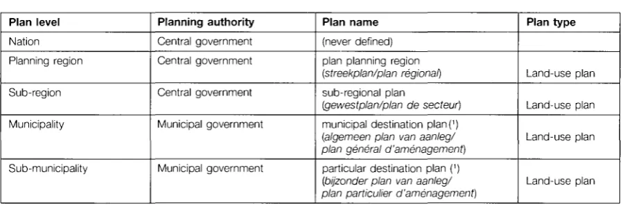
A2 Plan types of 1962 Spatial Planning Act 28 A3 Planning system in the Flemish Region until 1996 28
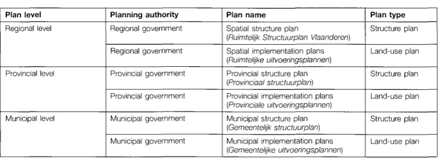
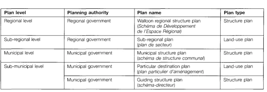
A4 Current planning system in the Flemish Region 29 A5 Planning system in the Walloon Region 30 A6 Planning system in the Brussels Capital Region 31 A7 Municipal plans in the Flemish Region, Walloon Region and Brussels Capital Region 31
A8 Relationship between the political-administrative levels, planning levels and planning instruments 32
A9 Competencies of the different courts 34 A10 Spatial planning related competencies of the different courts 34
A11 Legal terminology of Acts, Decrees, Ordinances and Decisions in a federal Belgium 44 A12 Summary of implications of the 1980-93 Constitutional reforms on spatial planning 48
A13 Population and Government statistics of the three Belgian Regions 54 A14 Population and Government statistics of the Belgian provinces and municipalities 54
A15 Average population statistics of the Belgian provinces and municipalities 54
B1 Municipal plans in the Flemish Region, Walloon Region and Brussels Capital Region 80 B2 Time limits to development rights granted by building permits in the three Regions 85
C1 Timing of the CMA relating to the permit application procedure in the Brussels Capital Region 97
C2 Need for prior advice of municipal decisions in the Flemish Region 97 C3 Automatic approval of development proposals in the three Regions 98
C4 Types of appeals and objections 99 C5 Appeal possibilities of the different actors 100
C6 Departure from plan in case of approval of the development proposal 110 C7 Departure from plan in case of refusal of the development proposal 110
D1 Proportion of mixed and pure intercommunales 118
F1 Heritage Budget of Belgian Regions 146
List of figures
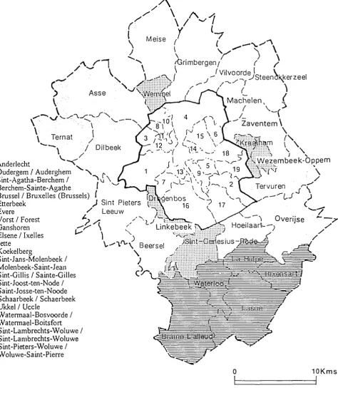
A1 Map of Regions and Provinces in Belgium 26 A2 Map of municipalities in and around Brussels Capital Region 27
A3 The institutional structure of federal Belgium (principle) 42 A4 The institutional structure of federal Belgium (practice) 43 A5 Map of population density in Belgium (1993) 191 A6 Map of evolution of the population density in Belgium (1983-93) 191
A7 Map of built-on surface in Belgium (1990) 192
B1 The institutional framework of the Belgian planning system 68 B2 The planning policy framework in the Flemish Region until 1996 69
B3 The planning system in the Flemish Region 70 B4 The 1999 planning policy framework in the Flemish region 71
B5 The planning policy framework in the Walloon Region 72
B6 The planning system in the Walloon Region 73 B7 The planning policy framework in the Brussels Capital Region 74
B8 The planning system in the Brussels Capital Region 75
B9 Structure plan for Flanders 193
B10 The Plan Régional d'Aménagement du Territoire Wallon 194
B11 The Brussels Regional Structure Plan (GeWOP) 195 B12 Sub-regional plan Aarschot-Diest Flemish Region 196 B13 Extract from the sub-regional plan Aarschot-Diest Flemish Region 197
B14 Joining together of the three sub-regional plans of the province of Limburg 198
B15 The Bijzonder Plan Remy Vest (Leuven - Flemish Region) 199 B16 The Alignment Plan and Expropriation Plan Mannenstraat leuven - Flemish Region 200
B17 Example of a building plan 201
C1 Submission of a building permit application 92 C2 Processing of an application by the municipal government 93
C3 Processing of an application by the delegated official 94 C4 Appeal with Permanent Deputation by permit applicant 102
C5 Appeal with Minister by permit applicant 103 C6 Appeal with minister by Municipal Government or delegated official 104
C7 Example form for a building permit application Flemish Region (translated) 105
C8 Example certificate of the architect (translated) 106
Compendium's objectives
The compendium is made up of numerous documents. The main volume is the Comparative review of systems and policies (Regional development studies — Study 28) which provides a summary of the characteristics of each system and illustrates the principal similarities and differences in approach across the EU. This was prepared from information supplied by subcontractors in each Member State which is also published in individual country volumes (Regional development studies — Study 28A to Study 28P). There are also volumes which consider the operation of planning in practice through examination of case studies on topics of particular interest to the EU.
The Informal Council of Ministers for Regional Policy and Planning confirmed in 1992 the need for a compendium of spatial planning systems and policies in the EU. The increasing need for cooperation between planners in different Member States at national, regional and local levels and the impact of EU policies within the changing economic, political and social context requires a better knowledge of the various mechanisms of spatial planning in other Member States.
The compendium is intended to provide an authoritative and comparable source of information on plan ning systems and policies, but is not intended to evaluate the relative merits or shortcomings of differ ent approaches. It Is recognised that the very different economic, social and cultural conditions across the EU can have a determining effect on the operation of spatial planning. The overriding objective of the compendium is to provide information in order to improve understanding of the variety of approaches.
Form and content
The principles that have guided the preparation of the compendium are that it should:
• provide an authoritative first source of information, but avoid unnecessary detail and should not re produce material readily available in the Member State;
• enable comparison of the systems and policies across different countries and regions, enabling the reader to cross-reference one section with similar material in other volumes;
• respond to the different needs of the many potential audiences, especially with regard to the foreign reader who will require an uncomplicated and comprehensible explanation;
• be built up step by step and allow for regular updating and expansion; • be produced in hard copy and computer formats.
Level of detail
These considerations have given rise to inevitable compromises in the production of the material, especially in balancing the need for an authoritative account whilst not overloading the text with
unnecessary detail. The panel of experts have been most helpful in determining where more or less (or clearer) explanation is required. The compendium is designed to provide summary descriptions of the main features of the system and thus explain how the system works. Obviously there is some variation in the complexity of the systems, especially where the law concerning spatial planning is extensive and complex, and thus the depth of understanding provided by the compendium for Member States will vary.
The compendium is certainly not intended to be a manual for operating within a particular system and does not replicate or reproduce extensive extracts of law or procedural guidance that is available in the Member State. The accounts are necessarily general. The categories used for the main structure are also very general because they need to apply to 15 different countries and an even larger number of systems. They are unlikely to be ideal categories or headings for a particular country, but all contribu tors have had to make a best fit for their system within these headings. The great benefit is that this gives considerable scope for very worthwhile comparisons. Sources of further information are given for those who need to explore in more depth.
Regional variations
The complexity of a 'planning system' will be great where federal or regionalised structures of govern ment give rise to major variations within the Member State. In these cases to avoid unnecessary com plexity and research, the approach agreed with the subcontractors and Commission was to provide an full explanation of one of the regions (where possible the most typical or widely applied system) and to note the major variations to this 'typical system' elsewhere. This approach is more easily adopted for some countries than others. Inevitably some important and interesting variations are not covered fully, and it is hoped that this can be addressed in future updating.
Structure
The compendium is published in two parts. The first comprises a country volume for each Member State on systems and policies. The second part comprises topic volumes where case studies of spa tial planning in practice from different countries are grouped together.
The country volumes of the compendium covering systems and policies include four main sections.
A. Overview
This is intended to give a brief explanation of the main features of the system, a description of the main factors that surround and shape it, current trends and a summary of the policy themes pursued at transnational, national, regional and local levels.
ß. Making and reviewing plans and policies
This is an explanation of the instruments which are used to guide spatial planning at national, regional and local levels, and the procedures which are used in their formulation.
C. Regulation and permits
This section provides an explanation of the types of regulation and permit systems predominantly used to control land-use change, and the procedures by which they are sought, granted and enforced.
D. Agencies and mechanisms for development and conservation
There are many other ways in which governments engage in spatial planning outside the preparation of plans and regulation, and this section provides a summary of the many organisations and mechanisms which are employed both in implementing development and in protecting the natural and built heritage. Each volume on systems and policies for the Member States follows the same format. Each Member State volume includes other subheadings which help to structure the content relevant to that particular country and these are in ordinary type.
Language and terminology
One of the great difficulties of comparative work is the complications and ambiguity arising from trans lation from one language to another. The approach taken in the compendium has been to ensure that all names of elements of the planning system which are specific to that country (or region) are given in the 'home language', and these are in italics in the text. When first used these terms should be ac companied by a very brief explanation of the meaning of the term (if this not evident from the text). The explanation is repeated if necessary at the first mention of later main sections of the text. A glossary of home language terms is provided in each volume.
Literal translations of terms has been avoided because this gives rise to considerable ambiguity. For example the Danish term lokalplaner can be literally translated into English as 'local plan', but the UK
local plan is a very different type of instrument to its namesake in Denmark. Contributors and editors have been sensitive as far as possible to the needs of the foreign reader, who is unlikely to be familiar with the system or the language, so undue repetition of complicated home language terms is avoided as far as possible.
Scope and content
The content of the compendium is focused on discussion of the policies, agencies and mechanisms which are primarily designed to promote 'land-use and development issues which have spatial implica tions'. In the words of the brief the compendium is concerned with:
'spatial planning and development in the widest sense (strategic, regional and physical land-use planning). It will have to deal not only with physical planning acts (or their equivalents) but also with other legislation and procedures directly affecting the spatial distribution of development at nation al regional and local levels of government. Other closely related areas (such as sectoral policies for transport, environment and energy) must be looked at in terms of their relationship with the (land-use) planning system.'
Spatial planning does not mean any particular form of planning adopted by a Member State. It is a neu tral term which describes the arrangements used by governments to influence the future distribution of activities in space. It is undertaken with the aim of producing a more rational organisation of activities and their linkages, and to balance competing demands on the environment. Spatial planning also incor porates those activities undertaken to achieve a more balanced distribution of economic development than would arise from market forces alone. Spatial planning is important to the Community's policies of social and economic cohesion and the need to maximise the potential of the single European market.
However, the definition of what constitutes spatial planning in each Member State is no easy task. There is considerable difference in what is considered as part of the spatial planning system in different Mem ber States. One benefit of the compendium is that it helps us to understand these differences.
Benchmark date
Because of the need for the compendium to provide comparative information in a rapidly changing world, a benchmark date was set of 1 January 1994. This relatively early date (close to the start of the project) was chosen because information on the various elements of systems and policies would be available. The operation of the system would be clear, especially in relation to the impact and signifi cance of particular elements. There would be no need to speculate as to the relevance of more recent change. However, change is a central feature of planning systems and policies, and some countries are undergoing significant restructuring in one or both areas. The deadline for the information in this publi cation on the policies and systems for spatial planning in Belgium was the beginning of 1995.
Since then, changes have taken place in the legislation affecting spatial planning.
It must be recalled that spatial planning in Belgium takes place entirely at the regional level, so that the regions of Brussels, Wallonia and Flanders can pass legislation in this field entirely independently of one another.
Modifications to the legislation have taken place in the three regions. In the Walloon Region, the Walloon code for spatial planning, urbanism and heritage was fundamentally modified by decree on 27 Novem ber 1997. In the Flemish Region, the decree of 24 July 1996 gave a legal basis to spatial planning on three levels (region, province, commune). In the Brussels Capital Region, modifications were made to the legislation in place, ordonnance organique de la planification et de l'urbanisme, on 29 August 1991.
Further modifications are also under way.
If you are interested in receiving and update of this information, please contact the regional administra tion concerned, the addresses of which are shown below.
For the Brussels Capital Region
Name
Address
Contact persons
Tel.
Fax
Website
Ministère de la Région de Bruxelles-Capitale
Administration de l'Aménagement du Territoire et du Logement Service Études et Planification
CCN, rue du Progrès 8C, Boîte 1, B-1030 Brussels
Benoît Périlleux, Serge Clermont
(32-2) 204 23 85 (32-2) 204 23 29
(32-3) 204 14 24
For the Flemish Region
Name
Address
Contact persons
Tel.
Fax
Website
Administratie Ruimmtelijke Ordening, Huisvesting en Monumenten en Landschappen
Graaf de Ferrarisgebouw, E. Jacqmainlaan 156, Bus 7, B-1000 Brussels
Directorate-General: (32-2) 553 83 11 Spatial Planning Unit: (32-2) 553 83 79 Licences Unit: (32-2) 553 83 34
(32-2) 553 83 05
For the Walloon Region
Name
Address
Contact persons
Tel.
Fax
Website
Direction Générale de l'Aménagement du Territoire, du Logement et du Patrimoine
Rue des Brigades d'Irlande 1, B-5100 Jambes
Téléphone vert: 0800 11901 Direction générale: (32-81) 33 21 11
(32-81)33 25 13
Authors' note
Many people have contributed to the preparation of the Belgian chapter of the Compendium. We are grateful to Mrs Danielle Sarlet (DGATLR Walloon Region), Mr Benoît Périlleux and Mrs Ann Geets (GOC-CDR, Brussels Capital Region) and Mr Jos Lorent (AROHM, Flemish Region) for their comments and for providing us with valuable information about their region. We are also grateful to Mr Eddie Vande-venne and Mr Joris Scheers (ISRO, KU Leuven) for their valuable comments. The art work was done by Mr Raf Suttels (ISRO, KU Leuven).
It is the appropriate time to emphasise that this document has been prepared as part of a compara tive exercise and follows a format that has been designed to describe all the different planning systems in the EU. It has also been written with the foreign reader and its comparative purpose in mind. Con siderable care has been taken in the use and translation of the various terms.
Since the 1980s, the three Belgian regions have been in a period of transition, which has run parallel with the evolution of Belgium towards a federal State. The fact that Belgium has three independent spa tial planning systems, without any federal supervision, made it, in addition to the reality that two lan guages, Dutch and French, are spoken (even three if the German language spoken in a few eastern municipalities of Wallonia is taken into account), a challenge to produce a text that is accurate, com plete and accessible to foreign readers.
In agreement with the lead contractor and the Commission, we have followed the approach that each of the three regions should be dealt with equally; emphasising the differences and focusing on the sim ilarities between the planning systems of the regions. Because of the limitation in length set out from the beginning, it was not possible to explain all three systems in detail which consequently leads to a loss of detail. We believed, however, and the contacts with the different administrations confirmed this assessment, that one of the major values of the study is the description of the factual similarities and differences between the three systems and the identification of the major characteristics of systems that undergo substantial change.
We are aware that this volume is an abstraction of the reality of planning systems in Belgium. The em phasis is on formal procedures and instruments and we do recognise that it does not reflect the com plex and ingenious nature of town and spatial planning in practice. The question of the factual opera tion of the systems is addressed to some extent by the case studies which are published in separate volumes.
As set out by the lead contractor and the Commission, the Compendium is a 'snapshot' comparison of planning systems in Belgium, and in the EU, at 1 January 1994. Since then, legislation and proce dures have changed constantly and significantly and we have made an effort to indicate where there has been significant change in the system since that date. It finally should be noted that this text re flects the view of the authors and any omissions or errors remain our responsibility.
Louis Albrechts Filip Meuris
December 1997
ISRO. KU Leuven
Celestijnenlaan 131. B-3001 Heverlee. Tel. (32-16) 32 13 28. Fax (32-16) 32 19 81 E-mail: [email protected]
A. Overview of planning system
General summary
AT. The planning systems of the three Belgian Regions delegate the responsibility for spatial planning to the three regional governments and the 589 municipal authorities and to a lesser ex tent to the 10 provincial authorities.
A2. The Belgian planning systems are based on the 1962 Spatial Organisation and Town Planning Act (1962 Spatial Planning Act) which covered the whole national territory. Since 1962, this Act was changed and updated several times. The basic principles of the Act, however, remain ap plicable even though spatial planning has be come a regionalised competence as result of the constitutional reforms of 1980 and 1988.
A3. In the 1980s the three Belgian Regions (Flan ders, Wallonia and Brussels Capital) inherited the 1962 Spatial Planning Act. Each of them is free to change and amend or even replace the old Belgian planning legislation. There is no federal supervision on how the Regions deal with their spatial planning. Consequently, this means the emergence of different planning systems in each Region, as well as different policies and priorities.
A4. The Brussels Capital Region has reviewed its planning system in 1991. The Walloon Region planning system is continuously evolving since its codification in 1984. In the Flemish Region the (updated) 1962 planning system still exists. In 1996 the planning system partially is reviewed and more planning legislation is being prepared which will differ substantially from the 1962 Spa tial Planning Act (see infra).
Principles
A5. The 1962 planning system formally intended to define plans for the nation, planning region, sub-region and municipalities from the econom ic, social and aesthetic point of view and to safe guard the nation's landscape (Article (1) 1962 Spatial Planning Act). This aim is pursued by de signing plans, granting building and parcelling permits, formulating regional and municipal build ing and parcelling regulations and finally also by imposing civil and penal sanctions for violations. In their respective legislations, the Regions have precised in different ways their goals for spatial planning. In the Walloon Region, for example, prudent management of the land resource and safeguard of the natural and cultural heritage have been added to the initial goals.
A6. Basically the spatial organisation Is defined in so-called destination plans (bestemmingsplan-nen) (plans de destination). A destination plan is a land-use plan which can cover a Region, a sub-region, a municipality or part of a munici pality (see infra). Regional and sub-regional land-use plans are formulated by the regional govern ment, while municipal and sub-municipal land-use plans are formulated by the municipal gov ernment. All municipal and sub-municipal land-use plans have to be approved by the regional government. By extrapolating from expected ac tivities and the existing land-use, a land-use plan determines the allowed use of its territory by pre cisely indicating the allowed activities in each type of zone. Apart from the main transport pro visions, in general six broad types of zones are used: residential, industrial, services, rural, recre ational and special zones (see Section A, Land policy and land quality). These broad zones are
subdivided into subzones thus increasing the detail.
A7. A destination plan consists of graphic and
written prescriptions both having the same regu lating and binding value. A destination plan has legal effects upon both government and citizens. Consequently, the area destinations in a landuse plan are fixed. In the recent past other plan types, such as structure plans and development plans,
have been introduced (see infra).
A8. Destination plans (landuse plans) have a
certain static character because they fix the des tination of an area until a new destination is iden tified in a new plan. They also are passive be cause they only authorise certain developments initiated by others without taking initiatives them selves in order to guarantee that desirable devel opments will take place at the right place on the right moment.
A9. Because the Belgian destination plans are
legally binding and regulating, they offer legal cer tainty to a citizen on the destination of his real es tate. A citizen can fall back on certain rights and duties that result from the approved plans. The downside of a system which offers legal certain ty is that it can lead to a lack of flexibility. The plans rely on choices made in the past which may have become irrelevant or unwanted after some time. Nevertheless these choices retain their legal binding value and are used to assess all development proposals. The review of a plan is no automatic process because there is no fixed period of validity of a destination plan (e.g. 10 years): a plan remains in force until it has been replaced. The adaptation of the nonadjusted elements of a destination plan then depends on whether at a certain moment of time there is a majority in society, as expressed in a majority in a council or government, which wants to initiate a planreviewing process. In the Walloon Region, municipal plans may be abrogated under certain conditions designed to ensure continuity of spa tial planning.
A10. Throughout the 1980s, several attempts
were made to introduce different, more flexible,
forms of planning. A structuurplan/plan de struc
ture (structure plan) is a document that on a cer
tain area (region, province, municipality, neigh bourhood) expresses a spatial vision on a certain moment and for a certain period of time. Structure planning is characterised as an integrated, contin uous, cyclic, participationoriented and action
oriented planning process. The Brussels Capital Region claims to go even further by adopting an allsectoral approach to space such as economy, culture, environment, housing developments, transport problems, etc., which explains why the
Brussels Capital Region uses the terminology on
twikkeling/'développement (development plan) rather than structure plan. This structure planning approach has found its way to all planning sys tems (see infra).
ΑΠ. Before final adoption a landuse plan has to
be submitted for public inspection. This means that public involvement legally is ensured in the planning process at all plan levels. However, citi zens can only file objections or suggestions after the first draft has been adopted and do not par ticipate in the initial design of the plans. There is no opportunity for appeal on the contents of an adopted plan (provided the planning procedure was followed correctly). The adoption of a plan is conclusively determined by the regional or mu nicipal authorities. The procedures of the public consultation are regarded as being adequate for the legitimacy of the political decision.
Al2. The planning system is based on the prin
ciple of framework control, signifying that the plans at lower levels should not contradict plan ning decisions at higher levels. The lowerlevel plan must be based on and be complementary with the indications of the higherlevel plan. The lowerlevel plan, the one covering a smaller area, contains more precise specifications and should in principle conform to the higherlevel plan (the one covering a broader area). Under certain con ditions the lowerlevel plan can deviate from the higherlevel plan (see Section A, Flexibility versus certainty). Some of these 'exceptions', however, became common practice, for example the ex ception that socalled (economic) 'weak' destina tions (such as green zones) could be transformed into 'strong' zones via a particular destination plan. This led to misuse of the exception because no explicit objective conditions for allowing the exception were ever formulated.
Historical background
A13. In the light of scarce space and the heavy
demands on it, the Belgian planning system has always rooted in the governmental tradition of trying to regulate land development. In order to come to a systematic (that is planned) recon struction of their wardamaged areas, during the First World War (1915) and after the Second
World War (1946) legislation was passed obliging the municipalities most affected by war to draw up destination plans. Both Acts were valid only for a limited number of municipalities, namely those damaged by war, and were not successful. In 1948 a bonus system was introduced stimu lating citizens to build houses or buy houses con structed by the government. The amount of the bonus could rise up to 15 % of the total cost, in cluding the building site. In 1949 a National Housing Fund which activated large-scale social housing projects enforcing sub-urbanisation was created. These laws had a strong influence on sub-urbanisation at the fringe of the cities, due to the fact that the prices of building sites were relatively cheap at these places.
A14. Until 1962, most of the municipal dossiers were treated one by one without the possibility of placing them in a broader framework. The differ ent Acts all emerged under pressure of circum stances and became more and more centralist. Like housing, the main road infrastructure, railways and harbours emerged as a purely sectoral ven ture. The typical vertical structure of the different departments (housing, roads, traffic and trans port) strongly influenced the spatial organisation of Belgian society.
A15. In 1962 the first spatial planning act cover ing the whole Belgian territory was adopted. The 1962 Spatial Planning Act gave the national gov ernment the legal instruments for the physical planning of the whole territory.
Plan levels in Belgium
Spatial planning in a federal State
Al6. As result of the 1980 and 1988 constitu tional reforms, the spatial planning has become a competence of the three Belgian Regions (Flan ders, Wallonia and Brussels Capital). As men tioned above, the federal level does not hold any competencies on spatial planning. Consequently the regional level is the highest planning level in Belgium implying that there does not exist a 'Bel gian planning system' but three independent planning systems (see Table A1). The interme diary political-administrative level in a Region is the provincial level. Flanders and Wallonia both con sist of five provinces. Brussels Capital, however, does not have provinces, nor does it form part of a province. The lowest political-administrative level is the municipality. Flanders consists of 308 municipalities, Wallonia of 262 municipalities while Brussels Capital is formed by 19 munici palities (see Section A, Government structure and powers).
The 1962 Spatial Planning Act
A17. Since the 1980 constitutional reform, the federal level has no competence left concerning spatial planning. The Flemish, Walloon and Brus sels Capital Regions are each responsible for their own spatial planning. Historically, the 1962
Table A1. Belgian political-administrative structure related to spatial planning
Belgium
Regional level Provincial level Municipal level
Flanders Flemish Region 5 provinces 308 municipalities
Wallonia Walloon Region 5 provinces 262 municipalities
Brussels Capital Brussels Capital Region
-19 municipalities
Legend HAINAUT Mons
Province
Provincial Capital
Region
Vlaams Gewest (Flemish Region) Région Wallonne (Walloon Region)
Brussels Hoofdstedelijk Gewest Région de Bruxelles-Capitale (Brussels Capital Region)
Provinces
Antwerpen, Limburg, Oost-Vlaanderen, Vlaams-Brabaiit, West-Vlaanderen Brabant Wallon, Hainaut, Namur, Liège, Luxembourg
[image:28.595.80.544.165.751.2]does not form of a province
Figure A1 : Map of Regions and Provinces in Belgium
Aiiderlecht
Oudergem / Auderghem N ^
Sint-Agatha-Berchem / ~}u \
Berchem-Sainte-Agathe J
Brussel / Bruxelles (Brussels) ( Etterbeek
Evere
Vorst / Forest Ganshoren
Eisene / Ixelles Jette
Koekelberg
Sint-Jans-Molenbeek / Molenbeek-Saint-Jean Sint-Gillis / Sainte-Gilles Sint-Joost-ten-Node / Saint-Josse-ten-Noode Schaarbeek / Schaerbeek Ukkel / Uccie
Watermaal-Bosvoorde / Watermael-Boitsfort Sint-Lambrechts-Woluwe / S int-Lambrechts-Woluwe Sint-Pieters-Woluwe / Wolu we-S a int-P ierre
fïsWezembeekOppem
/
Ter vuren ' - f '
<
λ Overijse * * —r
lOKms
Municipalities of Brussels Capital Region
Flemish suburban municipalities
Walloon suburban municipalities
[image:29.595.47.522.28.590.2]Flemish municipalities with minority language facilities
Figure A2 : Map of Municipalities in and around Brussels Capital Region
Spatial Planning Act intended the drafting of fol lowing plan types (see Table A2):
• A national plan: The national plan was never put into operation. Since the 1980s consti tutional reforms - implying that the Flemish, Walloon and Brussels Capital Region each are responsible for their own spatial planning - such a national plan will not be prepared (see Table A8). The concept of national plan ning has been abolished in the planning leg islation of the Walloon and Brussels Capital Regions. In the pending new planning legislation of the Flemish Region, the concept national plan will be abolished as well.
• Streekplannen/'plans régionaux: The 1962 Spatial Planning Act contained provisions for the design of land-use plans for several
streken/'régions (planning regions). Initially 20 planning regions were identified, which did not refer to a political-administrative entity. Later the number of planning regions was reduced to seven: five in Flanders (cor responding with the four Flemish provinces
and Flemish Brabant), one for the whole of Wallonia and one for the 19 municipalities of Brussels Capital. For each of the planning regions extensive studies were prepared but no streekplannen/'plans régionaux as in tended by the 1962 Spatial Planning Act have been designed. The concept of
streekplannen/plans régionaux has been abolished in the Brussels Capital Region. In the Walloon Region, the concept of plan régional still exists, but is expected to be reviewed in the near future. In the new Flemish spatial planning legislation which currently is being prepared the streekplannen
will be abolished as well.
• Gewestplannen/plans de secteur. A
gewest/secteur (sub-region) is a planning entity which does not correspond to a political-administrative entity. A sub-region covers an area larger than a municipality but smaller than a province, with an average surface of approximately 625 km2 (wide
[image:30.595.87.545.418.567.2]variations). A sub-regional plan (gewest-plan/plan de secteur) is a land-use plan for
Table A2. Plan types of 1962 Spatial Planning Act
Plan level
Nation Planning region
Sub-region
Municipality
Sub-municipality
Planning authority
Central government Central government
Central government
Municipal government
Municipal government
Plan name
(never defined) plan planning region
(streekplan/plan regional)
sub-regional plan
(gewestplan/plan de secteur)
municipal destination plan(')
(algemeen plan van aanleg/ plan général d'aménagement)
particular destination plan (')
[bijzonder plan van aanleg/ plan particulier d'aménagement)
Plan type
Land-use plan
Land-use plan
Land-use plan
Land-use plan
The municipal land-use plans have to be approved at central government level.
Table A3. Planning system in Flemish Region until 1996
Plan level
Sub-region
Municipality
Sub-municipality
Planning authority
Regional government
Municipal government
Municipal government
Plan name
sub-regional plan
(gewestplan)
municipal destination plan(')
{algemeen plan van aanleg)
particular destination plan(')
(bijzonder plan van aanleg)
Plan type
Land-use plan Land-use plan
Land-use plan
Although statutory, the nationaal plan and the streekplannen still exist; these plan types are not pursued and will be abolished by the pending new Flemish planning legislation.
(') The municipal land-use plans have to be approved by the central government level.
that sub-region and is formulated by the central government (until 1980 national, now regional). Forty-nine sub-regions have been identified: 25 in Flanders, 23 in Wallonia and one in Brussels. For each of the sub-regions a sub-regional plan has been prepared. The
gewestplannen/plans de secteur are adopted by the central government (initially the national government, since the 1980s the regional government).
• Within the municipalities two levels of plans were provided by the 1962 Spatial Planning Act: the algemeen plan van aanleg/plan général d'aménagement (a municipal land-use plan) and the bijzonder plan van aan-leg/plan particulier d'aménagement (a particu lar or sub-municipal land-use plan). The former plan type covers the whole municipal territory, the latter covers only a part of a municipal territory. Both plans are land-use plans. They are prepared and adopted by the municipal authorities, and have to be approved by the central government.
A18. Although all sub-regional plans and many municipal plans were drawn up, implementation was weak because of a lack of financial re sources, inadequate means of carrying them out, rigid procedures and changing priorities after the legislation was introduced. Once adopted, the sub-regional plans often substituted for the mu nicipal land-use plans, because their status, their coverage and the way they were designed did not leave much room for a lower-level plan.
Planning instruments in the 1990s
A19. Currently, the planning system is in a period of transition. Having obtained autonomous plan ning powers, the three Regions have adopted new planning system (Brussels Capital Region), are in a process of doing so (Flemish Region) or have brought substantial changes to the previous system (Walloon Region). Each Region is follow ing a different course of action and has different priorities in formulating their spatial policies.
[image:31.595.64.521.593.755.2]• Flemish Region: Until 1996, the Flemish Region used the 1962 Spatial Planning Act although the streekplannen were not pur sued (see Table A3). The highest planning level in Flanders was the gewestplan (sub-regional land-use plan). At the municipal level the algemeen plan van aanleg and the bij-zonder plan van aanleg (both land-use plans) were used (see Table A7). While the former covers the whole municipal territory, the latter covers a part of the municipal territory. The Decree of 24 July 1996 (Mon. 27 July 1996) offers a legal basis for the Ruimtelijk Structuurplan Vlaanderen (Spatial Structure Plan of Flanders) as well as for the provincial and municipal spatial structure plan. In other words, it introduces new plan types that did not form part of the 1962 legislation. The 1996 Decree introduces a three-tier planning system granting planning competencies to the regional, provincial and municipal level (see Table A4). Each government level uses two kinds of plans: the spatial structure plan
Table A4. Current planning system in the Flemish Region
Plan level
Regional level
Provincial level
Municipal level
Planning authority
Regional government
Regional government
Provincial government
Provincial government
Municipal government
Municipal government
Plan name
Spatial structure plan
(Ruimtelijk Structuurplan Vlaanderen)
Spatial implementation plans
(Ruimtelijke uitvoeringsplannen)
Provincial structure plan
(Provinciaal structuurplan)
Provincial implementation plans
(Provinciale uitvoeringsplannen)
Municipal structure plan
(Gemeentelijk structuurplan)
Municipal implementation plans
(Gemeentelijke uitvoeringsplannen)
Plan type
Structure plan
Land-use plan
Structure plan
Land-use plan
Structure plan
Land-use plan
(ruimtelijk structuurplan) and the destination plan (plan van aanleg). The ruimtelijk structuurplan contains a binding part, an indicative part and an informative part. The binding chapter is binding only for government (administrations, institutions, etc.) and not for the citizen. The government (regional, provincial or municipal) must implement the plans by destination plans, regulations or - if required - changes to legislation. Although the citizen is not directly bound by the spatial structure plan, he can use it against the government if the government would refrain from implementing the plan. Although a ruimtelijk structuurplan
has a binding part, it is no destination plan. Its principles however can be implemented by destination plans.
The Ruimtelijk Structuurplan Vlaanderen (RSV) was prepared from 1992-97 and currently forms a policy guideline for all (regional, provincial and municipal) planning initiatives. The RSV places emphasis on sustainable development with growth to be concentrated mainly in the urban areas (see Section A, Policy). The preservation of open spaces is a key priority.
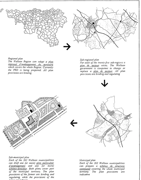
Walloon Region: All Acts, decrees and regulations concerning spatial planning applicable to the Walloon Region have been codified and centralised into the 1984 Code Wallon d'Aménagement du Territoire, de l'Urbanisme et du Patrimoine (CWATUP).
The CWATUP abolished national planning and the plan général d'aménagement
(municipal land-use plan), and developed a two-tier system which concentrates on the regional and municipal level (see Table A5).
In November 1997 modification of the
CWATUP introduced the Schéma de dével-oppement de l'espace régional (SDER), a regional structure plan which intends to define strategic goals. Before these changes, a draft plan has already been drawn up
(Plan Régional d'Aménagement du Territoire wallon) (PRATW), although its future has not been determined yet. The project of PRATW
has pointed out three important planning aims: to promote the Walloon cities, to rede fine a territory and a way of life for the rural areas, and to design development projects for dynamic areas (aires de dynamique).
At the intermediate level the plans de secteurs have been retained, making them the highest planning level containing land-use regulations. At the municipal level the
plan général d'aménagement (municipal land-use plan) has been replaced by a
schéma de structure communal (municipal structure plan). This guiding document covers the whole municipal territory and de termines the conditions for municipal de velopment projects. It allows the municipality to understand its potentialities and weak nesses to define development priorities (see also Table A7). Similar to the Flemish Region and Brussels Capital Region, the Walloon Region also works with the plan particulier d'aménagement (particular land-use plan). The schéma-directeur (guiding structure plan) is a guiding document which amplifies the destination of part of a municipality and which can be considered as a kind of mini
schéma de structure communal.
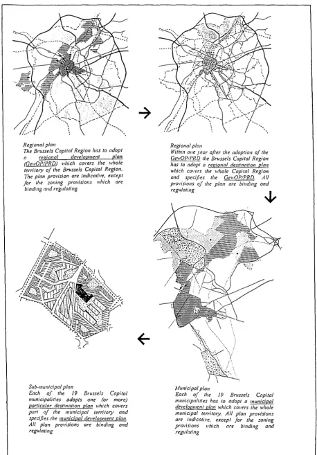
[image:32.595.88.542.599.756.2]Brussels Capital Region: The Brussels Capital Region has developed a two-tier system
Table A5. Planning system in the Walloon Region
Plan level Regional level Sub-regional level Municipal level Sub-municipal level Planning authority Regional government Regional government Municipal government Municipal government Municipal government Plan name
Walloon regional structure plan
(Schéma de Développement de l'Espace Régional)
Sub-regional plan
(plan de secteur)
Municipal structure plan
(schéma de structure communal)
Particular destination plan
(plan particulier d'aménagement)
Guiding structure plan
(schéma -directeur) Plan type Structure plan Land-use plan Structure plan Land-use plan Structure plan
(regional and municipal level). Two types of plans are provided, with no intermediate level: the development plan (ontwik-kelingsplan/'plan de développement) and the land-use plan (bestemmingsplan/plan d'affec-tation). Both tiers are to prepare both plans (see Table A6). At the regional level this results in a gewestelijk ontwikkelingsplan/plan régional de développement (regional development plan) and the gewestelijk bestemmingsplan/plan regional d'affectation du sol (regional destination plan). Similar plan types exist at the municipal level. The
gewestelijk bestemmingsplan/plan regional d'affectation du sol is similar to the Flemish and Walloon particular destination plan. The
gemeentelijk ontwikkelingsplan/plan commu-nal de développement (municipal structure plan) covers the whole municipal territory and is a structure plan containing development objectives, action schemes, priority areas and the general destination of the different areas
(see Table A7). It further contains regulations on aesthetics. The municipal plans have to be approved by the regional authorities.
The development plan acts as a general policy framework while the land-use plan specifies the land uses. Key priorities for spatial planning include housing and social policies for preserving a mixed population and social balance, policies for a mix of economic activities and environmental and transport policies to accommodate social and economic progresses without reducing the quality of life. In 1995 the regional development plan was adopted by the regional authorities. Currently the Brussels sub-regional plan still is being used until its replacement by the pending regional land-use (destination) plan.
[image:33.595.67.521.384.540.2]A20. A characteristic of the 1962 Spatial Plan ning Act was the lack of accordance between the
Table A6. Planning system in the Brussels Capital Region
Plan level
Regional level
Regional level
Municipal level
Sub-municipal level
Planning authority
Regional government
Regional government
Municipal government
Municipal government
Plan name
Regional development plan
(Gewestelijk ontwikkelingsplan/ plan Régional de développement)
Regional destination plan
(Gewestelijk bestemmingsplan/ plan Régional d'affectation du sol)
Municipal development plan
(Gemeentelijk ontwikkelingsplan/ plan communal de développement)
Particular destination plan
(bijzonder bestemmingsplan/ plan particulier d'affectation du sol)
Plan type
Structure plan
Land use plan
Structure plan
Land use plan
Table A7. Municipal plans in the Flemish Region, Walloon Region and Brussels Capital Region
Region
Brussels Capital
Flanders
(1962 legislation)(') Flanders
(1996 legislation) Wallonia
Covering the entire municipality Gemeen telijk On twikkelingsplan/ Plan Communal de Développement
(Municipal development plan)
Algemeen Plan van Aanleg(') (Municipal destination plan)
Gemeentelijk structuurplan
(Municipal structure plan)
Schéma de Structure Communal
(Municipal structure plan)
Covering only part of the municipality Bijzonder Bestemmingsplan/
Plan Particulier d'Affectation du Sol
(Particular destination plan)
Bijzonder Plan van aanleg (') (Particular destination plan)
Gemeentelijk uitvoeringsplan
(Municipal implementation plan)
Plan Particulier d'Aménagement
(Particular destination plan)
Schéma-directeur
(Guiding structure plan)
Refers to the old planning system.
[image:33.595.65.518.592.738.2]Table A8. Relationship between the political-administrative levels, planning levels and planning instruments
Political level
Belgium (federation) Region
Province
Municipality
Planning level
Belgium Region (3)
Planning region • Flanders (5) Sub-region • Brussels (1)
• Flanders (25)
• Wallonia (23)
Province • Flanders (5)
• Brussels Capital (0) • Wallonia (5) Municipality • Brussels (19) • Flanders (308)
• Wallonia (262)
Sub-municipality
Instruments
None
Regional structure plan • Brussels (1) • Flanders (1) * • Wallonia (1)
Regional destination plan • Brussels (1)
• Flanders (1) *
Regional plan Sub-regional plan • Brussels (1)
• Flanders (25)
• Wallonia (23
Flanders
• Provincial structure plan • Provincial destination plans
Brussels
• Municipal destination plan
Flanders
• Municipal destination plan • Municipal structure plan Wallonia
• Municipal structure plan Brussels
• Particular destination plan Flanders
• Particular destination plan • Spatial implementation plans Wallonia
• Particular destination plan
Status
None
Adopted (1995) Adopted (1997) In preparation
In preparation N/A
None
Adopted, will be replaced by the Regional destination plan
Adopted, some under revision
Adopted, some under revision
All in preparation
In preparation
Some adopted Some in preparation
Some adopted
Some adopted
Several adopted N/A
Several adopted
The number between (brackets) refers to the number of regions, sub-regions, etc.