Indicators of a Property Distinct from Density
Stephen Marshall1, Yi Gong2 and Nick Green3Abstract
The ‘compact city’ concept is prominent in contemporary policy debates about ideal or ‘sustainable’ urban forms. However, the property of compactness itself is not well defined. For example, compactness is sometimes confused or conflated with density (which itself has multiple interpretations); or it presented as the antithesis of sprawl (a concept that itself is not well defined).
This paper investigates the concept of compactness, and develops a general definition and specific indicators that can capture this property in the urban context. This provides an alternative to using density as a proxy for compactness in debates about possible ideal urban forms.
The paper first contextualises the urban compactness debate, and then reviews existing concepts of compactness. Then, the paper develops a new general conceptualisation of compactness, and specific indicators that allow quantification of compactness. It is suggested that urban compactness can usefully be quantified in relation to the reciprocal of urban diameter and perimeter, in a way that conversely can distinguish urban forms that are not compact, either by being elongated, straggling or dispersed. A variety of theoretical geometric shapes are used to demonstrate different degrees of compactness. Additional indicators such as building compactness and population compactness are also suggested. The paper then demonstrates the application of these compactness measures to a range of urban areas, to demonstrate the use of the different indicators, and these are also contrasted with corresponding measures of density. The paper concludes on the potential use and application of the compactness indicators and its possible contribution to the ‘compact city’ debate.
1 Bartlett School of Planning, University College London. Corresponding author:
1
Urban Compactness:
Indicators of a Property Distinct from Density
Stephen Marshall, Yi Gong and Nick Green1. INTRODUCTION
The idea of a compact city as an ideal city – or the ideal city as a compact city
– has a long tradition. Idealised cities of the Renaissance were often depicted as bounded polygons, with walled enclosure separating the urban from the rural surrounds. This kind of imagery has persisted with contemporary associations of ideal and compact cities4.
4 In a recent public lecture, Richard Rogers associated the Italian town of Pienza with
2 Historically, the compact city has not only been a Utopian ideal but a pragmatic one based on mathematics: walled cities of compact shape had the advantage of minimising the length of perimeter wall to enclose the maximum area of city (Barrow, 2008).
In contrast, much of city planning as a modern discipline has been concerned with reducing the overcrowding of the nineteenth century industrial city, in the quest for better living and housing standards. This implied less compactness: dispersion and reduced density, often entailing the provision of gardens (e.g. garden cities or garden suburbs) or landscaped open spaces.
The late twentieth century rise to prominence of the environmental movement and concern for sustainable development led to renewed favour for compact cities whose dense form could in principle minimise landtake and reduce travel distances. For example, in the UK the Urban Task Force generated a vision of compact, mixed use towns and cities (Urban Task
Force, 1999); and the Government’s Sustainable Communities programme proposed the construction of millions of new homes, not in isolation but
assembled in ‘communities’ or ‘settlements’ – and some in the form of ‘eco towns’ (ODPM, 2003, DCLG, 2007). These initiatives aimed towards the concept of 'sustainability' have received additional reinforcement by more recent initiatives that emphasise the need to avert or mitigate climate change.
Despite the customary advocacy for compact cities, many researchers and commentators have questioned some of the assumptions that underlie the concept, since compact forms of themselves do not necessarily result in ‘compact’ outcomes (e.g. travel-minimising behaviour). Compact cities in any case will not be optimal if they are not attractive to users; and ‘compact’ development deposited in an outer urban location will not necessarily perform like the equivalent compact core areas of traditional cities (Echenique et al., 2009).
Part of the problem with the compact city debate is that commentators may be arguing about different things, since there is not necessarily a
3 cities may be contrasted with alternative supposed ideal urban structures, such as 'polycentric' or 'public transport oriented' forms. But both ‘polycentric’ and ‘public transport oriented’ settlement patterns could also be interpreted as compact – depending on how each of these terms is defined.
In effect, there is no single consistently adopted means of
systematically specifying the concept of compactness across – and common to – the urban disciplines. Without systematic specification of urban patterns, the options for design may be limited to arbitrary stereotypes, and the
evaluation results are liable to be ambiguous or misleading. One cannot say
that the compactness is more desirable or less desirable than other urban characteristics (such as density, polycentricity, and so on) if compactness is not clearly defined in the first place.
As a result, a recent research project explored the concept of compactness and how this property might be captured and applied to
settlements.5
There are at least five reasons for exploring and attempting to capture
the property of compactness. First, it is an intuitively straightforward concept, understood by the general public in a variety of contexts, yet it could be interpreted and measured in different ways or degrees of resolution in the urban context. Second, compactness is (potentially) geometrically
straightforward – we can take the circle to be the maximally compact two-dimensional figure, and relate any other shape to this in comparison. Third, compactness relates to recognisable real-world policies – as with ‘Compact City’ policies. In other words, the idea of the Compact City is a well known and much debated issue of real significance to planners and practitioners, not just analysts of urban geometry. Indeed, compactness is one of the few
geometrically suggestive terms to feature in general planning policy literature. Fourthly, compactness relates meaningfully to operational performance issues to do with ‘distance from everywhere to everywhere else’, and hence issues of efficiency, energy consumption, ‘sustainability’ and so. Finally, compactness
5 The SOLUTIONS project (Sustainability Of Land Use and Transport In Outer
4 is often associated with density, but it is argued that these concepts are not equivalent; and confusion of the two can give rise to confusing results and interpretations of the benefits or otherwise of density or compactness.
Specifically, the scope of the research reported here is to support the clearer specification of the property of compactness (as distinct from density), to allow this to be used in testing and evaluation of urban forms, not to make a
priori assumptions about whether compactness is ultimately a desirable
property or not.
This paper is organised in the following sections. Following this
introduction, section 2 reviews existing conceptions of compactness, as found in the academic and policy literature, including its association with density in the compact city policy debate. Then, in section 3, we develop indicators of compactness, and illustrate this with reference to some theoretical geometric shapes. After this, in section 4 some illustrative examples are used to
demonstrate the application of these indicators to selected settlements. Finally, we draw conclusions on the potential use of such compactness
indicators, in future urban analysis and policy debates.
2. CONCEPTIONS OF COMPACTNESS
2.1 Why 'Compact City'?
'When you rebuild on a large scale, what you do in effect is to scoop out the centre of the town and re-distribute it on the outskirts.' Thus George Orwell in
The Road to Wigan Pier (Orwell,, 2001), in an unwittingly prescient summary
5
Take the question of overcrowding, for instance. Quite often you have eight or even ten people living in a three-roomed house. One of these rooms is a living-room, and as it probably measures about a dozen feet square and contains, besides the kitchen range and the sink, a table, some chairs and a dresser, there is no room in it for a bed. So there are eight or ten people sleeping in two small rooms, probably in at most four beds. If some of these people are adults and have to go to work, so much the worse.
…Then there is the misery of leaking roofs and oozing walls, which in winter makes some rooms almost uninhabitable. Then there are bugs. …There is no way of exterminating them (Ibid.: 53).
Even by the 1930s, there was a already a view that precious
countryside and agricultural land was being needlessly lost to speculative ribbon development, and through a series of reports and statutes assembled
over a period of a decade and a half or so, the modern British planning system was ushered in during the years after the second world war (Hall, 1988). The containment of urban sprawl was, and remains, a central part of that system; the notion of the ‘compact city’ has arisen in the last decade or so by way of a counterpoint to the notion of urban sprawl. To put it bluntly, the compact city ideal attempts to offer a direct and overt challenge to the
perceived problems brought about by the long-held English preference for a suburban lifestyle (Power, 2001).
As Neuman points out, however, it is a concept that always seems slightly unsure of itself: there is a preponderance of question marks in the titles of articles dealing with the compact city (Neuman, 2005).
The problem is that many of the merits of urban intensification and the compact city have been based on assertion and theory rather than empirical evidence, according to several authors (Breheny, 1992; Jenks, Burton, et al., 1996; Williams, 2000; Williams, Burton, et al., 2000; Vallance, Perkins, et al., September, 2005). To be sure, city centre ‘loft living’ of the kind identified nearly three decades ago by Zukin (1982) is still a preference for a significant minority, but it is not without its problems. One’s sense of privacy, for
6 community (Breheny, Gent, et al., 1993). And, in England at least, there is a strong and deep-rooted preference for a more suburban lifestyle (Rasmussen, 1982; Champion, 1989; Breheny, 1997; Breheny & Hall, 1999; Champion, 2001).
The compact city as a notion has been championed above all by Richard Rogers and Anne Power, who have argued that ‘people gravitate to compact cities because they like its energy, opportunity, diversity and
excitement’ (Rogers & Power, 2000; Power, 2001). Power argued that were housing development to match the densities of Georgian development — she doesn’t specify a size of Georgian house — then there would, in 2001, have been no need for any new housing development to be on greenfields: it could all have been catered for through urban infill schemes and densification (Ibid.). For this to happen would require that supply and demand match one another, in terms of the quantity, type and location of housing; the problem is,
they do not match. The excess supply, broadly, is in the north of the country, whereas the demand is in the south (Arup, 2005). So even if we accept that
the compact city is an idea worth pursuing, we need to acknowledge that it may, in some circumstances, be as much a matter of regional and national economic policy as it is of urban policy.
2.2 Measuring 'Compactness'
7 More importantly for the immediate dialogue however, is that there is no single coherent discussion of compactness in the literature. Perhaps the closest approach is “Quantifying Urban Form: Compactness versus ‘Sprawl’” (Tsai, 2005). The perspective is a US one, and so does not directly relate to the contemporary UK debate, but of more interest here is the fact that it attempts to develop a formal approach to analysing and understanding compactness. Their approach adopted is to use established indices as the basis for their approach. Three co-efficients were tested using both computer simulations of urban form and empirical data (Ibid.). First was the Gini
coefficient, which was tested as a means of differentiating between degrees of equal population or employment distribution; second were the Moran and Geary coefficients, which were tested as means of differentiating between degrees of clustering of population or employment. All were found to be flawed in some way or another.For example, the Gini coefficient, in this
context, gave little clue as to whether the urban form might be monocentric, polycentric or simply dispersed and spread out (Ibid.). The Geary coefficient
was no better; as with the Gini coefficient, this yielded identical values for different forms. The Moran coefficient performed better in the simulations, enabling a reasonably clear differentiation between different urban forms: but none was perfect (Ibid.). These coefficients were all calculated on the basis of the relationship between where people lived and worked, and so tended to overlook natural areas, or the ‘spatial in between’ as Green has called it (2008). Tsai goes on to point out that the definition of the metropolitan area is crucial to such endeavours, and concludes by noting that if we wish to
understand the role of metropolitan form on travel behaviour, then including all elements of the metropolitan area is crucial (Ibid.). The present paper, inter
alia, attempts to follow up on Tsai’s observation.
8 compactness has been handled in urban debates, we too must follow the commentators and examine notions of density.
In a paper called “Measuring Urban Compactness in UK Towns and Cities” (Burton, 2002) Elizabeth Burton notes that there are various ways of defining both urban compactness and urban density; but none of them is completely satisfactory.
The compact city itself is a contested notion, and so compactness can be defined in terms of how well connected it is: in other words, it could be physically diffuse, but ‘compact’ in the sense that travelling around it is quick and easy (Ibid.). Burton goes on to point out an even looser definition of compact (self-contained) before noting that in the UK context, compact carries a less abstract and more literal interpretation: the compact city is a moderately sized ‘free-standing, [self-]contained urban settlement’ that is nonetheless ‘large enough to support the whole range of services and
facilities’ (Ibid.:220).
Density garners more coverage, not least because it is a less abstruse
concept than compactness: crudely, it is simply a measure of how many things are in a particular space. The problems come when we start trying to explain what we mean by ‘thing,’ and what we mean by ‘space.’
9 concentrated on sub-centres rather than being spread uniformly across the city. Such efforts may also involve developing at higher densities (Ibid.).
When it comes to actually measuring compactness, it turns out that most measures relate to density. In other words, density becomes a proxy for compactness, a crucial point for this paper, since we are arguing that
compactness can be measured independently of measures of density. A good starting point in any discussion of urban density is the
difference between net and gross residential densities. The Town and Country Planning Association’s policy statement on residential density offers these definitions (TCPA, 2003):
Net residential densities refer only to the land covered by the residential development, with any gardens and other spaces that are physically included in it, and usually half the width of any adjacent roads. Gross residential densities also include certain nearby non-residential development, in order to reflect the amount of services and amenities such as schools and parks that are needed to support the housing element. Although the distinction between net and gross appears straightforward, in practice different inclusions in each category can complicate otherwise simple comparisons (Ibid.).
As the TCPA suggest, comparisons are not straightforward. For example, net residential density may be measured in terms of dwellings per hectare, or bedrooms per hectare, or people per hectare. The important thing is that all terms are clearly defined and explained. For example, identical figures for people per hectare in two different areas could mask the fact that in one area, those people are living in self-contained flats, whereas in the other area people could be sharing a house. Equally, a given number of dwellings per hectare says nothing about the number of people per hectare. In practice, then, we need more than one measure; and here, we are still simply
discussing net residential density.
In an earlier paper, Burton suggests a number of different density,
10 most settlements have (Ibid.). In this schema, urban form is considered in terms of the density of built form or of population; or of variety and proximity of facilities. Crucially, the actual shape of a place is not mentioned, so in
principle, a round settlement and a linear settlement having identical areas and identical suites of indicators would be registered as equally compact, even though traversing the two settlements would take different lengths of time. A round settlement 5 kilometres in diameter would have an area of just under 20 square kilometres, and would take about an hour to cross in any direction at normal walking pace. A linear settlement of half a kilometre wide by 40 kilometres long would have the same area, the same residential density, the same mix of uses and the same accessibility of different
amenities. However, it would take only a few minutes to walk from one side to the other, and half a day to walk from one end to the other. The settlements would measure identically in terms of compactness, however.
It is this paradox that lies at the heart of the analytical techniques outlined in this paper. And, as with other investigations into urban shape and
pattern, there can be a problem in that intuitively held concepts may be difficult to pin down precisely quantitatively, while indicators that can be objectively and quantitatively expressed and extracted from maps and datasets may be difficult to relate to the intuitively understood concepts they are intended to capture (Marshall, 2005, after Lord and Wilson, 1984).
11 3. COMPACTNESS PROPERTIES AND INDICATORS
3.1 Introduction
This section demonstrates an interpretation of compactness and illustrates this with reference to some theoretical geometric shapes. It then proposes a range of alternative variations of compactness, which might be used to capture different aspects of the basic property of compactness.
3.2 Interpreting compactness
We can better understand the nature of compactness by considering three different ways of not being compact. In each case this relates to the outline shape of the built-up area.
The first way of not being compact, it is suggested, is by being in some way elongated, such that diameter is relatively large relative to area enclosed.
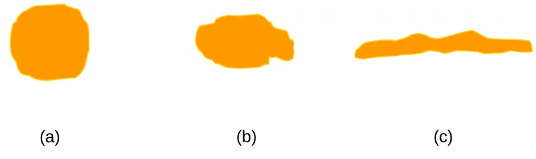
Figure 1 demonstrates graphically how we could set out an intuitively easily understood gradation from more compact to less compact forms, ranging from
a roughly circular form to an elongated or linear form.
[image:12.595.119.500.465.578.2](a) (b) (c)
Figure 1. Gradation from most compact (a) to least compact shapes (c). The shape under consideration is the boundary of the built-up area. For roughly
the same area and perimeter, the diameter increases markedly from (a) to (c).
12
(a) (b) (c)
Figure 2. Gradation from most compact (a) to least compact shapes (c). For roughly the same diameter and almost the same area, the perimeter
increases substantially from (a) to (c).
A third way of being not compact is the state of being dispersed or scattered. This implies the condition of being a distribution of separate forms over a wide area. Figure 3 suggests a spectrum from more compact to more dispersed, where greater dispersal implies the scattering into more and smaller units. This means, in effect, that there are both high values of diameter and perimeter relative to area.
(a) (b) (c)
Figure 3. Gradation from most compact (a) to least compact shapes (c), a spectrum from compactness to dispersal.
13 3.3 Quantification of compactness
3.3.1 Compactness indicator
Implicit in the foregoing demonstrations are the following observations:
• compactness seems to be related to minimising diameter relative to area;
• compactness seems to be related to minimising perimeter relative to area;
• the circle is the most compact form.
Hence a potential quantitative indicator for compactness is to define compactness as follows:
Compactness
DP A
C = 4 [Equation 1]
Where
C = compactness
A = area
D = diameter
P = perimeter
By this indicator, a circle has a maximum compactness equalling unity:
0 . 1 2 . 2 4 4 2 = = = r r r DP A C
π
π
[Equation 2]14
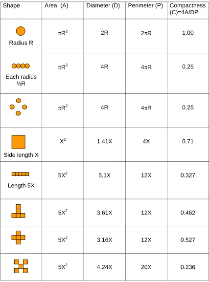
Table 1. Examples of compactness values for different geometric shapes Shape Area (A) Diameter (D) Perimeter (P) Compactness
(C)=4A/DP
Radius R
πR2 2R 2πR 1.00
Each radius ½R
πR2 4R 4πR 0.25
πR2 4R 4πR 0.25
Side length X
X2 1.41X 4X 0.71
Length 5X
5X2 5.1X 12X 0.327
5X2 3.61X 12X 0.462
5X2 3.16X 12X 0.527
15 So far, this indicator of compactness relates only to a given bounded area under consideration, which in the urban context means the ‘footprint’ of the built-up area. Clearly this is only a two-dimensional measure. It is possible imagine a volumetric equivalent, whereby the volume of a sphere had
maximum compactness. However, this is less useful for urban compactness, since a sphere is not a realistic form for an urban area to aspire to, in the way that a circle works for the theoretical two-dimensional situation. This is not least because urban areas are composed of discrete buildings, that are generally not connected to each other except via the ground plane (Marshall, 2009). In this sense a cylinder would make a better proxy for a pure geometric model of compactness. In this case, there would be a trade-off between
having a cylinder that was too tall (implying too great a distance to reach the ground) and one too spread out (implying too great distances along the ground). For this measure, the number of storeys or absolute height would
need to be known in principle for each building, and the actual built envelope compared against a theoretically most compact envelope. Instead of pursuing
these, an alternative is to create an indicator of compactness that also builds in the extent to which a ‘built-up area’ is actually built up.
3.3.2 Built compactness
We can therefore define a property of built-compactness, or B-compactness, that equates with the building density multiplied by the compactness; where building density is the proportion of a given area that is actually built up (or occupied by building footprints), i.e. B/A. Hence:
Built compactness
DP B DP
A A B C A B
CB = = • 4 = 4 [Equation 3]
Where
CB = built-compactness or B-compactness
16 This version of B-compactness will give a more three-dimensional feeling of compactness, than the original area-based version of compactness (which we could refer to as A-compactness) because it takes account not only of
properties associated with the two-dimensional boundary, but also the third dimension through what is built ‘up’ on it.
3.3.3 Further interpretations of compactness
It is interesting to note that we can see in retrospect that with the suggested definition of A-compactness (4A/DP), compactness is actually directly
proportional to area, How might this proportionality of compactness and area be resolved, when intuitively we might expect something compact to occupy less area (and hence expect that compactness would be inversely related to area)?
The answer suggested is that the fundamental sense of compactness is captured in the denominator: compactness represents ‘something’ divided
by the product of diameter and perimeter. This is equivalent to the way that there are many indicators and manifestations of density, but that the
fundamental sense of density is to do with ‘something’ divided by area – for example, population density or employment density.6 In these manifestations of density, we could have any parameter on the numerator, and as long as area is on the denominator, then the whole indicates some kind of density. By extension, we could have any property divided by the product of diameter and perimeter, and call that property some kind of compactness. Hence while population density would equal population divided by area, population
compactness (CP) would relate to population divided by the product of perimeter and diameter. Employment compactness (CE) would relate to
employment divided by the product of perimeter and diameter (Equations 4, 5). Finally, we could posit a property of floorspace compactness (CF) relating
to floorspace divided by the product of perimeter and diameter (Equation 6).
6 This is referring to the urban and geographical contexts of properties such as
17
Population compactness
DP I
CP = 4 [Equation 4]
Where
CP = population compactness
I = number of inhabitants within given perimeter P
Employment compactness
DP E
CE = 4 [Equation 5]
Where
CE = employment compactness
E = number of employees within given perimeter P
Floorspace compactness
DP F CF
4
= [Equation 6]
Where
CF = floorspace compactness
F = total floorspace (area) within given perimeter P
What the original definition of compactness (A-compactness) does is to make
area itself the quantum that is fitted into a given perimeter and diameter. This
18 be directly proportional to area; where area is in effect a proxy for some urban quantity to be accommodated within a given footprint. In effect, the positive sense of compactness is not just about internal distance-minimisation, but also about minimising the impact of the urban footprint, in terms of minimising perimeter and diameter. This interpretation of compactness also fits well with the intuitive sense it is applied as a virtuous property in various walks of life, where compactness may be associated virtuously with something ‘small on the outside, big on the inside’.
A conclusion here is that compactness can be understood to be directly proportional to area, rather than being inversely proportional to area, as
density is. This, for sure, indicates that compactness (as defined here) is quite distinct from density. Indeed, we can see that compactness is not just another one of a plethora of variants of density, but is a quite distinct property, with its own corresponding plethora of variants.
The indicators of compactness are now illustrated by application to selected settlements in England.
4. APPLICATION TO URBAN AREAS 4.1 Initial illustration
The UK 2001 Census provides the most suitable data source here, based on the definition of an English urban area as ‘an area of urban land use of 20 hectares or more with 1,500 or more residents.’7 In other words, ‘urban areas’ here are actually based on density, rather than administrative boundaries.
Figure 4 (b) displays the Cambridge Urban Area (in white) on top of the
Google Map (a). The boundary of the Cambridge urban area can be seen to lie nicely with its built-up area, especially in Figure 4 (c).
7 English Urban Areas, 2001 from Edina UKBorders
(https://www.census.ac.uk/search/Full_display.aspx?id=1081)
19 a) Google Map around Cambridge
20 c) Close up to Cambridge Airport
Figure 4 Cambridge Urban Area shown in Google Map
4.2 Compactness for a range of English urban area
Figures 5 and 6 show compactness values for a range of English urban areas.
As can be seen from Figure 5,the urban area ofLoughborough (a) is intuitively more compact than Weymouth (b); and the compactness values
[image:21.595.90.500.477.690.2]bear this out (24.5% versus 6.9%). In this case Weymouth is less compact both by being elongated and straggling, and being dispersed into 5 separate urban area ‘blocs’ (polygons).
21 (a) West Yorkshire (0.029)
(b) Longton (0.032)
(c) Beverley (0.312)
(d) Wansford (0.675)
(e) Wells 0.722)
22 In Figure 6, a spectrum of settlement areas is presented; the most compact of the urban areas in England is Wells (0.72), and the least compact is the West Yorkshire urban area (0.03).
As one can infer from Figure 6, some of these values of compactness may be somewhat artificially dependent upon the way the urban area
boundaries are drawn as polygons. However, this arguably goes for any data relating to any ‘artificial’ cartographic features such as boundaries. The
demonstration nevertheless shows in principle the intuitive sense in which the property of compactness is captured: in Figure 6, shape (e) is clearly
intuitively more compact than (a) or (b), however those shapes were arrived at or whatever they are representing in detail.
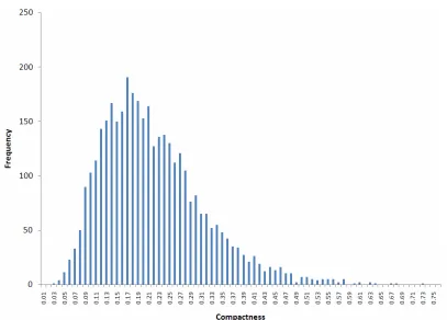
Figure 7 shows the values of compactness for 3,701 urban areas in England. The mean compactness of all 3,701 urban areas in England is 0.21 (SD 0.097), which is larger than the median (0.20). The distribution has a
positive skew; a large number of urban areas have relatively low
compactness, and only a small number of urban areas are highly compact.
Incidentally, it may be noted that in some cases there is a tendency for an increase in the size of an urban area to be associated with a decrease in the compactness. That is to say, larger urban areas tend to be less compact compared with smaller urban areas. This may be explained by the fact that urban areas tend to be built of relatively small units (e.g. buildings) that do not significantly or systematically increase in size with settlement size. It is ‘easy’ for a building footprint to be rectangular or square (or even circular) and hence be relatively compact; but an aggregation of buildings, as more
23 Figure 7. Frequency distribution of compactness values for 3701 English urban areas.
4.3 Built-compactness
As suggested earlier, we can generate an indicator of built-compactness (or B-compactness) by multiplying the area-compactness by the proportion of the area actually occupied by buildings (Equation 3). These values can be
compared with density values for the same set of settlements.
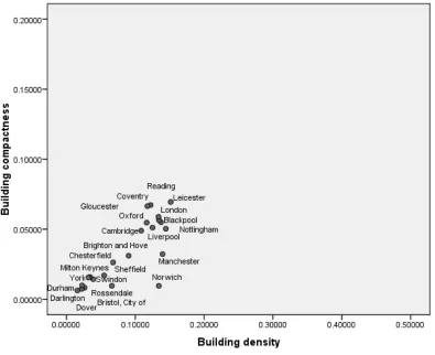
As a preliminary analysis on this front, Figure 8 shows built
[image:24.595.90.497.66.358.2]24 Figure 8 Building density vs built compactness
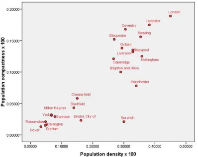
4.4 Population Compactness
25 Figure 9 Population density vs population compactness
A semblance may be noted between the charts in Figure 8 and 9, in that the gradient of any line from the origin to any point is the same in both cases. The gradient is in fact equivalent to the A-compactness, i.e. 4A/DP:
For Figure 8:
C DP
A B A DP
B A B DP
B x y
Gradient = = 4 ÷ = 4 • = 4 = [Equation 7]
For Figure 9:
C DP
A I A DP
I A I DP
I x y
Gradient = = 4 ÷ = 4 • = 4 = [Equation 8]
26 4.5 Sensitivity to boundaries
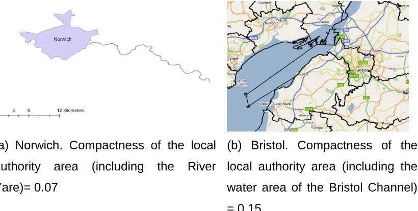
Compactness values are sensitive to the way that boundaries are drawn. For example, the area around the River Yare was included as a part of Norwich (see Figure 10a). Two islands (Flat Holm and Steep Holm) in the Bristol Channel, and a large area of water between the islands and Bristol coast line, were included as a part of Bristol as shown in Figure 10 (b). The resulting compactness measure was significantly lower due to the inclusion of these outlying features because the physical shape of the city itself was stretched. This suggests that defining boundaries correctly is crucial when measuring compactness.
(a) Norwich. Compactness of the local authority area (including the River Yare)= 0.07
(b) Bristol. Compactness of the local authority area (including the water area of the Bristol Channel) = 0.15
Figure 10 Cases where boundary anomalies affect the interpretation of
compactness
The Bristol and Norwich cases demonstrate one of the problems of attempting to use compactness as applied to an administrative area. The sensitivity to boundary conditions could make compactness seem more problematic than density, but yet we can use this to help understand the difference between compactness and density.
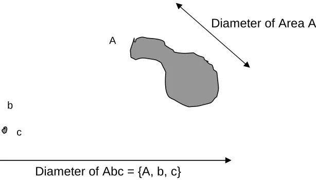
[image:27.595.96.506.297.504.2]27 50% (assuming the area and perimeter increases are negligible, but the diameter of Abc is roughly double that of A).
This sensitivity of compactness to what is included within the boundary helps to illustrate the true nature of the indicator, which is perhaps the actual true meaning of compactness. So for example the compactness of Abc really
is substantially different from A – and ought to be seen to be – while the area
[image:28.595.117.424.232.407.2]or average density of Abc and A may be very similar.
Figure 11. Demonstration of the effect of including outlying areas 'b' and 'c' together with area A. (Based on the Bristol case) The diameter of Abc is roughly double the diameter of A, whereas the increase in area and perimeter (from A to Abc) is practically negligible, so the compactness of {Abc} will be roughly half that of A.
4.6 Wholes and parts
We can also note another geometrically significant difference between compactness and density. Areas are simply additive, such that the weighted average of the densities of two or more separate areas will equal the density of the sum of the areas. So in the above example (Figure 11):
• the Area Abc is the sum of the areas A, b and c, i.e. Abc = A + b + c.
• the density of Abc will equal the weighted average of the densities of A, b and c.
• but the compactness of the total area (Abc) will not equal the sum of the compactness values of A, b and c.
A
c b
Diameter of Abc = {A, b, c}
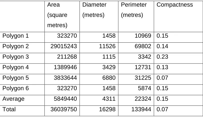
28 This may be illustrated explicitly with reference to the Cambridge case. The average of compactness of all components is different from the compactness of the whole. The Cambridge urban area has 6 individual polygons as shown in Figure 12, of which compactness varies from 0.07 to 0.23, with an average compactness of 0.15. However, the compactness of Cambridge urban area as a whole is 0.07, which is substantially different from the average
[image:29.595.123.474.278.678.2]compactness. This contrasts with the density, as the average density of individual part is similar to the density of the whole (Table 2).
29 Table 2. Breakdown of compactness values by polygon.
Area
(square metres)
Diameter
(metres)
Perimeter
(metres)
Compactness
Polygon 1 323270 1458 10969 0.15
Polygon 2 29015243 11526 69802 0.14
Polygon 3 211268 1115 3342 0.23
Polygon 4 1389946 3429 12731 0.13
Polygon 5 3833644 6880 31225 0.07
Polygon 6 323270 1458 5874 0.15
Average 5849440 4311 22324 0.15
Total 36039750 16298 133944 0.07
A potentially interesting point following from this is that compactness seems to need to relate to a whole object for it to have meaning. Perhaps compactness must be a property of the whole, that cannot be applied to a sample part. For example, we can take a sample area d from city D, where the overall city D is not compact, but the sample area d could be perfectly compact. Conversely, we can take a non-compact sample area e from a compact city E (Figure 13).
.
Figure 13. Sample areas d, e cut out from overall urban areas D, E. D
d
E
[image:30.595.107.459.517.695.2]30 This situation is different from density, in the sense that if D is dense overall we would expect d to be dense too, and similarly for E and e. Put another way, we would not expect a sample d or e to be affected by the way the boundary of the sample was drawn – unless sample boundaries are in practice drawn in such a way as to deliberately capture areas of homogenous density, e.g. draw a boundary around a particular low-density or high-density development (e.g. tenemental housing or detached villas) . But in this case, it is not the shape of the boundary that is affecting the value of density directly, but the way the boundary is drawn so to enclose a particular kind of urban character or density.
As noted, the sensitivity of compactness to boundary conditions could be seen as a weakness (of compactness as a measure, compared with
density), except if we consider that the indicator is faithfully capturing what we really intuitively mean by compactness. In this sense, areas A, b, c, d and E really are rather compact, whereas Abc, D and e really aren’t (Figures 11, 13). In each case, compactness is a property of the whole.
This reinforces the idea that compactness is indeed different from density, and that when urban theorists call for cities to be compact and/or dense, they are meaning (at least) two different things: one, that cities should have a high-density fabric (e.g. townhouses, tenements, terraces, etc), and the other that they should be relatively speaking clearly bounded, like a classic walled city, and not straggling or dispersed.
5. CONCLUSIONS
31 Because of the way compactness is defined, this property is clearly distinct from density. Indeed, whereas density is inversely proportional to area, A-compactness is actually proportional to area. Moreover, density can be seen to be a measure that can be 'sampled’ or taken out of context, within an urban area, whereas compactness is best interpreted as a property of a given area-shape as a whole.
This means that we could have urban areas that are compact but not dense, or dense but not compact, as well as cases where density and compactness are positively associated. This suggests that compactness, as presented here, could be considered a specific contribution to the better articulation of urban pattern properties as part of the ‘compact city’ debate.
Clearly, compactness is sensitive to boundary conditions. This is partly because compactness relates to a boundary as a whole, and so a deviation in a boundary that did not have much effect on area (and hence density) could
affect the perimeter or diameter (and hence compactness). Compactness is also sensitive to the scale at which a boundary is measured. A crudely
approximated boundary would be expected to have greater compactness than a detailed boundary measurement that took in every small deviation, hence lengthening the perimeter, and reducing compactness.
But perhaps the main thing is simply to draw attention to the basic conceptual difference between compactness and density. This is analogous to the way in which we may often talk loosely of ‘green land’ but can more
usefully distinguish conceptually between 'green belt' land and 'greenfield land' (e.g. brownfield land may be found in the green belt). Even if it were to turn out that most arguments in the compact city debate really do intend to engage with density rather than compactness, it still seems useful to be able to focus the debate in those terms, and reserve for more specific attention those parts of the debate concerned with the shape of cities – which could for example be a debate about roughly round settlements with clear boundaries (which could nevertheless be of relatively low density), versus linear or ribbon development (which could have high density).
32 interpretations and formulations demonstrated herein should allow both
researchers and policy-makers to better articulate the concept of compactness. For example, if policy-makers should wish to develop a ‘compact city’ policy, then reference to the different manifestations of compactness herein may assist in this – over and above conventional conceptions of compact cities typically associated with density.
The study here has naturally been limited in the range of compactness indicators explored, and settlements applied to. It naturally points towards further study on a variety of fronts:
• The expansion of the application of compactness to settlements with fuller empirical investigations and comparative studies, including comparison with other urban form variables such as density or polycentricity; and also sensitivity testing, to understand for example, the sensitivity of compactness to settlement size, and issues such as scale of measurement and fractal dimension;
• The extension of compactness interpreted in the third dimension of the urban fabric, including potential application to the compactness of buildings;
• The consideration of the performance of urban areas of different degrees of compactness, such as relating compactness to travel distance, transit orientation, energy use, and so on.
In terms of implications for the compact city policy debate, we suggest that compactness must be properly defined and addressed if policies for
compactness are to be robustly based on a combination of empirical evidence and conceptual clarity. Pursuing density rather than compactness could be mistaken, if density is not the beneficial ‘active ingredient’ it is sometimes supposed to be. Either compactness or density could be desirable, in
33
REFERENCES
Arup (2005) Regional Futures. Ove Arup & Partners Ltd.
Breheny M. (1992) "The Contradictions of the Compact City: A Review. " In: Breheny M, (ed) Sustainable Development and Urban Form. London: Pion. p.138-159.
Breheny M, Gent T, and Lock D. (1993) Alternative Development Patterns:
New Settlements. London: HMSO.
Breheny M, and Hall P. (1999) The People: Where Will They Live? London: Town & Country Planning Association.
Breheny M. (1992) Sustainable development and urban form. London: Pion. Breheny M. (1997) The People: Where Will They Work?. London: Town &
Country Planning Association.
Barrow, J. D. (2008) The importance of being peripheral, lecture at Gresham College, November 2008. Transcript at:
http://www.gresham.ac.uk/event.asp?PageId=108&EventId=808 (accessed 1st July 2010).
Burton E. (2000) The compact city: just or just compact? a preliminary analysis. Urban Studies. 37(11):1969-2000.
Burton E. (2002) Measuring urban compactness in UK towns and cities.
Environment and Planning B. 29(2):219-250.
Champion AG. (1989) Counterurbanization in Britain. Geographical Journal.
155 52-9.
Champion AG. (2001) A Changing Demographic Regime and Evolving Polycentric Urban Regions: Consequences for the Size, Composition and Distribution of City Populations. Urban Studies. 38(4):657-677.
Routledge.
DCLG (2007) Eco-Towns Prospectus. London: Department of Communities and Local Government.
34 Frey, H. (1999) Designing the City. Towards a More Sustainable Urban Form.
London: Routledge.
Green N. (2008) City-States and the Spatial In-between. Town & Country
Planning. 77(5):Town & Country Planning Association.
Hall P. (1988) Cities of Tomorrow. Oxford: Blackwell.
Hazewinkel M. (2002) Encyclopaedia of Mathematics. Berlin: Springer-Verlag. Jenks M, Burton E, and Williams K. (1996) The Compact City: A Sustainable
Urban Form?. London: E & F N Spon.
Lindsay M, Williams K, and Dair C. (2010) Is There Room for Privacy in the
Compact City? Built Environment. 36(1):28-46.
Lord, E. A. and Wilson, C. B. (1984) The Mathematical Description of Shape
and Form. Chichester: Ellis Horwood.
Marshall, S. (2005) Streets and Patterns. London and New York: Spon Press. Marshall, S. (2009) Cities, Design and Evolution. London and New York:
Routledge.
Neuman M. (2005) The Compact City Fallacy. Journal of Planning Education
and Research. 25(1):11-26.
ODPM (2003) Sustainable Communities: Building for the Future. London:
Office of the Deputy Prime Minister.
Orwell. (2001) The Road to Wigan Pier. London: Penguin Classics.
Power A. (2001) Social exclusion and urban sprawl: is the rescue of cities possible? Regional Studies. 8(1):731-742.
Rasmussen SE. (1982) London, the unique city. Cambridge, Massachusetts: The MIT Press.
Rogers R, and Power A. (2000) Cities for a small country. London: Faber and Faber.
TCPA (2003) Residential Densities – Policy Statement. London: Town & Country Planning Association.
Tsai YH. (2005) Quantifying urban form: compactness versus ‘sprawl’. Urban
Studies. 42(1):141-161. Routledge.
Vallance S, Perkins HC, and Moore K. (2005) The results of making a city more compact: neighbours' interpretation of urban infill. Environment
35 Williams K, Burton E, and Jenks M. (2000) Achieving Sustainable Urban
Form?. London: E & FN Spon.
Williams K. (2000) "Does Intensifying Cities Make them More Sustainable? " In: Williams K, Burton E, and Jenks M, (eds) Achieving Sustainable
Urban Form. London: E & FN Spon. p.30-45.