MAPPING RUDERALITY: heading for design
Susan Anne Christmas
BLArch (Hons), MArt
Submitted in partial fulfilment of the requirements for the Degree of Master of Fine Arts in the University of Tasmania
___________________________________________________________________________________
CANDIDATE DECLARATION
This thesis contains no material which has been accepted for a degree or diploma by the University or any other institution, except by way of background information and duly acknowledged in the thesis, and to the best of my knowledge and belief no material previously published or written by another person except where due acknowledgement is made in the text of the thesis, nor does the thesis contain any material that infringes copyright.
Signed:
Date:
AUTHORITY OF ACCESS
This thesis may be made available for loan and limited copying in accordance with the Copyright Act 1968.
Signed:
___________________________________________________________________________________
ABSTRACT
A newly acquired property in the Tamar Valley prompted the research, Mapping ruderality: heading for design. With ownership comes a natural inclination to make change, to imprint one’s mark on the land. In order to inform decision‐making and to maximize understanding of this new place called home, my research maps the cultural and natural phenomena of the site and its surrounds as a direct response to prevailing concerns. Working at the interface of art and design, one informs the other, setting the conditions for change.
___________________________________________________________________________________
ACKNOWLEDGEMENTS
My sincere thanks go to Penny Mason and Dr Deborah Malor for their guidance and support throughout the research project. Professor Marie Sierra, Dr Troy Ruffels and Dr Wayne Hudson have offered valuable advice when requested. Thanks also to Jane Emery for proof‐ reading the exegesis, and to Bruce Nye, John Wagg and Robert Boldkald for helping to prepare, transport and install work. Patrick Sutczak and Lynne Larby contributed photographic records of the assessment exhibition.
___________________________________________________________________________________
TABLE OF CONTENTS
Candidate declaration i Authority of access i Abstract ii Acknowledgements iii Table of contents iv List of figures v Introduction unfolding the chart 1 Chapter one circling the hermeneute’s hell 6 Chapter two plotting and scheming 9 Chapter three triangulating the practices (theirs with mine) 24 Chapter four grid unlocked 31 Conclusion squaring off 50 References 52 Bibliography 55
Appendix examination exhibition documentation
___________________________________________________________________________________
LIST OF FIGURES
Images are by the author unless otherwise stated.
Figure 1 Territorialising, 2010...3
Figure 2
Profiling, 2010...3
Figure 3
Hermeneutic Circle n.d. ...7
Figure 4
Persuading, 2010 ...10
Figure 5 Guy Debord, Discours sur les passions de l'amour, 1957...11
Figure 6 Julie Mehretu, Looking back to a bright new future, 2003 ...11
Figure 7 Ed Ruscha, Where are you going, man? Do you dig me?, 1985...12
Figure 8
Plan of Cosa, Italy, 273 BC...13
Figure 9
Schematic plan of Chandigarh, India, 1951...14
Figure 10 Orchard sites on River Tamar, 1904...14
Figure 11 Conversion Plan P125535, 1996 ...15
Figure 12 West Tamar residential development, 2010...15
Figure 13 East coast of Jave la Grande (Australia) in the ‘Vallard’ atlas, 1547 ...16
Figure 14 Ed Ruscha, Sunset/P.C.H., 1998 ...16
Figure 15 Paul Carter, Nearamnew (details), 2003...17
Figure 16 Conversion converted, 2010...18
Figure 17 David Jones, Soulèvement – triangulaire, point de vue (2), 2003 ...19
Figure 18 James Turrell, Roden Crater, 1992 ...20
Figure 19 Buckminster Fuller working on his Dymaxion Projection, 1943...21
Figure 20 Jasper Johns, Ocean, 1996 ...21
Figure 21 Mel Chin, Revival Field, 1990 ...22
Figure 22 Janet Laurence, Forensic sublime: crimes against the landscape, 2008 ...25
Figure 23 Fujiko Nakaya, Fog sculpture #94925, 1976...26
Figure 24 Julie Mehretu, Inkcity (small 3), 1996 ...27
Figure 25 Julie Mehretu, Untitled, 2000 ...27
Figure 26 Anne Wilson, Portable city, 2008...28
Figure 27 Anne Wilson, Topologies (3‐5.02), 2002‐ongoing...28
Figure 28 Maya Lin, Wave field, 1993‐95...29
Figure 29 Maya Lin, Wire landscape, 2006 ...29
Figure 30 Maya Lin, Untitled (plaster relief landscapes), 2005...29
Figure 31 Cracked, 2009 ...33
Figure 32 Map of Tamar River, West Arm, n.d. ...33
Figure 33 Mud ‘rubbish’ brick, July 2010 ...33
Figure 34 Heavy at times, contracting to the east, 2011 ...34
Figure 35 Pegging out, 2011 ...34
Figure 36 Rubbing and staining, 2009 ...35
Figure 37 Impressions, 2009 ...35
Figure 39 Repetition, 2009...36
Figure 40 Connecting I, circa 1950...36
Figure 41 Connecting II, 1932 ...36
Figure 42 Naming, 2011...37
Figure 43 Rattus rattus, 2010 ...38
Figure 44 Rattus nestus, 2010...38
Figure 45 Force field, 2011...39
Figure 46 Undercurrent I ‐ tracking + leading, 2011 ...40
Figure 47 Undercurrent II ‐ scanning, 2011...41
Figure 48 Hide, 2011 ...41
Figure 49 Distillations I, 2010...42
Figure 50 Finding equilibrium, 2011 ...43
Figure 51 Fog lights I, 2011...44
Figure 52 Fog lights II, 2011 ...44
Figure 53 Cupressus macrocarpa trunk in cross section, 2009...45
Figure 54 Flutings and inclusions, April 2010...45
Figure 55 Flutings and inclusions, February 2011...46
Figure 56 What transpires, 2010 on‐going ...47
Figure 57 Abacus, 2010...48
___________________________________________________________________________________
INTRODUCTION
unfolding the chart
How does ‘conceptual cartography’ extend contemporary art practice to engage with issues of land management and design?
At a time when planning arts grapple with the practicalities of threatened ecologies and contested economies, the lived experience of the built environment is often, coincidentally, impoverished. The planner’s conventional tools for plotting and analysing data bring limited possibilities to the design process, conjuring generic notions of being at home, in the city, on the land.
My research attempts to conflate some of the disparities between art and design by extending the potential of mapping. The project builds on research begun in my undergraduate studies in landscape architecture where elements of literary theory
(narrative, semiotics, poetics, memory) were used to address similar issues in the prelude to design. In this current work the devices of mapping and the theory of interpretation unite at various scales and perspectives to explore the phenomenon of landscape. A hermeneutic investigation through conceptual cartography recognises the interplay between complex, often subtle, cultural practice and natural process, allowing porosity between observation and imagination, detail and meta‐pattern, cause and effect – in a continuum rather than a vacuum. Working at the intersection of the built and natural environments the artworks constitute a ‘bringing to attention’ of site conditions to act as a catalyst for design.
Having grown up in the northwest greenbelt of Sydney, I have an affinity with Hawkesbury sandstone. Thus, after a decade of living in London, followed by many more years in
Sydney’s congested inner‐west, I found myself feeling somewhat displaced when I relocated recently to a neglected seven‐acre property in the Tamar Valley of Tasmania. It felt vaguely familiar (more England than mainland Australia), but it was a new experience, a foreign place, and a big responsibility – a bringing it back from the brink, so I think.
Figure 1 (left) Territorialising, 2010; digital drawing based on 2009 Survey Plan
Figure 2 (right) Profiling, 2010; digital drawing approximating topography
The undulating landform, rising sixty metres over 300 metres, drains towards the northeast sector and the Tamar River, as indicated in Profiling (Fig. 2). Geologically stable soils with dolerite outcropping have proven ideal for grazing and orcharding. However, a century of increasingly intensive human occupation (deforestation, stocking, irrigation, building, fencing and altered drainage systems, both on and around the property) has placed unprecedented stresses on stormwater and effluent discharge capabilities, and ultimately on the river. Accommodating these new demands beyond basic engineering requirements triggered the hermeneutic response for this investigation.
My theoretical stance was inspired by American landscape architect James Corner who has advocated hermeneutics as a way of countering the contemporary crisis of meaning and creativity in Western culture and, by extension, in landscape design (Corner 1990, p. 61).
landscape, I reflected on notions of the ‘ideal’ landscape, which, for most of us in the domestic setting, is not the rude and the rough. Theoretical awareness for me emerges from practice. After repeatedly traversing the slopes, digging the soils, diverting water, slashing unwanted foliage, eliminating jetsam, in all weathers and seasons, I have begun to take a measure of the place. I have been mapping it inside and out – using spray cans and fruit stains and graphite and ink; imprinting and casting and rubbing and moulding; via glass and timber and wire and mud. Predominantly through installation and digital imaging, the project attempts to interpret a multivalent landscape incorporating found materials or natural phenomena in the process. Serendipity plays its part. This practice as research borrows from tradition and takes as inspiration contemporary land use such as orcharding, farming, amenity horticulture, the wine industry, essential service provision and recreational pursuits, all of which are framed by the Tamar River, Tippogoree Hills and the Dismal Range. Historical precedent is acknowledged in the evolving art of map‐ making; observing that one informs the other, and that function, aesthetics and meaning converge in a lateral rather than literal approach to cartography. And as I plot both the fine grain and the big picture I am aware of the distortions, biases, influences and ambiguities that are inherent in mapping, map‐making and map‐reading – in naming and claiming; in symbols and symbolism; of the intermingling of systems and the impacts of actions.
Chapter one (circling the hermeneute’s hell) establishes the theoretical framework for the research through literature review, where hermeneutics is seen as the interpretive platform on which studio enquiry may rest. A model for the significance of findings is developed while considering the broader application of hermeneutics in the art of landscape design.
Chapter two (plotting and scheming) begins with a discussion of traditional Western (geographic, topographic, geo‐political) mapping techniques as the basis for an exploration into realms of absorptive or conceptual cartography. Parallels are drawn between map construction and the development of abstracted cartography where traces of tradition are evident in diverse art practices, which, in turn, inform my own. The cultural and
environmental character of the site provides a material structure for my research where absorptive mapping is identified as a mediator between art and design.
visual artists and designers who have adopted mapping in various guises as a response to ecological or cultural concerns – through architectural and gestural drawing, abstract painting and sculpture, or direct involvement with natural form and phenomena. With a particular interest in site‐specific work, I have, accordingly, attempted to illustrate a link to my own practice.
Chapter four (grid unlocked) presents a discussion and critique of the practice as research. In tandem with the theoretical underpinning and contextual alignment, the genesis and making of individual works together constitute studio process, from which significant moments are described and analysed. Arguments posited above are developed within the conceptual framework.
Conclusion (squaring off) reflects on mapping and hermeneutics and the contribution they might make to a hybrid art and design practice. Findings are summarised to provide insights into a fluid process of interpretation, which invites further opportunities for cross‐
___________________________________________________________________________________
CHAPTER ONE
circling the hermeneute’s hell
… Hermes, patron of reading and, by virtue of his role as messenger between the gods and the living, between the living and the dead, patron also of the resistance of meaning to mortality (Steiner 1989, p. 7).
If the study of hermeneutics begins with a search for original meaning, then the landscape is an obvious locus. Initially encompassing archaic religious texts, hermeneutics has evolved to consider more broadly factors that allow interpretation and meaning to take place and how meaning is made possible, as explained by Dennis Atkinson (2002, pp. 5, 28‐29). With the rise of postmodern thought, especially following Heidegger, Gadamer and others, both contemporary art practice and landscape/architectural/urban design disciplines have taken hermeneutics as a means for critical reflection, where, as Helen Armstrong proposes, hidden meanings associated with phenomena, rather than mere descriptions, are sought (Armstrong 2003, pp. 63‐64). Armstrong indicates that whereas pure phenomenology requires no prior understanding, hermeneutics emphasizes ‘contextual fore‐knowledge’ (p. 65).
As Simon Swaffield contends, the hermeneutic enquiry helps us understand a situation without necessarily wanting to change it in the way of instrumental theory, nor disrupt as is the case with critical theory, although one mode does not necessarily exclude another (Swaffield 2002, p. 1). Going beyond landscape heritage issues, the text‐metaphor of re‐ reading the landscape and phenomenological hermeneutics are therefore helpful in understanding the complexity of the places we inhabit and seek to modify.
The notion of a ‘hermeneutic circle’ (Fig. 3), was introduced in the 1920s by Martin
between elements, a phenomenological/hermeneutic approach approximates my practice in reading this place.
Figure 3 Hermeneutic Circle; diagram
(Source: Hermeneutic Circle n.d.)
Corner (1991) explains that, within the tradition of hermeneutics, theory remains open to allow free association of ideas and to engage critically with contemporary circumstance. Hermeneutics differs from other approaches to theory, he claims, in that it is primarily contemplative and mediates in a continually unfolding process of tradition rather than in endless provocation of the avant‐garde or by conforming to limited paradigms; it performs instead through the use of rhetoric and metaphor – bonding mechanisms which allow connections between disciplines, practice and theory (Corner 1991, pp. 118‐128). Corner draws on the work of George Steiner who acknowledges that, as interpreter, hermeneutics deciphers and communicates meanings, translates between languages and cultures, ‘acting out’ the material at hand. Interpretation then is lived (Steiner 1989, pp. 7‐8). In the
meanings of poetry, and in the music or ‘metrics’ of those meanings, Steiner finds a visceral and tactile sensibility that relates to the human body. He stresses the significance of reading aloud, now lost to most adults, where remembering becomes discovery, and recognition is to know anew. The same might be said of the rhythm of walking, touching – being in touch – with the land.
As a way of avoiding gratuitous judgements, Armstrong (2003) points to the work of philosopher GB Madison during the 1980s, and his criteria for allowing subjective interpretations: the interpretation must be coherent and unified; comprehensive in its relation to the whole work; recognise the author’s attempts to resolve a central
and, joining the hermeneutic circle, provide a model for a continually unfolding interpretation of this landscape.
Some of the artworks are a response to prevailing concerns for property repair and ‘improvement’. They emerge from the process of planning and constructing, gauging and monitoring, delineating and manipulating – that is, mapping. Others become artworks performing beyond aesthetics, or provide a framework by setting the conditions for change (through microclimates, weathering, colonisation). Their significance overall can be judged in cultural relevance and material effect over time.
This approach to practice‐based research situates the work in the new discourse on cartography which, as Christian Jacob notes, draws on semiology, philosophy and the anthropology of communication (Jacob 2006, p. 3). Hermeneutics finds a comfortable seat in their midst.
Jacob, in navigational mode, cites André Clavel, who critiques Herman Melville’s Tuesday: ‘The archipelago is the hermeneute’s inferno: condensation of meaning, confusing
interference of the plural, dispersion of gazes’ (Jacob 2006, p. 152). Wishing to avoid the fug of the ‘hermeneute’s hell’, in this research I seek to negotiate the shoals, illuminate the previously obscured or barely imagined, and open the way for a mediation between land use, art and design. Mapping may signal the route.
___________________________________________________________________________________
CHAPTER TWO
plotting and scheming
The map as an instrument of power/knowledge spans the three successive chronological thresholds …: that of measure with the Greeks, that of inquiry during the Middle Ages, that of the examination in the eighteenth century. The map is linked to each of these forms (Foucault cited in Crampton & Elden 2007, p. 180).
What distinguishes the map from the tracing is that it is entirely oriented towards an experimentation in contact with the real. The map does not reproduce an unconscious closed in upon itself; it constructs the unconscious … The map is open and connectable in all of its dimensions; it is detachable, reversible, susceptible to constant modification. It can be torn, reversed, adapted to any kind of mounting, reworked by an individual group or social formation … A map has multiple entryways, as opposed to the tracing which always comes back ‘to the same’. The map has to do with performance, whereas the tracing always involves an alleged ‘competence’ (Deleuze & Guattari 1988, p. 12).
Measurement, enquiry, examination, exploration – all have their drivers in mapping.
I chose mapping as research method for its revelatory powers. But, as Christian Jacob
explains, the power of maps has many guises – in the circulation of knowledge, as a conquering and administrative tool and as a semiotic device where the complexity of signs (text, geometry, abstract forms, figurative drawings) helps to embed values, ideology and subliminal meaning into what appears to be an objective statement on the real world (Jacob 2006, pp. xiv‐xviii). A map, Jacob claims, aspires to transparency of meaning, and it is only when the semiotic power fails that opacity occurs.
Figure 4 Persuading, 2010; digital drawing
Jacob (2006) draws attention to haptic and optic readings of maps; the former using the semiology of graphics (density of lines, cross‐hatching, nuance of colour), and the latter found in contours and lines. Two gazes – one static, attached to texture and form, the other following linear interrupted rhythms. He describes imaginary drifts, or games of the
imagination, as being key to the fascination for maps (Jacob 2006, pp. 308‐309, 317).
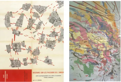
Figure 5 (left) Guy Debord, Discours sur les passions de l'amour, 1957; dissected map of Paris, lithograph on paper, edition size unknown
(Source: Storr 1994, p. 33)
Figure 6 (right) Julie Mehretu, Looking back to a bright new future (detail), 2003; ink and acrylic on canvas, 241 x 302 cm
(Source: Harmon 2004, p. 165)
Key figures of SI included Guy Debord and Constant Nieuwenhuys (known as Constant), who constructed dérives or drifts through the city, and accepted the vagaries of chance. Their philosophy was derived, in part, from Johan Huizinga’s notion of the significance of play in culture and art (Huizinga 1955). Debord, main theorist of the SI group, would deliberately lose himself in Paris, cut up a standard tourist map, then reconfigure it symbolically to undo the rigid social organization of the city. Thus, as Robert Storr explains, the mysteries of Paris would be restored to the streets (Storr 1994, p. 17). Constant brought three‐dimensional form to the theory of dérive; in a series of models designed for New Babylon, homo ludens (man the player) could explore and transform the landscape, with its increasing class division and social injustice, without the obligations of work, as noted by Francesco Careri (2003, p. 110). As well as an inclination to disrupt map structure and allow circumstance to prevail, my practice recognizes the play‐concept as a powerful tool in learning. But play is an undercurrent, not the main game.
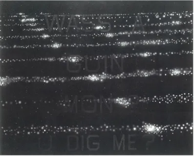
which, as well as providing a system of measurement, become a principal element, as Rudolph Arnheim suggests, in organising Western pictorial space (Arnheim cited in Jacob 2006, p. 121). The gridded dots (city lights, perhaps) of Ed Ruscha’s Where are you going, man? (Fig. 7), provide the metropolitan structure for his friend’s vernacular Gullah dialect – a structure which both hovers and absorbs.
[image:19.595.127.524.198.519.2]
Figure 7 Ed Ruscha, Where are you going, man? Do you dig me? (for Sam Doyle, folk artist), 1985; oil
and enamel on canvas, 152 x 198 cm (Source: Friedman 1994, p. 155)
On the ground, the Cartesian grid is seen as democratising (in social/architectural terms) or, as JB Harley describes, in the imperial context, homogenising all in its path (Harley 1992, p. 282). Regular divisions may disregard terrain or prior occupancy. The plan of Cosa (Fig. 8), a Roman defensive hilltop town founded in 273 BC, grids the topography for strategic
grid are complemented by an irregularly linear park system running on the vertical (Kostov 1991, p. 155). The former colonises, the latter democratises.
[image:20.595.128.501.134.498.2]
Figure 8 Plan of Cosa, Italy, 273 BC
(Source: Kostov 1991, p. 106)
Figure 9 Schematic plan of Chandigarh, India, 1951
(Source: Kostov 1991, p. 155)
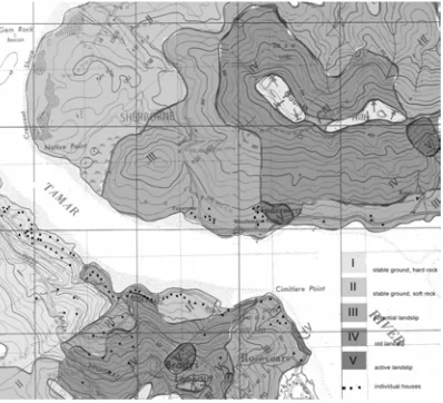
Locally, a plan of subdivision in 1904 (Fig. 10) illustrates the homogenising carve‐up of western Tamar slopes, while the blank slate of the Conversion Plan of this property (Fig. 11), in isolation, indicates nothing but size. It should be understood, however, in the context of topographic harmony and the cacophony of suburban development. Dictated by geology (Fig. 12), parts of the mosaic should probably be left alone.
Figure 10 Orchard sites on River Tamar: subdivision plan of portion of “Strathlyn” Estate, near
Rosevears, the property of Thomas Gunn, Esq., 1904; sale poster, Alfred Harrap & Son, size unknown
[image:21.595.127.331.511.719.2][image:22.595.129.276.85.317.2]
Figure 11 Conversion Plan P125535, 1996
(Source: Land Information System Tasmania n.d.)
Figure 12 West Tamar residential development, 2010; based on Landslide Zone map, 1986, and
Tasmanian Towns Street Atlas, edition 7
(Source: Telfer 1988, p. 43; Tasmanian Towns Street Atlas 2005, p. 79)
[image:22.595.128.327.377.558.2]
2006, pp. 123‐127). As Jacob indicates, the rhumb lines do not measure space or time but they minimise chance and affirm the possibility of travel. Or, as Giuliana Bruno notes, with her interest in cinematography, the lines serve to ‘materialise motion’; as does portolan toponomy (Bruno 2002, p. 182).
[image:23.595.127.296.145.334.2]
Figure 13 East coast of Jave la Grande (Australia) in the ‘Vallard’ atlas, 1547 [south is at the top] (Source: Richardson 2006, p. 38)
Toponomy remains a graphic device of mapping. While portolan charts map their coastlines in textual flourishes (see Fig. 13 above), at its spare extreme, Ed Ruscha’s Sunset/P.C.H. (Fig. 14) might be regarded as toponomically challenged.
Figure 14 Ed Ruscha, Sunset/P.C.H., 1998; acrylic on paper, 35 x 55 cm
[image:23.595.127.485.513.737.2]Paul Carter’s Nearamnew (Fig. 15), in collaboration with Lab architecture studio and others, opened in 2003 as the ground plane design of Federation Square, Melbourne, with text incised into ‘marble cake’ Kimberley sandstone cobbles; nine regional forms made from letters that name the site, each with a local vision of Federation – in unique Federation font. Carter describes the use of text in this instance as being about ‘walking about’, taking writing back to its calligraphic grooving roots of making boundaries and marking the ground (Carter 2005, p. 3). Federation Square functions well as a gathering and transition space. Within that role of contemporary forum, the incised text of Nearamnew acts sculpturally and in play, although deliberately ambiguous in its readings (the overall whorl pattern is discerned more easily than the words).
Figure 15 Paul Carter, Nearamnew (details), 2003; Federation Square, Melbourne, Kimberley
sandstone in unique Federation font, 7500 m2 (Source: Carter 2005, p. 52)
Jacob distinguishes between the written map, where text infiltrates topography, and archipelago text, in which fragments appear at locations they describe, allowing text as map, and map as text (Jacob 2006, pp. 190‐191). In Conversion converted (Fig. 16) I have used survey text (of significance only to those in the Lands office) as a graphic device to delineate and locate the property.
Figure 16 Conversion converted, 2010; digital drawing based on Conversion Plan P125535, 1996
Scale is the zoom lens of cartography, miniaturizing and magnifying to provide context and calculable space. A scale bar (see Fig. 9), unlike rhumb lines, sets ratios accurately to estimate distance and increasingly to minimise chance. Overlapping or exaggerated scales can produce slippery distortions and take you to unexpected places.
In social research triangulation is often used as a way of enhancing confidence in results when gathering and interpreting data. Derived from surveying, the term refers to the use of a series of triangles to map out an area. Alan Bryman notes that, as a multi‐method
approach, it allows researchers to collect both quantitative and qualitative data from primary and secondary sources (Bryman n.d.). It has been suggested by Elaine Martin and Judith Booth that an art‐based thesis should explore an issue from two or more ways of knowing; for instance, by uniting aesthetics and science through an iterative process where one domain inspires the other (Martin & Booth 2006, pp. v‐x). In this research triangulation can be seen, not so much to validate findings, but to cross‐reference, illuminate and intensify layers of meaning.
soulèvement is the geological context (to lift upwards, the space between ‘form’ and the earth); triangulaire is a series of triangulated stone ‘viewing platforms’ at the edge of Alum Cliffs Tulumpanga, the journey to the cliffs following aboriginal ochre routes and celebratory places; and point de vue triangulates the three major physical references of Quamby Bluff (1226 metres), and The Gog Range – Alum Cliffs Tulumpanga Gorge and Western Bluff (1420 metres) as seen from the site of the sculpture (Jones 2001). In 2010 the sightlines had been obscured by tree growth but the landmarks clearly remained. All materials are locally sourced, with timber levitating on stone.
Figure 17 David Jones, Soulèvement – triangulaire, point de vue (2), 2003; Great Western Tiers
Sculpture Trail, eucalyptus ‘arms’ and granite ‘floaters’, approx. diameter 20 m (Source: Jones 2003)
James Turrell triangulated his site plan of Roden Crater (Fig. 18), surveying an extinct volcano in Arizona to locate a series of sky‐viewing chambers as observatories for solar and lunar effects. As John Beardsley suggests, Turrell’s work mediates physical, psychological and temporal dimensions of our seeing (Beardsley 1994, p. 175).
Figure 18 James Turrell, Roden Crater, 1992; site plan with survey net and alignments, mylar,
beeswax, emulsion, ink, liquitex, wax pastel, 106 x 228 cm (Source: Friedman 1994, p. 174)
Grid‐planning, while considered not as accurate as triangulation, is often used in
archaeological practice, as described by Sara Champion, to measure an area, usually with a metre‐square frame strung at ten‐centimetre intervals, to translate information on the ground at scale onto paper (Champion 1980, p. 58). As such, it is a relatively fast and reliable means of mapping.
There have been many attempts over the centuries to develop map projections to decipher a globular world in two dimensions, without losing proportional integrity – with varying degrees of success. Rhumb lines of the cylindrical Mercator projection, from the mid‐ sixteenth century, allowed for constant linear scale, a useful aid to navigation, but
distortions occurred as distance increased from the equator. In the climate of World War II, and driven by the reality of an air travel world, R. Buckminster Fuller largely eliminated proportional bias with his Dymaxion Projection (Fig. 19), as identified by Joachim Krausse and Claude Lichtenstein, based on an icosahedron construction (Krausse & Lichtenstein 1999, p. 250); Fuller’s work, in turn, inspired Jasper Johns’s Ocean (Fig. 20) for Merce Cunningham’s dance of the same name (the nineteen‐triangle format interprets the nineteen‐part structure of the dance) (Johns 1996).
Figure 19 (left) Buckminster Fuller working on his Dymaxion Projection, 1943; dimensions unknown
(Source: Krausse & Lichtenstein 1999, p. 251)
Figure 20 (right) Jasper Johns, Ocean, 1996; lithograph, working proof with ink, 58 x 78 cm (Source: Johns 1996)
Cartography, for text‐based societies, traditionally has required permanence, a physical support, typically from vellum to paper. Tracing cartography’s etymology, John Stilgoe muses on chartreuse:
… a splendid word to crash into during a marshland voyage, a word linked somehow, perhaps by a gutter, to chart. The root word is old, echoing across an abyss of time from the English card to the Latin charta meaning paper, itself derived from the Greek chartes, somehow meaning ‘a leaf of paper’... Books still have leaves, but no longer does card designate a chart (Stilgoe 1994, p. 37).
From verb to noun, with or without chartreuse, the making of charts has joined graphein, to draw or record and become part of the graphic arts. In contemporary practice, graphics are still involved but mapping is not always cartography, and paper is not always the medium.
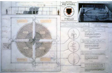
Since the 1960s artists have experimented with environmental processes and systems and mapped the outcomes as artworks. Artworks also became synonymous with earthworks, which were often subsumed in a natural cycle of weathering – for example, Robert
Figure 21 Mel Chin, Revival Field, 1990; schematic drawing, graphite, ink, photocopied images on rag board, plot approx. 18 x 18 x 2.7 m
(Source: Chin 1990)
Topographic (of a particular place) and chorographic (regional) cartographies should be distinguished from the broader realm of absorptive mapping, as proposed by Edward Casey (Casey 2005, p. 150). Absorptive mapping captures the lived experience of a place and as such is primal, perceptual, or elemental in its response. My own work borrows from traditional cartographic practice but drifts more often into phenomenological readings of landscape. The ephemeral and the temporal are also involved as I foray into mapping.
Corner (1999) advocates mapping as perhaps the most formative and creative act of any design process. As such, the act of mapping takes precedence over the finished artifact. He sees mapping as doubly operative – digging, finding, and exposing on the one hand; relating, connecting and structuring on the other – setting the conditions for discovery and
exploration, as it always has done. New and speculative techniques of mapping, he suggests, might generate creativity and offer surprising solutions (Corner 1999, pp. 216‐217, 225).
To expose that elusive ‘authenticity’, Martin Heidegger may be of assistance as he finds in the German bauen, to build, the etymological roots of dwelling. Like the Latin colere, the word has connotations with protecting, preserving and cultivating the soil, rather than in building edifices or merely existing alongside other activities (Heidegger 1971, pp. 144‐145). Thus, Casey’s absorptive approach to mapping and Heidegger’s notion of bauen may offer a way to locate the place of ‘essential’ or ‘authentic’ dwelling. By combining the base
elements of cartography with the perceptual and the actual of landscape, I seek an
___________________________________________________________________________________
CHAPTER THREE
triangulating the practices
(theirs with mine)
Every landscape is an accumulation … an enormously rich store of data about the peoples and societies which have created it, but such data must be placed in its appropriate historic context if it is to be interpreted correctly (Meinig 1979, p. 44).
As Donald Meinig illustrated in his ‘Ten versions of the same scene’ (1979), acknowledging the history of a place is just one way to interpret a landscape – consider also its systems, habitats, problems, ideology or aesthetics, for instance, and the fact that landscape is a great exhibit of consequences (Meinig 1979, pp. 33‐48). The consequences of occupation and subsequent neglect are evident in this former orchard, now my responsibility, but to see the whole requires passes from several angles. To that end, the review of artistic precedent was helpful in determining my viewpoints.
Aesthetic sensibility, working premise and underlying philosophy narrowed the field of influence from an initially broad survey of artists to the few who are studied here – Janet Laurence, Fujiko Nakaya, Julie Mehretu, Anne Wilson and Maya Lin. It was my interest in landscape architecture that led me to their work, particularly those who exhibit a direct response to the landscape and/or collaborate with design practitioners on site‐specific projects.
While Laurence and Nakaya make only oblique reference to mapping, their works speak, nevertheless, through fundamental issues of cartography (measurement, enquiry, examination, exploration) of ecological and/or cultural concerns. Laurence embarks on a forensic examination in her many‐layered, multi‐focus landscapes, while Nakaya explores the single, powerful idea of fog. The mercurial nature of the matter resists linear limitations to find new, albeit blurred, edges of topographic knowledge. Lin and Wilson make more overt responses to map‐making, in and of the built environment, physically staking out an imagined landscape. Mehretu, mixing lines of precision with textural flourishes, extrudes and contracts architectural references, mapping parts of her past over speculative, labile projections.
arts. Within the spectrum of these disciplines Laurence ranges across media, but I refer here particularly to her use of glass and acrylic, both significant elements in her work of recent years. Her choice of these materials allows transparency to the subject, while layering of photographic images is made more contemplative by introducing substances like shellac and paint, veiling her work and adding complexity to meaning. Laurence says she does not employ photographs singly, but ‘unsettles’ them to find the fluid, unstill moment, as reported by Rebecca Whitton (2009, pp. 26‐30). Laurence’s Crimes against the landscape series (Fig. 22) is typically alchemical both in process and in presence, bringing the laboratory into art in a curiously recognizable experiment.
Figure 22 Janet Laurence, Forensic sublime: crimes against the landscape: Styx Forest, 2008; mirror,
oil glaze and duraclear on Shinkolite acrylic, 100 x 455 cm (Source: Whitton 2009, pp. 28‐29)
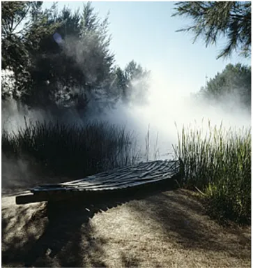
Fujiko Nakaya has deployed fog in her many sculptures throughout the world, notably in Canberra and Bilbao. The ethereal qualities of the National Gallery of Australia installation are strikingly evocative of a Canberra winter, sometimes obscuring Robert Stackhouse’s bronze On the beach again. Originally installed in Sydney’s Domain as part of the 1976 Biennale, Fog sculpture #94768: earth talk was relocated to its current home as Fog sculpture #94925: Fog wake in a desert: an ecosphere (Fig. 23), where a fine mist
Figure 23 Fujiko Nakaya, Fog sculpture #94925 ‘Fog wake in a desert: an ecosphere’, 1976; water
vapour, dimensions variable
(Source: National Gallery of Australia n.d.)
Figure 24 (left) Julie Mehretu, Inkcity (small 3), 1996; ink on paper, 40 x 35 cm
(Source: Zegher, Golden & Mehretu 2007, p. 39)
Figure 25 (right) Julie Mehretu, Untitled, 2000; ink, coloured pencil, cut paper on Mylar, 45 x 61 cm
(Source: Zegher, Golden & Mehretu 2007, p. 70)
Figure 26 (left) Anne Wilson, Portable city (detail), 2008; textiles, wire filament, 47 mobile vitrines, variable dimensions, average 50 x 76 x 83 cm
(Source: Wilson 2008)
Figure 27 (right) Anne Wilson, Topologies (3‐5.02), 2002‐ongoing (detail of installation at the Whitney
Biennial, New York, 2002); lace, thread, cloth, pins, painted wood support, 78 x 188 x 548 cm (Source: Wilson 2002)
By contrast, Maya Lin’s ‘topologies’ are a series of studio‐based, small‐scale non‐site specific sculptures which explore fundamental issues of geomorphology or physical phenomena – ice floe patterns, river‐worn rocks, topographic contours, wave formation – to underpin her large‐scale site‐specific projects (Lin 2000, p. 8.02). Many of these works have their genesis in plasticine, or, in the case of Wave field (Fig. 28), in sand and clay – the plasticity of modelling materials allowing for subtle changes through iterations that may later be realized in built landscape form. Lin describes having to distort in situ the grid pattern of Wave field to retain the fluidity of her earlier models, lost when scaling‐up (Lin 2000, p. 6:21); completing the modelling by hand, each wave becomes unique. Lin places significant emphasis on context and tradition when researching ideas for her commissions; her
interventions, she says, are organic, inclusive and integral to the site (Lin 2000, p. 6:31). Her Wire landscape (Fig. 29) and Untitled (plaster relief landscapes) (Fig. 30) are both studies for larger works and exhibited in their own right.
Working as an artist and architect, Lin separates her dual practices but allows that they inform each other, partly through a Japanese aesthetic, deceptive in its simplicity, manifest in both her sculptural works and architecture. She acknowledges Robert Smithson and others as inspiration but also uses computer generated models and scientific data for reference.
Figure 28 Maya Lin, Wave field, 1993‐95, University of Michigan; soil, sand, grass, approx. 30.5 m2
(Source: Lin et al. 2006, p. 88)
Figure 29 (left) Maya Lin, Wire landscape, 2006; steel wire, 218 x 509 x 20 cm
(Source: Lin et al. 2006, p. 53)
Figure 30 (right) Maya Lin, Untitled (plaster relief landscapes), 2005; plaster on drywall, approx. 60 x 60 x 2cm
(Source: Lin et al. 2006, p. 56)
Is theirs a hermeneutic response? Not altogether. Notions of ‘contextual fore‐knowledge’ are more obvious in the works of Lin and Laurence, whereas Nakaya’s fog sculptures are purely phenomenological. Where Wilson’s topologies grow in mycelial fashion from a substrate of conjecture, Lin will often coax hers out of scientific residua to ground them firmly in fact. Mehretu allows architectural ideas to mingle freely with gestural notations in her visually tactile charts. Common to each is their interpretation of contemporary society and the ability to communicate meaning through material, context or form where
While these artists were of primary influence during my research, I was also interested in the work of others: John Wolseley for his mappings which present information overlaid at different scales, often drawing links across continents to find common ecological ancestries, as illustrated broadly by Sasha Grishin (2006); Jennifer Turpin and Michaelie Crawford, collaborating on many site‐specific works which respond in a direct way to the energies of wind and water, as noted by Margaret Baguley (2006); Christiane Löhr’s delicate sculptures made from plant material (Löhr 2006); Cornelia Parker who, in an interview with Ina Cole, explains her reconfiguration of materials and objects that have symbolic meaning in society (melted wedding rings, bullets, silver‐plate, brass instruments), to create works that are often in flux – leaning, hovering, vulnerable, in transit – reflecting her/our increasingly fragile relationship with the planet (Cole 2009, pp. 37‐43); Christl Berg’s photographs and scans of minutiae thrown up by the sea, as illustrated by Jonathon Holmes in Berg’s
exhibition catalogue (Holmes 2010); and Mark Stoner’s installations, typically his 1995 ferro‐ cement Cone, where he takes a rubbing from a constructed stone cone to translate surface texture to paper (Stoner 1995). Echoing the geometry of his three‐dimensional structure onto the wall, in essence, he is making a map projection.
Each of those artists invites the viewer to reflect on social and environmental issues, interconnectivity, or adaptation to a changing world. There were resonances in their work with aspects of my own but less so than with the five more broadly examined. My own research takes inspiration from, and builds on, these varied arts practices as I negotiate the ruderal landscape of home.
___________________________________________________________________________________
CHAPTER FOUR
grid unlocked
Let the ground rise up to resist us, let it prove porous, spongy, rough, irregular – let it assert its native title, its right to maintain its traditional surfaces – and instantly our engineering instinct is to wipe it out; to lay our foundations on rationally‐apprehensible ground (Carter 1996, p. 2).
While accepting the irregularities of my recently adopted ground, I felt the need to understand their sources before wiping some of them out. What were the influences, the qualities of survival, the agents of change in this microcosm of northern Tasmanian
subfarmland? How might these traits contribute to a grounded landscape design? As well as from the site itself, I sought inspiration across sciences and arts, to evolve under a canopy of time.
Like Laurence, my practice seeks to accommodate the threshold of environmental planning and art, in some instances through the use of glass, a material whose qualities help to express the fragility of ecological balance. The source of glass panels in my work is a
dilapidated glasshouse, collapsing under the weight of blackberries. The building indicates a former productive life at commercial scale, but because of its current demise, and unlikely to resume full hothouse duties, there was potential for reuse of the parts. Intact, cracked or stacked, the panels are inherently layered with meaning; by manipulating images and etching geometry or text into the passive accretions of rust and encrusted lichens I can explore correspondence of the built bumping up against chance. The reflected, ambiguous inscriptions on glass invite introspection and a conduit to liminal space.
studies to reflect on the fugitive nature of local atmospheric phenomena and our contribution to their making.
From the transparency of glass and the ephemerality of fog I came to the solidity of wire and wood, abundant and abandoned on the property. I was prompted, with these materials, to explore the impact of neglect as a passive force for design. Even in their decayed or tangled state, the walling and fencing materials symbolise the marking of territory,
providing protection and ultimately exerting control – in relinquishing that control they take on new unintended meaning.
The palette of materials increased substantially as blackberries and the hayloft were cleared, slowly revealing the artifactual history whose texture and context began to suggest form. Those materials became integral to the project as a means of expressing the site’s fragilities, resilience and connectedness, qualities that became apparent during the research. In the process of mapping, subtle shifts of perspective gave broader views of the project as the property developed into studio, canvas, palette, toolbox and potential gallery. It provided the inspiration and the raw material, from the emergence of concepts to the concreteness of work.
In geological terms, Graham Fish and Murray Yaxley note that land is sculpted by running water in a normal cycle of erosion (Fish & Yaxley 1966, p. 87). Watching such erosion on partly denuded soils, on a valley hillside and with a close relationship to the river, it became apparent that water was a dominant factor in this project – in weed distribution, in
irrigation, drainage and effluent treatment, and in accommodating the distribution pipeline. Reactive clay soils were a measure of change, simultaneously shifting seedbed locations, once‐solid structural foundations and my attitude to working the land.
Considering geology and river formation, I made a plaster cast of a crack in the dry summer soil (Fig. 31), and could not dig it out until July rains softened the clay; when compared with a map of the Tamar River (Fig. 32) the similarities seemed only a matter of scale.
Figure 31 Cracked, 2009; plaster cast of crack in soil,
poured February, excavated June
Figure 32 Map of Tamar River, West Arm
(Source: Branagan 1994, p. 111)
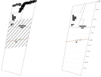
From July to September the stormwater ditch was mapped as a deepening, widening wire‐ frame gutter (Fig. 34), adjusting its line and its length to the forces of overland flow. Dolerite rocks and discrete river pebble horizons, dictate, and are exposed by, the coursing. Alert to geology and the habits of water, a pegged‐out profile of the valley (Fig. 35) might help when siting a building, to anticipate flow‐on effects.
[image:41.595.126.410.194.412.2]
Figure 34 Heavy at times, contracting to the east, 2011 (detail);
recycled chicken wire, fire‐cracked glass shards, approx. 50 x 300 x 60 cm
[image:41.595.125.409.480.751.2]
The big picture of the new home initially was considerably daunting so I began with close readings, tackling manageable portions with few resources – getting a feel for the place, literally feeling my way around. Through walking, rubbing, raking, scraping, digging, transposing, squashing and moulding I began making my own marks, recording the purposeful actions of others and observing the legacy of inertia and neglect (Figs 36‐39).
Figure 36 Rubbing and staining, 2009; (left to right) a half‐buried bolt cutter; tyre rims and treads; blackberries pressed into lace, then lace into paper, then paper peeled back
Figure 37 Impressions, 2009; (left to right) possum on quince; bird on quince; bird on fig; grub in branch
Figure 38 Inertia, 2009; (left) dust rings on linoleum from pantry shelves where Fowlers jars of
Figure 39 Repetition, 2009; (left) wallaby tracks in grass; (right) blackberry canes against glass
I considered cultural connections, both temporal and spatial, within and beyond the site. There was historical evidence of a thriving river trade connecting the apple industry with export markets via Blackwall, and of innovative timber construction (Figs 40, 41). The river is now commercially and recreationally quiet; brick now dominates timber.
[image:43.595.129.514.471.690.2]
Figure 40 (left) Connecting I; stencilled apple crates from the barn, circa 1950
Figure 41 (right) Connecting II; ‘building a “corduroy track” over swampy ground, 1932’
And as subdivision of farms altered the profile of the area, the roles of fencing and naming changed. Once genuflecting to the Motherland (Oban, Grasmere, The Chelmer), naming of property (Fig. 42) now reflects landscape features and occupancy (Highview, Pope’s Nest, Rice Grass College). Front fences, where they exist, are dedicated to screening rather than withholding valuable livestock; plants often take on the task.
[image:44.595.193.496.187.484.2]
Figure 42 Naming, 2011; digital text and line drawing, 100 x 100 cm
These materials, connections and experiences were rich pickings for mappings, as the following works attempt to transcribe. A bewildering array of tasks to render the house habitable meant the most immediate concerns were approached first.
It started with rats – small, but not an insignificant aspect of rural life. While rats are natural tree dwellers or burrowers, some prefer the warmth of a farmhouse wall cavity where food and accommodation are cheap. Their ‘runs’ can be mapped from the house to the
outbuildings; both are favoured nest sites. Accumulated nesting materials provide
The black rat (Rattus rattus) is an introduced species and key ecosystem changer; it has proved highly adaptive to human habitation. During the demolition phase of house
renovation a decomposed rat carcass was found under the floor, and rat nest material was gathered from wall cavities. These nests and skeletal remains became the basis for
composite images reproduced onto glass – Rattus rattus (Fig. 43) and manipulated photograms – Rattus nestus (Fig. 44).
[image:45.595.127.537.216.440.2]
Figure 43 Rattus rattus, 2010; digital images on recycled glasshouse glass, each panel 51 x 46 cm, overall assembled dimensions variable
Figure 44 Rattus nestus, 2010; photograms of fragments of rat nest material reproduced on
[image:45.595.131.538.511.721.2]While the presence of rats was immediately evident, the broader measure of human impact in this environment required exploration, to encompass essential service infrastructure and its limitations. A significant presence on the property are Transend high voltage overhead transmission lines that crackle and fizz in moisture‐laden air, and Ben Lomond Water mains pipeline, buried; both within the same easement, both requiring special consideration when planning land use – enforced restrictions, allowable activities, joint responsibilities. Imposed restrictions include kite‐flying, model aircraft, flammables and explosives stores, swimming pools, galvanized sheds and trees over three metres. Animals may roam, small structures may be built; mobility and flexibility are preferred. Under such conditions, and left unattended, ruderality thrives. Force field (Fig. 45) and Undercurrent (Figs 46 and 47) together map the extent of the easement and implications for land management, expressed through geometry, image and text. Wayfinding is attempted in the process.
[image:46.595.127.408.336.710.2]
Figure 45 Force field, 2011; recycled timber lathes, whitewashed, each frame 90 x 90 x 90 cm, overall


![Figure
13
East
coast
of
Jave
la
Grande
(Australia)
in
the
‘Vallard’
atlas,
1547
[south
is
at
the
top]
(Source:
Richardson
2006,
p.
38)](https://thumb-us.123doks.com/thumbv2/123dok_us/8427670.331194/23.595.127.485.513.737/figure-east-jave-grande-australia-vallard-source-richardson.webp)