Abstract: Good roads play important role in positive growth of our civilization. They revolutionize and increase the life style of us and directly affect all our activities. Having record of up-to-date roads helps in taking quick decisions and pre-planning for various occasions like road trip or life critical situations like disasters. . It also helps in making maps for city planning and keeping track of expansion of city. Here, we have adopted morphological operations based techniques. All the images are resized to have same dimensions as they are from different sources. Comparison with ground truth images (manually extracted) is done to examine the performance of the algorithm. As this method is solely based on intensity of road pixels, the effect of different road structures and lane markings is absent. The algorithm has achieved 89% F1-score and 94% accuracy. Further improvement is required in algorithm to detect roads where the intensity of non-road parts (urban area, mowed agricultural land and other similar intensity structures) is similar to road pixels.
Index Terms: Satellite images, image processing, road detection, Road extraction, morphological operations, feature extraction, edge detection
I. INTRODUCTION
With the increase in the population density the need for good transportation system and roads is increasing. Thus, giving rise to increasing city area too. The need for updated maps comes when we have to do planning of the city or when finding shortest route to some place. It also proves helpful during rescue operations. Earlier it was a manual process with lot of human intervention and cost. Manually checking and drawing lines of roads on the map was common sight. With the launch of high-resolution commercial imaging satellites like IKONOS (1999) and Quick Bird (2001), we can use these aerial images for faster processing. For large database the use of neural networks (NN) proves beneficial. Here, we have concentrated on the effect of morphological operations and other image processing techniques to achieve the result.
[1] Used method based on threshold detection. Using Unmanned Aerial Vehicle (UAV) images and overlaying road vector data (prior data) the conditions of road were found. Using ArcGIS and eCognition, the image was buffered and segmentation was done. [2] Used edge detection (using Canny operator), Full Lambda Schedule for merging adjacent segments, Support Vector Machine (SVM) for classification, and morphological operators to improve quality of detected road. Various satellite images from Worldview, QuickBird and UltraCam were used for analysis. Overall accuracy (OA) achieved is more than 85%. Improvement required in detecting complex roads more accurately. [3] Took data from three different places for study, training and test area. From Optech Titan sensor multispectral Airborne Laser Scanning (ALS) data were
acquired. For comparison open data from National Land Survey (NLS) used. Matlab’s fitensemble with bragging used for classification. 80.5% points representing roads were classified correctly. [4] Have used IKONOS panchromatic image and QuickBird image for experiment. Directional Texture Signature (DTS) and Geary’s C are used for segmentation of road using radiometric features and to obtain homogeneous map. Geary’s C measure spatial autocorrelation (correlation is multi-dimensional and bi-directional) providing us binary image. Using area-based filtering and length-width-ratio-based filtering non-road information is removed. It gave 85.94% correctness. Further improvement can be made using road shape features for threshold selection. [5] Based on object-based methods & uses spatial texture features (extracted by local Moran’s I). Hypothesis formed using features (brightness, standard deviation, rectangularity, aspect ratio, and area) and verification done using morphology operations. Achieving 90% accuracy. [6] Automatic extraction of road centerlines was achieved by using automatic thresholding and morphological operations. [7] Presented multi-stage approach based on integration of structural, spectral, textual and contextual information. Tensor voting used to fill missing parts. Have used same road dataset made publicly available by [17]. Author is able to achieve 93.4% Correctness. [8] Devised automated road extraction method based on vectorization approach.
II. METHODOLOGY
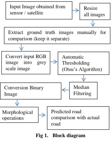
Initial efforts are required to select appropriate dataset / resources for work. Various free to download aerial images and Remote Sensing / Satellite images along with ground truth were collected for processing. They are converted into grey scale image to increase speed of algorithm. Othsu’s thresholding method is used to get the automatic theresholding value for the images. It helps in converting the image into binary image. Median filters are used to reduce noise. Finally morphological operations are employed to obtain final road image. All the image planes are resized to 600x800 to have correct comparison report performance metrics.
Road Detection & Extraction for Autonomous
vehicles Using Satellite Images
International Journal of Innovative Technology and Exploring Engineering (IJITEE) ISSN: 2278-3075, Volume-8 Issue-10, August 2019
Fig 1. Block diagram Algorithm:
1. Select RGB Satellite Image and ground truth using uigetfile().
2. Default Image size chosen to be 600 rows X 800 columns for all images. Using imresize () MATLAB function, all images are resized.
3. The ground truth image (extracted manually or already available online for research) is converted into binary image by keeping only pixel values more than 200 (decided after checking histogram of the image) and rescaling them to 1. Thus, removing noise in true ground image.
4. Input image is converted into Grey scale and morphological operations and filters applied as per block diagram. Thus, predicted road structure is obtained. Sobel filter used for edge detection to overlay predicted road on original road image using vision.AlphaBlender and step().
5. Finally, the performance parameters measured with respect to predicted road and actual ground truth. The parameters are obtained by comparing both the images pixel values and keeping count of all the True Positive, True Negative, False Positive & False Negative values.
III. EXPERIMENTS
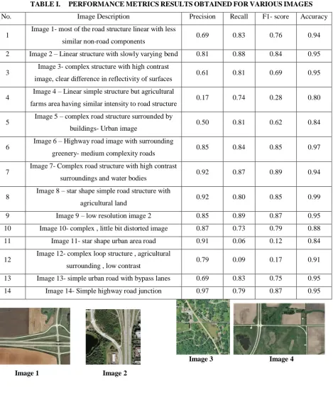
Various performance metrics are precision, recall, F1-score and accuracy. Precision gives indication of how many pixels are correctly identified from total pixels. Recall (Sensitivity) describes as how many are correctly identified pixels out of labeled pixels. F1-score is weighted average of precision and recall. It is considered better than accuracy as it can handle un-even class distribution of data too. Accuracy is good for symmetric dataset.
(2)
(3)
(4)
Where,
TP = True Positive, pixel predicted as part of segment (correct), equivalent with hit,
TN = True Negative, pixel predicted as not part of segment and from reference it’s confirmed its not part of segment, equivalent with correct rejection,
FP = False Positive, Predicted pixel as part of segment but from reference it’s not part of segment. Equivalent with false alarm, Type I error
FN = False Negative, Predicted pixel as not part of segment but from reference its part of segment. Equivalent with miss, Type II error.
We have used MATLAB R2017a software on Intel® Core™2 Duo CPU @2.40GHz, 4.00 GB RAM, 64 bit operating system and Windows 7 Ultimate edition. The graphical user interface (GUI) developed has following layout.
Fig 2. Graphical User interface (GUI) design created using GUIDE
The method is fully automated and can work with large database with little modification. Following image shows test result for two images.
Fig 3. Road extraction result for Image 1, Accuracy 94%
Input Image obtained from
sensor / satellite Resize all images
Automatic Thresholding (Otsu’s Algorithm)
Conversion Binary Image
Median Filtering
Morphological operations
Extract ground truth images manually for comparison (keep it separate)
Convert input RGB image into grey scale image
Predicted road
[image:2.595.61.277.48.322.2] [image:2.595.306.548.362.490.2] [image:2.595.304.549.580.696.2]Fig 4. Road extraction result for Image 6, Accuracy=97%
TABLE I. PERFORMANCE METRICS RESULTS OBTAINED FOR VARIOUS IMAGES
Image 1 Image 2
Image 3 Image 4
S. No. Image Description Precision Recall F1- score Accuracy
1 Image 1- most of the road structure linear with less
similar non-road components 0.69 0.83 0.76 0.94
2 Image 2 – Linear structure with slowly varying bend 0.81 0.88 0.84 0.95
3 Image 3- complex structure with high contrast
image, clear difference in reflectivity of surfaces 0.61 0.81 0.69 0.95
4 Image 4 – Linear simple structure but agricultural
farms area having similar intensity to road structure 0.17 0.74 0.28 0.80
5 Image 5 – complex road structure surrounded by
buildings- Urban image 0.50 0.81 0.62 0.84
6 Image 6 – Highway road image with surrounding
greenery- medium complexity roads 0.85 0.84 0.85 0.97
7 Image 7- Complex road structure with high contrast
surroundings and water bodies 0.92 0.87 0.89 0.94
8 Image 8 – star shape simple road structure with
agricultural land 0.92 0.80 0.85 0.99
9 Image 9 – low resolution image 2 0.85 0.89 0.87 0.95
10 Image 10- complex , little bit distorted image 0.87 0.73 0.79 0.88
11 Image 11- star shape urban area road 0.91 0.06 0.12 0.84
12 Image 12- complex loop structure , agricultural
surrounding , low contrast 0.79 0.09 0.17 0.91
13 Image 13- simple urban road with bypass lanes 0.69 0.83 0.75 0.95
[image:3.595.56.526.166.719.2]International Journal of Innovative Technology and Exploring Engineering (IJITEE) ISSN: 2278-3075, Volume-8 Issue-10, August 2019
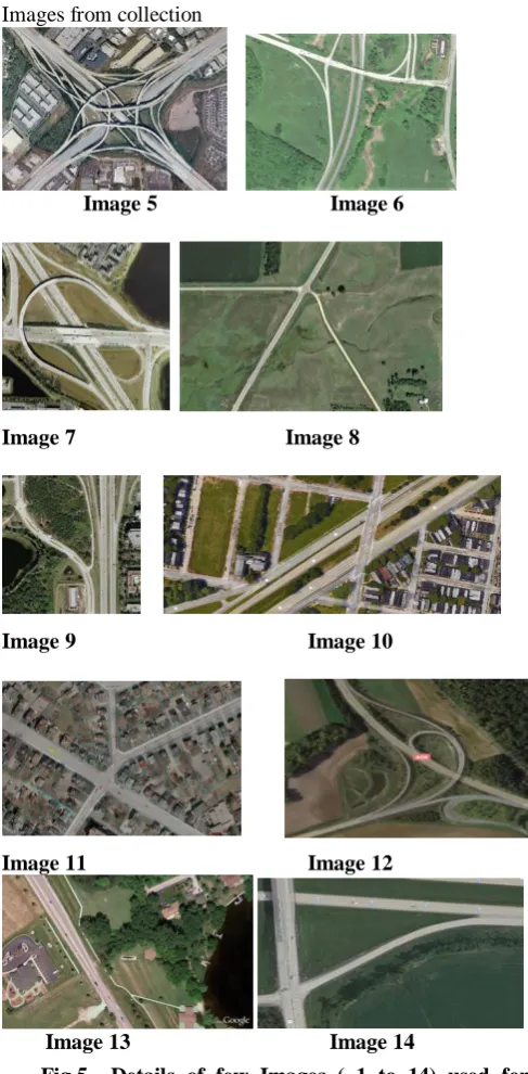
Images from collection
Image 5 Image 6
Image 7 Image 8
Image 9 Image 10
Image 11 Image 12
Image 13 Image 14
Fig 5. Details of few Images ( 1 to 14) used for research from Google Images and Github.
IV. CONCLUSION
The road detection and extraction algorithm was able to achieve more than 90 % performance score for various images with different dimensions and resolution. The decrease in score can be attributed to variation in sources of image, image quality and having man-made & natural structures with similar intensity values like road structure in the image. Future work involves taking into consideration road parts not visible by tree and other structures and also involving a methodology to reduce similar intensity non-road pixels from getting selected as true road pixels. The methodology can be extended for large database using neural networks and updating maps simultaneously. Due to wide area of scope this research is interesting and can be extended
ACKNOWLEDGMENT
The authors gratefully acknowledge support received from all the people from JSPM’s ICOER college (Wagholi, Pune), AIT college (Dighi, Pune) and TechSmart Systems Company (Pune & Mumbai) for their continued support and guidance.
REFERENCES
1. Zihan Chen, Aixia Dou, “Road damage extraction from post-earthquake UAV images assisted by vector data”, The international archives of the photogrammetry, remote sensing and spatial information sciences, Volume XLII, 2018
2. Hamid Reza Riahi Bakhtiari, Abolfazl Abdollahi, Hani Rezaeian, “Semi automatic road extraction from digital images”,Egypt J. Remote Sensing Space Sci. , 2017
3. Kirsi Karila, Leena Matikainen, Eetu Puttonen, and Juha Hyyppa, “Feasibility of multispectral airborne laser scanning data for road mapping”, IEEE Geoscience and remote sensing letters, Vol 14, No 3, March 2017
4. Ke Sun and Junping Zhang, “Road extraction from high resolution remote sensing images based on multi-features and multi-stages”, Journal of information hiding and multimedia signal processing, Vol 8, number 1, January 2017
5. Jianhua Wang, Qiming Qin, Zhongling Gao, Jianghua Zhao and Xin Ye, “A new approach to urban road extraction using high-resolution aerial image”, International journal of Geo-Information, 2016 6. Abdur Raziq, Aigong Xu and Yu Li, “Automatic extraction of urban
road centerlines from high-resolution satellite imagery using automatic thresholding and morphological operation method”, Journal of geographic information system, 8, 517-525, 2016
7. Mehdi Maboudi, Jalal Amini, Michael Hahn and Mehdi Saati, “Road network extraction from VHR satellite images using context aware object feature integration and tensor voting”,Remote sensing, 8,637,2016
8. Jose Hormese, Dr. C. Saravanan, “Automated road extraction from high resolution satellite images”, Procedia Technology 24, 1460-1467, ICETEST, 2015
9. Teng Xinpeng, Song Shunlin and Zhan Yongzhao, “A novel road extraction algorithm for high resolution remote sensing images”, Appl. Math. Inf. Sci. 8, No.3, 1435-1443 , 2014
10. K. Madhan Kumar and R. Kanthavel, “An efficient road tracking from aerial images by means of filter methods”, JATIT, Vol 62, No.2, April 2014
11. Poonam Uttam Shelke, Dr. Parul Arora, “Semi-automatic road detection for autonomous vehicles”, e-PGPEX-2019, SPPU, Pune, submitted for publication.
12. Poonam Utttam Shelke, Dr. Parul S. Arora, “Survey of various road detection and extraction techniques for autonomous vehicles”, IJRAR, Vol6,March2019
AUTHORS PROFILE
Shelke Poonam Uttam, ME E&TC (Signal Processing) (2017-2019), JSPM’s Imperial College of Engineering & Research (ICOER) College, SPPU, Pune. BE (E&TC) 2008, Army Institute of Technology (AIT), Pune. She has 6+ years of technical training and on-site water treatment projects (Operation, maintenance & execution) experience as Engineer. She has served at Delhi, Mumbai and Bangalore – Indian locations for reputed firms. Research area: Image processing and autonomous navigation. Email id: [email protected]
[image:4.595.46.290.61.557.2]