THESES SIS/LIBRARY TELEPHONE: +61 2 6125 4631 R.G. MENZIES LIBRARY BUILDING NO:2 FACSIMILE: +61 2 6125 4063
THE AUSTRALIAN NATIONAL UNIVERSITY EMAIL: [email protected] CANBERRA ACT 0200 AUSTRALIA
USE OF THESES
This copy is supplied for purposes
of private study and research only.
Passages from the thesis may not be
copied or closely paraphrased without the
DISEASE, SANITATION AND THE 'LOWER ORDERS':
PERCEPTION
AND REALITY IN SYDNEY, 1875-1881
by
ALAN
JAMESCHRISTIAN l"AYNE
VOLUME
IA thesis submitted in partial fulfilment of the requirements of the degree of Doctor of Philosophy at the Australian 'lational Universit:y
i i
This thesis is my own work
Abbreviations
Acknowledge~ents
Synoptic Introduction
CHAPTER ONE
CHAPTER TWO
CHAPTER THREE
CHAPTER FOUR
CHAPTER FIVE
Introduction CHAPTER SIX
CHAPTER SEVE1'
CHAPTER EIGHT
CHAPTER NINE
CHAPTER TEN
CHAPTER ELEVEN
CHAPTER TWELVE
CHAPTER THIRTEEN
Introduction CHAPTER FOURTEEt:
CHAPTER FIFTEEN
CHAPTER SIXTEEN
Conclusion
CONTENTS
VOLUME ONE
PART 1
The Urban Environment City Health and Disease
PART II
Good Rule and Government
City Health Officers in Sydney Preventive Medicine:
to. • • this du ty0
PART III
11your powers are unequal
Charting the City slums: "hotbeds of vice, hotbeds of fever, and hotbeds of death" The Region of Depravity and Moral Death Ye Have The Poor With You Always
PART IV
Homes for Working men Common Lodging Houses Colonial Peabodies A House in the Suburbs
Cleansing the Augean Stable: Slum Clearance, 1857-81
PART V
Smallpox, 1881
PART VI
A i;ew Sydney: Slum Clearance, 1881-90 Moore Street, 1890
i i i
iv
VOLUME TWO - APPENDICES &~D BIBLIOGRAPHY
APPENDIX TABLE
ONE 1.1 Metropolitan population increase, 1846-91 1.2 City wards - by population and as a percentage
of the City total, 1851-91
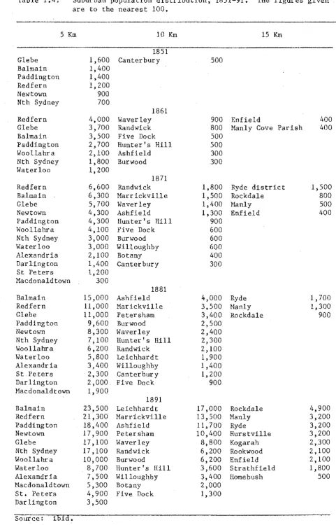
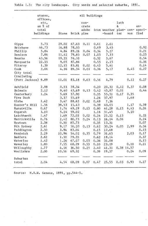
1.3 Metropolitan population distribution, 1846-91 1.4 Suburban population distribution, 1851-91 1.5 The city landscape. City wards and selected
suburbs, 1891.
l
2
2
3
4
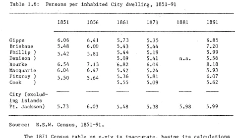
1.6 Persons per inhabited City dwelling, 1851-91 5 1.7 City population density per acre, 1851-91 5
1.8 House sizes per City ward, 1891 6
TWO Introduction 7
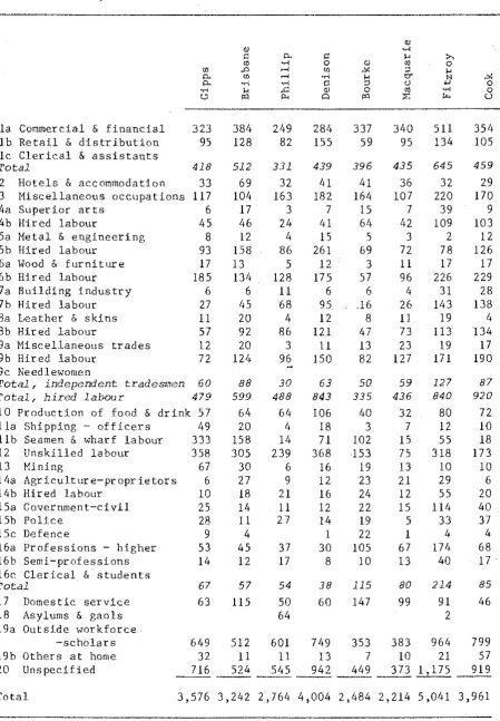
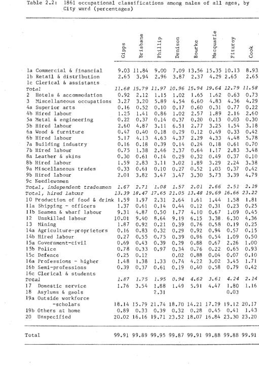
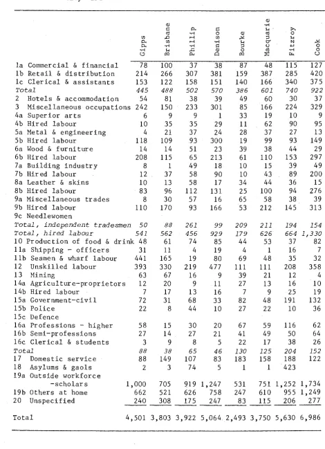
2.1 1861 occupational classifications among males of all
ages, by City ward 11
2.2 1861 occupational classifications among males of
all ages, by City ward (percentages) 12
2.3 1861 occupational classifications among females of
all ages, by City ward 13
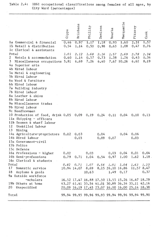
2.4 1861 occupational classifications among females of
all ages, by City ward (percentages)
14
2.5 1871 occupational classifications among males of
all ages, by City ward 15
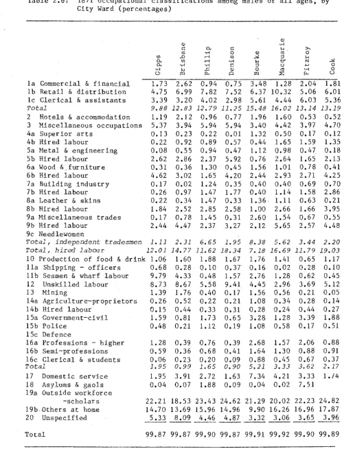
2.6 1871 occupational classifications among males of
all ages, by City ward (percentages) 16
2.7 1871 occupational classifications among females of
all ages, by City ward 17
2.8 1871 occupational classifications among females of
all ages, by City ward (percentages) 18
THREE Introduction 19
3.1 Single railway fares to suburban stations on the
Parramatta, Illawarra, and northern lines, 1858-88 23 3.2 Workmen's weekly railway ticket concessional fares
on the Parramatta and Illawarra railway lines during
FOl:R
3.3 Or.lnibus single journey fares, 1861-88
3.4
Tramway single journey fares, 1881-83.5 Workmen's concessional tramway fares, 1890
3.6 Approximate oranibus journey times in minutes, 1866,
1876, and 1889
3.7 Approximate journey tiraes between selected suburban stations on the Parramatta and Illawarra railway lines, 1858-88
3.8 Omnibus timetables, 1878-80
3.9 Railway timetables on the Parramatta line, 1858-88
3.10 Railway timetables on the Illawarra line, 1884-8
4.1 Death rates for all ages, per 1,000 of mean population, 1857-91
4.2 Death rates among five year olds, per 1,000 of mean population, 1871-91
4.3 Deaths under five years of age as a percentage of total deaths, 1857-91
4,11 Deaths under five as a percentage of total deaths in each City ward, 1872-81
4.5 Deaths in the City among children aged under one to five, as a percentage of total deaths under five, 1872-81
4.6 Death rates among infants (under one year old) per 1,000 births, 1871-91
4.7 Registrar General's mortality classifications. Major
v 25 26 26 27 28 29 30 30 31 32 33 34
34
35causes of death in the City, 1874-81 36
4.8 Diarrhoea-related mortality in the City, 1874-81 39
FIVE Introduction 41
5.1 Municipal electors as a proportion of total adult
population in the City and selected suburbs, 1861-91 SO 5.2 Proportion of non-resident municipal electors to
total electors in selected Sydney suburbs, 1860-90 51 5.3 Non-resident electors in selected suburbs who voted at
the last municipal elections, as a percentage of the
5.4 Electors in selected suburbs who voted in the last municipal elections, as a percentage of total
electors, 1860-85
5.5
Percentages of each category of electors in selected suburbs who voted at the last municipal elections, 1871-855.6
Distribution of electoral influence in selected suburbs, 1871-90SIX 6.1 Yearly salaries in pounds of selected City
SEVEN
EIGHT
NINE TEN
ELEVEN
Corporation officers, 1857-99
6.2
Written notices served and prosecutions undertakenby the Inspector of Nuisances for the abatement of health nuisances, 1867-90
City buildings condemned by the Corporation as unfit for human habitation, 1879-96
Distribution of recorded smallpox cases in City and suburbs, 1881
Occupations of householders in condemned buildings Movements of householders displaced by Corporation demolition orders
Chronicle of principal events
Select Bibliography
53
54
55
57
58
59
60
61
69
73
PLATES
1 Metropolitan Sydney in 1890
2 Smith And Hinton's Map Of Sydney And Suburbs 1854
3 Map Of Port Jackson And City Of Sydney, Shewing The Adjacent Municipalities, 1867
4 From the Town Hall, looking southeast, 1873
5 York Street, 1873, looking north
6 Darling Harbour, from St Philip's tower, 1878
7 From the Town Hall, looking southwest, 1873
8 Darling Harbour, from Pyrmont, 1870
9 Australian Gas Company Works, 1870
10 Guthbert1s Shipyard, 1871
11 Darling Harbour, c.1880
12 Darling Harbour, c.1887
13 Sussex Street, n.d.
14 Washington Place, 1875?
15 George Street, c.1899
16 Building base lines in the Albion Estate, Surry Hills, 1887
'17 Building base lines in the Albion Estate, Surry Hills, 1887
18 Building base lines in the Albion Estate, Surry Hills, 1887
19 The head of Darling Harbour, n.d.
20 The Haymarket, looking north, c.1895
21 Park Street, c.1880
22 Bridge Street frontages, 1889
23 Back premises, Bridge Street, 1889
24 Queen's Place, n.d. (1875?)
25 Building base lines in the Rocks, 1889
26 Back premises in the Rocks, 1900
27 BuHding base lines in Washington Street, 1887
28 Darling Harbour, c.1880
29 Building base lines, Macleay Street, Pott' s Point, 1885
30 Sussex and Erskine Streets, c.1876
31 Sussex Street, c.1875
32 Lynch's court, off Clarence Street, 1875?
33 Plan Of The City Of Sydney, 1880
34 Numbers 25-7 Day Street, 1900
35 Millers Point Corner, 1901
Source:
A.N.L. (1, 3, 6, 8, 9, 10, 11, 12, 13, 15, 19, 20, 21, 28, 35).
M.L. (2, 4, 5, 7, 14, 16, 17, 18, 24, 25, 27, 29, 30, 31, 32).
s.A., N.s.w. (22, 23).
Fielding's Visitors' Companion, Sydney, 1879 (33).
viii
M. Kelly, A Certain Sydney 1900' A Photographic Introduction To A Hidden
A.B.C.N. A.D.B. A.M.G. A.N.L. D.T. E.N.
J .(N.s.w. L.C.)
M.L.
N.s.w ..
N .. S.W .. B .. H., P ..
N.s.w.
P.D.-
-P.!1.c.c.s.
R.A.H.S., J, & P.
R .. c.c.s .. R .. , P.R.
R.C.c.s .. R., R ..
R.C.M.Q.S.
R.C.T.F.
R.S.N.s.w., J. & P.
S.A.' N ..
s.w.
ABBREVIATIONS
Australasian Builder and Contractor's News Australian Dictionary of ~~ography
Australasian Medical Gazette
Australian National Library, Canberra Daily Telegraph
Evening News
Journal of the N.S.W. Legislative Council (commences in 1856 with the introduction of responsible government)
Mitchell Library, Sydney New South Wa1es
Minutes of Proceedings of the N.s.w. Board of Health
(mss. volumes in S.A., N.S.W.)
N.S.I>'._~ Parliamentarv Debates (commence 1881) Proceedings of the Municipal Council of the City of Sydney (printed volumes start in 1887)
Journal and Proceedings, Royal Australian Historical Society
ix
Progress Report of the Royal Commission on City and Suburban Railways, in
v.
& P.(N.s.w. L.A.), 1891-2, vol .5Report of the Royal Comi:d.ssion on City and Suburban Railways, in ibid.
Report of the Royal Commission on the Management of the Quarantine Station, North Head, and the Hulk 'Faraway', in ibid., 1882, vol.2
Report of the Royal Commission to Inquire into the Recent Alleged Tramway Frauds, and to Report upon
the Most Efficient Means for Securing the Tramway Revenue from Misappropriation in the Future, in ibid., 1888-9, vol.2
Journal and Proceedings, Royal Society of N.s.w. (title varies)
s
.H.s.c.c.w.c.M.
S.C.C., F.C.R ..
S.C.C., L.R.
S.C.C., L.S.
S.C.C., M.P.M.
S.C.C., P.
s.c.w.M.
(up to 12th R.)
S.M.H. (Herald_)
v.
&P.(N.s.w.
L.A.)v.
& P.(N.s.w. L.C.)Report from the Select Committee on Common Lodging
Houses, in
v.
&
P.(N.s.w. L.A.), 1875-6, vol.6Report from the Select Committee on the Condition
of the Working Classes of the Metropolis, in ibid.,
1859-60, vol.4
Sydney City Council, Finance Committee Reports
(mss. volumes in Town Hall Archives)
Letters Received (mss. volumes in Town Hall
Archives. Unless otherwise indicated, all reports
and letters are addressed to City alderman and/or
the Mayor.)
--- Letters Sent (mss. volumes in Town Hall
Archives)
--- Miscellaneous Printed Material (boxed
material in Town Hall Archives)
--- Minutes of Council Proceedings (mss. volumes
in Town Hall Archives)
Report from the Select Committee on the Working of
Municipalities, in
V.
&
P.(N.S.W. L.A.), 1873-4,vol.5
Sydney City and Suburban Sewage and Health Board
(1st to 3rd Reports are in
v.
&
P.(N.s.w. L.A.), 1875, vol.4; 4th to 11th are in ibid., 1875-6,vol.5; 12th is in ibid., 1876-7, vol.3)
.§xJney Morning Herald
Votes and Proceed~ngs of the N.S.W. Legislative
Assembly (commencing with the first Parliament
elected under responsible government, in 1856)
Votes and Proceedings of the N.S.W. Legislative
Council (1824-55)
xi
ACKNOWLEDGEMENTS
I owe much to help given by librarian and archival staff in Sydneyand Canberra. Special thanks are due to the staff of the Petherick Advanced Studies Reading Room, the Newspaper Reading Room, and the Pictorial
Collection in the Australian National Library. In Sydney, the City Council archivist Hr Ken Smith cheerfully helped me in the seemingly never-ending
task of locating and then carrying hundreds of dirty manuscript volumes from the basement of the old Town Hall to his sixth-storey rooms in the new office-block behind.
Mr Alan Roberts, tutor at Macquarie University, was generous in his assistance. While researching and writing the thesis, I was helped by the comments of staff and fellow research scholars in the Research School of Social Sciences, A.N.U. Dr J.J. Eddy, Dr A.W. Hartin, Dr F.B. Smith, and Dr C.T. Stannage waded through a succession of draft chapters. Professor K•S· Inglis gave advice and together with Dr Eddy lent encouragement when it was most needed. Mrs Lois Simms filled many gaps in my knowledge concerning
SYNOPTIC INTRODUCTION
This is a study in human relationships - of the way in which the
ignorance and subsequent fears and prejudices which shape human perceptions of one another are incorporated into the social ties binding together the community as a whole. The thesis is confined geographically to the inner city area within the administrative boundaries of the Sydney City
Council.! It takes as its core-period the years between the disease alarms early in 1875 and the smallpox epidemic during the second half of 1881, and from that perspective views the broader sweep of time from mid-century until the early 1890s. It shows an urban community in whose expanding economy and aggregation of population were contained forces of fragmentation and division - geographical, social, and psychological.
City growth at a rate faster than the enactment of regulatory controls and provision of local services had been accompanied by a proliferation of aesthetic and sanitary nuisances, caused for example by the expansion of industry, and deficiencies in garbage collection, in drainage and water services. Networks of abutting courts and passageways developed off City main streets, crowded with insanitary tenements and groups of decaying cottage-dwellings, relics from the city's past. The consequent anxieties about city ill-health, and recurring alarms about the likely appearance of epidemic disease, were expressed in a generally-felt dissatisfaction with the achievements of local government sanitary administration. As the experiences of CHOs in attempting to remedy sanitary nuisances make plain, the City Corporation's performance in the field of public health was
limited by its powerlessness to undertake necessary sanitary initiatives
independently of Parliament. Many outside critics however, aware only of the continuing deficiencies in City health regulation, called for the City Council's replacement by a more energetic metropolitan municipal council,
or for its subordination to the directions of government-appointed experts on a board of health.
Contemporary understanding of the nature of disease, influenced by miasmic or filth-based explanations of illness, focused community anxieties about disease upon the working class districts of the inner City.
1. See Plate 33. The area within these boundaries is referred to
throughout the thesis as the City; I use the word 'city' to refer to the total metropolitan area.
2
The resulting sanitary investigations of these little-known neighbourhoods presented a generalised picture of squalor and unwholesomeness.
Apprehensions about disease, together with middle class rationalisations for the existence of poverty, and at the individual level a psychological need among people of all classes to have someone else to look down upon, in
turn produced a distorting, stereotyped image of an alien and menacing subgroup of debased humanity within the community - the urban lower orders. The emergence and subsequent impact of the image of the lower orders upon
the direction of sanitary endeavour and of public health policy in Sydney forms the core of this thesis.
This is the first doctoral thesis to have been based upon the
manuscript material on city health in the Sydney Town Hall archives. The City Council's sanitary staff has never before been studie~. The CHOs are
largely forgotten men. In their many hundreds of reports, however, there lies an invaluable .source of infonnation on life - and death - in a
nineteenth century city.
CHAPTER ONE The Urban Environment
I
Port Jackson, Sydney. The famed grandeur of the setting of the New South Wales capital held William Archer spellbound when as a young man of twenty the English literary critic visited the city in I876. Harbour and shoreline together "combined to form a picture of indescribable beauty". And the city itself, as he remembered seeing it early one morning when the sun was rising through a light mist,
lay piled up, terrace upon terrace, with the mist turning from grey to gold and from gold to fl.re over the gigantic masses of building which crowned the heights. It reminded me of the great cities of the
imagination - Carthage or Palmyra •••
r
shall never forget either the one scene or the other.ISydney was then a sprawling metropolis of some I67,000 people, the second largest city in the Australian colonies. Melbourne, capital of the neighbouring southern colony of Victoria, had passed Sydney in population in the wake of the Victorian gold discoveries of the I850s, and was not overtaken by its older rival until almost the turn of the century. 2
Since the I860s, however, the gap between the two biggest cities had been steadily dwindling, and it was to Sydney that a traveller in 1896 paid tribute as "the queen of the Southern Hemisphere, and the centre of commerce for this vast continent ... 3
The reason, said visitors, was the city's port. The port of Sydney, blessed with the spacious harbour that Archer so admired, and situated at the terminus of the colony's railway network, dominated N.s.w. commerce.4 That dominance was reflected in a rapidly growing population. In 1851 Sydney and suburbs had totalled some 54,000 souls. lly 1891, metropolitan
I. W. Archer (R, Stanley, ed.), Tourist to the Antipodes, St. Lucia, I977, pp. 9-10.
2, V. & P. (N.S.W. L.A.), 1882, vol. 3, p.671; J, W. McCarty, 'Australian Capital Cities in the Nineteenth Century', Australian Economic History Review, vol.IO, (1970), p.Il9; see also T.A. Coghlan, The Wealth And Progress Of New South Wales \900-01, Sydney, 1902, p.947.
3. N. Gould, Town and llush, (London, 1896), Penguin Colonial Facsimiles, I974, p.73; see R.V, Jackson, Australian economic development in the nineteenth century, Canberra, 1977, p.100,
4. See H. Cornish, Under the Southern Cross (Madras, 1880), Penguin Colonial Facsimiles, I975, pp.248-9; Gould, Town and llush, p.73; B.I. Millin, 'Sydney Harbour and Some Shipping Reminiscences', R.A.H.S., J. & P., vol.23 (I937), pp.310-15; see also the tally of shipping in Port Jackson on census day, I89I, in T.A. Coghlan, General Report On The Eleventh Census Of New South Wales, Sydney, I894, p.258.
population was little short of the 400,000 level,5 Six metropolitan
suburbs, in addition to the City proper, were each shown by the 1891 census to be more populous than was the colony's second largest port, the city of Newcastle. The Government Statistician, Timothy Coghlan, concluded that
taken together, the residents of metropolitan Sydney considerably
outnumbered the combined total of inhabitants from all other towns in the colony, and equalled the whole population of rural N.S.w.6
Metropolitan Sydney was described by Coghlan as extending over some 150 square miles by the early 1890s, reaching westwards almost to Parramatta and including 35 suburban municipal districts
.7
Only 40 years before, at mid century, visitors to Sydney had found settlement largely confined to the inner City,Harbour east to concentrated in
on a tongue of land extending from the base of Darling
l
Woo1(.:omooloo and Rushcutters Bays. Settlement then was the western City, from Circular Quay south and west along the length of the major thoroughfare, George Street, across to Darling Harbour, In Gipps Ward, behind the warehouses along the western edge of Circular Quay, lay the already ageing working class district of "the Rocks". Brisbane Ward, extending westwards from George Street down the length of Darling Harbour, was becoming lined along much of its harbour shoreline with wharves. The hay, corn, and cattle markets, situated in adjoining Phillip Ward near the head of Darling Harbour, were on the
southernmost outskirts of close settlement. Open meado\.ls lay from here to the nearby suburban hamlets of Redfern and Glebe, In the City's Denison Ward, extending from Darling Harbour's southern base up the Pyrmont peninsula along its western shores, scattered small buildings stood amid large tracts of still undeveloped land.8
Visitors to the Hay Market, looking across Elizabeth Street towards the walls of Darlinghurst Gaol on the City's eastern boundary, would have seen more acres of vacant land. Subdivision of the large Riley Estate had criss-crossed the area with rough streets, and from near the City's
southeastern boundary, an irregular band of housing straggled along between Crown and Dowling Streets towards inner Sydney. On the City's east, the
5. Appendix One, Table I.I.
6. Coghlan, General Report, p.119. It was a pre-eminence far more marked than that of London over England and Wales; G. Best, Mi.cl-Victorian Britain 1851-75, London, 19711 p.7. See Appendix One, Table I.I.
7. Coghlan, General Report, p.119; see Plate I.
8. Plate 2; Appendix One, Table 1.2; see T.L, Mitchell, Trigonometrical Survey of Port Jackson, 1853; Smith and Hinton, Map of Sydney and Suburbs, Sydney, 1854; Woolcott and Clarke, Map of the City of Sydney, Sydney, 1854.
higher ground of Darlinghurst was already dotted with the mansions and large gardens of
between Circular
the well-to-do, and on the rising ground opposite, running
l
Quay and Wool\;'omooloo Bay south through the heart of the City, lay the park and recreation belt of the Domain and Hyde Park.
Between the two ridges, the many still vacant allotments of the
1
Woo~omooloo valley were being rapidly covered with houses for the working classes.9
Expanding City trade brought with it considerable alterations to the Sydney landscape over the following decade. In the neighbourhood of busy Circular Quay, new wool stores, large and often elaborately ornamented stone structures, had transformed the City skyline. The Sydney Exchange nearby, opened by the Governor in 1857, was described proudly by guide books as a massive and imposing structure offering all the facilities available in the kindred institutions of London and Liverpool. Along the central City blocks of George Street, the rising tide of commercial
activity could be charted in the number and imposing appearance of the financial institutions constructed there since the mid 1850s.10
Not nearly so apparent were the internal lanes and alleyways behind the facades of those central City blocks, where working people, like the
lumpers to be seen toiling at Circular Quay, had their homes.11 More noticeable to casual passers-by, the ageing district to the immediate west and southwest of Circular Quay was coming "to have a very old-fashioned and
9, Mitchell, Trigonometrical Survey; see the plan of the Parish of
Alexandria in
w.
M. Brownrigg, 'Maps comprising the various parishes of the County of Cumberland',s.c.c.w,c.M.,
qu.77, 89, p.1288; see also qu.238-9, p.1295.10. R. P. Whitworth, Bailliere's New South Wales Gazetteer and Road Guide, Sydney, 1866, pp.518, 525, 527; S. T. Leigh & Co., The Handbook to
Sydney and Suburbs, Sydney, n.d. (c.1867), pp.15, 36; see the 1863 reference to Circular Quay in P. Mukhanov (trans. V. Fitzhardinge),
'Sydney', R.A.H.S., J. & P., vol.SI (1965), p.296.
11. See the Bourke Ward statistics in Appendix Two, Tables 2.1 and 2.2. As the City Council rate collector explained in 1859, "The worst cases of poverty are to be seen in the back places, the lanes, and yards that lead off the main streets, and are not likely to be observed by a
passer by,"
s.c.c.w.c.M.,
qu.258, p,1296; also qu.215, p.1294;qu.219-223, pp.1294-5; qu.628, p.1315. A network of such alleys, for example Robin Hood tane, lay behind the Pitt Street facade opposite the Sydney Exchange; ibid., qu.326, p.1299. Across the intersection of George and Bridge Streets from the Exchange was the entrance to the working class neighbourhood of Queen's Place, known to the CHO as one of the most unwholesome spots in Sydney; ibid., qu.611-3, p.1314; qu,643, p.1317; also qu,230, p.1295; see Plate 24.
decayed appearance".12 The similarly run-down Rocks district nearby, a favourite home for shipping, dockside, and general unskilled labour, was also becoming regarded as a particularly unwholesome working class
area.13
The bustling dock area close at hand, stretching along the eastern shore of Darling Habour, formed the hub of coastal trade and transportation up and down the K.S.W. coast, and manufacturing industries were also
accumulating in the district,14 Sussex Street, extending from Margaret Street behind the docks down the remaining length of Darling Harbour to the Haymarket, was becoming one of the major commercial arteries of the
City.IS· The district traversed by it and the parallel thoroughfares, Kent and Clarence Streets, was also the most characteristically working class residential area in Sydney. It was likewise becoming one of the most unwholesome,16 Industrial development along the western shores of
Darling Harbour, now linked by toll bridge to the inner City, was also said to be gradually turning Pyrmont's wastelands into a working man's
"fa.ubourg", 17 Denison Ward, indeed, contained by far the biggest
12, Leigh, The Handbook to Sydney, p.36. The neighbourhood was already by the early 1860s being described as Sydney's Chinese quarter; J, W. Waugh, The Stranger's Guide To Sydney, Sydney, 1861, p.10; see also E,
Burton, Visitor's Guide to Sydney, Comprising Description Of The City And Its Institutions. With Which Is Incorporated The Tourists'
Handbook; And The Resources Of New South Wales, 2nd ed., Sydney, 1874, p. 28.
13, See the Gipps Ward statistics in Appendix Two, Tables 2.1 and 2,2; see also s.c.c.w.c.M., qu.215, p.1294; qu.259, p.1296.
14. Waugh, The Stranger's Guide, p.15; Whitworth, Bailliere's p.518; see Plate7,
15, The surrounding area contained the second largest commercial and retailing population in the City after the central business districts of Bourke and Macquarie wards; see the Brisbane Ward statistics in Appendix Two, Tables 2,1 - 2.4.
16. See ibid.; the Inspector General of Police remarked in 1859 that
T'he description of dwellings occupied by the working classes
in Druitt, Clarence, and Sussex Streets, and in the lanes
and alleys abutting on tho·se streets is, both as regards
ventilation, drainage, and cleanliness, most defective.
S.C.C.W.C.X., qu.78, p.1288; also qu.647, p.1318; qu.1965, p.1402. 17, Leigh, The Handbook to Sydney, p.60, also p.61; the district had
become "a favourite resort of working men whose business at the foundries, patent slip, and building yards, renders it a place of convenient. •• residence", Whitworth, Balliere's p .• 519; see the advertisement for the Pyrmont Bone Dust Steam Mills in ibid.
Darling Harbour as far north as Liverpool Street was being reclaimed for railway yards; Select Committee on Railway Through Ultimo Estate,
v. & P. (N.S.W. L.A.), 1865, vol.I, qu.30, 33 p.824. At the north of
Pyrmont, the Australian Steam Kavigation Company works employed some
population of metal workers in the City, and was home to more skilled wage workers than was any area save the rapidly growing Surry Hills district on
the City's southeast, With the other western districts of Gipps and Brisbane Wards, it also contained over half of the general unskilled labouring workforce in the City.18
Phillip Ward, to the south of Pyrmont and Darling Harbour, was also becoming tagged as working class and industrial, In the Chippendale
district, on the southern boundary with suhurban Redfern and alongside the City railway terminus, could be seen a steam flour mill and the refinery of the developing giant, the Colonial Sugar Refining Cornpany,19 Also to be seen along the district's back lanes, said the City missionary Nathaniel Pidgeon, were crowded and insanitary rows of houses, small in design and many without even backyards. Further north up George Street, past the gasometers of a new Australian Gas Light Company substation and the
adjoining Haymarket, the obscured interior lanes, such as Durand's Alley, worming off Goulburn Street were building a reputation for
unsavouriness.20
Sightseers passing through Riley Estate on the City's southeast, which a decade before had been mostly vacant lots, now found the thriving
community of Surry Hills, Comfortable working class dwellings were here being erected which were claimed to be as good as accommodation being offered about the inner City for double the money. Already the district was home to more wage workers than was any other ward in the City.21
Darlinghurst, on the City's eastern boundary, with its large mansions and spacious grounds was described to visitors as the most fashionable neighbourhood in Sydney,22 Woolloomooloo, lying between the higher
ground of affluent Darlinghurst and the park belt of the City centre, was by contrast not a place in which to linger. A large manual population, some of them independent craftsmen and many more wage workers and general
17 .cont.
350 people building and repairing company ships; Waugh, The Stranger's Guide, p.14; Whitworth, Bailliere's pp.465-6.
18. See Appendix Two, Tables 2.1 and 2.2.
19. Leigh, .The Handbook to Sydney, p. 7 5, and see the advertisement for James Pernell's steam mills; see also the advertisement for C.S.R. in Whitworth, Baillie.re's.
20. s.c.c.w.C.M., qu.404-10, pp.1304-5; see references to Durand's Alley in qu.627, p.1315; qu.1225-9, p,1346; qu,1965, p.1402.
21, Ibid., qu.426, p.1305; also qu,88, p.1288; see Appendix Two, Tables 2.1 and 2.2.
22, See Waugh, The Stranger's Guide, pp.43-4.
labourers, lived in the area. Parliamentary investigators reported in 1860 that
In many parts of Woolloomooloo, which have been built over during the last fifteen or twenty years, there are narrow lanes of houses with all the evils inseparable from improvident construction, insufficient living room, confined space outside, and want of drainage, in forms as aggravated as in the old cities of Europe.23 For visitors to the City, however, working class Sydney was generally out of sight and out of mind. For a dose of local plebeian colour, guide books suggested a visit to the City's bustling produce markets.2 4 The Hay and George Street markets together drew a mounting volume of farm produce from an expanding hinterland around Sydney, To the west, astride the Parramatta Road and the Sydney to Parramatta railwayline, in districts such as Five Dock, Ashfield, and Burwood, market gardens, dairies, and cattle farms had since the early 1840s gradually replaced the original bushland and now daily supplied the City. The latter 1850s had also seen the growth of small rail way villages like Petersham, Ashfield, and Burwood, as suburban settlement was attracted to the pleasant cultivated rural
surroundings prepared by the market gardeners, Similar suburban development was occurring to the east of Sydney, and in the fruit, vegetable, and dairying areas along the northern bank of the Parramatta River, at the pretty ferry stops of Ryde, Gladesville, and Hunter's Hill. The same pattern was being repeated on a lesser scale in the orchard and vegetable areas of Willoughby, Lane Cove, and Hornsby, to the north of Port Jackson,25
Access from there to the City was via the small township of St Leonards, which lay just across the harbour from Circular Quay. By the early 1860s a regular ferry steamer service every 15 minutes was enabling a small but growing number of people to commute daily to their workplaces in
23. See Appendix Two, Tables 2.1 and 2.2; S.C.C.W.C.M., p,1271.
24. Waugh, The Stranger's Guide, pp.32, 34; Whitworth, Bailliere's p.523; Leigh, The Handbook to Sydney, pp.40, 42; see also W.A.B. Greaves,
'Recollections of Old Sydney, In 1852 and Since', R.A.H.S., J,
&
P., vol,3 (1915-7), pp.411-2.25, See the description of market gardening in the Ashfield district in the Select Committee on the Petition of Peter Rawlings, V. & P. (N.S.W. L.A.), 1856-7, vol.3, pp.489-503; Whitworth, Bailliere's pp,14, 107, 207, 223, 271, 310, 486, 505; Leigh, The Handbook to Sydney, pp.63, 66; see below n.28;
w.
H. Wells, A Map Of The County Of Cumberland In The Colony Of New South Wales [Sydney, 18571], See Plate 3.,).,
~'
,-::_::"" ;,1W ~
~-"'..._ -~
f' DJJ,' f -4:8-J!<:K~ill.
''--;~ ~illy tf~~lH'!t
_o_e-d' :nr: hln1i::t>H~110;.
\ ., 11_ !;n,;
--'
'H J
the City,26 The village of Manly, at the harbour's furthest eastern reaches, near North Head, had also by the middle 1860s developed into a straggling town with several good hotels and an increasingly famous beach. The township had since the mid 1850s become "a favourite watering place", and by 1858, when the first regular steamer service began operating to Sydney, there were already a number of Manly residents with the time and the money to commute daily to their offices in the City.27
It was however along the southern harbour shores beyond Darlinghurst that the well-to-do had mostly plumped for the location of their suburban homes. A string of stately villa residences had for decades dotted the different bays along the southern shore. Expanding settlement as the
Sydney middle classes settled along and inland from the harbour now saw the district emerge as the fashionable suburb of Woollahra. Second in order of desirability was the neighbouring suburban district of Waverley, which extended inland from the harbour across to the Pacific coast. Both here and in suburban Randwick to the south, a landscape of farms and market gardens was being reshaped as villas and housing estates dotted the area.28
Commuter traffic from Randwick entered Sydney through Paddington, a suburb of nearly 3,000 people in 1861, lying alongside the City districts of Surry Hills and Darli.nghurst. Suburban settlement was overwhelmingly concentrated in a ring of such townships immediately adjoining the City boundaries. Largest of all was Redfern, only a few minute's walk beyond Surry Hills and Chippendale. Newtown, further afield, was still within walking distance of the City, as well as being serviced by omnibus and train.29 Glebe, on the City's southwestern boundary and separated from
26. Ibid; Mitchell, Trigonometrical Survey; Waugh, The Stranger's Guide, p.13; Whitworth, Bailliere's p.488, A scattering of people able to afford the high fees charged by watermen were also settling along the picturesque bays and picnic spots eastwards along the harbour
shoreline; see ibid., pp.349-50, 371.
27. Ibid., p.335; Waugh, The Stranger's Guide, p.,53; see Wells, A Map Of The County of Cumberland.
28. Mitchell, Trigonometrical Survez; Mrs Charles Meredith, Notes and Sketches of New South Wales (London, 1844), Penguin Colonial
Facsimiles, 1973, p.34; Waugh, The Stranger's Gui.de, p.56;
Whitworth, Bailliere's, pp.65, 144, 469-70, 592-3, 621; Leigh, The Handbook to Sydney, pp.48-51, 55.
29, See Appendix One, Table 1.3 and 1.4; see also Plates 2 and 3, Redfern had developed from an isolated hamlet in the early 1850s into a town of some 4,000 inhabitants by 1861; Newtown was described in 1866 as being "a favourite place of residence for gentlemen having business in
Sydney", and convenience to City workplaces was enabling a working
Pyrmont by Blackwattle Bay, was by the 1860s a long-established suburb rivalling Redfern in population, Glebe had a reputation as a popular residence for City merchants and businessmen, and Glebe Point especially was a district of considerable exclusiveness.30 Balrnain, situated on a large curved peninsula beyond Glebe that swung round above Pyrmont to face Miller's Point at the top of Darling Habour, had grown from a scattering of buildi.ngs and tracks in the early 1850s into a mixed residential and
industrial suburb of some three and a half thousand people a decade later. Steam ferries plied to and from the City every ten minutes, and a large middle class commuter population lived in the suburb. Manufacturing, however, was tempering Balmain's original exclusivist image,31
Developing commerce and industry were likewise continuing to influence the landscape and social composition of the inner City, A visitor to Sydney like Trollope, who arrived from England in 1871, would have found the City divided along generally recognised divisions of function and status. As one guide book explained during that year,
The fashionable quarter par excellence ••• (contrary to the case of London), is the East End of the city, and the suburban localities stretching beyond along the shore. Here are most of the splendid mansions, glimpses of whi.ch are caught from the harbour which they
overlook. Most of them have been erected at enormous cost, and for extent, internal grandeur, and magni.ficient grounds, are not equalled by any private residences on this side of the equator.32
29.cont.
class population to settle in the area, and in nearby Redfern; Whitworth, Bailliere's, p.423; S.C.C.W.C.M., qu.89, p.1288.
30. Whitworth, Bailliere's, p.223; see M. Salling, 'Glebe 1790-1891: A study of patterns and processes of growth', M.A., University of Sydney,
1973, Working class Glebe, on the low-lying ground around Blackwattle Swamp, was an unwholesome district that went unmentioned in guidebooks; s.c.c.w.c.M., qu.112, p.1289.
31. Plate 3; see Mitchell, Trigonometrical Survey. The ship repair complex developed in Balmain by T.S. Mort had by the 1860s become one of the industrial showpieces of Sydney; Whitworth, Bailliere's, pp. 20-1.
32. Gordon and Gotch, The Australian Handbook and Almanac for 1871, London, n.d., p.67. The northeastern districts of Bourke, Macquarie, and
Fitzroy Wards contained the highest concentration of professional people, merchants, and financiers, the greatest number of domestic servants, and the lowest proportion of unskilled working people in the City. In Fitzroy Ward, working class numbers had dropped considerably over the previous decade; Appendix Two, Tables 2,1, 2.2, 2.5, 2.6. See
s.
H. Fisher, 'Life And Work In Sydney, 1870-1890: Aspects of Social Development in a Nineteenth Century City', Ph.D., Macquarie University, 1976, pp.42-3, 51.The eastern City districts of Fitzroy, Bourke, and Macquarie Wards were all heavily white collar and professional in their social makeup. In the central City, a walk down Pitt Street from the wool stores of Circular Quay took the visitor past a line of mercantile and shipping offices to the Sydney Exchange, firmly established as "the principal place of rendezvous in the city for merchants and shippers, and business men generally," Only a quick step away were the Australian and Union Clubs. Taking a cab from the corner stand outside the Exchange, a run further down Pitt Street took the traveller past an impressive collection of finance, banking, and
insurance corporations, A turn into George Street brought into view a further vista of banking and finance houses, and the principal stores of Sydney's busy shopping centre.33
A large working class population of self-employed artisans and skilled wage workers nonetheless still lived in eastern Sydney, in Woolloomooloo and also in the central business districts of the City. The unskilled and semi-skilled labourforce that had for long been housed along the hidden back lanes of Bourke Ward had declined in numbers, but as well as
containing much of the City's social and economic elite the district's population continued to include a high proportion of shipping and general labour,34
Cook Ward on the City's southeast existed on the fringes of fashionable east Sydney. A significant white collar population of clerks from
government service and commerce, of shop assistants and professional people, lived here in Surry Hills. They were greatly outnumbered however by the area's large and quickly growing population of skilled wage workers. Heavy settlement in the district by tradespeople, especially tanners,
building tradesmen, milliners and dressmakers, had by the early 1870s made Cook Ward by far the most populous single neighbourhood in the Gity.3 5
33. Burton, Visitor's Guide, pp,73-4, and see p.32; Henry Cornish, visiting the City during the late 1870s, enthused of Pitt and George Streets, "The new banks, insurance offices, and warehouses are simply superb, ranging from four to five storeys in height, and built of
••• magnificent freestone"; Cornish, Under the Southern Cross, p. 253; The Industrial Progress of New South Wales: Being a Report of the Intercolonial Exhibition of 1870, at Sydney; together with a variety of papers illustrative of the Industrial Resources of the Colony, Sydney, 1871, p.480; J, Sands, Hap Of Sydney For 1879, Sydney, n.d. Note the large retail population in Macquarie Ward in Appendix Two, Tables 2.5 -2,8.
34. Ibid., Tables 2.5 and 2.6; see Plates 4 and 24.
35. Appendix Two, Tables 2.5 - 2.8; Appendix One, Table 1.2.
Plate 4, From the Town Hall, looking southwest, 1873
Many independent artisans, especially precision workers such as
watchmakers, locksmiths, jewellers, and printers, lived and worked to
the east of George Street, in Bourke and Macquarie Wards. Considerable
numbers of hired workmen, too, lived in the latter district,l Here,
in off-street alleyways were warehouses and scattered factories, such as
John Sands' large printing works, and bootmaking and tobacco
factories, 2
The photograph is of Macquarie Ward. George Street can be seen in
the right foreground, and Bathurst Street is obscured on the far left of
the picture. Fitzroy Ward is to be seen on the far side of Hyde Park.
The large avenue leading diagonally from the southeastern corner of the
park is Oxford Street, the busy arterial road to suburban Paddington.
On the extreme right of the photograph, among the crowded vista of
buildings to the south of Hyde Park, is located the insanitary working
class housing region about Goulburn Street.
In the foreground, squeezed behind the Australian Book Mart and the
lofty blank walls of other business establishments in George and Pitt
Streets, can be seen some of the jumbled sheds, dwellings, and workshops
among which the inner City's working class population lived. A number
of low metal (steam engine?) funnels and several large brick chimneys
are scattered through this local neighbourhood, Note also the large
factory chimney stack in the left-centre, flanking the Protestant
chapel.
1. Appendix Two, Tables 2.5 and 2.6,
2. Sands, Map Of Sydney; Progress Report from the Select Co~mittee on Employment of Children,
v.
& P. (N.S.W. L.A.), 1875-6, Vol. 6,Phillip Ward to its west was more petty commercial and industrial in character, and was correspondingly less attractive a place of residence among middle class professional people and clerical workers. Many hawkers and produce dealers lived in the Haymarket area. George Street as it turned westwards through Phillip Ward continued to be lined with retail premises, and large numbers of store keepers, female shop assistants, and needlewomen lived in the district. A very high proportion of self-employed craftsmen, bootmakers and leather workers, buildi.ng tradesmen, and workers in wood, also lived in the area. In Chippendale, the Colonial Sugar
Refinery and Tooth's Brewery were major employers. Considerably fewer skilled wage workers however lived in Phillip Ward than in Surry Hills. The. district was instead a popular home for the semi-skilled and unskilled, with high concentrations of policemen and labourers living in the area,36
Phillip Ward was regarded by the middle classes as belonging more to the west of Sydney than to the fashionable east, The great divide in Sydney was George Street. Unlike the City to the east, a district like Pyrmont for example, now becoming a "large and expanding suburb", was said jokingly by Trollope to be "not fashionable at all" ,37 Western Sydney was a district .dominated by commerce and industry. I t was also regarded by contemporaries as working class Sydney, The district, as well as
containing the heaviest concentration of population in the City, also contained its highest proportion of manual labour and only low numbers of middle class residents.38
Western Sydney was not quite so exclusively proletarian in character as middle class eastern Sydney believed. Gipps Ward was home to professional people, school teachers, and office workers, as well as to the unskilled labourer. Pyrmont, and Brisbane Ward, with its streets lined with the premises of shipping merchants, brokers, and storekeepers, both contained a large commercial and retail population, Despite their heavy concentration in western Sydney, unskilled labourers, excluding domestic servants, were outnumbered by semi-skilled and skilled working people in every western district except Gipps Ward, whose population contained a very high level of shipping and dockside labour. 39 High numbers of artisans too, were
36. Appendix Two, Tables 2,5 - 2.8; Cornish, Under the Southern Cross, p.248; Fisher, 'Life And Work In Sydney', pp.44-5.
37. S. & H.B., 11th R., qu.274, p,627; A. Trollope (P. D. Edwards, R. B. Joyce, eds.), Australia, St. Lucia, 1967, p.234,
38. See Plates 5-9; Appendix Two, Tables 2.5 - 2.8.
Plate 5. York Street, 1873, looking north
Western Sydney, stretching from George Street to Darling Harbour and the Pyrmont peninsula beyond, and from Miller's Point in the north
through Gipps and Brisbane Wards to Phillip Ward in the southwest, contained approximately half the total City population in considerably less than half the City area.l
The photograph, taken from the Town Hall, looks north up York Street towards St. Philip's church. Further afield, beyond the Observatory above Miller's Point, can be seen the northern harbourside suburb of St. Leonards, In the left background, on the tongue of land facing the tall smoking chimney of the Australian Gas Light Company's works at Darling Harbour, is the suburb of Balmain.
The ageing Central Police Court stands in the right foreground, and behind it, the George Street markets. To the east of George Street, beyond the General Post Office, silhouetted topmasts mark the location of Circular Quay. Factory stacks dominate the western City skyline. In the left foreground, on the western side of Clarence Street, is a group of old single storey buildings, relics from the City's past. In the block between Clarence and York Streets, the towering blank walls of later erections throw deep shadows among the interior maze of buildings and passageways.
Plate 6, Darling !!arbour, from St. Philip's Tower, 1878
Close-built houses and chimney pots in the foreground look out over
Kent and Sussex Streets towards the workshops and large warehouses
lining Darling Harbour. Linked to the inner City by a wooden toll
bridge is the Pyrmont peninsula. Two large factory chimneys north of
the bridge bespeak the industrial development occurring in the area.
Vacant land stretches southwards towards suburban Glebe and the City's
Phillip Ward. The heavy concentration of population in the western City
was the more remarkable since much of the Ultimo Estate at the base of
the Pyrmont peninsula was throughout the 1870s open land.l
George and Charles Hoskins opened an engineering works in Hay
Street, Ultimo, near the railway goods line at the head of Darling
Harbour, in 1875-6, The company prospered, and in the present century
started the iron and steel city of Port Kembla on the N,S,W. south
coast,2
1.
s.c.c.,
L,R,, 1876, vol. I, no. 33 (Inspector of Nuisances,Plate 7. From the Town Hall, looking southwest, 1873
One guidebook described in 1874 how all around Darling Harbour, "the clanking of hammers, the noise of hundreds of steam engines will
bespeak the numerous industries that are carried on there".l Bathurst Street cuts diagonally from the left foreground to the head of Darling Harbour. Just off the street, in the centre of the photograph, stands the tall chimney and the great expanse of saw-tooth roofing of R.N. Russell and Company's foundry. The works were described in the late 1860s as covering four acres and employing from 200 to 360 men. It was proudly said to be "the most complete iron-working establishment in the southern hemisphere",2
Sandwiched between Russell's, and the other large commercial and ind us tr lal premises situated about the south of Dar ling Harbour, stand closely packed rows of two storey tenement buildings. A long tenement row stretching towards the harbour to the right of the photograph marks the working class neighbourhood of Washington Street,3 From several of the many factory furnaces that domi.nate the area, clouds of smoke are rising.
Beyond the Darling Harbour railway line and the scattered buildings on the Ultimo Estate lies suburban Glebe, and .in the left background, the tall silhouette of Sydney University,
1. Burton, Visitor's Guide, p.101.
2. ·Leigh, The Handbook to Sydney, p,76; see also the advertisement on p.19.
Plate 8. Darling Harbour, from Pyrmont, 1870
Darling Harbour's eastern shore was a jumble of wharves and storage sheds, whose access roads and lanes became bottlenecked daily with commercial traffic. Timberyards and sawmills, shipbuilding, a woollen mill, flourmills, a scattering of foundries and engineering works, a galvanising factory, and a chemical works, were located among the
warehouses and look-alike tenement rows extending from the harbour east to George Street .1 A jet of smoke or steam escapes from a factory vent in the photograph's middle background. On Pyrmont, a horse grazes among paddocks near the harbour toll bridge. Near at hand stands the chimney stack of Webb's Metallic Colour Works,
Plate 9. The Australian Gas Company Works, 1870
The gas company works covered a large block of ground at the
northern end of Sussex Street, A ship, probably a collier, is berthed at the company wharves. A touch of colour tempers the industrial
landscape, provided by the patterned curtain in the second storey window of a house in nearby Jenkins Street .•
Detached dwellings of several stories and short housing blocks
spread in moderate densities along the shore opposite, on either side of the Pyrmont ferry jetty. A commuter paddle steamer stands off from the shore, Close by, an ocean-going steamer is berthed at the Australian Steam Navigation Company works. Russell's foundry in the south of Darling Harbour, the Australian Steam Navigation Company industrial complex at Pyrmont, and Mort's engineering yards across the water in nearby Balmain, together employed over 1,000 workers.I
OJ .µ
"'
r lPlate l O. Cuthbert' s Shipyard, 1871
The population of Gipps Ward contained the"highest proportion of
carpenters and shipwrights of any area in the City. Like most skilled
working people living in western Sydney however, they were not
independent tradesmen but employees of the workshops and factories
located in the western City,l One such was Cuthhert's yard, situated
in the north of Darling Harbour, off Kent Street. South along the
harbour shore stand the two chimneys of the Australian Gas Light
Company, A smoking chimney stack is visible further south. Ships line
the harbour wharves. The Pyrmont peninsula is located on the right of
the picture,
living in Phillip Ward, but the bulk of self-employed tradesmen lived in Macquarie, Bourke, and Fitzroy Wards, to the east of George Street.40
The western City district of Denison Ward was home to the second largest skilled wage earning workforce after Surry Hills, its rapidly growing population swelled especially by the large numbers of skilled factory hands who settled in Pyrmont from nearby engineering works. The proportion of skilled working people living in western Sydney as a whole, however, was slowly declining. Greater numbers lived elsewhere. By contrast, some two thirds of the City's general unskilled and shipping labourforce was located in the west, and as commercial and industrial enterprises in the district increased in size, that proportion was increasing.41 Overall, the consequence of developments in the City economy during the 1870s was a firming demand for unskilled labour
generally, coupled with diminishing opportunities for self employment. In common with the experiences of working class communities in other
nineteenth century cities, opportunities for upward social mobility were limited, nor were they increasing.42
Social realities jarred with public images of City expansion during the 1880s. Industrial and commercial development during the decade confirmed western Sydney, in the words of one proud businessman in 1890, as "the workshop of the metropolis".43 To the east, along the City's major thoroughfare, George Street, visitors were urged to note the handsome shops, and the imposing facades in Florentine, Roman, and Greek styles belonging to branches of the dozen or more banking institutions established in the City. With the price of such City property becoming so expensive, it was said, Sydney was following the example of New York, with buildings of seven or eight floors becoming common.44 In Pitt Street,
40. Brisbane Ward, which in 1861 had contained the second largest number of self-employed artisans in the City, a decade later shared with Gipps and Denison Wards the smallest populations of independent craftsmen in
the City; Appendix Two, Tables 2.1, 2.2, 2.5, 2.6. 41. Ibid,
42. Fisher, 'Life And Work In Sydney', pp.72-141. See also s. Thernstrom, Poverty and Progress: Social Mobility In A Nineteenth Century City, Cambridge (Mass.), 1964, esp. ch.4; S. Thernstrom, The Other
Bostonians: Poverty and Progress In the American Metropolis 1880-1970, Cambridge (Mass.), 1973.
43. R.c.c.s.R., P.R., qu.695, p.238; see Plates 11-13.
44. Gordon and Gotch, The Australian Handbook, London, 1888, p.230; Reuss and Halloran, City of Sydney [Plan of the] Chisholm Estate. For
Auction Sale at 11 30 o'clock on Monday 4th December 1882 (Sydney,
Plate 11. Darling Harbour c.1880
The Pyrmont peninsula was dominated by the Australian Steam Navigation Company's engineering complex, and the works of the
Australian Sugar Company.! A wide sweep of housing is visible on the peninsula through the industrial pollution, Also visible beyond the Australian Steam Navigation Company's works in the right middleground are Johnston's Bay and suburban Balmain.
In the foreground, a group of old single storey cottages huddles between the larger buildings facing Sussex Street and a tenement block extending down a passageway off Kent Street, A puff of smoke escapes from a metal funnel among the storeyards and buildings of the coastal shipping companies located beyond the Pyrmont bridge. North of the bridge, alongside a storage shed belonging to the timber merchant J, Booth, smoke plumes from the funnel of a steamer berthed at one of the inter-colonial wharves.
Plate 12. Darling Harbour c,1887
Darling Harbour's southern foreshores on Pyrmont had during the
1870s and 1880s been given over to railway shunting yards and storage
sheds, The harbour's eastern shoreline was one mass of wharves, with
behind them a maze of iron and wooden warehouses and shipping offices,
courts and passageways, stables, timber and coal yards, sawmills,
foundries, steam mills, and other manufacturies. Offices and bond
stores of stone and brick crowded in behind.I Standing on the skyline
are the Town Hall and St. Andrew's cathedral.
Plate 13. Sussex Street, n.d.
Travellers who braved the often congested commercial traffic along
Sussex Street passed along lines of shops and offices occupied by ship's
chandlers, commission agents, produce salesmen and tradesmen, with at
each intersection a cluster of hotels.I Similar sights were to be
seen along Kent and Clarence Streets, running parallel, York and
Clarence Streets were along the length of Darling Harbour
literally covered with large employing establishments.
Clarence-street is rapidly becoming the most important commercial street in Sydney, Then there is Sussex-street, which for extent of traffic and general business activity is unequalled by any street that ever I heard of, unless it is Lower Thames-street, in
London.2
Commercial traffic along Sussex Street was said to be "enormous, a
constant stream of vehicles pouring into it from all directions" as
draymen shuttled goods to and fro between the docks and the wider
metropolis, and distributed cargoes arriving at the Darling Harbour
railway yards to their different destinations among Sydney shipping
stores,.3
1. Gibbs and Shallard, Illustrated Guide, p.38; City and Suburban Plan Publishing Co., City of Sydney 1888.
2. R.c.c.s.R., P.R., qu.695, p.238; qu.1365, p.286.
3. Gibbs and Shallard, Illustrated Guide, p.38; Second Report Relating to the Proposed Railway to Connect the North Shore Railway with Port Jackson at Milson's Point,
v.
&
P. (N,S,W, L.A.), 1890, vol.6,visitors saw more banking offices, mercantile houses, and the many
headquarters of anglo-colonial insurance companies, all of them boasted to
be "costly, artistically designed buildings, of contrasting styles",45
The Exchange, much enlarged, was invited to be admired for its "huge
appearance", and a few steps further north brought into view the overseas
steamer wharves, the bond stores, and wool warehouses about Circular Quay.
The massive wool store of Mort and Company on the Quay's southc eastern
boundary, and the larger of its fellows nearby, were said to be among the
most substantial and elegant buildings in the City, and for visitors and
residents alike epitomised the economic vigour that had sustained Sydney's
rapid growth. 46
I I
Sydney was not only an artifact, however, and a visitor standing at
Circular Quay in the late afternoon would have seen great masses of people
crowding the streets and pavements. In front of the pleasant stone Customs
House, queues of people stood waiting, scanning the approaching traffic for
the light blue and white of the omnibus service to suburban Waterloo, the
green for Glebe Point, and the green and white of the bus for Forest Lodge.
At the quayside, queues filed aboard steam ferries bound for the North
Shore.47 More crowds formed at the Darling Harbour end of King Street,
by the Parramatta River steamer terminus, whilst others headed down Erskine
Street to the landings of the Balmain and Pyrmont ferries.48 They were
all on their way home.
44 ,cont.
1882); Surveyor General's Office, Map of Plan Publishing Co., City of Sydney 1889. editorial p.7; City Architect's and City Report, p.9, P,M.c.c.s., 1889.
45. Gibbs, Shallard, Illustrated Guide, p,31.
the City; City and Suburban S.M.H., 23.10.1883,
Buildings Surveyor's Annual
46. Ibid., p.51 and see p.42; Gordon and Gotch, The Australian Handbook, p.230; Surveyor General's Office, Map of the City; Department of Public Works, Plan of Darling Harbour; Sydney and Suburban Plan Publishing Co., City of Sydney 1888.
47, See the bus stands and ferry wharves in Sydney and Suburban Plan
Publishing Co., City Of Sydney 1888; for the colours of the different bus lines, see Supplement to the N.S.W. Government Gazette, 1874, vol.I, no.104 (6 May), p.1380; see the accounts of passenger traffic on the North Shore ferries in R.C.C.S.R., P.R., qu.806, p.244;
qu.1729-30, p.321.
48. Department of Lands, City Series, M.L.), section 55
of Sydney, 1883+ (1887); see the
(Metropolitan Detail estimates of passenger