Proceedings of the Integrated Ocean Drilling Program, Volume 302
Abstract
The first scientific drilling expedition to the central Arctic Ocean was completed in September 2004. Integrated Ocean Drilling Pro-gram Expedition 302, Arctic Coring Expedition (ACEX), recovered sediment cores to 428 meters below seafloor (mbsf) in water depths of ~1300 m, 250 km from the North Pole.
Expedition 302’s destination was the Lomonosov Ridge, hypothe-sized to be a sliver of continental crust that broke away from the Eurasian plate at ~56 Ma. As the ridge moved northward and sub-sided, marine sedimentation occurred and continues to the present, resulting in what was anticipated from seismic data to be a continuous paleoceanographic record. The elevation of the ridge above the surrounding abyssal plains (~3 km) ensured that sediments atop the ridge were free of turbidites. The primary sci-entific objective of Expedition 302 was to continuously recover this sediment record and to sample the underlying sedimentary bedrock by drilling and coring from a stationary drillship.
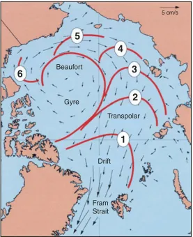
The biggest challenge during Expedition 302 was maintaining the drillship’s location while drilling and coring in 2–4 m thick sea ice that moved at speeds approaching 0.5 kt. Sea-ice cover over the Lomonosov Ridge moves with one of the two major Arctic sea-ice circulation systems, the Transpolar Drift, and responds locally to wind, tides, and currents. Until now, the high Arctic Ocean Basin, known as “mare incognitum” within the scientific community, had never before been deeply cored because of these challenging sea-ice conditions.
Initial results reveal that biogenic carbonate is present only in the Holocene–Pleistocene interval. The upper 198 mbsf represents a relatively high sedimentation rate record of the past 18 m.y. and is composed of sediment with ice-rafted debris and dropstones, suggesting that ice-covered conditions extended at least this far back in time. Details of the ice type (e.g., iceberg versus sea ice), timing, and characteristics (e.g., perennial versus seasonal) await further study. A hiatus occurs at 193.13 mbsf, spanning a 25 m.y. interval from the early Miocene to the middle Eocene between ~18 Ma and 43 Ma. The sediment record during the middle Eocene is of dark, organic-rich biosiliceous composition. Isolated pebbles, interpreted as ice-rafted dropstones, are present down to 239 mbsf, well into this middle Eocene interval. Around the lower/middle Eocene boundary an abundance of Azolla spp. oc-curs, suggesting that a fresh and/or low-salinity surface water
set-Expedition 302 summary
1Expedition 302 Scientists
21Expedition 302 Scientists, 2006. Expedition 302 summary. In Backman, J., Moran, K., McInroy, D.B., Mayer, L.A., and the Expedition 302 Scientists. Proc. IODP, 302: College Station TX (Integrated Ocean Drilling Program Management International, Inc.). doi:10.2204/
iodp.proc.302.101.2006
2Expedition 302 Scientists’ addresses.
Chapter contents
Abstract . . . 1
Introduction . . . 2
Synthesis . . . 3
References . . . 7
Figures . . . 9
Proc. IODP | Volume 302 2
Expedition 302 Scientists Expedition 302 summary
ting dominated the region during this time period. Although predrilling predictions based on geophysi-cal data had placed the base of the sediment column at 50 Ma, drilling revealed that the uppermost Paleo-cene to lowermost EoPaleo-cene boundary interval, well known as the Paleocene/Eocene Thermal Maximum (PETM), was recovered. During the PETM, the tem-perature of the Arctic Ocean surface waters exceeded 20°C.
Drilling during Expedition 302 also penetrated into the underlying sedimentary bedrock, revealing a shallow-water depositional environment of Late Cre-taceous age.
Introduction
Geological setting
Ever since Bruce Heezen and Maurice Ewing recog-nized, in their 1961 paper, that the mid-ocean rift system extended from the North Atlantic into the Arctic Ocean, it has been assumed that the Lomonosov Ridge (Fig. F1) was originally a conti-nental fragment broken off of the Eurasian continen-tal margin. Aeromagnetic surveys of the Eurasian Ba-sin have Ba-since mapped a remarkably clear pattern of magnetic lineations that are interpreted in terms of seafloor spreading along the Gakkel Ridge since Chron C24 (Wilson, 1963; Vogt et al., 1979; Kristof-fersen, 1990). If we compensate for that motion of the seafloor, the Lomonosov Ridge is brought into juxtaposition with the Barents/Kara Sea margin in early Cenozoic reconstructions. Zircon-bearing bed-rock samples from the Lomonosov Ridge at 88.9°N yield a latest Permian (~250 Ma) age (Grantz et al., 2001). The only known source for zircons aged ~250 Ma in the circum-Arctic is in the post-tectonic syen-ites of northern Taymyr Peninsula and nearby is-lands in the Kara Sea, lending support to the tectonic model in which the ridge is interpreted to be a conti-nental sliver that separated from the Eurasian plate. As the Lomonosov Ridge moved away from the Eur-asian plate and subsided, sedimentation on top of this continental sliver began and continues to the present, providing a >400 m thick stratigraphic se-quence. The elevation of the ridge above the sur-rounding abyssal plains (~3 km) indicates that sedi-ments on top of the ridge were isolated from turbidites and originate from biogenic, eolian, and/ or ice-rafted input.
Two key seismic profiles (91090 and AWI-91091) were acquired across the Lomonosov Ridge in about 8/10 sea-ice cover in 1991 (Jokat et al., 1992). Near 88°N in ~1 km of water, the ridge is 80 km wide with a 410 m thick section of acoustically stratified
sediments that cap the ridge above a seismic uncon-formity (Fig. F2). Below this unconformity, sedi-ments are present in down-faulted asymmetric half-grabens.
Prior to Expedition 302, several dozen short cores (<10 m) of Pleistocene and Holocene age were col-lected from the central parts of the Lomonosov Ridge, indicating average sedimentation rates of ~10 m/m.y. (e.g., Gard, 1993; Jakobsson et al., 2000, 2001; Backman et al., 2004).
Almost no information was available, however, about pre-Pleistocene paleoenvironments in the cen-tral Arctic Ocean. Temperate marine conditions ex-isted during the Late Cretaceous (Campanian–Maas-trichtian) based on evidence provided by silicoflagellates and diatoms from three short T-3 and Canadian Expedition to Study the Alpha Ridge (CESAR) cores, all retrieved from the Alpha Ridge in the Amerasian Basin (see Thiede et al., 1990 and ref-erences therein). Most recently, Jenkyns et al. (2004) used the TEX86 paleothermometry method to esti-mate Cretaceous sea-surface temperatures of 15°C. One 3.64 m long core (F1-422) containing a 1.65 m section containing middle Eocene diatoms and sili-coflagellates provided the sole evidence for early Cenozoic marine conditions in the Arctic (Bukry, 1984; Ling, 1985).
Scientific objectives
The history of Arctic paleoceanography is so poorly known that we can look at the recovery of any mate-rial as true exploration that, by definition, increases our knowledge and understanding of this critical gion. The key objective of Expedition 302 was to re-cover a continuous >400 m thick sediment sequence including the upper part of the underlying acoustic basement (bedrock) from the crest of the Lomonosov Ridge. The overall primary scientific goal was to de-termine the paleoenvironmental evolution in the central Arctic Ocean during post-Paleocene times and to decipher its role in the global climate evolu-tion. A secondary scientific goal was to acquire infor-mation about the early tectonic evolution of the Eur-asian Basin.
Specific paleoceanographic objectives were to • Determine the history of ice rafting and sea ice; • Study local versus regional ice sheet development; • Determine the density structure of Arctic Ocean surface waters, the nature of the North Atlantic conveyor, and the onset of northern hemisphere glaciation;
• Study the land-sea links and the response of the Arctic to Pliocene warm events;
• Investigate the development of the Fram Strait and deepwater exchange between the Arctic Ocean and Greenland/Iceland/Norwegian Sea; and
• Determine the history of biogenic sedimentation. The tectonic objectives were focused on ridge evolu-tion. Specific tectonic objectives for drilling on the Lomonosov Ridge were to
• Investigate the nature and origin of the Lomonosov Ridge by sampling the oldest rocks below the regional unconformity in order to establish the pre-Cenozoic environmental setting of the ridge and
• Study the history of rifting and the timing of tec-tonic events that affected the ridge.
Strategy
The biggest challenge during Expedition 302 was maintaining the drillship’s location during drilling and coring in moving, heavy sea ice. Sea-ice cover over the Lomonosov Ridge moves with the Transpo-lar Drift (Fig. F3) and is affected by local responses to wind, tides, and currents. Prior to Expedition 302, the high Arctic Basin had never been deeply cored before because of these challenging sea-ice condi-tions.
Plans for this first-ever event were carefully crafted over several years and included a fleet of three ice-breaker-class ships: a drilling vessel, the Vidar Viking, which remained at a fixed location and suspended over 1600 m of drill pipe through the water column and into the underlying sediments; a Russian nu-clear icebreaker, Sovetskiy Soyuz; and the diesel-elec-tric icebreaker Oden. The Sovetskiy Soyuz and Oden
protected the Vidar Viking by breaking “upstream” floes into small bergy bits to allow the Vidar Viking to stay positioned to drill and recover the sediment cores.
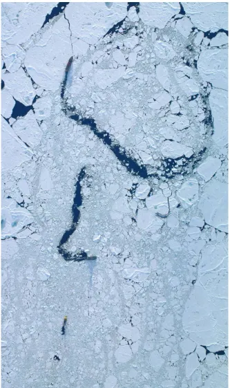
This strategy proved to be successful. Planners had predicted that the fleet could maintain the drillship’s station for up to 2 full days, yet the stationkeeping ability achieved went far beyond this expectation. The three ships coordinated their efforts through a central Fleet Manager, at times on a minute-to-minute basis. The fleet kept the Vidar Viking on loca-tion in 9/10, multiyear ice for up to 9 days—a land-mark feat that has empowered scientists to continue to explore this least known of our oceans through scientific ocean drilling for many years to come. The Sovetskiy Soyuz conducted the first attack on on-coming heavy floes, whereas Oden was the last
de-fense in protecting the drilling operation against the oncoming ice (Fig. F4). During these defensive oper-ations, the officers on the Vidar Viking kept station by manually driving the powerful thrusters with the bow maneuvered to head into the direction of the oncoming ice. The ice management defense strate-gies were continuously updated with information from a full-time ice and weather forecast team on-board the Oden and the Sovetskiy Soyuz.
Coring operations were conducted by Seacore, Ltd., using a specially built drill rig for the Vidar Viking. Coring tools were provided by the British Geological Survey (BGS). Cores were collected on the Vidar Vi-king from five boreholes drilled to a maximum depth of 428 meters below seafloor (mbsf). A single wire-line geophysical log was collected in one borehole. The cores, collected in plastic liners, were sealed for postexpedition analyses onshore at the Integrated Ocean Drilling Program (IODP) repository in Bre-men, Germany. In BreBre-men, the full suite of standard IODP processing methods was completed. Before they were stored, cores were analyzed for physical properties using a Geotek nondestructive multi-sensor core logger (MSCL) (see “Petrophysics” in the “Methods” chapter). Selected intervals were sampled to extract pore water and microbiology samples. During the expedition, core catcher samples were routinely transferred to the Oden twice a day for analyses that included micropaleontology, stratig-raphy, petrophysics, chemistry, and sedimentology.
Synthesis
Site overview
Cores were recovered in five holes across three sites (Holes M0002A, M0003A, M0004A, M0004B, and M0004C) (Tables T1,T2,T3), with a total recovery of 68.4% (Fig. F5). The first hole at Site M0001 was abandoned because a bottom-hole assembly (BHA) was lost (see “Site operations” in the “Sites M0001– M0004” chapter). Logging was attempted in two holes and data were collected over a 153 m open-hole interval in Hole M0004B.
am-Proc. IODP | Volume 302 4
Expedition 302 Scientists Expedition 302 summary
monia concentrations and alkalinity. In terms of re-covered stratigraphy, the bulk of material was pro-vided by Hole M0002A for the upper half of the 428 m long stratigraphic record and Hole M0004A for the lower half, with correlation made possible by a short overlap between the two holes. The other holes re-covered multiple portions of the upper 20 mbsf and allowed construction of a composite depth scale and spliced record for this short interval.
Scientific assessment outcomes
The overall goal of Expedition 302 was to study Arc-tic paleoceanography in order to understand this re-gion’s past climate and its impact on Earth’s climate during the Cenozoic, with particular emphasis on the change from the “greenhouse” world of the Eocene to the “icehouse” world of today.
The primary method was to apply a well-known and effective technique for complete core recovery: con-tinuous piston core and extended core barrel sam-pling in multiple holes at one site. This technique re-sults in a continuous stratigraphic record. This method was not applied during Expedition 302, as no sites were multiple cored (Table T1; Fig. F5). In addition, single-hole penetrations suffered from rela-tively low recovery. The average core recovery for all holes was 68.4%; below 270 m (~47 Ma) to total depth at 428 mbsf, the recovery dropped to 43.1%. Unfortunately, low core recovery plagued recovery of two important Expedition 302 events: the Azolla and the Paleocene/Eocene Thermal Maximum (PETM), resulting in incomplete records for both.
The early results of Expedition 302 show that further analyses of the sediment and basement cores will contribute to five of the seven major paleoceano-graphic objectives and both of the tectonic objec-tives. The degree to which advances are made de-pends on the level of detail that can be extracted from the sediment record.
Generally, the lithologies anticipated in the proposal to IODP were encountered. The overall age span of the sediment section recovered was longer than pre-dicted by a few million years. A major hiatus occurs in the section that spans the transition from the Neogene to the Paleogene. The hiatus means that paleoceanographic analyses over this missing inter-val cannot occur, but interpretation of the overall time and causal mechanisms will contribute signifi-cantly to furthering our understanding of the tec-tonic evolution and resulting depositional environ-ment. The longer time interval will allow us to interpret the paleoclimate conditions during the PETM at an important geographic position for cli-mate studies close to the North Pole.
Among the seven specific paleoceanographic objec-tives, scientific results from Expedition 302 will be used to determine the history of ice rafting and sea ice; study local (e.g., Svalbard) versus regional ice sheet development; reconstruct the density structure of surface waters, the nature of the North Atlantic conveyor, and the onset of northern hemisphere gla-ciation; make contributions to the investigation of the development of the Fram Strait and deepwater exchange between the Arctic Ocean and the World Ocean; and determine the history of biogenic sedi-mentation. The lack of a carbonate stratigraphic record precludes study of the timing and conse-quences of the opening of the Bering Strait. Biogenic carbonate is present only rarely and occasionally in the upper 19 m of the sediment column. The disap-pearance of carbonate occurs together with a de-crease in pH and alkalinity, suggesting that the lack of cocolithophorids, calcareous foraminifers, and os-tracodes in deeper sediments is caused by dissolu-tion.
Expedition 302 results partially address the two tec-tonic objectives. The regional unconformity was penetrated but not well sampled except for a small bag sample. Fossils from this sample constrain tim-ing of the initiation of rifttim-ing to between 80 Ma and the oldest age of the sediment overlying the uncon-formity at 58 Ma.
Early results also reveal that the upper sediments hold a record of sea-ice distribution in the Arctic Ocean well into the middle Miocene. The situation is different in older, underlying cores where dark, or-ganic-rich sediments contain abundant diatoms, ebridians, silicoflagellates, and dinoflagellate cysts, indicating a middle Eocene age and an environment partly characterized by ice-free, warmer surface ocean waters.
Abundant megaspores of the hydropterid fern Azolla
Lithostratigraphy
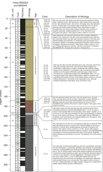
The lithostratigraphy of the Lomonosov Ridge sites is described in terms of four units (Fig. F6). Recov-ered sediments, ranging in age from Holocene to Late Cretaceous (0–428 mbsf), are dominated by lithogenic material. With the exception of sandy lenses, the dominant siliciclastic component of all lithologic units is fine grained, ranging from clays to silty muds. Thin millimeter- to centimeter-thick lay-ers of sand are present down to ~198 mbsf. The up-per ~220 mbsf comprises soft to hard silty clay with colors varying from light brown to olive-green to gray (Unit 1). Isolated pebbles are present through-out Unit 1, with the deepest pebble observed in Unit 2 (239.34 mbsf). This may indicate the presence of at least seasonal sea ice as early as the middle Eocene. A major hiatus occurs at the boundary of Subunits 1/5 and 1/6 at 198.13 mbsf.
Below ~220 mbsf, the sediments change from biosili-ceous silty clay to biosilibiosili-ceous ooze encompassing an interval of ~93 m (Unit 2). The biosiliceous sedi-ments overlie an interval of hard silty clay to mud-stone (Unit 3), which, at ~410 mbsf, rests uncon-formably on Campanian marine sands, sandstone, and mudstone (Unit 4). Results from geochemistry demonstrate that the top of Unit 3 (313–350 meters composite depth [mcd]) holds abundant authigenic silica altered from biogenic opal.
Micropaleontology
Prior to Expedition 302, information about microfos-sil content in central Arctic Ocean cores was limited to observations made in short piston and gravity cores. These cores held records of variable and dis-continuous abundances of calcareous nannofossils, planktonic and benthic foraminifers, ostracodes, and dinoflagellate cysts (e.g., Aksu et al., 1988; Scott et al., 1989; Gard, 1993; Cronin et al., 1994; Ishman et al., 1996; Matthiessen et al., 2001). A single core from the Alpha Ridge contained middle Eocene dia-toms and silicoflagellates (Bukry, 1984; Ling, 1985). Before Expedition 302, no accurate knowledge ex-isted about which biostratigraphically useful micro-fossil groups would be encountered at depth. There-fore, expertise representing all possible microfossil groups were invited as science party members. Expe-dition 302 samples were also systematically analyzed for fish debris.
One of the most striking results is that biogenic car-bonate is almost completely missing from the sedi-ment with the exception of only the upper few meters. Dinoflagellate cysts provide the bulk of avail-able biostratigraphic information.
A 23 m thick interval below ~170 mbsf appears to be nearly devoid of microfossils. This interval is
inter-preted to be of middle Miocene age, based on mag-netobiostratigraphy. Dinoflagellate cysts, diatoms, ebridians, and silicoflagellates are common to abun-dant in the middle Eocene section, which ends in an interval with megaspores of the freshwater hydrop-terid fern Azolla at the lower/middle Eocene bound-ary (~306 m). Biosilica is not present prior to the late early Eocene (~320 m).
The (sub)tropical dinoflagellate species A. augustum
occurs abundantly at ~380 m, indicating that the Paleocene/Eocene boundary and the associated car-bon isotope excursion interval was at least partly re-covered.
Benthic foraminifers indicate that the lower Eocene through upper Paleocene sediments were deposited in shallow-marine, neritic environments.
Sedimentation rates
Biostratigraphy and magnetostratigraphy were used to construct the age model. Among the biostratigra-phy, dinocysts provide the bulk of the Neogene bio-stratigraphic data. In the Eocene, diatoms and silico-flagellates were added to the dinocyst data set. The general structure of the biostratigraphic age-depth point distribution shows two distinct intervals, both having rates on the order of 1–2 cm/k.y. (10–20 m/ m.y.), namely a Pleistocene to middle Miocene inter-val and a middle Eocene to uppermost Paleocene in-terval.
A major hiatus separates the upper Paleocene from the underlying Campanian sediments, which pre-sumably marks the boundary between underlying sedimentary bedrock and the overlying sediment drape on the ridge. Another major hiatus occurs at 198 mbsf, where an interval representing a major portion of the lower Miocene, the Oligocene, and the upper Eocene is missing.
Petrophysics
Petrophysical measurements performed during Expe-dition 302 included downhole wireline logging; nondestructive whole-core measurements of bulk density, compressional P-wave velocity, resistivity, natural gamma radiation, and magnetic susceptibil-ity; and discrete measurements of shear strength, moisture and density, thermal conductivity, and color reflectance.
Downhole wireline logging
Proc. IODP | Volume 302 6
Expedition 302 Scientists Expedition 302 summary
m in-pipe interval was successfully logged, providing in situ measurements of P-wave velocity, resistivity, and natural gamma radiation through lithologic Subunits 1/3 to 1/6.
The caliper logs from the FMS (two per pass) pro-vided a method for assessing the borehole condition. For much of the formation, the hole diameter was under gauge and narrowed significantly between 75 and 90 mbsf, at 155 mbsf, and again between 180 and 184 mbsf. The caliper logs indicated that the borehole conditions for the complete logged section were good and free of any washed-out materials.
Multisensor core logger and discrete physical
property measurements
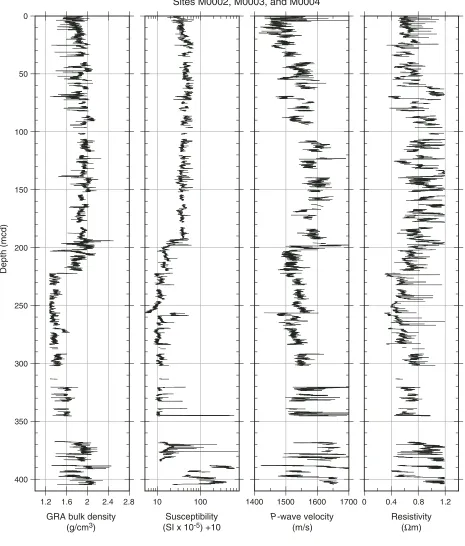
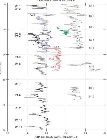
Downhole variations in density, P-wave velocity, and magnetic susceptibility highlight a number of prom-inent stratigraphic changes that exist at all sites and correlate well with observed seismic reflectors. The stratigraphic similarities among the sites allowed a single composite section to be constructed (Fig. F7). Compositionally, the upper 220 m of sediment re-covered from the Lomonosov Ridge is predomi-nantly silty clay (Unit 1). The upper ~20 mcd shows first-order increases in both density and velocity that appear to arise from normal consolidation processes (Fig. F8). Throughout this interval, well-defined deci-meter-scale variations in density, velocity, and sus-ceptibility occur in phase. Below ~20 mcd, a notice-able drop in the shear strength of sediments occurs, remaining low to ~40 mcd, where moisture and den-sity and MSCL measurements indicate an increase in the bulk density of sediments (Fig. F9). Large-ampli-tude variations in bulk density, P-wave velocity, and magnetic susceptibility characterize the bulk of Unit 1 sediments below ~40 mcd.
Between 70 and 100 mbsf, there is a shift away from the high-amplitude variation in magnetic suscepti-bility that is a characteristic feature of the sediments below ~20 mbsf.
A noticeable decrease in all petrophysical properties measured on the MSCL occurs at ~168 mbsf and ac-companies the transition from predominantly olive-green sediments into those characterized by a more yellowish to brown hue at the Subunit 1/3 to 1/4 boundary. One of the most prominent changes is a large decrease in P-wave velocity at ~198 mbsf, mark-ing the transition into Subunit 1/6, which is charac-terized as a silty clay having relatively high TOC and pyrite concentrations. At ~220 mbsf, density de-creases sharply from 1.7 to 1.3 g/cm3 without a
no-ticeable change in the P-wave velocity and is associ-ated with the transition from the pyrite-rich silty clay unit into a biosiliceous ooze (Unit 2).
Large gaps in core recovery occur from ~220 to ~350 mbsf. An increase in density through this interval mirrors changes in the biosiliceous contribution to the matrix material. Below ~370 mbsf, spurious peaks in susceptibility (>5 × 10⁻³ SI) and density (>3
g/cm3) indicate the presence of dense material that is
probably of diagenetic origin. The deepest cores re-covered from Hole M0004A, documenting the tran-sition through sandstone and mudstone and into basement, were too short and disturbed to be run on the MSCL.
In situ temperature measurements
In situ temperature was measured during coring op-erations using the BGS and Adara temperature tools. Postcruise processing is required to determine equili-brated in situ temperatures. The mudline tempera-ture was recorded on all runs and varied between tools. A preliminary attempt to normalize the in situ measurements was made by using the average Adara-determined mudline temperature and adjusting all in situ measurements to this baseline value. The av-erage gradient, using four of the five measurements, is 30.5°C/km.
Chemistry
Shipboard pore water chemistry profiles suggest three geochemical processes: shallow carbonate dis-solution, deep sulfate reduction, and shallow ammo-nium oxidation (Fig. F10).
Lithologic and micropaleontogical descriptions of sediment note a general absence of primary carbon-ate below ~16 mbsf, where pH and alkalinity drop below 7.4 and 2.5 mM, respectively. Assuming con-stant dissolved Ca2+, this means that pore waters near
this depth are more corrosive to carbonate tests than the overlying sediment or water column. Carbonate tests may dissolve when buried in these corrosive pore waters.
The alkalinity inflection at ~200 mbsf suggests chemical reactions are adding substantial amounts of HCO3– at this depth without accompanying H+.
The likely candidate is sulfate reduction of organic carbon:
2CH2O(s) + SO42–(aq) → 2HCO3–(aq) + H2S(aq).
Black sediments (Unit 2) were rapidly deposited be-low 200 mbsf. These sediments host abundant pyrite and lie beneath dark banded intervals that may be composed of other iron sulfide minerals. Organic matter in the black sediment, particularly at ~200 mbsf, dissolved SO42–. This reaction may have
pro-duced abundant H2S in the past and, ultimately, iron
A peak in alkalinity (at ~6 mcd) coincides with a sharp steady rise in NH4+. The peak in alkalinity
sup-ports the interpretation that some chemical reaction is producing HCO3– without accompanying H+. The
NH4+ profile further suggests that upward diffusing
NH4+ drives this reaction.
Microbiology
Sampling for microbiological analyses was con-ducted at fairly regular depth intervals from the sur-face (7 mbsf) to near basement (398 mbsf) with a no-table gap between 169 and 241 mbsf. A total of 21 samples were preserved for enumeration of micro-organisms to provide estimates of subsurface bio-mass. Nineteen samples were stored anaerobically for the purpose of shore-based cultivation studies. A subset of samples (18) was stored at –51°C for deoxy-ribonucleic acid extraction and subsequent micro-bial community characterization. Finally, 10 samples were stored at –51°C for lipid biomarker analysis.
References
Aksu, A.E., Mudie, P.J., Macko, S.A., and de Vernal, A., 1998. Upper Cenozoic history of the Labrador Sea, Baf-fin Bay, and the Arctic Ocean: a paleoclimatic and
pale-oceanographic summary. Paleoceanography, 5:519–538.
Backman, J., Jakobsson, M., Lovlie, R., Polyak, L., and Febo, L.A., 2004. Is the central Arctic Ocean a sediment
starved basin? Quat. Sci. Rev., 23:1435–1454.
Bukry, D., 1981. Silicoflagellate stratigraphy of offshore California and Baja California, Deep Sea Drilling Project
Leg 63. In Yeats, R.S., Haq, B.U., et al., Init. Repts. DSDP,
63: Washington (U.S. Govt. Printing Office), 539–557. Bukry, D., 1984. Paleogene paleoceanography of the Arctic
Ocean is constrained by the middle or late Eocene age of USGS Core Fl-422: evidence from silicoflagellates. Geology, 12:199–201.
Clark, D.L., Whitman, R.R., Morgan, K.A., and Mackay, S.D., 1980. Stratigraphy and glacial marine sediments of
the Amerasian basin, central Arctic Ocean. Spec. Publ.—
Geol. Soc. Am., 181:1–57.
Cronin, T.M., Holtz, T.R., and Whatley, R.P., 1994. Quater-nary paleoceanography of the deep Arctic Ocean based
on quantitative analysis of Ostracoda. Mar. Geol.,
19:305–332. doi:10.1016/0025-3227(94)90188-0
Gard, G., 1993. Late Quaternary coccoliths at the North Pole: evidence of ice-free conditions and rapid
sedimen-tation in the central Arctic Ocean. Geology, 21:227–230.
doi:10.1130/0091-7613(1993)021<0227:LQCATN>2.3.CO;2
Grantz, A., Pease, V.L., Willard, D.A., Phillips, R.L., and Clark, D.L., 2001. Bedrock cores from 89° north: impli-cations for the geologic framework and Neogene pale-oceanography of Lomonosov Ridge and a tie to the
Barents shelf. Geol. Soc. Am. Bull., 113:1272–1281.
doi:10.1130/0016-7606(2001)113<1272:BCFNIF>2.0.CO;2
Heezen, B.C., and Ewing, M., 1961. The Mid-Oceanic Ridge
and its extension through the Arctic Basin. In Raasch,
G. (Ed.), Geology of the Arctic: Torongo (Univ. Toronto
Press), 622–642.
Ishman, S.E., Polyak, L.V., and Poore, R.Z., 1996. Expanded record of Quaternary oceanographic change: Amerasian
Arctic Ocean. Geology, 24:139–142. do i : 10 .11 30/ 0 091
-76 13 (1 996 )024 <0 13 9:ER OQOC> 2.3 .CO; 2
Jakobsson, M., Løvlie, R., Al-Hanbali, H., Arnold, E., Back-man, J., and Mörth, M., 2000. Manganese and color cycles in Arctic Ocean sediments constrain Pleistocene
chronology. Geology, 28:23–26.
doi:10.1130/0091-76 13 (2 000 ) 028< 0023 :MAC CI A>2 . 3.C O ;2
Jakobsson, M., Løvlie, R., Arnold, E., Backman, J., Polyak, L., Knudsen, J.-O., and Musatov, E., 2001. Pleistocene stratigraphy and paleoenvironmental variation from
Lomonosov Ridge sediments, central Arctic Ocean.
Glo-bal Planet. Change, 31:1–22. doi:10.1016/S0921-8181(01)00110-2
Jenkyns, H.C., Forster, A., Schouten, S., and Damsté, J.S.S., 2004. High temperatures in the late Cretaceous Arctic
Ocean. Nature (London, U. K.), 432:888–892.
Jokat, W., Uenzelmann-Neben, G., Kristoffersen, Y., and Rasmussen, T.M., 1992. Lomonosov Ridge—a
double-sided continental margin. Geology, 20:887–890.
doi:10.1130/0091-7613(1992)020<0887:LRADSC>2.3.CO;2
Kristoffersen, Y., 1990. Eurasian Basin. In Grantz, A.,
Johnson, L., and Sweeney, J.F. (Eds.), The Geology of
North America (Vol. L): The Arctic Ocean Region. Geol. Soc. Am., 365–378.
Ling, H.Y., 1985. Early Paleogene silicoflagellates and
ebridians from the Arctic Ocean. Trans. Proc. Palaeontol.
Soc. Jpn, NS, 138:79–93.
Matthiessen, J., Knies, J., Nowaczyk, N.R., and Stein, R., 2001. Late Quaternary dinoflagellate cyst stratigraphy at the Eurasian continental margin, Arctic Ocean: indi-cations for Atlantic water inflow in the past 150,000
years. Global Planet. Change, 31:65–86. doi:10.1016/
S0921-8181(01)00113-8
Scott, D.B., Mudie, P.J., Baki, V., MacKinnon, K.D., and Cole, F.E., 1989. Biostratigraphy and late Cenozoic pale-oceanography of the Arctic Ocean: foraminiferal,
litho-stratigraphic, and isotopic evidence. Geol. Soc. Am. Bull.,
101:260–277.
doi:10.1130/0016-7606(1989)101<0260:BALCPO>2.3.CO;2
Sluijs, A., Schouten, S., Pagani, M., Woltering, M., Brinkhuis, H., Sinninghe Damsté, J.S., Dickens, G.R., Huber, M., Reichart, G.-J., Stein, R., Matthiessen, J., Lou-rens, M., Pedentchouk, N., Backman, J., Moran, K., and the Expedition Scientists, submitted. Subtropical Arctic Ocean temperatures during the Palaeocene-Eocene
Thermal Maximum. Nature (London, U. K.).
Thiede, J., Clark, D.L., and Herman, Y., 1990. Late Meso-zoic and CenoMeso-zoic paleoceanography of the northern
polar oceans. In Grantz, A., Johnson, L., and Sweeney,
J.F. (Eds.), The Geology of North America (Vol. L): The
Proc. IODP | Volume 302 8
Expedition 302 Scientists Expedition 302 summary
Vogt, P.R., Taylor, P.T., Kovacs, L.C., and Johnson, G.L., 1979. Detailed aeromagnetic investigation of the Arctic
basin. J. Geophys. Res., 84:1071–1089.
Wilson, J.T., 1963. Hypothesis of the Earth’s behaviour. Nature (London, U. K.), 198:925–929.
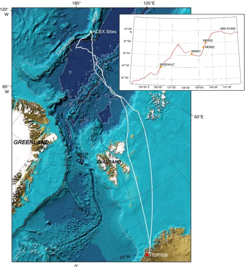
Figure F1. Map of the Arctic Ocean showing the location of the Expedition 302 study area on the Lomonosov Ridge. The insert is a small-scale map showing the locations of Expedition 302 sites.
180° 120°E
120° W
60° W
0°
60°E
AWI-91090
M0003
M0002 M0001
M0004A-C 87°58'
N
87°56'
87°54'
87°52'
87°50'
135°00' E 136°00' 137°00' 138°00' 139°00' 140°00' 141°00'
Tromsø
N
Proc.
I
O
DP
|
V
o
lu
me
302
10
E
x
peditio
n 302
S
cien
tists
E
x
pedition
302
sum
m
[image:10.612.61.700.102.459.2]ary
Figure F2. Seismic reflection profile of the Lomonosov Ridge (AWI-91090) with locations of Expedition 302 coring sites. Multichannel seismic data are from Jokat et al. (1992). Cores were not retrieved from Hole M0001A because the BHA (gray on figure) was lost. Hole M0004B is located ~60 m away from Hole M0004A; Hole M0004C is located ~60 m away from Hole M0004B. SP = shotpoint.
3500 3300 3100 2900 2700 2500 2300 2100 1900 1700
1.0
2.0
3.0
Shots
T
w
o-w
a
y tr
a
v
eltime (s)
SP range of potential sites (~45 km)
M0004A,B,C M0001A M0002A M0003A
Figure F3. Generalized schematic of sea ice transport in the Arctic Ocean. Red contours denote average years of residence time before sea ice export through the Fram Strait. Arrows indicate average transport speeds (pro-vided by Y. Kristoffersen).
1
2
3
4
5
6
BeaufortGyre
Transpolar
Drift
Fram Strait
Proc. IODP | Volume 302 12
[image:12.612.140.473.113.674.2]Expedition 302 Scientists Expedition 302 summary
Figure F4. Photograph taken from one of the Expedition 302 helicopters of stationkeeping operations. The
Figure F5. Core recovery summary diagram for all Expedition 302 holes. Black = recovered core, white = no recovery, and shaded = washed intervals. Total recovery was 68.4%. Hole M0004B was logged.
400 350 300 250 200 150 100 50
0 1H 1X
Proc. IODP | Volume 302 14
[image:14.612.132.484.87.674.2]Expedition 302 Scientists Expedition 302 summary
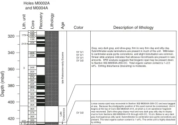
Figure F6. Lithostratigraphic column with age estimates of the Lomonosov Ridge sediments and basement.
This is a compilation from all five boreholes. XRD = X-ray diffraction. (Continued on next page.)
10YR 4/3 10YR 5/4 2.5Y 5/4 5YR 6/4 10YR 4/3 5Y 4/7 5Y 5/4 10YR 4/6 10YR 4/1
Description of lithology
2.5Y 5/4 10Y 4/4 2.5Y 5/4 10Y 4/4 2.5Y 5/4 10Y 4/4 10YR 4/3 10YR 5/4 5Y 5/3 5Y 4/3 5Y 5/1 5Y 5/2 5Y 4/2 5Y 5/6 2.5Y 4/4 2.5Y N4/1 2.5Y N4/0 2.5Y 5/4 10YR 4/3 10YR 3/3 10YR 3/2 2.5Y 7/4 2.5Y N7/10 2.5Y N5/0 5Y 5/2 5Y 3/1 5Y 2.5/1 5Y 3/1 5Y 3/1 Color Depth (mbsf) Lith. unit Core Reco v e ry Lithology Age 20 0 40 60 80 100 120 140 160 180 200 220 240 260 280 300 late Pleistocene middle Miocene-Pleistocene middle Miocene
middle Eocene- middle Miocene mid. Mio . middle Eocene H.-L. Pleist. 1/1 1/2 1/3 1/4 1/5 1/6 2 2X 3X 4X 5X 6X 7X 8X 9X 10X 11X 12X 13X 14X 15X 16X 17X 18X 19X 20X 5X 6X 7X 8X 9X 10X 11X 12X 13X 14X 21X 22X 23X 24X 25X 26X 27X 28X 29X 31X 32X 33X 34X 35X 36X 37X 38X 39X 40X 41X 42X 43X 44X 46X 47X 48X 49X 50X 52X 53X 54X 55X 56X 57X 58X 59X 60X 61X 30X 1X 45X 51X 62X Holes M0002A and M0004A
Silty clay, silty mud, and sandy mud with strong color banding including brown, yellowish brown, light olive-brown, light reddish brown, gray, pale brown, light yellowish brown, dark brown, olive-gray, olive, dark yellowish brown, and dark gray. Color bands range in thickness from 2 to 50 cm, generally with sharp contacts between them. Bioturbation is slight throughout the unit. Smear slide analysis indicates minor amounts of biogenic carbonate. Isolated pebbles (0.5–1.0 cm diameter) occur throughout the subunit. Total organic carbon content is <0.5 wt%. Light olive-brown silty clay with olive-brown thin to medium banding is present in the upper part, and dark brown and yellowish brown silty clay with centimeter-scale, very dark gray mottling is present in the lower part. Isolated pebbles and millimeter- to centimeter-scale sand lenses occur throughout. Slightly to moderately bioturbated throughout. Minor amounts of biogenic carbonate are present. Total organic carbon content is <0.5 wt%. Drilling disturbance is common, with slurry and flow-in in Sections 302-M0002A-3X-1 through 3X-4 and 4X1-1 through 4X-4.
Silty clay and silty mud with alternating olive, gray, olive-gray, olive-brown, dark gray, and light olive-brown color bands at scales ranging from centimeters to decimeters to meters, sometimes with mottled contacts between them. Millimeter- to centimeter-scale sand lenses and isolated pebbles occur throughout. Millimeter-scale dark gray to black micro-concretions are occasionally present from 302-M0002A-29X-2, 141 cm, through the base of the subunit. Bioturbation is slight to moderate with well-defined Chondrites burrows. Total organic carbon content is <0.5 wt%. Drilling disturbance in recovered cores is generally minor, although moderate disturbance (biscuiting), slurry, and flow-in occur.
Silty clay alternates between dark brown, very dark grayish brown, very pale brown, and pale yellow intervals at scales of decimeters to meters. Millimeter- to centimeter-scale sand lenses and isolated pebbles are present throughout. Millimeter-scale dark gray to black microconcretions are common in Core 302-M0002A-39X and below. Bioturbation is slight throughout. Total organic carbon content is <0.2 wt%.
Light gray to gray and olive-gray silty clay with occasional pyrite micro-concretions overlies an interval (302-M0002A-45X-1, 24 cm, to base of subunit 1/5)of variably tilted and crosscutting "zebra-stripe" couplets, 0.5 to 3 cm thick, of very dark gray and black firm silty clay. Bioturbation is slight at the top of the subunit and absent in the zebra-stripe interval. Millimeter- to centimeter-scale sand lenses and isolated pebbles occur throughout. Total organic carbon content is 0.75–1.0 wt%.
Very dark gray, firm to very firm, homogeneous silty clay to clayey silt. XRD data indicate the presence of pyrite and increased feldspar to quartz and kaolinite to chlorite ratios. Isolated pebbles are present throughout this subunit. Total organic carbon content is 2–3 wt%. Smear slide analysis indicates that siliceous microfossils (diatoms, ebridians, and silicoflagellates) are present in minor amounts toward the base of this subunit. Moderate drilling disturbance (biscuiting) is common. The deepest core in this subunit is slurry.
Figure F6 (continued).
5Y 3/1 5Y 4/1 5Y 3/1 5Y 3/2
5Y 3/2
Depth (mbsf)
320
340
360
380
400
420
late P
a
leocene-ear
ly Eocene
Late
Cretaceous
Description of lithology Color
Lith.
unit
Core Reco
v
e
ry
Lithology Age
16X 17X
19X 20X 21X
22X 23X
24X 25X 27X 28X 29X 30X 31X 32X 33X 34X 35X 36X 37X 38X 39X 40X
3
4 42X 15X 18X
26X
41X
Holes M0002A and M0004A
Gray, very dark gray, and olive-gray, firm to very firm clay and silty clay. Submillimeter-scale laminations are present in much of the unit. Millimeter-to centimeter-scale pyrite concretions and slight bioturbation are common. Smear slide analysis indicates that siliceous microfossils are present in rare amounts. XRD analysis suggests that biogenic opal may be present down to Section 302-M0004A-26X-CC. Total organic carbon content is 1–2.5 wt%. Drilling disturbance (biscuiting) is moderate.
[image:15.612.129.486.77.329.2]Proc. IODP | Volume 302 16
[image:16.612.75.540.108.654.2]Expedition 302 Scientists Expedition 302 summary
Figure F7. Multisensor core logger data plotted on a meters composite depth (mcd) scale and spliced together
across all sites. GRA = gamma ray attenuation, NGR = natural gamma radiation. cps = counts per second. (Continued on next page.)
1.2 1.6 2 2.4 2.8
GRA bulk density (g/cm3)
Depth (mcd)
10 100
Susceptibility (SI x 10-5) +10
1400 1500 1600 1700
P-wave velocity (m/s)
0 0.4 0.8 1.2
Resistivity (Ωm) Sites M0002, M0003, and M0004
0
50
100
150
200
250
300
350
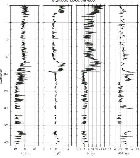
Figure F7 (continued).
20 40 60
L* (%)
Depth (mcd)
-8 -4 0 4 8
a* (%)
-4 0 4 8 12 16 20 24
b* (%)
10 20 30 40 50 60
NGR (cps) Sites M0002, M0003, and M0004
0
50
100
150
200
250
300
350
[image:17.612.72.545.83.618.2]Proc. IODP | Volume 302 18
[image:18.612.97.523.97.655.2]Expedition 302 Scientists Expedition 302 summary
Figure F8. Multisensor core logger data for the upper 20 mcd showing all holes and the overlap achieved
among them. GRA = gamma ray attenuation. (Continued on next page.)
1.2
Sites M0002, M0003, and M0004
GRA bulk density (g/cm3, + 0.2 g/cm3, ...)
Depth (mcd)
4B-1 3A-1
3A-2
4A-1
4A-3 3A-3
4A-2
0
10
20
30
40
50
1.6 2.0 2.4 2.8 3.2
4C-1
4C-2
4C-3
4C-4
4C-5
4C-8
4C-9 4C-6 (split-core)
2A-8 2A-5
2A-7 2A-6
2A-9
2A-11 2A-10 2A-1 2A-2
Figure F8 (continued).
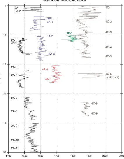
1400 0
10
20
30
40
50
Sites M0002, M0003, and M0004
P-wave velocity (m/s, +100 m/s, ...)
Depth (mcd)
4B-1 3A-1
3A-2
4A-3 2A-1
3A-3
4A-2
4C-8
4C-9 2A-2
1500 1600 1700 1800 1900 2000 2100
2A-8 2A-5
2A-7 2A-6
2A-9
2A-11 2A-10 2A-3 2A-4
4C-1
4C-2
4C-3
4C-4
4C-5
[image:19.612.97.523.85.629.2]Proc. IODP | Volume 302 20
[image:20.612.97.523.91.706.2]Expedition 302 Scientists Expedition 302 summary
Figure F9. Compiled bulk density and shear strength data from offshore and onshore measurements. MSCL =
multisensor core logger, MAD = moisture and density.
1.0 1.5 2.0 2.5 3.0 0
50
100
150
200
250
300
350
400
Bulk density (g/cm3)
Depth (mcd)
0 50 100 150 200
Torvane
Pocket penetrometer
Fall cone
Su (kPa) Subunit 1/2
Subunit 1/3
Subunit 1/4
Subunit 1/6
Unit 2
Unit 3
MSCL
Offshore MAD
Figure F10. Geochemical profiles measured in pore waters extracted from cores during the offshore phase of Expedition 302.
Depth (mcd)
Alkalinity (mM) Squeeze Rhizone
NH4+ (µm)
2.0 2.5 3.0 3.5 0 50 100 150 200
0
10
20
30
Proc. IODP | Volume 302 22
[image:22.612.225.399.79.169.2]Expedition 302 Scientists Expedition 302 summary
[image:22.612.206.419.218.325.2]Table T1. Summary of core recovery.
Table T2. Type and number of cores recovered.
Note: APC = advanced piston corer, XCB = extended core barrel.
Table T3. Washed interval details.
Hole
Length (m) Core recovery (%) Cored Recovered
M0002A 271.69 213.15 78.5 M0003A 15.00 14.85 99.0 M0004A 157.59 78.41 49.8 M0004B 11.00 7.31 66.5 M0004C 40.19 25.34 63.1 Totals: 495.47 339.06 68.4
Hole APC XCB Wash
M0002A 0 62
M0003A 3 0
M0004A 1 41
M0004B 0 2 1
M0004C 4 5
Total number of cores: 8 110 1 Cored length (m): 37.07 455.40 3 Core recovered (m): 36.86 301.2 1 Core recovery (%): 99.4 66.1 33.3
Hole
Depth (mbsf) Washed interval (m) Top Base
M0004A 0.00 17.00 17.00 M0004A 30.50 265.00 234.50 M0004A 330.18 339.00 8.82 M0004A 345.60 355.60 10.00 Total: 270.32
M0004B 0 10 10
[image:22.612.216.409.393.504.2]