Contents lists available atScienceDirect
Land Use Policy
journal homepage:www.elsevier.com/locate/landusepol
Key landscape features in the provision of ecosystem services: Insights for
management
Katja Schmidt
a,⁎, Berta Martín-López
b, Peter M. Phillips
c, Eike Julius
a, Neville Makan
d,
Ariane Walz
aaUniversity of Potsdam, Institute of Earth and Environmental Science, Karl-Liebknecht-Str. 24-25, 14476, Potsdam, Germany
bLeuphana University of Lüneburg, Institute of Ethics and Transdisciplinary Sustainability Research, Universitätsallee 1, 21335, Lüneburg, Germany
cCollingwood Environmental Planning Limited and Department of Civil and Environmental Engineering University of Strathclyde, 75 Montrose Street, Glasgow, G1 1XJ,
Scotland, UK
dScottish Natural Heritage, 231 Corstorphine Road, Edinburgh, EH12 7AT, Scotland, UK
A R T I C L E I N F O
Keywords:
Participatory mapping PPGIS
Landscape features Content analysis Land use management Operationalisation
A B S T R A C T
Whereas ecosystem service research is increasingly being promoted in science and policy, the utilisation of ecosystem services knowledge remains largely underexplored for regional ecosystem management. To overcome the mere generation of knowledge and contribute to decision-making, scientists are facing the challenge of articulating specific implications of the ecosystem service approach for practical land use management. In this contribution, we compare the results of participatory mapping of ecosystem services with the existing man-agement plan for the Pentland Hills Regional Park (Scotland, UK) to inform its future manman-agement plan. By conducting participatory mapping in a workshop with key stakeholders (n = 20), we identify hotspots of eco-system services and the landscape features underpinning such hotspots. We then analyse to what extent these landscape features are the focus of the current management plan. We found a clear mismatch between the key landscape features underpinning the provision of ecosystem services and the management strategy suggested. Ourfindings allow for a better understanding of the required focus of future land use management to account for ecosystem services.
1. Introduction
The concept of ecosystem services is thought to protect nature by contributing to more informed decision-making in land use manage-ment. Although the utilisation of ecosystem services knowledge in de-cision-making is increasingly being promoted by academics and policy makers, its actual uptake in land use management remains largely un-determined (Cowell and Lennon, 2014; Jordan and Russel, 2014; Martinez-Harms et al., 2015). Though there are a few studies that es-tablish a clear link between ecosystem services knowledge and its im-plications for management (e.g. Bryan et al., 2010), a large body of ecosystem services literature provides valuable insights on methods, conceptual issues, and reviews but fails to incorporate concise im-plications for land use management. Consequently, the utilisation of knowledge on ecosystem services in decision-making is found to be “massively under-researched”(Russel et al., 2016).
Recent review papers suggest actions to overcome the mere gen-eration of knowledge of ecosystem services and to effectively contribute
to better environmental management. For instance, several “blind spots” are reported that are currently not sufficiently addressed in ecosystem services research, one of which referred to the relevance and usability of the case study results for the operationalisation of the ecosystem services concept (Lautenbach et al., 2015). Another review on the use of monetary valuation in ecosystem service assessments concluded that researchers often seek to raise awareness rather than effectively contribute to decision-making (Laurans et al., 2013). Simi-larlyMartinez-Harms et al. (2015)identified the need to clarify how knowledge of ecosystem services can be used to support practical management decisions, by means of the clear articulation of objectives, consideration of alternative actions, and inclusion of stakeholder values and preferences by means of deliberative and participatory methods. In one of the few studies about the utilisation of ecosystem services knowledge that adopts an empirical approach, Posner et al. (2016) explore the factors that affect the impact of ecosystem services knowledge on decision-making based on 15 case studies. They found that the legitimacy of knowledge is the most important factor and
https://doi.org/10.1016/j.landusepol.2018.12.022
Received 4 November 2017; Received in revised form 26 February 2018; Accepted 11 December 2018 ⁎Corresponding author.
E-mail address:[email protected](K. Schmidt).
Available online 22 December 2018
0264-8377/ © 2019 The Authors. Published by Elsevier Ltd. This is an open access article under the CC BY-NC-ND license (http://creativecommons.org/licenses/BY-NC-ND/4.0/).
advise that researchers engage meaningfully with decision-makers and stakeholders to incorporate the diversity of views transparently.
Participatory mapping has become a popular approach in ecosystem services research to identify spatial areas of supply and demand of ecosystem services which can be prioritised by land managers for their conservation and restoration (Brown et al., 2012;Wolffet al., 2015). Participatory mapping studies describe processes where individuals take part in the creation of a map (Brown and Fagerholm, 2015). They include public participation geographic information system (PPGIS) studies that use GIS technologies and aim to collect local knowledge and to include and empower marginalised populations (Brown et al., 2012;García-Nieto et al., 2015;Brown and Fagerholm, 2015). Because ecosystem services mapping explicitly relates landscape features (spa-tial indicators) and ecosystem services supply (de Groot et al., 2010), participatory mapping is found a useful method to support decision making in land use management aiming to ensure their future supply by producing spatially explicit results that can be integrated into explicit land use decision criteria (Brown and Fagerholm, 2015). However, little evidence is found that mapped ecosystem services data is being utilised for land use management and few studies contain precise re-commendations to integrate the mapped results into decision making (Brown and Fagerholm, 2015).
In ecosystem services research, recent studies analyze the inter-linkages between landscape features and the supply of ecosystem ser-vices (e.g.Burkhard et al., 2009; Martínez Pastur, 2016;van Zanten et al., 2016;Oteros-Rozas et al., 2017;Tenerelli et al., 2016). Landscape features can be directly linked to the supply of ecosystem services, for instance by a specific land cover, e.g. forest being directly linked to the provision of timber (e.g.Burkhard et al., 2012). Landscape features can be also related with ecosystem services supply through the use of ad-ditional proxies, e.g. recreational services of a landscape are defined by its land cover (e.g. natural area), and also depend on accessibility proxies (e.g. distance to roads;de Groot et al., 2010). Therefore, it is an important challenge for future research to associate these results with current land use management practice in order to utilise ecosystem knowledge and make it applicable for decision-making.
Practices and priorities in land use management are commonly laid out in plans or strategic visions that aim to conserve biodiversity and other natural values (Pressey et al., 2007). As such, conservation plans delineate strategic priorities for land management (Game et al., 2013). These management plans can be strongly targeted to particular fea-tures. To streamline the management of ecosystems towards an eco-system service perspective, it this therefore crucial to associate these landscape features with the supply of ecosystem services. A common method to extract strategic priorities from policy documents is content analysis (Krippendorff, 2012;Neuendorf, 2016). Having its origins in social sciences and humanities, content analysis has recently also been employed in the examination of conservation policy documents (e.g. Leone and Zoppi, 2016;Li et al., 2016;Mascarenhas et al., 2015).
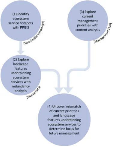
The main aim of this study is to develop an approach that combines approved methods from ecosystem service research to apply the eco-system services concept in practical land use management, and discuss implications for the prioritisation in management planning for a case study in the Pentland Hills Regional Park (Scotland, UK). In doing so, we (1) identify hotspots of cultural, provisioning and regulating eco-system services through participatory mapping, (2) explore landscape features able to provide such ecosystem services hotspots, (3) in-vestigate current land use management priorities, and (4) uncover mismatches to allow for a better understanding of the intended focus of future land use management measures to account for ecosystem ser-vices (Fig. 1). We combine three approaches, i.e. participatory map-ping, spatial analysis of landscape features and ecosystem service supply, and document analysis, to inform land use management in the Pentland Hills Regional Park (Scotland, UK).
2. Study area
The Pentland Hills Regional Park (PHRP) is located to the south-west of Edinburgh (Fig. 3A) and fulfills various functions. Designated under theCountryside (Scotland) Act, 1967 andThe Regional Parks (Scotland) Regulations, 1981, the main objective of the protected area is to promote the integrated management of land for economic (e.g. agriculture, forestry), nature conservation, and recreational objectives (Scott Wilson, 2007a).
Covering an area of approximately 9.200 ha, it comprises a range of different land covers and semi-natural habitats and is predominantly upland in character. The highest point in the Park is Scald Law at 579 m. The upland areas of the park are dominated by grassland (41% of the park area) and dwarf shrub heath (32.5%). Better quality arable land (9%) is present at the peripheral areas at the park boundary. Particularly in the south-west of the park, coniferous woodland is the other major land cover (11.5%). Broadleaved and mixed woodland is found in smaller patches across the park, mostly on lower lying slopes and in the glens that divides the park. Parts of Edinburgh’s water supply are provided by two reservoirs, two other reservoirs provide drought option sources, and there are also a number of private water supplies in the park. The PHRP has been subject to a study on socio-cultural values of its visitors in 2014 (Schmidt et al., 2016a,2017) and a subsequent study on the application of the ecosystem approach to collaborative land use and management (Phillips et al., 2016) funded by Scottish Natural Heritage, the lead public body responsible for advising local and national authorities on all matters relating to the natural heritage. Decisions concerning the practical use and management of land in the regional park are subject to a range of public and private interests. The role of the park management is to offer support and build consensus on shared objectives for the use and management of the park, re-cognising that decisions concerning most land in the park are ultimately within the hands of the landowner/tenant. The City of Edinburgh Council is currently the managing and lead authority of the park and therefore responsible to revise the current management plan which will give a new strategic vision of the park. The management plan’s purpose is to provide the contemporary strategic framework guiding the PHRP management in the formulation of related management action plans (Scott Wilson, 2007a). The current management plan (81 pages) con-sists purely of text and tables that outline management actions, spa-tially explicit considerations for individual areas are not made. Input to issues regarding land use and management planning is provided by the Consultative Forum, a stakeholder group containing a range of interests within the regional park. Ecosystem services are currently not ac-counted for in the management plan.
3. Methods
management of landscape features. The mismatch we uncovered was used to suggest a possible focus for future management.
3.1. Participatory mapping and post-processing of ecosystem services hotspots
We applied PPGIS to identify hotspots of ecosystem services supply during a stakeholder workshop. Participatory mapping of ecosystem services draws on the expertise and local knowledge of stakeholders to explore spatial relationships between landscape characteristics and ecosystem services supply (Brown and Fagerholm, 2015). The work-shop was attended by 20 self-selecting members of the Consultative Forum of the PHRP (Section2). Participants included representatives of local authorities (5 participants), local communities (2), farmers and land owners (5), organised recreational groups (4), a non-governmental organisation (1), and statutory agencies (3).
[image:3.595.110.488.56.548.2]During the mapping exercise, we used large (A0) paper maps of the Pentlands on a 1:18,000 scale to allow participants to identify the lo-cation of different ecosystem services provided by the regional park. Ecosystem services were selected for consideration in the workshop by the project facilitation team, which consisted of an environmental consultancy, Scottish Natural Heritage, and three researchers who have been engaged in ecosystem services research in the Pentland Hills since 2013. The list of ecosystem services was informed by results from the previous study on visitors’socio-cultural values of ecosystem services (in agreement with the regional park management, seeSchmidt et al., 2016a,2017). Participants used sticky dots and drawing directly on the maps to indicate the places where ecosystem services are supplied and draw directly on the maps (Fig. 2). The maps included some existing information about the physical characteristics of the park as prompts for this exercise:
•
cultural ecosystem service map: formal paths, listed buildings, areas that might be considered‘wild’, gardens and designed landscapes, scheduled monuments, conservation areas, country parks;•
provisioning ecosystem service map: burns, arable land, pasture,new woodland plantings (2007–2013), windfarm application;
•
regulating ecosystem service map: burns, riparian woodland,woodland on steep slopes, carbon rich soil/deep peat.
At the beginning of the workshop, participants were introduced to the concept of ecosystem services which were referred to as “natural environment benefits”.
Participants were divided into three groups of 6 or 7 stakeholders, each with representatives of (almost) every stakeholder group. Each group was asked to map ecosystem services out of an assigned eco-system service category (Table 1). In the regulating service category, we had initially also asked participants to map the service“erosion con-trol”. As suspected during the discussion in regulating services group
and confirmed by the spatial location of the data points, participants conflated“erosion control”with the occurrence of erosion. Therefore, we did not include“erosion control”in the analysis as it actually re-presents the“erosion”pressure.
[image:4.595.72.529.56.512.2]hotspots as those areas in the regional park where the workshop par-ticipants identified multiple ecosystem services and that therefore have a relative higher concentration of services. We differentiate between hotspots for cultural, provisioning and regulating ecosystem services.
3.2. Redundancy analysis to identify landscape features underpinning ecosystem services hotspots
We performed redundancy analysis (RDA) to examine the re-lationships between ecosystem services hotspots (dependent variables)
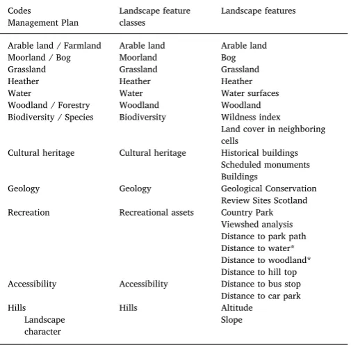
and landscape features (explanatory variables) in the PHRP. RDA has been suggested as an adequate quantitative method to examine whether the overall ecosystem service supply can be explained by a set of en-vironmental factors (Mouchet et al., 2014). RDA visualises ordinations of response variables constrained by explanatory (e.g. environmental) variables (Legendre et al., 2011). First, it performs multivariate re-gressions of a response matrix on an explanatory matrix and so pro-duces a matrix offitted values. Second, it performs a principal com-ponent analysis of this matrix with fitted values. This principal components analysis produces the canonical eigenvalues and eigen-vectors, and canonical axes which are used for the ordination diagrams. To explain hotspots of ecosystem service supply (i.e. response variables), landscape features were derived from spatial data (i.e. ex-planatory variables). We prepared a regular vector grid with 9180 cells and a cell size of 100 x 100 m to cover the regional park. All landscape features were extracted for each cell of the vector grid using various analytical GIS indicators (seeTable 2for an overview of dependent and explanatory variables). The landscape features and additional proxies were grouped into landscape feature classes (Table 3) which relate di-rectly to the management priorities in the current management plan (see Section3.3).
[image:5.595.61.541.54.373.2]Landscape features and proxies were based on land use and land cover data as well as further geoprocessing work (e.g. distance calcu-lations;Table 2). For instance, we mapped accessibility and recrea-tional assets by measuring the distance between car parks, park paths, bus stops, woodland, water, and hilltops and each grid cell with the GIS proximity tool. This way, we recognise particular logistical or landscape features outside of the grid cells that may still have an impact on re-creational use. Additionally we identified if the cells lay within one of the two Country Parks, which are areas with landscape, recreational, and wildlife attributes that are representative of the Pentland Hills but managed exclusively by the local authorities and therefore without Fig. 3.The Pentland Hills Regional Park. (A) Land cover and selected landscape features. The shaded areas indicate elevations. (B) Cultural ecosystem services hotspots, (C) Regulating ecosystem services hotspots. (D) Provisioning ecosystem services hotspots.
Table 1
Ecosystem services mapped at the stakeholder workshop.
Category Definition Benefits discussed at the workshop
Cultural The non-material benefits obtained from ecosystems
Experiencing nature Physically using nature Spiritual and religious benefits
Educational benefits Aesthetic benefits and inspiration Provisioning The products obtained from
ecosystems
Freshwater Food–farmed Food–game and wild collected food Timber and other wood products
Energy–biomass Energy–wind Regulating The benefits obtained from the
regulation of ecosystem processes
[image:5.595.38.290.433.621.2]commercial pressures, for instance, of farmers. We also performed a visibility analysis using viewshed to identify the visual range of each cell. Here we assumed that visibility of the landscape has a large impact on recreational services (see e.g.,Chen et al., 2009). To represent bio-diversity, we used Scottish Natural Heritage’s map of Wild Land Areas to assess the relative wildness of each cell. The data set used four physical attributes to describe wilderness: perceived naturalness, rugged or challenging terrain, remoteness from public mechanised ac-cess, and visible lack of built development and other modern artefacts. Though the Pentlands are not part of a recognised Wild Land Area, the wilderness index is used as a relative measure of wildness in between cells. Additionally, we used a focal neighborhood analysis to assess the number of land cover classes in the surrounding cells as measure of habitat heterogeneity. All editing and analysis of spatial data was conducted using Esri's ArcMap 10, except for the viewshed analysis where QuantumGIS 2.14 was used.
[image:6.595.38.548.76.407.2]We used Moran’s Index (Moran, 1950) to measure spatial auto-correlation of ecosystem services hotspots (specification of hotspots as described in Section 3.1). Because we found positive correlations among all three sets of hotspots (cultural: Moran’s I: 0.22, z-score: 13.7, regulating: Moran’s I: 0.16, z-score: 10.25 provisioning: Moran’s I: 0.20, z-score: 13.1), we continued our analysis with a random selection of 10% of the data points (García-Nieto et al., 2015;Palomo et al., 2014). We selected a balanced subset of the sample in which half of the data points lay within ecosystem services hotspots and the other half outside. Data points within hotspots were selected proportionally to the amount of points (sticky dots) that were originally mapped per ecosystem ser-vice category (cultural: 35%, regulating: 42%, provisioning: 23%). We randomly selected 161 cells with the highest density of cultural ser-vices, 105 cells with the highest density of provisioning serser-vices, and 193 cells with the highest density of regulating services. 469 cells were Table 2
Variables used in redundancy analysis. Explanatory variables marked with * were excluded from thefinal analysis due to a VIF > 5.
GIS indicators Data reference
Ecosystem services hotspots
Cultural Kernel Density analysis Digitised from stakeholder workshop Regulating Kernel Density analysis Digitised from stakeholder workshop Provisioning Kernel Density analysis Digitised from stakeholder workshop
Landcover
Arable land Area in % within cell CEH (2011)
Bog Area in % within cell CEH (2011)
Grassland Area in % within cell CEH (2011) Heather Area in % within cell CEH (2011) Surface water Area in % within cell CEH (2011)
Wood Area in % within cell CEH (2011)
Biodiversity
Land cover diversity Number of LC Classes in neighbour cells (300 x 300 m) CEH (2011)
Wildness Wildness index SNH (2014)
Hills
Altitude Altitude in meter 10 m DTM (EC, 2013)
Slope Slope 10 m DTM/Slope (EC, 2013)
Cultural heritage
Historical buildings Number of historical buildings in cell Historic Environment Scotland (HES, 2011a) Scheduled monuments
(histMonA)
Area in % within cell Historic Environment Scotland (HES, 2011b) Building Building in Cell (yes/no) OS (2017)
Geology
Geological Sites (histGCRa) Area in % within cell SNH (2016)
Recreational assets
Distance to water* Distance to next surface water in meter CEH (2011)Vector Distance to Woodland* Distance to next woodland in meter CEH 2007 LULC Vector Country Park Middle Point in Country park (yes/No) SNH (2011) Distance to paths (DistPaPH) Distance to Pentland Paths
(advertised by PHRP)
Pentland Paths digitised from PH brochure
Distance to hill top (DistHiTo) Distance to next Hilltop All Hilltops over 400 m digitised from 10 m DTM (EC, 2013) Viewshed Viewshed analysis DTM 25 m (EC, 2013)
Accessibility
Distance to car park Distance to next car park Car parks digitised from PH brochure Distance to bus stop Distance to next bus stop Bus stops digitised from PH brochure
Table 3
Relationship between landscape features derived by GIS analysis and codes used in content analysis. Those landscape features marked with * were excluded from thefinal analysis due to a VIF > 5.
Codes
Management Plan
Landscape feature classes
Landscape features
Arable land / Farmland Arable land Arable land Moorland / Bog Moorland Bog Grassland Grassland Grassland Heather Heather Heather Water Water Water surfaces Woodland / Forestry Woodland Woodland Biodiversity / Species Biodiversity Wildness index
Land cover in neighboring cells
Cultural heritage Cultural heritage Historical buildings Scheduled monuments Buildings
Geology Geology Geological Conservation Review Sites Scotland Recreation Recreational assets Country Park
Viewshed analysis Distance to park path Distance to water* Distance to woodland* Distance to hill top Accessibility Accessibility Distance to bus stop
Distance to car park Hills
Landscape character
[image:6.595.38.291.460.708.2]additionally selected outside of ecosystem services hotspots acting as reference points. There is a slight overlap between the highest density cells of the three ecosystem service categories so that the cultural and regulating ecosystem services hotspots share 15 cells, cultural and provisioning share 10, and provisioning and regulating ecosystem ser-vices hotspots share 7 cells. Kernel intensity of each data point was based on the density values (Kernel Analysis output) for each of the cultural, regulating and provisioning ecosystem services hotspots.
To test for linear dependencies among the explanatory variables, we calculated the variance inflation factors (VIF) for each constraint (Belsley, 1991). Whereas a VIF of 1 indicates non-collinearity, a VIF over 10 indicates redundant constraints. In the redundancy analysis, we omit all explanatory variables that have a VIF > 5. We used Monte Carlo permutation tests to assess the significance of the explanatory variables (ter Braak, 1992). Then we calculated the proportion of var-iance that was explained by the axes to assess how well the ordination was representing each hotspot (goodness offit). Tofind the best model of explanatory variables, we used automatic stepwise model building based on permutation tests (Blanchet et al., 2008). We generated a biplot of the variables of the best model RDA to graphically display the patterns of landscape features and how they relate to the ecosystem services hotspots. To avoid heteroscedasticity, we log-transformed both dependent and explanatory variables before carrying out the RDA. All calculations were performed with the statistical software R version 3.3.3 (2017-03-06;R Core Team, 2017). The RDA was performed with the‘rda’function in package‘vegan’(version 2.4-2).
3.3. Content analysis to identify current management priorities
To review current management priorities, we performed quantita-tive content analysis on the current Management Plan (Scott Wilson, 2007a). Content analysis is a widespread, originally qualitative re-search methodology that emerged from the social sciences but has been repeatedly employed in otherfields of study including ecosystem ser-vices research (e.g. Garrido et al., 2017; Richards and Friess, 2015). Content analysis is found a suitable approach to summarise and quan-titatively analyse so-called‘messages’which follows the standards of other scientific criteria (Neuendorf, 2016). After determining the type of content to be examined, the investigators need to typically define variables that are used in their study as well as measures or units of data collection. On this basis, the investigator can develop appropriate coding schemes to finally conduct the content analysis (Neuendorf, 2016).
In this study, we derived a broad list of key categories (‘codes’) for possible management priorities by examining the landscape feature classes able to provide ecosystem services hotspots (Table 3). We dis-regarded possible management aims that were unrelated to any of the landscape feature classes underpinning ecosystem services hotspots, e.g. renewable energy. The management plan was then scrutinised for phrases (‘codings’) that related to these codes, e.g.“recreational pres-sure”as a coding for“recreation”(code),“landscape and the habitat”as a coding for“biodiversity”(code). Subsequently, we added together the amount of codings for each of the codes. This approach was based on the assumption that priorities in land use management would be more frequently addressed than subordinate management objectives. We used MAXQDA Analytics Pro software (MAXQDA, 2017) to facilitate the content analysis.
3.4. Comparison of ecosystem service providing landscape features and current management priorities
We compare RDA scores and content analysis counts by ranking them. By comparing the ranks of landscape feature classes, we un-covered mismatches between the landscape features providing eco-system services and the landscape features included in the current management plan. Because RDA scores for landscape features were
multidimensional, i.e. available on three axes, we ranked them ac-cording to their weighted means based on the proportion of each axis’ contribution to the explained variance (Section4.2). Management plan codes were ranked based on the counts of their respective codings (Section 4.3). The results of the ranking exercise allow for a better understanding of the required focus of future land use management measures to also account for ecosystem services.
4. Results
4.1. Ecosystem services hotspots
The spatial distribution of ecosystem services hotspots as indicated in the participatory mapping differs between ecosystem service cate-gories (Fig. 3B–D). Cultural services such as experiencing nature, phy-sically using nature and educational services are mostly located near water reservoirs in the northwest of the park. The upland areas located in the north of the park and the ridge ranging from the south-east center further south east are important areas for the recreational use of nature but also aesthetic, inspiration and spiritual benefits. Regulating service hotspots were mostly identified in bog areas (i.e. climate regulation, flood regulation) and in and around reservoirs (i.e. flood regulation, water purification) and waterbodies (i.e. water purification). Provi-sioning services were identified in a cluster around the north-west center, i.e. in the reservoirs (providing gamefish and freshwater), in the grassland areas used as grazing and arable land (providing game and wild collected food, biomass for energy production, timber and other wood products), and scattered across the rest of park, i.e. within woodland patches (providing timber and other wood products), in-dividual wind turbines (providing wind energy), along the arable and grazing land of the south-east border of the park (providing farmed food).
4.1.1. Landscape features able to provide ecosystem services
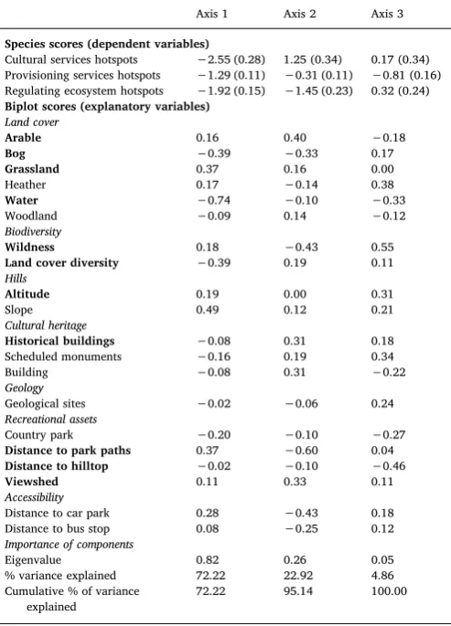
The permutation test indicated a statistically significant association between landscape features and ecosystem service hotspots (p-values: RDA1 0.001, RDA2 0.001, RDA3 0.01 from 999 permutations). VIF diagnostics revealed linear dependencies between distance to water (VIF 11.05) and water as well as distance to woodland (VIF 7.69) and woodland. We therefore omitted distance to water and distance to woodland from the further analysis (seeTable 2).
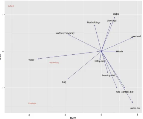
Thefirst two axes explained 95% of the total explained variance (Table 4). Goodness offit diagnostics suggested that cultural ecosystem services hotspots were best explained by the analysed landscape fea-tures, followed by regulating ecosystem services hotspots. Thefirst axis (72% of variance) showed that the presence of water has the strongest implications for all three service categories, followed by the presence of bogs, diversity of land cover, absence of grassland, proximity of park paths, altitude, wildness, absence of arable land and viewshed (Table 4, Fig. 4). The second axis (23% of variance) indicated a trade-offbetween cultural and regulating ecosystem services hotspots. Whereas cultural services hotspots are mostly determined by recreational (historical buildings and viewshed) and accessibility indicators such as the proximity (as opposed to“distance to”) to park paths, car parks, and of bus stops, regulating ecosystem services hotspots are characterised by the absence of these recreational assets, i.e. long distances to park paths, car parks, and bus stops, as well as little viewshed. Regulating services hotspots coincide with bog areas and places that are considered wild, whereas recreational ecosystem services hotspots mostly coincide with the presence of arable land and the absence of wildness and bogs (Table 4,Fig. 4).
hotspots as well (Table 4).
4.2. Content analysis of current management priorities
The content analysis of the current management plan indicated a strong strategic focus on recreational and cultural use of the park, ac-cessibility and biodiversity management (Fig. 5). Most types of land cover (i.e. moorland, water, heather) were mentioned only a few times or have not been referred to once in the management plan (i.e. grass-land).
Codings for recreation included several mentions of recreational pressures as well as recreational activities (Table 5). Biodiversity was referred to as“landscape”,“habitat”, and“environment”, and was ac-counted for by a few examples of habitat and species. Cultural heritage codings included direct mentions as well as accounts of landscape character. Codings for accessibility ranged from“responsible access for all” to public and private transportation modes. Woodland was fre-quently mentioned within the scope of forestry. Arable land / farmland was referred to as the predominant business activity in the Pentlands and described as a significant land use within the park which shapes the landscape. Geology codings included direct mentions as well as a few indirect ones through the account of Regionally Important Geological and Geomorphological Sites (RIGS) groups. Codings for moorland conservation were sometimes conflated with heather management. On a few occasions, they were counted towards“moorland”, despite con-taining references to “heather” (e.g.,”implementation of Moorland Management Plans for core areas of heather cover to ensure that the
resource is maintained and enhanced”). Codings for water include water based recreation, integrated water management, and the man-agement of reservoirs. Hills were acknowledged by their “essential character”.
4.2.1. Comparison of current management priorities and landscape features able to provide ecosystem services
The comparison of results of the RDA with the content analysis of the management plan revealed multiple mismatches (Fig. 6). When ranking landscape features according to their weighted means based on the proportion of all three axes’contributions to the explained variance, we found surface water was the most important landscape feature for the provision of ecosystem services, followed by distance to park paths (as proxy for recreational assets), bog, land cover diversity (as proxy for biodiversity), distance to car parks (as proxy for accessibility), and grassland. Surface water and bog/moorland play a minor role in the current management plan although they are important landscape fea-tures for the provision of regulating, provisioning, and regulating eco-system services. By contrast recreational assets ranked first in the content analysis, although they are mostly important for the provision of cultural ecosystem services. Biodiversity features, which play an important role mostly for cultural and regulating ecosystem services, are also frequently discussed in the current management plan, though there is no explicit mentioning of‘wildness’. Cultural heritage features are associated with cultural ecosystem services in the RDA and are frequently mentioned in the management plan.
5. Discussion
5.1. Methodological approach
This study adopts an innovative approach towards the oper-ationalisation of the ecosystem services approach in land use manage-ment. By integrating complementary and diverse methods and dis-ciplines as well as including multiple actors, we address a few of the current challenges towards real-life application of ecosystem services valuation (Jacobs et al., 2016,2017). Our study illustrates an effective empirical approach to utilise ecosystem services knowledge by com-paring the landscape features underpinning the provision of ecosystem services with the current land use management strategy. For practical use in land use management, it can be easily reduced to a PPGIS mapping exercise which highlights spatially explicit hotspots of eco-system service supply and potential conflicts between ecosystem ser-vices, including areas that need special attention. However, we need to mention several limitations of our mixed methods approach as well as aspects that could be developed further through future research.
First, interactions among sets of ecosystem services, so-called eco-system service bundles, and understanding the mechanisms behind their grouping can be used to adapt management requirements in a way that they avoid trade-offs and create synergies instead of simply re-sponding to existing synergies and trade-offs (Bennett et al., 2009). In our study, we chose a simple PPGIS approach to assess and map eco-system services without accounting for their interactions among each other. We reviewed the correlation of ecosystem services by accounting for spatial autocorrelation and selecting a balanced sample for our further analysis. However, future research should elaborate on the landscape mechanisms behind the grouping of ecosystem services in bundles.
[image:8.595.41.288.108.451.2]Second, our PPGIS approach to mapping ecosystem services is based on stakeholder perspectives and understanding of the Pentland Hills landscape and the mechanisms by which landscape features can con-tribute to ecosystem services supply. This is a recognised approach for mapping ecosystem services supply (Brown and Fagerholm, 2015), and essentially relies on the socio-cultural values of diverse, stakeholders. It thus highlights areas of great importance to people in the park. Stake-holders in this study had a high degree of local knowledge based Table 4
Biplot scores for the redundancy analysis variables, related landscape feature classes, and importance of RDA components. Dependent variables show good-ness offit scores in parentheses. Explanatory variables with a p-value < 0.05 after stepwise model building are in bold.
Axis 1 Axis 2 Axis 3
Species scores (dependent variables)
Cultural services hotspots −2.55 (0.28) 1.25 (0.34) 0.17 (0.34) Provisioning services hotspots −1.29 (0.11) −0.31 (0.11) −0.81 (0.16) Regulating ecosystem hotspots −1.92 (0.15) −1.45 (0.23) 0.32 (0.24)
Biplot scores (explanatory variables) Land cover
Arable 0.16 0.40 −0.18
Bog −0.39 −0.33 0.17
Grassland 0.37 0.16 0.00
Heather 0.17 −0.14 0.38
Water −0.74 −0.10 −0.33
Woodland −0.09 0.14 −0.12
Biodiversity
Wildness 0.18 −0.43 0.55
Land cover diversity −0.39 0.19 0.11
Hills
Altitude 0.19 0.00 0.31
Slope 0.49 0.12 0.21
Cultural heritage
Historical buildings −0.08 0.31 0.18 Scheduled monuments −0.16 0.19 0.34 Building −0.08 0.31 −0.22
Geology
Geological sites −0.02 −0.06 0.24
Recreational assets
Country park −0.20 −0.10 −0.27
Distance to park paths 0.37 −0.60 0.04
Distance to hilltop −0.02 −0.10 −0.46
Viewshed 0.11 0.33 0.11
Accessibility
Distance to car park 0.28 −0.43 0.18 Distance to bus stop 0.08 −0.25 0.12
Importance of components
Eigenvalue 0.82 0.26 0.05 % variance explained 72.22 22.92 4.86 Cumulative % of variance
explained
human-environment interactions and personal experience in the park (see Raymond et al., 2010) as they included people from the park management, local farmers and land owners, and diverse user groups (e.g., recreational, conservation volunteers). Participants to the work-shop also included people from the councils and community councils with local knowledge on plans and development planning as well as people from individual sectors with very specific local knowledge, e.g. Scottish water companies. However, our PPGIS approach is premised on stakeholder perceptions only. To present a multidimensional view of ecosystem services, future contributions should seek to combine our approach with biophysical and monetary methods based on empirical assessments of physical flows of ecosystem services, using environ-mental and monetary data (e.g. soil carbon stocks, recreational visitor surveys, agricultural yields).
Third, when we explore the landscape features that underpin eco-system services, it is difficult to link ecosystem services to specific causal factors because there is still a lack of clarity of which variables contribute to the supply of ecosystem services (Andersson et al., 2015; Bennett et al., 2009;Mitchell et al., 2015). In our study, we chose a list of variables for which spatial data was available; however, to explore the effect of further variables on ecosystem services hotspots, such as species diversity, vegetation composition, and erosion risk can provide
more specific information for the park management.
Fourth, the selection of sample cells has an impact on the analysis of landscape features and selection criteria need to be representative and transparent (Brown and Fagerholm, 2015). Instead of selecting all of the mapped ecosystem services by participants of the workshops, we deliberately used the Kernel function to account for the spatial varia-bility of the landscape and not over-interpret the positional accuracy of mapped ecosystem services (Brown and Fagerholm, 2015). To account for spatial autocorrelation, we used only 10% of the possible data points, while maintaining the balance of mapped ecosystem services per ecosystem services category in line with recent research studies ( García-Nieto et al., 2015;Palomo et al., 2014). Additionally, half of our sample cells were positioned outside of ecosystem services hotspots and served as reference points.
[image:9.595.61.540.55.451.2]Fig. 5.Number of counts for each code within the current Pentland Hills management plan (2007–2017).
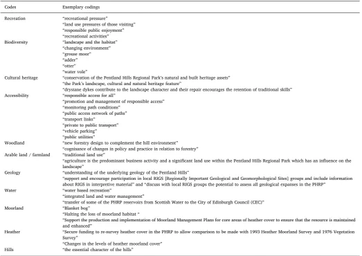
Table 5
Examplary codings from the Pentland Hills regional park management plan.
Codes Exemplary codings Recreation “recreational pressure”
“land use pressures of those visiting” “responsible public enjoyment” “recreational activities”
Biodiversity “landscape and the habitat” “changing environment” “grouse moor” “adder” “otter” “water vole”
Cultural heritage “conservation of the Pentland Hills Regional Park’s natural and built heritage assets” “the Park’s landscape, cultural and natural heritage feature”
“drystane dykes contribute to the landscape character and their repair encourages the retention of traditional skills”
Accessibility “responsible access for all”
“promotion and management of responsible access” “monitoring path conditions”
“public access network of paths” “transport links”
“private to public transport” “vehicle parking” “public utilities”
Woodland “new forestry design to complement the hill environment” “cognisance of changes in policy and practice in relation to forestry”
Arable land / farmland “traditional land use”
“agriculture is the predominant business activity and a significant land use within the Pentland Hills Regional Park which has an influence on the landscape”
Geology “understanding of the underlying geology of the Pentland Hills”
“support and encourage participation in local RIGS [Regionally Important Geological and Geomorphological Sites] groups and include information about RIGS in interpretive material”and“discuss with local RIGS groups the potential to assess all geological expanses in the PHRP”
Water “water based recreation”
“integrated land and water management”
“transfer of some of the PHRP reservoirs from Scottish Water to the City of Edinburgh Council (CEC)”
Moorland “Blanket bog”
“Halting the loss of moorland habitat“
“Support the production and implementation of Moorland Management Plans for core areas of heather cover to ensure that the resource is maintained and enhanced”
Heather “Secure funding to re-survey heather cover in the PHRP to allow comparison to be made with 1993 Heather Moorland Survey and 1976 Vegetation Survey”
“Changes in the levels of heather moorland cover”
[image:10.595.37.561.374.744.2]But slight variations in measurements have little effect in our mixed methods approach that compares generalfindings of the output of two strongly heterogeneous methods, such as quantitative redundancy analysis and qualitative content analysis. If, however, general termi-nological discrepancies arise, e.g. the conflation of farmland and grassland (Section5.2), researchers would be well advised to discuss these with the authors of the document, in our case the PHRP man-agement, and ultimately avoid them. As a related point, it is entirely feasible that management objectives for landscape features other than recreational assets (e.g. land cover, ecologically focused aspects) are held in plans and practices that were not considered in the content analysis (e.g. whole farm plans, commonly accepted practices of farmers and other land managers, relevant regulatory regimes). Future research should aim to take a more comprehensive view of the plans, policies and practices impacting land use management in the Park by including additional material in the content analysis (including inter-views with farmers and other land managers).
Finally, there are several caveats of PPGIS that apply to our case study as well, such as the effect of scale on the mapping results ( Grêt-Regamey et al., 2015) and the number and selection of participants at the workshop (Palomo et al., 2014). Despite these aspects, our study demonstrates how ecosystem services knowledge can be used to guide future land use management towards a better understanding of land-scape features that influence the provision of ecosystem services in the PHRP. The collaborative character of PPGIS between facilitators and participants, for instance, enables a better interpretation of the results. In this study it enabled us to exclude erosion control from the analysis due to false interpretation of this service on behalf of the participants.
5.2. Implications for land use management
In their review of empirical studies that map ecosystem services using PPGIS,Brown and Fagerholm (2015)report that none of the re-viewed articles describe how their mapped ecosystem data could practically be used for land use management. By analysing landscape features that are capable to provide ecosystem services and comparing them to current management priorities, we addressed this research gap and provide recommendations for the revised management plan as outlined below.
In line with previous studies (Burkhard et al., 2009;Martínez Pastur et al., 2016;van Zanten et al., 2016), ourfindings suggest that certain types of land cover are important for the supply of ecosystem services. For instance, cultural ecosystem services have been linked to accessi-bility indicators (Martínez Pastur et al., 2016) and arable land (van Berkel and Verburg, 2014;van Zanten et al., 2016) in previous studies. Grassland is also a significant contributor to cultural services as it has the capacity to provide local identity and recreation (Martínez Pastur et al., 2016) as well as aesthetic value (Lamarque et al., 2011). Our results further underlineBrown’s (2013)findings that water has the greatest social value for ecosystem services and that land cover di-versity is an important contributor to ecosystem services value (van Zanten et al., 2016). However, our results could not confirm the im-portance of woodland for the provision of ecosystem services (Burkhard et al., 2009;Brown, 2013;Martínez Pastur et al., 2016). This could be due to the small size and dispersal of patches in the PHRP that are covered with woodland (Section5.2). The largest connected area cov-ered with woodland, a non-native commercial conifer plantation, is at the very southwest border which is among the least visited of the park (Schmidt et al., 2016b). Consequently, stakeholders did not associate any of the cultural ecosystem services with that particular area. The comparison analysis between the identification of landscape features essential to provide ecosystem services and those landscape features included in the current management plan shows that there are nu-merous associations between current management practices and cul-tural ecosystem services. However, there is a need for land use man-agement to focus on landscape features that are capable of supplying regulating and provisioning ecosystem services in future management planning.
[image:11.595.38.412.60.315.2]riparian areas, access provision, water quality management. In the Pentland Hills, water bodies are partially owned and managed by Scottish Water, a publicly owned company that provides drinking water and disposes of sewage water in Scotland. Given that not all reservoirs lie within the management authority of the regional park, the effect of emphasising the benefit of water bodies in the next management plan may be restricted.
For the supply of cultural ecosystem services, we found recreational, accessibility, and cultural heritage features to be most important fol-lowed by biodiversity, arable land and grassland. Several of these landscape features are already among the priorities of current man-agement planning (i.e. recreational assets, biodiversity, accessibility, and cultural heritage). In our spatial analysis, the important role of arable land for the provision of cultural ecosystem services could be conflated because of the proximity of arable land and the water re-servoirs, which provide various opportunities for experiential and physical interactions with nature. We therefore suggest to further in-vestigate the need to include arable land as a management priority (including possible risks to productive farm land that may arise from increased recreational pressure). Surprisingly, grassland received no mentions in the management plan at all, implying it has no priority despite its relevance for sheep farming activities and giving the Pentland Hills much of its landscape character. This can likely be ex-plained by our selection of codings: We included “farmland” in the same category as“arable land”in our analysis of the management plan, not considering the possibility that farmland may refer to areas where sheep farming takes place, i.e. grassland. Whether an area is used for crop production or for sheep farming can have strong implications for the provision of ecosystem services, e.g. by limiting access to the area, compromising wildlife habitat. Grassland, which is also used for sheep farming in the PHRP, likely fell into the category of“farmland”in the terminology of the management plan, which in our analysis counted towards “arable land”. However, next to cultural, recreational, and accessibility features, cultural ecosystem services hotspots are fre-quently associated with grassland which should therefore be high-lighted in the future management plan.
For the supply of regulating ecosystem services, we found bogs and biodiversity to be most important. Because heather was occasionally mentioned within moorland conservation measures in the management plan, the differentiation of bog and moorland in the document analysis was conflated in a few cases. If there was a clear reference to moorland conservation, we counted the coding toward“moorland”. While hea-ther and moorland measures were sometimes conflated in the man-agement plan, the spatial analysis suggested that bogs are a significant contributor to regulating ecosystem services while heather was found to be generally insignificant for the supply of ecosystem services. Because of this difference for ecosystem service supply, we suggest for the future management strategy to distinguish more clearly between measures for heather and bogs/moorland. Further, we emphasise the importance of moorland for regulating ecosystem services and suggest to make it a priority in the future management plan, e.g. by restricting bog areas to extensive grazing, moorland vegetation management, managing an ef-fective muirburn regime.
Biodiversity and species conservation are currently the second highest priority in the management plan, and landscape features asso-ciated with biodiversity (i.e. wildness, land cover diversity) have also been confirmed highly relevant for ecosystem services supply. These results indicate good synergies between extant conservation measures and ecosystem service supply in the PHRP. The emphasis on biodi-versity is considerably higher in the current management plan than its importance for ecosystem service supply (Fig. 6). Even so, conflicts with biodiversity conservation measures would be very limited in this case study due to the generally low-impact use of the regional park, i.e. restricted development, extensive farming practices, sheep raising, principles for the management of events. Still, our results indicate that a shift towards an ecosystem service focused management can have
implications on the conservation of habitats and biodiversity. Based on our results, we suggest to widen the scope of biodiversity measures and highlight the importance of wild land areas as well as the small-scale diversity of habitats because both make significant contributions to the provision of regulating and cultural ecosystem services. Both bogs and biodiversity are central for the supply of regulating ecosystem services. Including measures for both in the new management strategy could potentially maintain and enhance the supply of regulating ecosystem services.
We found the presence of water and arable land most important for the supply of provisioning ecosystem services. Within the management plan, arable land has been frequently associated with“traditional land use”as well as“the local economy of the hills”. Because the manage-ment plan highlights the economic importance of agriculture for em-ployment and it is one of the central land uses in the PHRP, we suggest to considering measures that enable a balanced use of farming, con-servation, and recreational use to foster a sustainable and multi-functional land use management in the PHRP. Because both water and arable are currently given little priority in the strategic management and because of water’s overall importance for the supply of ecosystem services, we emphasise that suitable measures, particularly for water management, should be identified and included in the revised man-agement plan.
Finally, it is important to consider the drivers behind the production of the current management plan and the types of information and evidence used to inform this, as these factors influence the scope and content of the plan. Management plan development was informed by consultation with the PHRP Consultative Forum (see Section2), meet-ings with specific land managers and the PHRP ranger service, and an initial presentation of the draft plan to the PHRP Joint Committee, a steering group which comprises elected members from the three local authorities intersecting the park as well as several advising members and is responsible for all decisions within the park’s remit. Further, a statutory strategic environmental assessment (SEA) of the draft plan was undertaken in accordance with the Environmental Assessment (Scotland) Act, 2005. This provided a legal basis for wider public consultation on the draft plan along withex-ante assessment of the plan’s potential environmental effects on discrete environmental topics (e.g. species and habitats within the PHRP, water resources / assets, air quality) (Scott Wilson, 2007b). Although not considered explicitly in our study, these process aspects could undoubtedly influence the scope andfinal content of the management plan and therefore its efficacy in terms of landscape management for specific objectives, including pro-tection of biodiversity and enhancement of ecosystem services. Future iterations of the management plan should consider how these process aspects can best be designed to ensure the provision of ecosystem ser-vices. For example, using SEA as a driver for more effective public participation and integration of wider public values with plan-making (Phillips and João, 2017); considering how SEA could be used to assess the impacts of the planex-anteon ecosystems and ecosystem services (Geneletti, 2012;Baker et al., 2013); and further democratisation of land use management planning processes to capture wider public and stakeholder values (Bourgoin and Castella, 2011; Phillips and João, 2017).
interest of reconvening a regular land owner meeting as a forum for raising land owner specific issues. This could be an important me-chanism for delivering practical on the ground action that is largely undertaken on the basis of landowner goodwill. Further, while it can be helpful to use ecosystem service information to guide land use man-agement decision-making (i.e. where the objective is sustaining and enhancing the provision of priority services), empirical evidence from recent studies has shown weak links between ecosystem services pro-vision and key aspects of biodiversity, especially birds (Chan et al., 2006; Morelli et al., 2017;Ziv et al., 2017). This highlights the im-portance of articulating clearly what the objectives are for the future management planning in the Park because a focus on ecosystem service provision will not necessarily result in benefits for biodiversity con-servation. In this study, we suggest to incorporate ecosystem services information into the future management strategy to secure a broader set of desired outcomes. In this context, we recommend to use them alongside biodiversity and recreational conservation measures.
6. Conclusion
In the light of inc reasing calls for the operationalisation of eco-system services, this study provides a practical approach for the utili-sation of ecosystem service research and demonstrates the implications of adopting the ecosystem services concept in land use management. The methodology applied here, systematically reveals the variety of ecosystem services diverse stakeholders benefit from in the regional park, and effectively relates them to current management priorities. The comparison of landscape features underpinning ecosystem services and landscape features currently prioritised by land management in-dicated that the supply of ecosystem services could benefit from an explicit integration of specific landscape features that are crucial for the supply of ecosystem services, e.g. water bodies, bogs, and grassland into the management plan. Our results highlight the benefits of including stakeholders´ perspectives, local knowledge, and participatory mapping for practical land use management planning.
In addition, our study shows that such an ecosystem services cen-tered approach to management planning can reveal the importance of features with high relevance for biodiversity, such as the emphasis on wild areas and habitat diversity in the PHRP. However, it might not be desirable to focus on the supply of ecosystem services under all cir-cumstances, and potential conflicts with conservation or other man-agement objectives need to be well evaluated, in particularly for pro-tected areas. Therefore, to give a credible account of management recommendations, it is crucial to understand management objectives, potential synergies between biodiversity conservation and ecosystem services, and possible social conflicts derived from the management of different ecosystem services.
Acknowledgements
The authors would like to thank Jenny Hargreaves and Chris Alcorn for their support in setting up the stakeholder workshop. In addition we would like to thank all participants of the workshop. The workshop was funded by Scottish Natural Heritage to support the PHRP authorities in developing and adopting a collaborative approach to land use and management in the park. KS and AW werefinancially supported by the European Union’s Seventh Framework Programme under grant agree-ment no. 308393 (‘OPERAs’) and the Horizon 2020 research and in-novation programme under grant agreement No 641762 (‘ECOPOTENTIAL’).
References
Andersson, E., McPhearson, T., Kremer, P., Gomez-Baggethun, E., Haase, D., Tuvendal, M., Wurster, D., 2015. Scale and context dependence of ecosystem service providing units. Ecosyst. Serv. 12 (Suppl. C), 157–164.
Baker, J., Sheate, W.R., Phillips, P.M., Eales, R.P., 2013. Ecosystem services in environ-mental assessment–help or hindrance? Environ. Impact Assess. Rev. 40, 3–13. Belsley, D.A., 1991. Conditioning Diagnostics: Collinearity and Weak Data in Regression.
John Wiley & Sons.
Bennett, E.M., Peterson, G.D., Gordon, L.J., 2009. Understanding relationships among multiple ecosystem services. Ecol. Lett. 12 (12), 1394–1404.
Blanchet, F.G., Legendre, P., Borcard, D., 2008. FORWARD SELECTION OF EXPLANATORY VARIABLES. Ecology 89 (9), 2623–2632.
Bourgoin, J., Castella, J.C., 2011.“PLUPfiction”: landscape simulation for participatory Land use planning in Northern Lao PDR. Mt. Res. Dev. 31 (2), 78–88.
Brown, G., 2013. The relationship between social values for ecosystem services and global land cover: an empirical analysis. Ecosyst. Serv. 5 (Supplement C), 58–68. Brown, G., Fagerholm, N., 2015. Empirical PPGIS/PGIS mapping of ecosystem services: a
review and evaluation. Ecosyst. Serv. 13, 119–133.
Brown, G., Montag, J.M., Lyon, K., 2012. Public participation GIS: a method for identi-fying ecosystem services. Soc. Nat. Resour. 25 (7), 633–651.
Bryan, B.A., Grandgirard, A., Ward, J.R., 2010. Quantifying and exploring strategic re-gional priorities for managing natural capital and ecosystem services given multiple stakeholder perspectives. Ecosystems 13 (4), 539–555.
Burkhard, B., Kroll, F., Müller, F., Windhorst, W., 2009. Landscapes’capacities to provide ecosystem services–a concept for land-cover based assessments. Landscape Online (15), 22.
Burkhard, B., Kroll, F., Nedkov, S., Mueller, F., 2012. Mapping ecosystem service supply, demand and budgets. Ecol. Indic. 21, 17–29.
CEH, 2011. UK Land Cover Map 2007.
Chan, K.M.A., Shaw, M.R., Cameron, D.R., Underwood, E.C., Daily, G.C., 2006. Conservation planning for ecosystem services. PLoS Biol. 4 (11), 2138–2152. Chen, N., Li, H., Wang, L., 2009. A GIS-based approach for mapping direct use value of
ecosystem services at a county scale: management implications. Ecol. Econ. 68 (11), 2768–2776.
Countryside (Scotland) Act, 1967 (online). Available at:http://www.legislation.gov.uk/ ukpga/1967/86(accessed 05/02/18).
Cowell, R., Lennon, M., 2014. The utilisation of environmental knowledge in land-use planning: drawing lessons for an ecosystem services approach. Env. Plann. C: Government Policy 32 (2), 263–282.
de Groot, R.S., Alkemade, R., Braat, L., Hein, L., Willemen, L., 2010. Challenges in in-tegrating the concept of ecosystem services and values in landscape planning, man-agement and decision making. Ecol. Complexity 7 (3), 260–272.
EC, 2013. Digital Elevation Model Over Europe (EU-DEM)- DTM 25m.
Environmental Assessment (Scotland) Act 2005 (online). Available at:http://www. legislation.gov.uk/asp/2005/15/contents(Accessed 5 February18).
Game, E.T., Kareiva, P., Possingham, H.P., 2013. Six Common mistakes in conservation priority setting. Conserv. Biol. 27 (3), 480–485.
García-Nieto, A.P., Quintas-Soriano, C., García-Llorente, M., Palomo, I., Montes, C., Martín-López, B., 2015. Collaborative mapping of ecosystem services: the role of stakeholders׳profiles. Ecosyst. Serv. 13, 141–152.
Garrido, P., Elbakidze, M., Angelstam, P., 2017. Stakeholders’perceptions on ecosystem services in Östergötland’s (Sweden) threatened oak wood-pasture landscapes. Landscape Urban Plann. 158, 96–104.
Geneletti, D., 2012. Integrating Ecosystem Services in Land Use Planning: Concepts and Applications. Centre for International Development Working Paper No.54. Harvard University, Cambridge, Massachusetts.
Grêt-Regamey, A., Weibel, B., Bagstad, K.J., Ferrari, M., Geneletti, D., Klug, H., Schirpke, U., Tappeiner, U., 2015. On the effects of scale for ecosystem services mapping. Plos One 9 (12), e112601.
Hauck, J., Görg, C., Varjopuro, R., Ratamäki, O., Maes, J., Wittmer, H., Jax, K., 2013.
“Maps have an air of authority”: potential benefits and challenges of ecosystem service maps at different levels of decision making. Ecosyst. Serv. 4 (Suppl. C) 25-32.HES, 2011a, Listed Buildings (dataset).
HES, 2011b, Scheduled monuments (dataset).
Jacobs, S., Dendoncker, N., Martín-López, B., Barton, D.N., Gomez-Baggethun, E., Boeraeve, F., McGrath, F.L., Vierikko, K., Geneletti, D., Sevecke, Katharina J., Pipart, N., Primmer, E., Mederly, P., Schmidt, S., Aragão, A., Baral, H., Bark, Rosalind H., Briceno, T., Brogna, D., Cabral, P., De Vreese, R., Liquete, C., Mueller, H., Peh, K.S.H., Phelan, A., Rincón, Alexander R., Rogers, S.H., Turkelboom, F., Van Reeth, W., van Zanten, B.T., Wam, H.K., Washbourne, C.-L., 2016. A new valuation school: in-tegrating diverse values of nature in resource and land use decisions. Ecosyst. Serv. 22 (Part B), 213–220.
Jacobs, S., Martín-López, B., Barton, D.N., Dunford, R., Harrison, P.A., Kelemen, E., Saarikoski, H., Termansen, M., García-Llorente, M., Gómez-Baggethun, E., Kopperoinen, L., Luque, S., Palomo, I., Priess, J.A., Rusch, G.M., Tenerelli, P., Turkelboom, F., Demeyer, R., Hauck, J., Keune, H., Smith, R., 2017. The means de-termine the end–pursuing integrated valuation in practice. Ecosyst. Serv. Johnson, R.B., Onwuegbuzie, A.J., 2004. Mixed methods research: a research paradigm
whose time has come. Educ. Res. 33 (7), 14–26.
Jordan, A., Russel, D., 2014. Embedding the concept of ecosystem services? the utilisation of ecological knowledge in different policy venues. Env. Plann. C: Government Policy 32 (2), 192–207.
Krippendorff, K., 2012. Content Analysis: An Introduction to Its Methodology. Sage. Lamarque, P., Tappeiner, U., Turner, C., Steinbacher, M., Bardgett, R.D., Szukics, U.,
Schermer, M., Lavorel, S., 2011. Stakeholder perceptions of grassland ecosystem services in relation to knowledge on soil fertility and biodiversity. Reg. Environ. Change 11 (4), 791–804.
Lautenbach, S., Mupepele, A.-C., Dormann, C.F., Lee, H., Schmidt, S., Scholte, S.S.K., Seppelt, R., van Teeffelen, A.J.A., Verhagen, W., Volk, M., 2015. Blind spots in ecosystem services research and implementation. bioRxiv.
Legendre, P., Oksanen, J., ter Braak, C.J.F., 2011. Testing the significance of canonical axes in redundancy analysis. Methods Ecol. Evol. 2 (3), 269–277.
Leone, F., Zoppi, C., 2016. Conservation measures and loss of ecosystem services: a study concerning the Sardinian natura 2000 network. Sustainability 8 (10), 1061. Li, R.Q., Woltjer, J., van den Brink, M., Li, Y.F., 2016. How coastal strategic planning
reflects interrelationships between ecosystem services: a four-step method. Mar. Policy 70, 114–127.
Martínez Pastur, G., Peri, P.L., Lencinas, M.V., García-Llorente, M., Martín-López, B., 2016. Spatial patterns of cultural ecosystem services provision in Southern patagonia. Landscape Ecol. 31 (2), 383–399.
Martinez-Harms, M.J., Bryan, B.A., Balvanera, P., Law, E.A., Rhodes, J.R., Possingham, H.P., Wilson, K.A., 2015. Making decisions for managing ecosystem services. Biol. Conserv. 184, 229–238.
Mascarenhas, A., Ramos, T.B., Haase, D., Santos, R., 2015. Ecosystem services in spatial planning and strategic environmental assessment—A European and Portuguese
pro-file. Land Use Policy 48 (Supplement C), 158–169.
MAXQDA, 2017. MAXQDA, Software for Qualitative Data Analysis, 1989-2017. VERBI Software - Consult - Sozialforschung GmbH, Berlin, Germany.
Mitchell, M.G.E., Suarez-Castro, A.F., Martinez-Harms, M., Maron, M., McAlpine, C., Gaston, K.J., Johansen, K., Rhodes, J.R., 2015. Reframing landscape fragmentation’s effects on ecosystem services. Trends Ecol. Evol. 30 (4), 190–198.
Moran, P.A., 1950. Notes on continuous stochastic phenomena. Biometrika 37 (1/2), 17–23.
Morelli, F., Jiguet, F., Sabatier, R., Dross, C., Princé, K., Tryjanowski, P., Tichit, M., 2017. Spatial covariance between ecosystem services and biodiversity pattern at a national scale (France). Ecol. Indic. 82 (Suppl. C), 574–586.
Mouchet, M.A., Lamarque, P., Martin-Lopez, B., Crouzat, E., Gos, P., Byczek, C., Lavorel, S., 2014. An interdisciplinary methodological guide for quantifying associations be-tween ecosystem services. Glob. Environ. Change 28, 298–308.
Neuendorf, K.A., 2016. The Content Analysis Guidebook. Sage. OS, 2017, Ordnance survey (Digimap Licence) (C. C. a. D. Right, ed.).
Oteros-Rozas, E., Martín-López, B., Fagerholm, N., Bieling, C., Plieninger, T., 2017. Using social media photos to explore the relation between cultural ecosystem services and landscape features acrossfive European sites. Ecol. Indic.https://doi.org/10.1016/j. ecolind.2017.02.009.
Palomo, I., Martín-López, B., Zorrilla-Miras, P., García Del Amo, D., Montes, C., 2014. Deliberative mapping of ecosystem services within and around Doñana National Park (SW Spain) in relation to land use change. Reg. Environ. Change 14 (1), 237–251. Phillips, P.M., João, E., 2017. Land use planning and the ecosystem approach: an eva-luation of case study planning frameworks against the Malawi Principles. Land Use Policy 68 (Suppl. C), 460–480.
Phillips, P.M., Orr, P., Mellor, P., 2016. Applying the Ecosystem Approach to Collaborative Land Use and Management in the Pentland Hills Regional Park: Consultative Forum Report. Collingwood Environemental Planning, London. Posner, S.M., McKenzie, E., Ricketts, T.H., 2016. Policy impacts of ecosystem services
knowledge. Proc. Natl. Acad. Sci. 113 (7), 1760–1765.
Pressey, R.L., Cabeza, M., Watts, M.E., Cowling, R.M., Wilson, K.A., 2007. Conservation
planning in a changing world. Trends Ecol. Evol. 22 (11), 583–592.
Raymond, C.M., Fazey, I., Reed, M.S., Stringer, L.C., Robinson, G.M., Evely, A.C., 2010. Integrating local and scientific knowledge for environmental management. J. Environ. Manage. 91 (8), 1766–1777.
R Core Team, 2017. R: A Language and Environment for Statistical Computing. R Foundation for Statistical Computing, Vienna, Austria.
Richards, D.R., Friess, D.A., 2015. A rapid indicator of cultural ecosystem service usage at afine spatial scale: content analysis of social media photographs. Ecol. Indic. 53, 187–195.
Russel, D., Jordan, A., Turnpenny, J., 2016. The use of ecosystem services knowledge in policy-making: drawing lessons and adjusting expectations. Routledge Handbook of Ecosystem Services. Routledge pp. 586-596. ISBN 9781138025080.
Schmidt, K., Walz, A., Jones, I., Metzger, M.J., 2016a. The sociocultural value of upland regions in the vicinity of cities in comparison with urban green spaces. Mt. Res. Dev. 36 (4), 465–474.
Schmidt, K., Müller, C., Walz, A., 2016b. User Survey - Use, Appreciation and Preferences for Future Development in the Pentland Hills Regional Park: Results of User Survey 2014.
Schmidt, K., Walz, A., Martín-López, B., Sachse, R., 2017. Testing socio-cultural valuation methods of ecosystem services to explain land use preferences. Ecosyst. Serv. 26, 270–288.
Scott Wilson, 2007a. Pentland Hills Regional Park Plan (2007–2017). Edinburgh pp. 81 p. Scott Wilson, 2007b. Strategic Environmental Assessment of the Pentland Hills Regional Park Plan–Environmental Report. Available Online. (Accessed 5 February 2018). http://www.gov.scot/Topics/Environment/environmental-assessment/sea/SEAG. Silverman, B.W., 1986. Density Estimation for Statistics and Data Analysis. CRC press. SNH, 2011, Country Parks (Scotland).
SNH, 2014. Scotland’s Wildness Map–Relative Wildness. SNH, 2016. Geological Conservation Review Sites.
Tenerelli, P., Demšar, U., Luque, S., 2016. Crowdsourcing indicators for cultural eco-system services: a geographically weighted approach for mountain landscapes. Ecol. Indic. 64 (Suppl. C), 237–248.
ter Braak, C.J.F., 1992. Permutation Versus Bootstrap Significance Tests in Multiple Regression and Anova. Jöckel, K.-H., Rothe, G., Sendler, W. (Eds.), Bootstrapping and Related Techniques: Proceedings of an International Conference, Held in Trier, FRG, June 4–8, 1990 79–85.
The Regional Parks (Scotland) Regulations, 1981 (online). Available at:http://www. legislation.gov.uk/uksi/1981/1613/contents/made(Accessed 05/02/18). van Berkel, D.B., Verburg, P.H., 2014. Spatial quantification and valuation of cultural
ecosystem services in an agricultural landscape. Ecol. Indic. 37 (Part A), 163–174. van Zanten, B.T., Zasada, I., Koetse, M.J., Ungaro, F., Häfner, K., Verburg, P.H., 2016. A
comparative approach to assess the contribution of landscape features to aesthetic and recreational values in agricultural landscapes. Ecosyst. Serv. 17, 87–98. Wolff, S., Schulp, C.J.E., Verburg, P.H., 2015. Mapping ecosystem services demand: a
review of current research and future perspectives. Ecol. Indic. 55, 159–171. Ziv, G., Hassall, C., Bartkowski, B., Cord, A.F., Kaim, A., Kalamandeen, M.,


![Morphological analysis of the standard Amazigh language using NooJ platform (Analyse Automatique de la Morphologie Nominale Amazighe) [in French]](data:image/gif;base64,R0lGODlhAQABAIAAAP///wAAACH5BAEAAAAALAAAAAABAAEAAAICRAEAOw==)