University of Southern Queensland Faculty of Engineering and Surveying
GPS Usage and Infrastructure Needs for Machine Guidance
and Control in the Construction Projects Associated with
QDMR
A dissertation submitted by
Mr. Nawanandana Chandrasiri Liyanawaduge
In fulfillment of the requirements of Courses ENG4111 and 4112 Research Project
Towards the degree of
Graduate Diploma in Geomatic Studies
Certification
I certify that the ideas, designs and experimental work, results, analysis and Conclusions set out in this dissertation are entirely my own effort, except where otherwise acknowledged.
I further certify the work is original and has not been previously submitted for assessment in any other course or institution, except where specifically stated.
Nawanandana Chandrasiri Liyanawaduge Student Number: 0050020542
--- Signature
ABSTRACT
This dissertation analyzed the GPS usage and infrastructure needs for machine guidance and control, in the construction projects associated with QDMR, in order to provide recommendations for future infrastructure needs. Research studies have confirmed that, GPS usage on machine guidance and control in the construction industry, within a VRS CORS environment increase the productivity of the projects. Investigation about the GPS usage on machine guidance and control, for construction projects, associated with QDMR was selected, as the limit of this study, in order to make recommendations for future infrastructure needs, with respect to a possible VRS expansion.
Three main research approaches were designed in the project, and the results were further investigated. Geographical locations, spread and density, budget allocations and the durations of the projects were analyzed, to find out a clear suite of evidence, to prove the argument. The business case and the associated cost /benefit analysis, confirmed that, it is beneficial to expand VRS coverage to allow QDMR, to use machine guidance and control on construction projects in south east Queensland. Results not only demonstrated that, the VRS expansion is possible in the south east region, but also, suggested that multiple strategies should be adopted, when establishing GPS infrastructure in Queensland, as a whole. VRS expansion is suitable for the locations, with high density of construction projects, while other districts may provide with either, independent GPS networks or should still use, stand alone systems. Recommendations on future GPS infrastructure developments in Queensland based on the above findings and further possible research avenues were also included in this dissertation.
University of Southern Queensland Faculty of Engineering and Surveying
Limitations of Use
The Council of the University of Southern Queensland, its Faculty of Engineering and Surveying, and the staff of the University of Southern Queensland, does not accept any responsibility for the truth, accuracy or completeness of material contained within or associated with dissertation.
Persons using all or any part of this material do so at their own risk, and not at risk of the University of Southern Queensland, its Faculty of Engineering and Surveying or the staff of the University of Southern Queensland.
This dissertation reports an educational exercise and has no purpose or validity beyond this exercise. The sole purpose of the course pair entitled “Research Project” is to contribute to the overall education within the student’s chosen degree program. This document, the associated hardware, software, drawings, and other material set out in the associated appendices should not be used for any other purpose: if they are so used, it is entirely at the risk of the user.
Professor Frank Bullen Dean
Faculty of Engineering and Surveying
ACKNOWLEDGEMENTS
This research was carried out under the principal supervision of Mr. Peter Gibbings, Senior Lecturer, in Engineering and Surveying Department at University of Southern Queensland. I would like to thank the staff at the University of Southern Queensland, in particular Mr. Peter Gibbings for providing the helpful advices.
I also would like to thank the staff at Department of Main Roads, ABC Lasers Ltd, and the Department of Natural Resources and Water. Without the information
regarding the road construction projects, from the Department of Main Roads, and the data provided by the Department of Natural Resources and Water, this project would not have been possible.
TABLE OF CONTENTS
Contents Page
CERTIFICATION………..……….ii
ABSTRACT……….iii
ACKNOWLEDGEMENTS……….v
TABLE OF CONTENTS……….….…..vi
LIST OF FIGURES………...iii
LIST OF TABLES…………..……….………iii
LIST OF APPENDICES……….ix
ABBREVIATIONS………..…….x
CHAPTER 1: INTRODUCTION...1
1.1 OUTLINE OF THE STUDY...1
1.2 RESEARCH AIM AND OBJECTIVES...3
1.3 OUTLINE OF RESEARCH METHOD...3
1.4 JUSTIFICATION...5
1.5 LIMITATIONS OF RESEARCH...5
1.6 CONCLUSIONS: CHAPTER1...6
CHAPTER 2: LITERATURE REVIEW...7
2.1 INTRODUCTION...7
2.2 GNSS GLONASS AND GALILEO SYSTEMS...8
2.3 VIRTUAL REFERENCE STATION CONCEPT...9
2.4 GPS NETWORK SYSTEMS IN THE WORLD ...10
2.5 VRS SYSTEMS IN AUSTRALIA...11
2.5.1 VICTORIA...11
2.5.2 SYDNEY...11
2.5.3 PERTH...12
2.5.4 BRISBANE...13
2.6 MAIN ROADS IN QUEENSLAND (QDMR)...14
2.7 GPS MACHINE GUIDANCE...16
2.7.1 APPLICATIONS OF THE GPS MACHINE GUIDANCE...17
2.7.2 AUSTRALIAN CONTEXT/USAGE OF THE GPS MACHINE GUIDANCE...17
2.7.3 BENIFITS OF GPS MACHINE GUIDANCE...18
2.7.4 ISSUES RELATED TO GPS USAGE ON MACHINE GUIDANCE...18
2.7.5 IMPORTANCE OF USING GPS MACHINE GUIDANCE...19
2.8 GPS INFRASTRUCTURE AND THE PRODUCTIVITY...20
2.8.1 EXISTING GPS INFRASTRUCTURE FOR MACHINE GUIDANCE...21
2.8.2 USAGE OF GPS INFRASTRUCTURE IN OTHER RELATED FIELDS...22
2.8.3 GPS INFRASTRUCTURE DEMANDS...22
CHAPTER 3: RESEARCH DESIGN & METHODOLOGY………24
3.1 INTRDUCTION……….24
3.2 EXPERIMENTAL METHODS……….…….25
3.3 DATA COLLECTION……….……..26
3.4 DATA ANALYSIS……….…28
3.5 CONCLUSION OF CHAPTER 3……….….…30
CHAPTER 4: RESULTS………...31
4.1 INTRODUCTION……….………….………..…….31
4.2 GEOGRAPHICAL LOCATIONS OF QDMR PROJECTS………..…….32
4.3 DENSITY AND THE SPREAD OF QDMR PROJECTS……….33
4.4 LOCATIONS AND THE SUBSIDY ALLOCATIONS………....35
4.5 DURATIONS OF THE QDMR PROJECTS……….…....38
4.6 CASE STUDY – BUSINESS CASE, OPTION B, IPSWICH MOTOR WAY……….38
4.6.1 CASE STUDY – BACKGROUND….……….……….……..39
4.6.2 CASE STUDY – SUMMARY……….………..40
4.7 BUSINESS CASE………..41
4.7.1 COST/BENEFIT ANALYSIS………....41
4.8 CONCLUSION: CHAPTER 4………...…46
CHAPTER 5: DISCUSSION……….47
5.1 INTRODUCTION……….……….47
5.2 DISSCUSSION……….…..47
5.2.1 RESULTS/ INTERPRETATION………....49
5.2.2 ALTERNATIVE SOLUTIONS………...50
5.3 IMPLICATIONS………….……… ………..…...….52
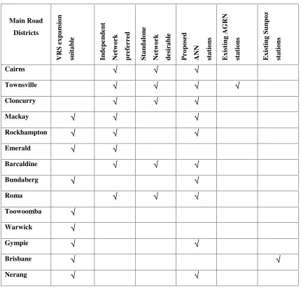
5.3.1 CATEGORIES OF GPS NETWORK DEVELOPMENTS IN QUEENSLAND...…....53
5.4 FURTHER RESEARCH AND RECOMMENDATIONS………...54
5.5 CONCLUSIONS: CHAPTER 5……….56
CHAPTER 6: CONCLUSIONS………57
6.1 INTRODUCTION……….….………57
6.2 CONCLUSIONS……….…57
6.3 POSSIBLE FURTHER RESEARCH………...58
6.4 SUMMARY……….………..…….59
BIBLIOGRAPHY………...60
LIST OF FIGURES
Figure 2.1: Main Road Districts………..………….…………15
Figure 2.2: Visual Indicator at a Grader……….……20
Figure 4.1: Locations of QDMR Projects in Queensland………34
Figure 4.2: State Roads in Each Main Road District……….…...….……37
Figure 4.3: Project Subsidy Allocations………37
Figure 4.4: Comparison of Subsidy Allocations……….…………39
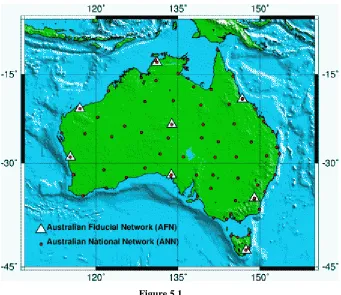
Figure 5.1: Proposed Australian National Network (ANN)……….………52
LIST OF TABLES
Table 4.1: Subsidy Allocations………..36Table 4.2: Construction Costs of a Typical Road Project………...…….…40
LIST OF APPENDICES
ABBREVIATIONS
The following abbreviations have been used throughout the dissertation and appendices.
AFN Australian Fiducial Network
AGRN Australian Regional Reference Network ANN Australian National Network
A$ Australian Dollar
BMA BHP Billiton Mitsubishi Alliance Company CORS Continually Operating Reference Stations DGPS Differential Global Positioning System
DNRW Queensland Department of Natural Resources and Water GIS Geographical Information System
GNS Institute of Geological and Nuclear Sciences in New Zealand GNSS Global Navigation Satellite System
GPS Global Positioning System
MIN/DOT Minnesota Department of Transportation NSW New South Wales
QDMR Queensland Department of Main Roads
QR Queensland Railway
RIP Road Implementation Program RS Reference Station
RTK Real Time Kinematic
USQ University of Southern Queensland VRS Virtual reference Station
2D Two Dimensions
CHAPTER 1
INTRODUCTION
The VRS (Virtual Reference Station) concept from Trimble is an extension of the real-time kinematic (RTK) technique developed for GPS surveying and other forms of high precision positioning.
Higgins & Cislowski (2007)
Regional GPS network of Continuously Operating Reference Stations (CORS) are now being routinely established as the primary infrastructure to support user needs for real-time, centimeter level positioning.
Gordini et al. (2006)
Setting up GPS infrastructure reduces time, labor and the need for a GPS base station (Reference station) for its users making high-accuracy data more viable and affordable.
(Technology & More 2006, p.13)
1.1 Out Line of the Study
Department of Natural Resources and Water (DNRW) in Queensland have established a VRS CORS (Continuously Operating Reference System) network called SunPoz, currently restricted to five stations around the city of Brisbane. Construction projects using GPS machine guidance control, and other surveying applications performed, within this coverage, are benefited by the VRS network
(Higgins & Cislowski 2007).
However, most of the major construction projects, mining activities, and other forms of engineering tasks take place outside the VRS CORS coverage at present. The Queensland Department of Main Roads (QDMR) and the Queensland Railway (QR) are among the government organizations that supervise and undertake the large scale construction projects in Queensland (QDMR 2007).
1.2 Research Aim and Objectives
The aim of this research is to investigate GPS usage on machine guidance and control for construction projects associated with the QDMR in order to make recommendations on future infrastructure needs with respect to a possible VRS expansion.
Is it beneficial to expand VRS coverage to allow Main Roads Department in Queensland to use machine guidance and control on construction projects?
A comprehensive study of the road construction projects, carried out by the QDMR in relation to a possible expansion of the existing VRS coverage may provide answers to the above problem.
1.3 Outline of Research Method
A careful study of the major road construction projects including the locations and durations of the projects undertaken by the QDMR will be carried out. Locations of the projects will depict the limits of the study and further reveal the necessary GPS infrastructure requirements, while durations of the projects will state the importance of long term planning requirements. A case study will be selected in order to calculate the general construction costs associated with the projects. This case study will provide the base to estimate the general construction costs and assist to calculate the cost/benefit analysis. The issues such as uncertain accuracy, precision on machine guidance, latency issues will also be considered in this research study, generally.
project is an investigation of the possible VRS expansion in Queensland, which is directly related to the aim as set out above.
This project is mainly designed to research the information available about the construction projects, associated with the QDMR, within an eight month time frame, in order to achieve the research aim.
The research method is divided into six parts. The first three being the identification and investigation issues relate to GPS usages and infrastructure needs, while the next three sections assesses, the issue in depth and prepare recommendations for possible expansion of the existing VRS CORS network.
The research method is as follows,
1 Research the background information on different types of GPS systems. What they are being used for and where they are being used including, GPS machine guidance instruments for construction projects associated with the QDMR.
2 Identify the current issues with regard to the GPS usages on machine guidance. Issues such as data availability from the existing base stations, different type of GPS usages such as Conventional RTK, VRS RTK and etc, cost of data, latency, accuracy and the reliability of data. The use of VRS RTK as a fast, efficient and effective system of GPS machine guidance.
3 Establish past, present and projected future GPS usage on machine guidance and control in the construction projects associated with the QDMR.
4 Assess the importance of establishing infrastructure for future construction projects in the QDMR, by comparing, the construction projects using GPS networks, against the traditional non GPS usage environments. Extrapolate the QDMR situation to make assumptions on the general construction industry. 5 Prepare recommendations which will be useful for assisting the decision
1.4 Justification
Currently, there are ample satellites in the orbit to choose from, and at least three suppliers of signals. There will be no need to concern about the satellite availability or dilution of precision having potentially 75 satellites available in the orbit all the time (Fairall 2003). GPS machine guidance usage in the construction industry, have been refined by the development of satellite systems and their continuous and constant availability.
GPS machine guidance technology has been used, in the construction projects associated with the QDMR during the past few years, at a low profile. Projects using the GPS machine guidance systems are barely reported or commended in QDMR, comparing to the vast majority of similar successful applications from the private sector companies, appearing in the construction journals.
Establishment of GPS networks around the world, to support the construction projects, indicate that the similar situations can be applied here in Queensland. Research the information about the current GPS machine guidance usage in QDMR, with comparison to a well established GPS infrastructure usage may reveal the recommendations of future needs.
1.5
Limitations of Research
The research is restricted to the information concerning the GPS usage and machine guidance and control use in the construction projects, associated with the QDMR and, its subcontractors. GPS usages by companies or any other parties are only considered generally, in this project when preparing the recommendations for GPS infrastructure as per the following reasons;
(i) Available time does not allow searching the information about construction projects carried out by others.
1.6
Conclusions: Chapter 1
This dissertation aims to investigate, GPS usages on machine guidance and control for construction projects associated with QDMR in order to make recommendations on future infrastructure needs. The research is expected to result in recommendations of future GPS infrastructure developments.
The literature review will provide information of past projects of similar nature and establish the current state of knowledge.
CHAPTER 2
LITERATURE REVIEW
2.1 Introduction
Literature review will reveal the current and past research in the same arena, and the knowledge gained through these projects. Also, the past research projects will enhance, establishing the state of knowledge in the similar context, in relation to further investigations. In addition, literature review is an important part of this research project, because, a fresh attempt need to be a continuation to the past work, rather duplication of the same work. Further, background information is needed, to compare and contrast, the current research progress, with the work which is already been completed, elsewhere.
Therefore, literature review will provide information of past projects of similar nature and establish the current state of knowledge. The aim of literature review is to find the related activities, performed in the past, and the research taking place at present in the similar nature. Also, the critical review of the current problem in a broader perspective will be explained in this chapter.
2.2 GNSS, GLONASS, and Galileo Systems
Use of GPS, GIS, advanced communication systems and other technologies play a vital role in today’s construction industry (Trimble 2007). Carrying out a detail survey in a large construction site with using the GPS instruments is no longer a major task, when comparing to traditional surveying techniques. As a simple navigation tool for finding a road location up to determination of high accuracy points on earth, GPS usage might be the easiest, fastest and the economical method in the modern world, provided that the proper infrastructure have been established.
What are the different types of Global Positioning Systems?
For the past 20 years, the term GNSS (Global Navigation Satellite System) has nearly been synonymous with the US NAVSTAR global positioning system (GPS). GPS was not the only GNSS available. Russia’s GLONASS system was also fully operational during part of this period. Glonass utility remained low as its development generally lacked and adequate number of satellites reliable for general application. Probably, the highest profile development in 2005-2006 was the inauguration of Galileo constellation. The space vehicle sent into the orbit on 28 December 2005 transmitted its first signal on January 12, 2006. The introduction of Galileo constellation, by the European Union, and the planned introduction of regional positioning system by China, India and Japan will create new opportunities for users. Presently, only one system is fully operational. The GPS some Glonass satellites are currently in orbit. The system will reach its full complement by 2010. The first Galileo test satellites are currently in space. Galileo should be fully operational by 2008, as scheduled by the Europeans. The latest incarnation of Japanese QZSS will have three GPS-like satellites in orbit. Sherman et al. (2006)
History of the satellite constellation developments in the past recent years indicate that the GPS usage deliver better results at present as well as in the future.
the GPS constellation developments. This is another positive approach, towards the GPS usage on the machine guidance in the construction industry.
2.3
Virtual Reference Station Concept
The VRS concept from Trimble is an extension of the real time kinematic (RTK) technique developed for GPS surveying and other forms of high precision positioning. With RTK, established reference (base) station at a known point broadcast the data to one or more roving receivers. RTK enables the roving receiver to be positioned with accuracy better than a few centimeters reliable to the reference station. VRS increases productivity by overcoming limitation of the current real-time GPS surveys. VRS has three major advantageous.
1) The use of mobile phone technology overcomes the limitations of the radio link communication.
2) Operators no longer need to set up a base station
3) Multiple reference stations increases confidence in results.
Additional benefits of VRS
There are other inherent advantageous in a VRS system.
• Reliability - If a base station breaks down the operations stop. But with VRS if one station goes down, operations can be carried out with other VRS stations.
• Negate interference factors - A network has more capacity to negate interferences than a single station set up.
• Errors eliminated due to possible simple surveying mistakes. In a traditional surveying system this will carry forward in the subsequent observations.
• Problems of accidental or malicious damage to an unattended base station.
The VRS concept involves permanently running Global Navigation Satellite Systems (GNSS) reference station at spacing up to 70 km. If several construction projects are falling within a 70km radius, all of these projects can be utilized a VRS CORS network instead of setting up individual base stations of their own, which reduces time, labor and the cost.
2.4 GPS Network Systems in the world
New Zealand is already entirely covered by a VRS system of national network of about twenty stations feeding data into one central computer. GeoNet is the first comprehensive nation wide monitoring system in New Zealand. GeoNet has been designed and built by the Institute of Geological and Nuclear Science (GNS) with the bulk of funding coming from the Earth Quake commissions (Thomas 2003).
Minnesota is the 12th largest state in US. Currently, VRS is predominantly being used by MIN/DOT (Department of Transportation). Access to this network is free to everyone. Most of the countries already have the equipment and need only a license, cellular modem, and the VRS software to gain 1-2cm, horizontal accuracy, that has been constantly gained with the new system. In addition, DOT users have used the system to gain good solution at up to 18miles (29km) from the nearest reference station. The new goal is to seed the state with the clusters or pods of four to six VRS stations (Dave, Don & Craig 2003).
2.5 VRS Systems in Australia
To be useful in many new applications, data need to be current in both space and time. The older data is the less useful it is. The new regime depends on a new generation of data creation technologies that centre on the individual in the field.
(Finner 2003).
The following sections briefly explain the existing GPS network augmentation system networks in Australian perspective. This information reveals that establishment of GPS infrastructure is not a new concept for Australians, anymore. What is relevant is the expansion of existing GPS VRS networks to suit the individual circumstances, on state by state basis. Although the current GPS infrastructure networks in all the Australian states are stated here for information, Queensland Sunpoz network is mostly emphasized in this section, as the base of this research study.
2.5.1 Victoria
The Department of sustainability and Environment in Victoria has developed a GPS continually operating reference station infrastructure called GPSnet. Continuously operating reference stations (CORS) has been enthusiastically greeted by the surveying profession. Victoria’s cooperative Global positioning system base station network. The first GPSNet reference to use a combination of Glonass and GPS came into operation in September 2006. Victoria’s Department of sustainability and Environment switched on the station at Robinvale on the River Murray, near Mildura to use the above combination.
2.5.2 Sydney
processing and a Network- RTK service for users in the region. Sydnet is being developed by NSW Department of Lands in partnership with the School of Surveying & SIS at the University of New South Wales. The first Sydnet is only to service basin region, but it is planned for expansion over time to cover other areas in NSW. The Sydnet network may be considered a ‘second generation’ CORS network, as it will be established with net-work based positioning capability from the very start. The physical infrastructure, the communication links and the database are controlled by one agency, the NSW Department of Lands. (Kinlyside & Tan 2005)
2.5.3 Perth
A continuously operating reference station (CORS) network began its operation in 29 th June 2006 in metropolitan Perth. It is the first to be operated by a private enterprise. The network is called GPS Network Perth. It is based on Trimble R5 reference stations. It is the first VRS network to support both GPS L2C and L5 signals and Glonass signals. It provides professional users of GPS equipment around the city with corrected GPS data in real time. It means that, there is now no need to establish a GPS base station in the immediate vicinity of a project. Once, people start using it and experiencing the benefit, it will become the future for GNSS surveying and positioning in the Perth area. The network is likely to be expanded beyond the five reference stations. (Clucas 2005)
While the similar networks operating in Melbourne, Sydney and Brisbane are all managed or administrated by the state government departments this is the only system network established by a privately owned and managed GNSS augmentation Network.
2.5.4. Brisbane
In South East Queensland, Natural Resources and Water (DNRW) has establish a network of continuously operating reference stations (CORS) using the Trimble Virtual Reference (VRS) technology. Sunpoz offers both real-time and post processed products. The real time service has delivered field productivity increases, between 30% to 50% depending on the applications (Higgins & Cislowski 2007). The VRS technology uses CORS and mobile phone to determine real-time centimeter positions. A network of continuously operating reference stations (CORS) was established in the corridor between Brisbane and Gold Coast .The network corrections were decided using the VRS technology.
At present, Victoria’s GPSNet and Sydney’s Sydnet stations use mixture manufacturers' base stations. Brisbane Sunpoz and GPS network Perth both use the proprietary VRS standard from Trimble Navigation.
At present, there are only few reference stations are located in Brisbane in on the roof of DNRW office buildings. DNRW is a decentralized organization with more than 30 offices located across the state. This offers significant benefits in the establishment of a CORS network that is suitable for VRS operations as suggested by the DNRW officials recently.
However, it is debatable that simply selecting these locations as the VRS reference station locations does fulfill the requirement of the national demands. More focus should be drawn towards the use and the users of GPS data rather than an administrative preferences approach.
The existing stations are more benefited by Main Roads and RoadTek and other private companies operating around Brisbane, where the VRS coverage available for their work. It is revealed recently that QASCO has successfully used the Sunpoz CORS network to produce preplanned photogrametric control for the “cut and cover” tunnels called for in the QASCO Bus way Project Plan.
mentioned earlier, major new road projects, precision agriculture and mining industry still has demand on establishing base stations for their work. If Sunpoz CORS network is extended beyond the areas where it operates at present, these organizations will most definitely be benefited.
2.6
Main Roads in Queensland (QDMR)
QDMR is one of the major organizations empowered by the Government legislations to build, Queensland’s major roads which will eventually benefit our future lifestyles. Planning, surveying, designing, constructing and maintaining the new roads for tomorrow, are some of the important tasks undertaken by the QDMR. From planning up to construction stage of new roads, in Main Roads, engineering and surveying involve at various levels.
QDMR plan, design, build and maintain 34,000 km state-controlled road network, highways and other main connecting roads in Queensland (QDMR 2007). It is about 20% of the states total road network and carries about 70% of the state traffic (QDMR 2007). In addition, Main Roads manages National Highways in Queensland on behalf of the federal government. That means, QDMR plans, designs and supervises work on the national highway but the federal government provide funding. The South East Queensland region has responsibility for approximately 2868km of the state controlled roads, including 427km of Auslink national network roads.
At present, QDMR has offices spreading through out Queensland. Figure 2.0 shows the locations of the, fourteen main roads districts in Queensland. There are quite a number of projects, currently supervised by the QDMR and many future projects are expected to be completed within the next five years.
GPS machine guidance usage, on these construction projects in QDMR are presently, at a low profile, possibly, due to non availability of proper infrastructure in the project areas. Current, GPS usage is only restricted to setting up a base station at the site, providing the controls for construction projects. However, the successful VRS developments in Brisbane and other capital cities in Australia by Government organizations and the private sector companies, pave the way to introduce, VRS CORS networks in to other areas where it is needed.
[image:25.595.192.417.361.654.2]
Figure 2.1
2.7
GPS Machine Guidance
The machine guidance or control alternatives may be simply, divided into three categories; 1) 2D guidance needing line of sight, 2) 3D guidance needing line of sight, and 3) GPS guidance systems. There are some important differences between the 3D systems, and that is the fact that, the 3D laser systems need a direct line of sight to the equipment, and the range of operation, depending on the total station used, is usually an area with a radius between 400m to 600m. Therefore, there is a need to move the base station more frequently, than for the GPS system, which covers an area with a radius around 4 km, depending on the radio used.
Another important factor, that should be considered, when selecting a machine guidance system is that, one base station for a GPS system can support an unlimited number of pieces of equipment, while the 3D-laser system needs one base station per machine. This results in a lower cost, for adding a piece of equipment to a GPS system than for the 3D-laser system. The owner and contractor should also note the increased quality of work that can be achieved by using a sophisticated 3D guidance system (Jonasson 2000). Also, the other benefits of a GPS machine guidance system can be listed as, excavate to design, productivity gains, productivity monitoring, and, control
Present developments of the GPS machine guidance technology were erupted about two decades ago. Efforts made during 1980s, to integrate the controls of the construction equipment with the available positioning systems were hindered, due to the expense and the limitations in accuracy. During the 1990s, with the introduction of automatic total stations and global positioning systems, the successful integration of surveying and machine control at construction sites became reality. Early successful automated control systems mostly have been based on 2D laser or ultrasonic technology. Subsequently, robotic total stations have afforded 3D control and most recently, manufacturers of GPS technology have emerged with off-the-shelf systems for machine guidance (Jonasson 2000).
market. Present developments in the GPS machine guidance technology have enabled
the construction companies to achieve a significant increase in their productivity
levels (Leica 2007).
2.7.1
Applications of the GPS machine guidance
The Falkirk Mining Company has been a pioneer in the use of GPS technology, for
machine guidance in land reclamation and mining applications (Leica 2007). The
company has been using Leica’s Dozer 2000 GPS machine guidance system at its
lignite surface mine in North Dakota since 1998, resulting in substantial productivity
improvements and cost savings. Similarly, there are many GPS machine guidance
applications around the world.
2.7.2
Australian context/usage of the GPS machine guidance
In 1999, BMA (BHP Billiton Mitsubishi Alliance Company) approached Leica
Geosystems, to investigate about the Leica 200 Dozer machine guidance package at
their coal mine in Blackwater. For the past 7 years, Blackwater mine has been using
Leica Local counterparts Fleet Management System, a communication network, that
allows mine production to monitor machinery, throughout the whole mine by the use
of GPS receivers. A single order of 15 Leica 200T GPS machine Guidance system to
the Blackwater mine shows that, the importance of using this technology here in
Queensland ( Leica 2007).
The road construction projects associated with the QDMR have been using the GPS
machine guidance for earth work during the past few years. The Burnett River Dam
access road, constructed for Burnett Water Pty Ltd, was one of the projects carried out
2.7.3
Benefits of GPS machine guidance
Benefits of using a GPS machine guidance system can be listed as follows
a) Productivity: - Cost savings
Productivity gains by reducing re-handling of overburden and
subsoil
b) Accuracy: - Near enough is not enough.
Doing accurately for the first time
Excavate to design.
c) Monitoring: - Productivity monitoring
Operator feels more in control
d) Safety: - Provide safety, especially at night when visibility is poor.
The operator needs not to get out of the cab to check the
equipment or stakes.
The productivity gains and the cost savings through the GPS machine guidance
systems are very important aspects, which will be adequately addressed, in this
research project in the following sub chapters.
2.7.4
Issues related to GPS Usage on Machine Guidance
There are few reported setback in the usage of GPS machine guidance technology in
Queensland. The main draw back is that, the unavailability of sufficient GPS coverage,
to provide controls to the construction sites. Establishment of new GPS infrastructure
in Queensland is the alternative way, to overcome this issue.
Despite the facts mentioned above, the other specific issues with regard to GPS usages
on machine guidance are
• Data initialization issues
• Radio, GPRS and mobile link communication issues.
• Data availability from the exiting base stations
• Cost of data - comparison of data available through conventional survey
methods such as Total stations, combination method of GPS+ Total
• Latency issues- Latency is the time it takes to receive the signal from the
satellites, calculate the correction and transmit then to the receiver in the
field.
• Issues such as tree coverage, tree types.
• Trained staff and reliable, hard ware and software.
• Continuous technical support and the effective communication between
them.
2.7.5 Importance of using GPS machine guidance
One of the main importances of GPS technology is that, it is a fast growing
technology. Accurate earth moving equipments have been developed, by the major
equipment manufacturing companies by integrating, GPS, telecommunications, IT and
other technologies. Trimble’s Terramodel is one such total software solution for
integrated survey, design and construction. With the powerful Terramodel, a wide
range of processes can integrate into one operation and improve the construction
workflow. Data can be easily moved between the field and the office and 3D machine
control capabilities in Terramodel reduced setout activities (Trimble 2007).
Latest machine guidance equipments have been designed to use, for a person even
with a little technical knowledge. The major advantage is that the surveyors do not
have to be in the construction sites regularly, setting out the stakes rather engaged
with other important tasks, which requires more technical expertise.
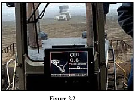
It is a challenging tasks to co-ordinate the many different aspects of road and site
survey, design and constructions. With the advancement of new technologies,
including the use of GPS technology, many hardware and software developers have
developed methods to integrate the activities associated with bulk earthwork and
volume calculations making it easier than ever before. The systems provide a visual
indicator to the grader driver. The following figure 1.1 shows a picture of a typical
The indicator tells the driver, whether the blade is high or low, or to the left or the
right of a line defined by the road design in the software. Also, with the use of GPS
machine guidance and control, it has been far easier for the surveyor at the site, to
carry out their work and volume calculations efficiently. Construction sites falling,
within the coverage of VRS network now has the ability to use VRS data for real time
processing, for grader operators. But the problem is that most of the major projects are
falling outside the VRS CORS coverage and still has the necessity to engage another
GPS controller as a base station which needs extra time, cost and effort.
[image:30.595.205.431.254.422.2]
Figure 2.2
Visual Indicator at a Grader
(Leica 2007).
2.8 GPS Infrastructure and the productivity
With the improvement of the GPS machine guidance systems, and the widespread
GPS usage in Queensland, it is inevitable, finding alternatives to establish GPS
infrastructure in the areas where it is badly needed. GPS machine guidance systems
within the mining industry still operate as stand alone systems, due to unavailability of
suitable GPS infrastructure in most of the parts in Queensland. If established GPS
infrastructure is available, and the access to the net work is affordable, then there will
The existing GPS infrastructure, either cover only a limited area or does not cover any
area at all, in many circumstances. As such, productivity in the construction projects
hinder, and therefore, the cost of each project will increase comparatively.
2.8.1 Existing GPS Infrastructure for machine guidance
The classic RTK methodology allows for an operational distance between the
reference stations (RS) and the user of up to 10-15 kilometers (ICSM,2004), due to
the correlation of some GNSS errors with distance. By adopting a Network RTK
(NRTK) VRS approach, this operational range can be extended to 40-70 kilometers
according to the recommendation of the author of GPSNet [trademark] software
(Trimble 2001).
GPS machine guidance is a real-time application, which needs continuous coverage of
controls. Most viable method is to establish a base station at a close vicinity to the site,
in order to carry out the earth moving operations. Stand alone systems are good
enough to increase the productivity, when there is no coverage of VRS CORS net
work.
Currently, DNRWs Sunpoz is the only network operating in south-east Queensland,
which provides the continuous VRS coverage for its users closer to the Brisbane Area.
Apart from this network, there are two other Australian Regional GPS Network
stations , (ARGN) available in Townville, and Alice Springs, which provide AUSPOS
data for post processing GPS applications.
2.8.2
Usage of GPS Infrastructure in other related fields
Establishment of a GPS VRS Network, merely to sustain the earth work operations, in
users. The evidences provided, support and enhance the importance of immediate GPS
Infrastructure needs, in Queensland. Although, QDMR road construction projects are
only considered here to highlight the productivity, cost savings and the GPS
Infrastructure needs, it is very important to consider about the other major potential
GPS users, as well. Queensland Railway (QR) is one such large organization that
could be benefited from a new VRS Network. Also, the other potential users can be
identified as,
1) Mining companies.
2) Farmers, for precision agriculture, and forestry.
3) Navigation and location based services.
4) Local Government Organizations.
5) Surveyors, and other surveying related groups.
6) Research organizations and Universities.
These prospective users and their expected contribution to the usage of the GPS
Infrastructure will be an enormous outcome to the program, in the long term. On the
other hand, these users and their continuous and increasing demand, will eventually
strengthen, the ultimate requirement of a National GPS VRS network in Queensland.
2.8.3.
GPS Infrastructure demands
Queensland is one of the biggest states in Australia with a large area extents and
widely spaced population distributions. Therefore, it seems that the idea of NRTK
coverage is not economically viable for Queensland. As such, the establishment of
sparse CORS networks over wide areas, in combination with higher density
sub-networks in locations that, fully justify the investment is required. However, the
careful considerations of the data available for road projects in the eastern side of
Queensland may suggest that, there is a possibility to establish a VRS network
2.9
Conclusions/Summary: Chapter 2
Literature review exposed, the current and past research in the same arena, and the
knowledge gained through these projects. As, discussed in length, literature review is
an important part of this research project, because, it enabled, the new work to be
started, as a continuation to the previous work, without duplicating the same work.
Further, background information will be compared, with the results and findings at
chapter 5.
Most of the construction projects, and the mining projects falling outside the VRS
coverage, still need to spend more time, on establishing control at construction stages.
If a new network similar to the existing VRS CORS system or, the current network
can be expanded into the other areas, where it is needed, this will eventually increases
the productivity, and therefore the efficiency in return. Identifying the general issues
mentioned above in the construction industry, as a whole, is a massive task. However,
carrying out a major study to investigate, GPS usage on machine guidance and control
for construction projects, associated with the QDMR would be one of the best
solutions to the above problem.
As, QDMR has already undertaken Road projects across the entire estate, study of
GPS usage and infrastructure needs and control on the construction projects,
associated with the Department, will generate a better understanding of designing an
effective VRS CORS network in Queensland. In addition, this dissertation aims to
make recommendations on future GPS infrastructure needs for the construction
CHAPTER 3
RESEARCH DESIGN AND METHODOLOGY
3.1
Introduction
This chapter describes the research design and methodology, which was used in this
project. Research design provided an overview of the entire project, while
methodology was important as the basic plan, to achieve a successful outcome to the
design, with available resources and within the allocated time. Experimental methods,
data collection and data analysis are the core factors, or the key elements, which have
been explained in this section as part of the research design and methodology.
Therefore, the aim of the research design was to follow an order of research approach
to the issue, in order to obtain a successful outcome. Knowledge gained through the
past researches, and their findings were utilized in the project, to develop an
independent research method, in order to find a solution to the research topic. The
research methodology already mentioned in chapter 1.3, is further explained here, as
experimental methods, data collection, and data analysis.
Literature review in chapter two revealed that, GPS usage on machine guidance and
control, in the construction industry, have been tested successfully, in Australia and
around the world. Furthermore, Study also revealed, more cost savings, and
productivity gains, can be obtained, by using the GPS machine guidance technique, in
the construction industry, within an established VRS CORS Network environment.
This VRS CORS network can be a completely new network, expansion of the existing
network or a series of nodes (independent network) or a clustered network, depending
upon the individual circumstances. Established GPS infrastructure in the world and
other states of Australia indicated that, positive approach and further investigations
can be made to recommend and design the infrastructure needs in Queensland.
Apparently, the above findings suggested that, QDMR construction projects using the
establishment of a new VRS CORS Network. Therefore, this research is mainly
designed, to investigate the GPS usage and infrastructure needs for machine guidance
and control in the construction projects associated with the QDMR.
3.2
Experimental Methods
As this research project was mainly focused, on the construction projects, associated
with the QDMR, collection of detailed information about the present, and future road
construction projects in Queensland, was required, as the foundation for this research.
Detailed information such as the project name, location, budget of the project, road
length, project duration, type of the construction etc; was collected at the initial phase
of the research. Then, this information about the construction projects were grouped,
into their geographical locations, with attribute data, such as estimated cost of the
project, project duration etc; attached.
Collecting this information and sorting out these relevant data, was necessary, so that
it can be easily marked on a relevant map. Marking the project locations
approximately, on several maps in A4 and A3 sizes, was essential, to study the spread
of the construction projects, in each geographical location of the main road districts. It
also helped to identify the areas, where the constructions are planned, in the future.
Plotted maps, was used to find out, the density of the existing projects, and to perform
further data analysis in order to recommend future infrastructure needs.
A case study about a past construction project, was carried out, to find out the general
construction costs, associated costs, and GPS machine guidance costs in a general
construction environment. This information was later used as the approximate
percentage values to calculate the cost/benefit analysis.
A business case was planned, to justify the conception of future possible VRS
expansion, in order to assist QDMR construction projects in Queensland. General
construction costs, earth work costs, instrument costs and other associated costs in a
the existing VRS stations, and the annual fee for the license agreements with DNRW,
were also acquired to calculate the cost/benefit analysis. This information was
obtained from QDMR, DNRW and the equipment sales agents. Cost/Benefit analysis
was prepared to calculate the cost savings, from the total budget allocations in QDMR,
for the next 2 year period, by using the GPS machine guidance systems under an
established VRS CORS network environment. For the calculation purposes only, an
assumption was made, as the VRS expansion, beyond the existing stations have been
established and these infrastructure have been used by QDMR, for the construction
work. Cost/benefit analyses, based on the above results, represented sufficient
evidences, to justify and recommend the GPS Infrastructure expansion in Queensland.
Present a business case to support the argument of establishing a new VRS CORS net
work, expansion of the existing net work or planning a series of Nodes in Queensland,
was the end result or the outcome, which was expected from this research approach.
Preparation of recommendation for future GPS usage and Infrastructure developments
based on the findings is the other major outcome, which will be accomplished in this
research work. These recommendations will be adequately discussed in chapter five,
for the benefit of the authorities and the interested parties, who would contribute, in
the process of establishing future VRS expansion in Queensland. Designing a robust
VRS CORS Network, is another task, which is beyond the scope of this work, to be
continued, based on the recommendations from this research project.
3.3
Data Collection
As most of the information about the present and past major construction projects, are
available through the QDMR website, during the process, it was decided, to collect all
the necessary data, into a separate project directory. Plans, Maps and other relevant
materials were printed, as hard copies, in order to identify and mark the project
locations on the plans, manually. Collection of data was carried out mainly by the
following sources;
a) From the QDMR website in digital form, or as hard copy printouts. These
• Current and proposed construction project details. Collected data is
included under Appendix B, as QDMR Projects and Maps.
• Past project details, Project reports, Feasibility studies, and business
cases for road construction projects.
• Construction projects and the budget allocations, planned under the
RIP program.
• Detailed information such as the area extents, population, state roads,
federal roads, total length of roads, staff and other social and
economical details about each main road districts.
• Map of the main road districts.
• Large scale plans, of each Main Road districts in A4 and A3 sizes.
• Plans showing the main road district headquarters, QDMR road
numbers, names and the local government boundaries.
• Main Roads and RoadTek magazines and Newsletters.
b) Contacting, individuals and relevant authorities or companies by various
means.
Individuals, authorities and the companies were contacted, included:
• Senior Surveyor at DNRW in Brisbane.
• Principal Advisor, Research and development in QDMR.
• Senior Advisor in surveys in QDMR, at Eagle Farm and Nerang.
• Machine Guidance Instrument Specialist from ABC Lasers in Acacia
Ridge.
• Project Managers and Civil Engineers for construction projects in
QDMR in Brisbane.
These parties were contacted either by emails, telephone or organizing the meetings.
Valuable information regarding the existing SunPoz network, were obtained from the
Senior Surveyor at DNRW. Sunpoz VRS network, it’s coverage, current usage, past
projects, major projects carried out in the past by using the Sunpoz network, annual
maintenance costs, license agreements, fees and other relevant topics such as, future
developments were discussed during this conversation. Officers from the QDMR
responsible for managing the road construction projects using the machine guidance
systems.
c) Collecting the information through the relevant websites.
The background information for literature review was collected from various
internet sites, as listed in the references. In addition, several other websites
were visited, to study the past knowledge, relevant to the topic. Mainly,
information regarding the VRS CORS Networks, GPS machine guidance
instruments and their usage, and the GPS infrastructure developments in
Australia and around the world were studied and the relevant data was
collected.
d) From the USQ Library, Books, Magazines and Journals.
USQ library on the internet was visited and the articles relevant to the topic
were extracted. Books, magazines and other technical journals were examined
and the data relevant to the research topic were copied with due recognition, as
listed in the reference page.
3.4
Data Analysis
Data analysis was performed, to determine either stand alone or VRS CORS GPS
Network systems are more suitable, for the areas concerned, in relation to the
following questions.
• Spread of projects, with their geographical locations?
• Potential QDMR use?
• What are the other users?
• Is VRS suitable?
• Should VRS used or use stand alone bases?
• Who is responsible for expansion of the network?
Maps with the locations of QDMR construction projects marked were used to explore,
whether expansion of the existing VRS network is possible or alternative methods are
required. What are the alternatives, whether it is to establish series of nodes or to use
QDMR usage of a possible VRS network. What are the other users? Due to the nature
of different kind of geographical locations, establishment of a VRS network, merely
to support, QDMR projects may not be the best solution. Therefore, the other potential
users such as mining, agriculture and the services and their support and the
contributions were also regarded. Expected durations of the projects was one of the
key points, that considered, when recommending the future GPS infrastructure, since,
ongoing commitment is necessary, to use and maintain these infrastructures.
Obviously, stand alone GPS systems are more suitable, for short term projects, where,
implementation of mass GPS infrastructure is just a waste of time and energy.
Therefore, long term construction projects were highly considered, when analyzing
the data, as these projects strengthen the requirements of future GPS infrastructure
demands.
Collected information about the construction projects, planned under RIP program
was tabulated to various forms of graphical presentations, to explain and highlight the
relevance of these data. These tables, graphs and charts are included and explained in
chapter four, and Appendix C, to discuss the actual data analysis.
Although, the details about the road construction projects, budgets and durations of
the projects are available through the QDMR website, there is no extensive detail,
documented about the earth work or the earth work using the GPS machine guidance
systems, in the construction projects. However, considerable amount of details are still
available in the QDMR website to calculate the percentage of earth work, in a
construction project. Feasibility studies and the cost estimates about the major projects
as well as the project reports, also, provide significant contributions to find the details
of the GPS machine guidance usage in the construction projects, associated with the
QDMR. A report prepared by Project Support, for the Ipswich Motorway Alternative
Northern Corridor, Alternative option, was used as the case study to obtain the costs
for construction costs. These values were used as a guide, to calculate the cost/benefit
analysis.
A business case was prepared with the cost/benefit analysis and the recommendations
were given based on the findings /results from the above data analysis. The actual data
3.5
Conclusions: Chapter 3
Established GPS infrastructure in the world, and other states of Australia indicated
that, further investigations can be made to improve, develop and design the new GPS
infrastructure in Queensland. Knowledge gained through the similar projects in the
past, was utilized in this research, to develop an independent research method, in
order to find a solution to the research topic.
Collection of data, about the current construction projects associated with QDMR
mostly updated, and available through their website. Detailed information also
available from the same website for each project, including the total budget of each
project. However, a case study to find out the construction cost was carried out from a
project report, prepared for QDMR. Establishment of VRS CORS network will be a
challenging task, as it requires considerations to the main question of whether; it is the
ideal network or the best solution. Finally, the recommendations about the GPS usage
and infrastructure will be prepared, with all the knowledge and the information
gathered during the course of the research project and included in the preceding
CHAPTER 4
RESULTS
4.1
Introduction
GPS usage and infrastructure needs, for machine guidance and control, in the
construction projects, associated with the QDMR in Queensland, was selected and ,
set as the limit of the current research project. A research method was carefully
developed, as adequately explained, in the previous chapter 3, in order to achieve a
successful outcome to the main research topic. This research project was designed,
and the method was developed, based on the past and present studies about the similar
nature, in the world and Australian context. Also, the research was carried out in an
orderly fashion, to obtain the optimum results out of the project, within the available
time frame. This chapter includes the results from the above observations, as texts,
graphs, tables and charts, and further includes the calculations based on the collected
information. Results from the observation are presented here, to find out a clear suite
of evidence to prove the argument of VRS expansion into other areas in Queensland.
The results and findings are included in this section to discover, any supportive
evidence to the main research topic.
The aim of this chapter is to state the results obtained, during the course of the
research project. Establishment of VRS CORS network will be a challenging task, as
it requires considerations to the main question of whether; it is the ideal network or
the best solution. Therefore, results from the observations were included and explored
in this chapter, for further data analysis.
Firstly, at the beginning of this chapter, the maps with plotted information such as
project locations, total budgets and durations of the projects were included. Most of
the above locations were again approximately plotted, on a small scale map to
highlight the significance of the extracted information. All the other supportive
projects and Maps. Secondly, a case study about a typical construction project was
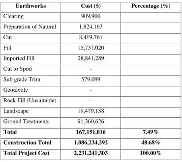
carried out, and the results from the study were included in this chapter. This case
study was important, because it provided the percentage of the construction costs in a
road project which enabled to calculate the cost/benefit analysis, in relation to the
proposed VRS expansion. Finally a business case was prepared, and the details were
included, in this chapter, to highlight, the findings and the importance of the
expansion of the existing VRS CORS Network in Queensland. Results of the data
analysis, about the construction projects, associated with the QDMR in Queensland,
are highlighted in this section, to discuss the clear suite of evidence for supporting the
main research topic.
4.2
Geographical Locations of QDMR projects.
A current list of all the construction projects, associated with QDMR was prepared, as
annexed in Appendix B under, QDMR projects and maps. Maps showing the main
road districts were printed in A4 and A3 sizes and the locations of the projects were
approximately marked, on the relevant maps. The main objective to mark these
locations on the maps was to find any clear suite of evidence for future VRS
expansion in Queensland.
The following observations were made from the above task;
1. During the study it was noted that, the projects to be marked, were only
needed, in the districts with a large area extent. Therefore, maps for
Cairns, Cloncurry, Barcaldine, Townsville, and Roma districts were
marked, with the relevant project locations, and these details were later
extracted into the figure 4.1.
2. Observations revealed that, all the other main road district headquarters
are located within, 300 km radius to each other, at the eastern side of
Queensland, as calculated from the map.
3. As identified from the detailed maps, the majority of the road
construction projects fall, around the main center of the each main road
4. Current and future road construction projects in Cairns, Cloncurry,
Townsville and Roma are sporadic and scattered projects.
5. A$40 million worth of construction projects are planned within 200km
from Cloncurry, in the next 4 years, while another A$10m project is
planned far away from the center.
6. A$31m road construction project is planned in Weipa, as shown on the
map, while significant amount of road projects are planned in or closer
to Cairns.
7. In Townsville, 6 out of 8 road construction projects are closer to the
town, while the other two are located away from the town.
8. The 5 circles drawn in red on figure 4.1 are indicative locations to
cover the whole area in south east Queensland, alongside the blue
circles which was drawn from the center of the major towns. These red
circles are approximately drawn from the center of the other minor
townships, in the local government areas.
The figure 4.1 shows the locations of main road district boundaries and the projects,
along with the extracted information from these individual maps. These individual
areas were then compared with each other, in relation to the range of road
constructions planned, budget allocations, total length of roads, population and the
area extents etc. Mining areas, farming, commercial and other social environments
were also, considered to give the recommendations about the future GPS
infrastructure needs.
4.3
Density and the Spread of QDMR projects.
Dots and the lines highlighted in orange, in figure 4.1 shows, the approximate
locations of the future QDMR projects in Queensland. Detailed information of all
these projects is available in Appendix B under QDMR projects and maps. Three of
the major projects in Cairns have been marked, with the budget allocations and the
durations. Similarly, locations of the projects in Cloncurry, Roma and Townsville
Figure 4. 1
Barcaldine are not available, through the QDMR website, at present. Approximate
locations of the projects for the above three districts marked on the map, revealed that
they are scattered in various parts of the districts. However, the construction projects,
at the eastern side of Queensland, are close to each other with comparing to the
projects at the northern and western sides of Queensland.
VRS expansion is not possible in the areas, with distant and scattered projects,
because of the investment on establishing GPS infrastructure cannot be justified,
whatsoever. Considering the facts, such as the budget allocations, durations of the
projects, future developments and the other potential users, a series of nodes or an
independent network may be implemented in these areas. Main road districts along the
coastal line from Nerang up to Mackey including, Toowoomba, Warwick and
Emerald are close to each other with comparing to the districts in northern and
western sides of Queensland which, may have a potential of a VRS expansion in to
these areas with the interpretation from the above map.
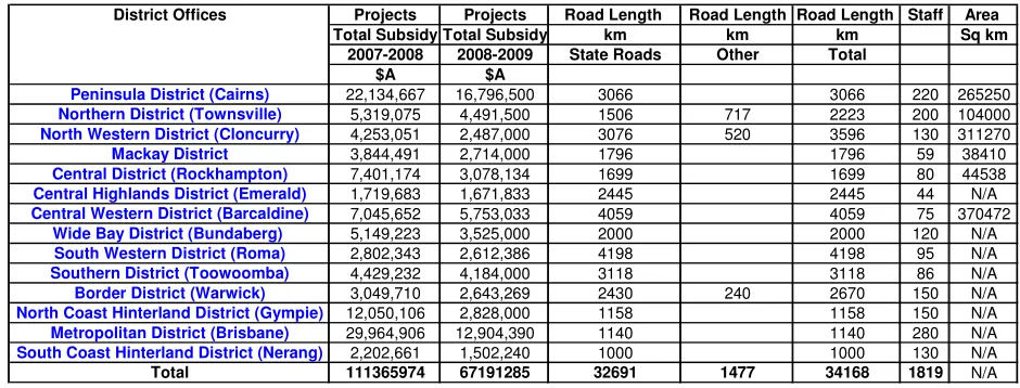
4.4 Locations and the subsidy allocations.
Subsidy allocations for the next five years for QDMR projects, under RIP program
were extracted, and tabulated with other data as shown in Table 4.1. This information
shows the immense amount of funds, already allocated into the road construction
projects in the coming years. With the knowledge gained, through the previous
chapters, it is apparent that more productivity gains, and cost savings can be obtained,
from these QDMR projects, by using the GPS machine guidance technology, under
GPS VRS environment. Subsidy allocations for road construction projects for
2007-2008 and 2007-2008-2009 periods were depicted as different types of graph presentations,
for easy reference and to explain the results/findings. Some of these graphs are
Figure 4.2 shows, the percentage of state roads in each district. It also reveals that the
maximum percentage of state roads is in Roma district and then follows, Barcaldine,
and Toowoomba. Cloncurry and Cairns while, the lowest percentage of state roads are
in Brisbane and Nerang Districts. With comparing the details in figure 4.2 with the
figure 4.3, the following observations were noticed.
• Brisbane with a lowest percentage of 3% roads in Queensland will
receive the highest investment of nearly A$ 43million, for the next 4
years, on road projects.
• Cairns will receive the second highest fund allocations with a
[image:46.595.104.574.365.544.2]percentage of 9% of roads in Queensland.
Table 4.1
Current Road Projects in Queensland 2007-2009 Undertaken by the Department of Main Roads, Queensland
District Offices Projects Projects Road Length Road Length Road Length Staff Area
Total Subsidy Total Subsidy km km km Sq km
2007-2008 2008-2009 State Roads Other Total
$A $A
Peninsula District (Cairns) 22,134,667 16,796,500 3066 3066 220 265250
Northern District (Townsville) 5,319,075 4,491,500 1506 717 2223 200 104000
North Western District (Cloncurry) 4,253,051 2,487,000 3076 520 3596 130 311270
Mackay District 3,844,491 2,714,000 1796 1796 59 38410
Central District (Rockhampton) 7,401,174 3,078,134 1699 1699 80 44538
Central Highlands District (Emerald) 1,719,683 1,671,833 2445 2445 44 N/A
Central Western District (Barcaldine) 7,045,652 5,753,033 4059 4059 75 370472
Wide Bay District (Bundaberg) 5,149,223 3,525,000 2000 2000 120 N/A
South Western District (Roma) 2,802,343 2,612,386 4198 4198 95 N/A
Southern District (Toowoomba) 4,429,232 4,184,000 3118 3118 86 N/A
Border District (Warwick) 3,049,710 2,643,269 2430 240 2670 150 N/A
North Coast Hinterland District (Gympie) 12,050,106 2,828,000 1158 1158 150 N/A
Metropolitan District (Brisbane) 29,964,906 12,904,390 1140 1140 280 N/A
South Coast Hinterland District (Nerang) 2,202,661 1,502,240 1000 1000 130 N/A
Total 111365974 67191285 32