FV 121214
Managing Adaptive REsponses to changing flood risk,
Work Package 2 – MARE City Partner Priorities
FV 121214
Compiled by:
John Blanksby, Pennine Water Group, University of Sheffield
Reviewed by:
FV 121214
Contents
1 Introduction ... 1
2 The process ... 1
2.1 Step 1: Identifying the key requirements of each partner ... 1
2.2 Step 2: Collating the results of Step 1 ... 1
2.3 Step 3: Prioritisation by city partners ... 1
2.4 Step 4: Four point classification ... 1
3 Conclusions and key messages ... 4
3.1 Coastal theme – Reference C1 ... 4
3.2 River theme – Reference R1 ... 4
3.3 River theme – Reference R5 ... 4
3.4 Surface water theme – References S2 and S3 ... 4
3.5 Non technical theme – References NT1, NT2 and NT3 ... 4
3.6 Other priorities... 4
3.7 Key messages. ... 4
Appendix 1. City partner wishes ... 5
FV 121214 1
1
Introduction
This report describes the activities carried out at the start of MARE to identify the
requirements of the city partners to help them manage current and future flood risk within their cities and build capacity for flood risk management.
The activities taken to do this were designed to enable the different city partners to highlight their own specific requirements and where appropriate to draw these together to provide a general context to help shape the delivery of the MARE Work Package 2 outputs, and their application in demonstration
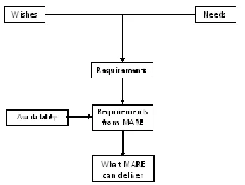
[image:5.842.91.266.347.479.2]projects, as illustrated in Figure 1.
Figure 1: the MARE work package 2 process
2
The process
The process for the needs and requirements analysis comprised 4 steps:
1. Identifying the key requirements of each city partner;
2. Collating the results of Step 1 into a consolidated list of requirements;
3. Circulation of the consolidated list to allow city partners to prioritise these in terms of importance and urgency where they saw fit;
4. To collate the scoring to classify the requirements in terms of importance and urgency in a four point scale.
2.1
Step 1: Identifying the key
requirements of each partner
Interviews were carried out with each of the city partners. The results of these interviews are presented in Appendix 1.
2.2
Step 2: Collating the results of
Step 1
The results were tabulated and consolidated into themes, which reflected as best as possible the emerging framework for sharing
knowledge and experience. The themes and needs can be seen in Tables 1 and 2.
2.3
Step 3: Prioritisation by city
partners
The consolidated list of requirements was circulated to the city partners. Two of the partners (Bergen and Dordrecht) were
particularly focussed on their specific issues so decided not to participate in this activity, but Hannover and the two English partners, Rotherham and Sheffield perceived that they had a common interest due to their inland location and carried out the prioritisation. Rotherham and Sheffield carried out their own initial assessments and then consolidated these into a single prioritisation. The results from Hannover and Rotherham/Sheffield are presented in Appendix 2.
2.4
Step 4: Four point
classification
FV 121214 2
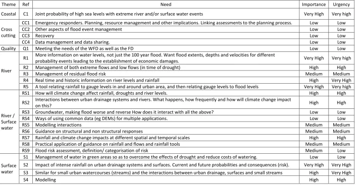
Table 1: Technical themes and needs
Priority groups
Theme Ref Need Importance Urgency
Coastal C1 Joint probability of high sea levels with extreme river and/or surface water events Very High Very high
Cross cutting
CC1 Emergency responders. Planning, resource management and other implications. Linking assessments to the planning process. Low Low
CC2 Other aspects of flood event management Low Low
CC3 Recovery Low Low
CC4 Data management and data sharing. Low Low
Quality Q1 Meeting the needs of the WFD as well as the FD Low Low
River
R1 More information on water levels, not just the 100 year flood. Want flood extents, depths and velocities for different
probability events leading to the establishment of economic damages. Very High Very high
R2 Management of both extreme flows and low flows (in time of drought) High High
R3 Management of residual flood risk Medium Medium
R4 Real time and historic information on river levels and rainfall High Very High
R5 A tool relating rainfall to gauge levels in and around urban area, and then relating gauge levels to flood levels Very High Very high
River / Surface water
RS1 How will climate change affect rainfall, droughts and river levels. High High
RS2 Interactions between urban drainage systems and rivers. What happens, how frequently and how will climate change impact
on this? High High
RS3 Groundwater, making flood worse and reverse How does it interact with all the above? Low Low
RS4 Ways of using common data (eg DEMs) for multiple applications. Low Low
RS5 Modelling interactions Medium Medium
RS6 Guidance on structural and non structural responses Medium Medium
RS7 Rainfall and climate change impacts at different spatial and temporal scales High High
RS8 Practical application of guidance on rainfall and flows and rainfall tools Medium Medium
RS9 Flood risk assessment, definition/ categorisation of risk Medium Low
Surface water
S1 Management of water in green areas so as to overcome the effects of drought and reduce costs of watering. Low Low S2 Impact of intense rainfall on urban drainage systems and surfaces. Current and future probabilities and consequences (risk). Very High Very High S3 Similar for small urban watercourses (streams) and the interactions between urban drainage, surfaces and small streams High Very High
FV 121214 3
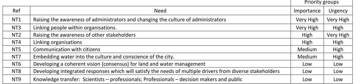
Table 2: Non technical needs
Priority groups
Ref Need Importance Urgency
NT1 Raising the awareness of administrators and changing the culture of administrators Very High Very High
NT3 Linking people within organisations. Very High High
NT2 Raising the awareness of other stakeholders High Very High
NT4 Linking organisations High High
NT5 Communication with citizens Medium High
NT7 Embedding water into the culture and conscience of the city. Medium High
NT6 Developing a coherent vision (consensus) for land and water management Low Low
FV 121214 4
3
Conclusions and key
messages
The MARE partners set out to address those issues which the city partners identified as having very high priority in terms of
importance or urgency in Tables 1 and 2. The actions taken are as follows:
3.1
Coastal theme – Reference C1
This need was specific to Bergen in Norway, and reports on the impact of climate change on sea levels and rainfall were produced (WP2). An approach to addressing the joint impact of high sea levels and extreme surface water events was tested in the case study entitled “The Lungegård lakes, transforming a fjord” (WP3).
3.2
River theme – Reference R1
This was addressed using the Adaptation Tipping Point Approach described in MARE 2 - Methods to attain flood protection standards (WP2). The benefits in carrying out a more detailed analysis than suggested in the EU Floods Directive are described in the case study entitled “The Hannover Flood Risk Management Study” (WP3).
3.3
River theme – Reference R5
This is outside the scope of the MARE project, but there is a significant amount of research being undertaken in this area.
3.4
Surface water theme –
References S2 and S3
These are addressed by a combination of the Adaptation Tipping Point Approach described in MARE 2 and in MARE 3 – “preparing for extreme events incorporating changing climate conditions”. Several of the case studies in WP3 address these issues.
3.5
Non technical theme –
References NT1, NT2 and NT3
These are addressed through the formation of Learning and Action Alliances (WP1), the approach and tools for the development of local strategies for managing flood risk (WP2) and in MARE1: “Water management and urban planning - Methods to improve inter- and transdisciplinary planning processes” (WP2). All of the case studies in WP3 contribute to these.
3.6
Other priorities.
Although not described here, many of the other priorities have been addressed in the
outputs of MARE and those of other projects like SAWA and SKINT in the North Sea Region and FRC in the North West Europe region.
3.7
Key messages.
FV 121214 5
Appendix 1. City partner wishes
Bergen
Bergen’s predominant wishes are to understand and quantify the range of potential climate change impacts on rainfall.
They have three main cases to consider.
Impacts on urban areas which cause surface water flooding, mainly from impervious surfaces. Typically the rainfall is short duration and very intense , and mainly occurs in summer;
Rainfall resulting in surface water runoff from green space into the urban area. This could be surface water and/or groundwater and typically there will be 50 mm depth of rainfall over a four hour period;
Rainfall resulting in flooding from rivers. In this case up to 200mm may fall over a period of 1 – 2 days and responses may involve the regulation of flows into and out of lakes;
In addition to the above Bergen also wish to receive guidance on joint probabilities (coastal surge and heavy rainfall) and the probability of consecutive extreme events.
Dordrecht
The Dordrecht alliance has identified three principal areas where they have needs.
Modelling
There is a need to identify the capacity and effectiveness of available modelling tools for application in urban flood risk management. As part of the assessment and guidance it will be necessary to consider the implications for data collection and management, how the urban flood risk assessment models can be linked to modelling tools covering other aspects of flood risk management and how the tools can be validated and models verified to legitimise the outputs.
Flood resistance and resilience and
disaster management
Guidance is required for individual measures and for linking portfolios of measures using cost benefit analysis to provide strategic options for flood risk management.
Tools and guidance for surface water
flood risk management.
There is a need for a range of tools and guidance for their use. The downscaling of daily and hourly rainfall generated by national tools to short temporal resolution rainfall is typical of what is needed.
Hannover
More information on high water levels, not just the 100 year flood. Want flood extents, depths and velocities for different probability events leading to the establishment of economic damages.
The current priority is river flooding, but there is also a need to know about surface water.
Communication with citizens.
Real time and historic information on river levels and rainfall.
A tool relating rainfall to gauge levels in and around Hannover, and then relating gauge levels to flood levels.
FV 121214 6
Embedding water into the culture and conscience of the city.
Ways of using common data (e.g., DEMs) for multiple applications.
How will climate change affect rainfall, droughts and river levels?
Interactions between urban drainage systems and rivers. What happens, how frequently and how will climate change impact on this?
Impact of intense rainfall on urban drainage systems and surfaces. Current and future probabilities and consequences (risk).
Similar for small urban watercourses and the interactions between urban drainage and streams.
Groundwater, making potential floods worse. How does it interact with all the above?
Emergency responders. Planning, resource management and other implications. Linking assessments to the planning process.
Other aspects of flood event management.
Recovery.
Data management and data sharing.
Linking people within organisations.
Linking organisations.
Knowledge transfer.
Scientists – professionals
Professionals – decision makers and public
Developing a coherent vision (consensus) for land and water management.
Raising the awareness of administrators and changing the culture of administrators.
Rotherham/Sheffield
The drivers for the current demonstration projects are regeneration and flooding within the high and medium probability of flooding areas along the River Don. However there is a need to consider flooding from other sources within the urban areas and the management of exceedance pathways in general and particularly in areas defended from river flooding. In this respect there is also a need to develop approaches to managing the residual risk, particularly from overtopping of
defences. For all these themes there is a need
for guidance on potential local responses in the form of adaptable measures, which will have no regrets outcomes.
Rainfall is an issue, and although current government guidance on allowing for climate change is shortly to be revised, a better understanding of the issues is needed. An improvement to the current UKCIP 09 rainfall tool is expected in spring 2010, and a review of how to apply this in demonstration projects (and beyond) may be beneficial.
From the opposite perspective there is also a need to develop a knowledge and experience base for drought proofing.
FV 121214 7
Appendix 2: Prioritisation by Hannover and Rotherham/Sheffield
Hannover ranking of priorities
Importance of technical needs
Ref Need Importance
C1 Joint probability of high sea levels with extreme fluvial and or pluvial events 23
CC1 Emergency responders. Planning, resource management and other implications. Linking assessments to the planning process. `14
CC2 Other aspects of flood event management 19
CC3 Recovery 20
CC4 Data management and data sharing. 22
Q1 Meeting the needs of the WFD as well as the FD 17
R1 More information on water levels, not just the 100 year flood. Want flood extents, depths and velocities for different probability events leading to
the establishment of economic damages. 1
R2 Management of both extreme flows and low flows (in time of drought) 10
R3 Management of residual flood risk 11
R4 Real time and historic information on river levels and rainfall 3
R5 A tool relating rainfall to gauge levels in and around urban area, and then relating gauge levels to flood levels 4
RS1 How will climate change affect rainfall, droughts and river levels. 8
RS2 Interactions between urban drainage systems and rivers. What happens, how frequently and how will climate change impact on this? 9
RS3 Groundwater, making flood worse and reverse How does it interact with all the above? 16
RS4 Ways of using common data (eg DEMs) for multiple applications. 15
RS5 Modelling interactions 12
RS6 Guidance on structural and non structural responses 13
RS7 Rainfall and climate change impacts at different spatial and temporal scales 2
RS8 Practical application of guidance on rainfall and flows and rainfall tools 18
RS9 Flood risk assessment, definition/ categorisation of risk 15
S1 Management of water in green areas so as to overcome the effects of drought and reduce costs of watering. 21
S2 Impact of intense rainfall on urban drainage systems and surfaces. Current and future probabilities and consequences (risk). 5
S3 Similar for small urban watercourses (streams) and the interactions between urban drainage, surfaces and small streams 6
FV 121214 8
Urgency of technical needs
Ref Need Urgency
C1 Joint probability of high sea levels with extreme fluvial and or pluvial events 23
CC1 Emergency responders. Planning, resource management and other implications. Linking assessments to the planning process. 14
CC2 Other aspects of flood event management 19
CC3 Recovery 20
CC4 Data management and data sharing. 22
Q1 Meeting the needs of the WFD as well as the FD 17
R1 More information on water levels, not just the 100 year flood. Want flood extents, depths and velocities for different probability events leading to
the establishment of economic damages. 1
R2 Management of both extreme flows and low flows (in time of drought) 10
R3 Management of residual flood risk 11
R4 Real time and historic information on river levels and rainfall 3
R5 A tool relating rainfall to gauge levels in and around urban area, and then relating gauge levels to flood levels 4
RS1 How will climate change affect rainfall, droughts and river levels. 8
RS2 Interactions between urban drainage systems and rivers. What happens, how frequently and how will climate change impact on this? 9
RS3 Groundwater, making flood worse and reverse How does it interact with all the above? 16
RS4 Ways of using common data (eg DEMs) for multiple applications. 15
RS5 Modelling interactions 12
RS6 Guidance on structural and non structural responses 13
RS7 Rainfall and climate change impacts at different spatial and temporal scales 2
RS8 Practical application of guidance on rainfall and flows and rainfall tools 18
RS9 Flood risk assessment, definition/ categorisation of risk 16
S1 Management of water in green areas so as to overcome the effects of drought and reduce costs of watering. 21
S2 Impact of intense rainfall on urban drainage systems and surfaces. Current and future probabilities and consequences (risk). 5
S3 Similar for small urban watercourses (streams) and the interactions between urban drainage, surfaces and small streams 6
FV 121214 9
Importance of non technical needs
Ref Need Importance
NT1 Raising the awareness of administrators and changing the culture of administrators -
NT2 Raising the awareness of other stakeholders -
NT3 Linking people within organisations. -
NT4 Linking organisations -
NT5 Communication with citizens 13
NT6 Developing a coherent vision (consensus) for land and water management -
NT7 Embedding water into the culture and conscience of the city. -
NT8 Developing integrated responses which will satisfy the needs of multiple drivers from diverse stakeholders -
NT9 Knowledge transfer: Scientists – professionals; Professionals – decision makers and public -
Urgency of non technical needs
Ref Need Urgency
NT1 Raising the awareness of administrators and changing the culture of administrators
NT2 Raising the awareness of other stakeholders
NT3 Linking people within organisations.
NT4 Linking organisations
NT5 Communication with citizens 4
NT6 Developing a coherent vision (consensus) for land and water management
NT7 Embedding water into the culture and conscience of the city.
NT8 Developing integrated responses which will satisfy the needs of multiple drivers from diverse stakeholders
FV 121214 10
Rotherham/Sheffield ranking of priorities
Importance of technical needs
Ref Need Importance
C1 Joint probability of high sea levels with extreme fluvial and or pluvial events 23
CC1 Emergency responders. Planning, resource management and other implications. Linking assessments to the planning process. 16
CC2 Other aspects of flood event management 21
CC3 Recovery 18
CC4 Data management and data sharing. 13
Q1 Meeting the needs of the WFD as well as the FD 17
R1 More information on water levels, not just the 100 year flood. Want flood extents, depths and velocities for different probability events leading to
the establishment of economic damages. 3
R2 Management of both extreme flows and low flows (in time of drought) 4
R3 Management of residual flood risk 14
R4 Real time and historic information on river levels and rainfall 7
R5 A tool relating rainfall to gauge levels in and around urban area, and then relating gauge levels to flood levels 2
RS1 How will climate change affect rainfall, droughts and river levels. 9
RS2 Interactions between urban drainage systems and rivers. What happens, how frequently and how will climate change impact on this? 5
RS3 Groundwater, making flood worse and reverse How does it interact with all the above? 20
RS4 Ways of using common data (eg DEMs) for multiple applications. 19
RS5 Modelling interactions 15
RS6 Guidance on structural and non structural responses 12
RS7 Rainfall and climate change impacts at different spatial and temporal scales 8
RS8 Practical application of guidance on rainfall and flows and rainfall tools 11
RS9 Flood risk assessment, definition/ categorisation of risk 24
S1 Management of water in green areas so as to overcome the effects of drought and reduce costs of watering. 22
S2 Impact of intense rainfall on urban drainage systems and surfaces. Current and future probabilities and consequences (risk). 1
S3 Similar for small urban watercourses (streams) and the interactions between urban drainage, surfaces and small streams 6
FV 121214 11
Urgency of technical needs
Ref Need Urgency
C1 Joint probability of high sea levels with extreme fluvial and or pluvial events 23
CC1 Emergency responders. Planning, resource management and other implications. Linking assessments to the planning process. 17
CC2 Other aspects of flood event management 22
CC3 Recovery 18
CC4 Data management and data sharing. 16
Q1 Meeting the needs of the WFD as well as the FD 15
R1 More information on water levels, not just the 100 year flood. Want flood extents, depths and velocities for different probability events leading to
the establishment of economic damages. 4
R2 Management of both extreme flows and low flows (in time of drought) 7
R3 Management of residual flood risk 14
R4 Real time and historic information on river levels and rainfall 6
R5 A tool relating rainfall to gauge levels in and around urban area, and then relating gauge levels to flood levels 2
RS1 How will climate change affect rainfall, droughts and river levels. 12
RS2 Interactions between urban drainage systems and rivers. What happens, how frequently and how will climate change impact on this? 8
RS3 Groundwater, making flood worse and reverse How does it interact with all the above? 21
RS4 Ways of using common data (eg DEMs) for multiple applications. 19
RS5 Modelling interactions 13
RS6 Guidance on structural and non structural responses 11
RS7 Rainfall and climate change impacts at different spatial and temporal scales 10
RS8 Practical application of guidance on rainfall and flows and rainfall tools 5
RS9 Flood risk assessment, definition/ categorisation of risk 24
S1 Management of water in green areas so as to overcome the effects of drought and reduce costs of watering. 20
S2 Impact of intense rainfall on urban drainage systems and surfaces. Current and future probabilities and consequences (risk). 1
S3 Similar for small urban watercourses (streams) and the interactions between urban drainage, surfaces and small streams 3
FV 121214 12
Importance of non technical needs
Ref Need Importance
NT1 Raising the awareness of administrators and changing the culture of administrators 1
NT2 Raising the awareness of other stakeholders 3
NT3 Linking people within organisations. 2
NT4 Linking organisations 4
NT5 Communication with citizens 7
NT6 Developing a coherent vision (consensus) for land and water management 5
NT7 Embedding water into the culture and conscience of the city. 6
NT8 Developing integrated responses which will satisfy the needs of multiple drivers from diverse stakeholders 9
NT9 Knowledge transfer: Scientists – professionals; Professionals – decision makers and public 8
Urgency of non technical needs
Ref Need Urgency
NT1 Raising the awareness of administrators and changing the culture of administrators 2
NT2 Raising the awareness of other stakeholders 1
NT3 Linking people within organisations. 3
NT4 Linking organisations 6
NT5 Communication with citizens 5
NT6 Developing a coherent vision (consensus) for land and water management 7
NT7 Embedding water into the culture and conscience of the city. 4
NT8 Developing integrated responses which will satisfy the needs of multiple drivers from diverse stakeholders 9