UNIVERSITI TEKNIKAL MALAYSIA MELAKA
DEVELOPMENT OF UTEM BUS TRACKING SYSTEM USING
GSM AND GPS MODULES
This report is submitted in accordance with requirement of the Universiti Teknikal Malaysia Melaka (UTeM) for the Bachelor of Electronic Engineering
Technology (Telecommunication) with Honours
by
CHEW YI CHING B071410253 940619-02-5915
UNIVERSITI TEKNIKAL MALAYSIA MELAKA
BORANG PENGESAHAN STATUS LAPORAN PROJEK SARJANA MUDA
TAJUK: Development Of UTeM Bus Tracking System Using GSM And GPS
Modules
SESI PENGAJIAN: 2017/18 Semester 1
Saya CHEW YI CHING
mengaku membenarkan Laporan PSM ini disimpan di Perpustakaan Universiti Teknikal Malaysia Melaka (UTeM) dengan syarat-syarat kegunaan seperti berikut:
1. Laporan PSM adalah hak milik Universiti Teknikal Malaysia Melaka dan penulis. 2. Perpustakaan Universiti Teknikal Malaysia Melaka dibenarkan membuat salinan
untuk tujuan pengajian sahaja dengan izin penulis.
3. Perpustakaan dibenarkan membuat salinan laporan PSM ini sebagai bahan pertukaran antara institusi pengajian tinggi.
4. **Sila tandakan ( )
SULIT
TERHAD
TIDAK TERHAD
(Mengandungi maklumat yang berdarjah keselamatan atau kepentingan Malaysia sebagaimana yang termaktub dalam AKTA RAHSIA RASMI 1972)
(Mengandungi maklumat TERHAD yang telah ditentukan oleh organisasi/badan di mana penyelidikan dijalankan)
Alamat Tetap:
Ban Eng Hin, Jalan Lana Bulu,
Simpang Empat Kerpan, 06150
Alor Setar, Kedah.
Tarikh: ________________________
Disahkan oleh:
Cop Rasmi:
Tarikh: _______________________
i
DECLARATION
I, hereby, declared this report entitled “Development Of UTeM Bus Tracking System Using GSM And GPS Moludes” is the results of my own research except as cited in references.
Signature : ………
Name : ………
ii
APPROVAL
This report is submitted to the Faculty of Engineering Technology of UTeM as a partial fulfilment of the requirements for the degree of Bachelor of Electronic Engineering Technology (Telecommunications) with Honours. The member of the supervisory is as follow:
………. Mr. Mohd Faizal Bin Zulkifli
iii
ABSTRAK
Pada masa kini, perkhidmatan pengangkutan bas UTeM mempunyai sistem maklumat pengangkutan yang tidak lengkap. Di UTeM, kebanyakan pengguna bas perlu menunggu di perhentian bas dengan waktu yang lama kerana mereka hanya mengetahui jadual waktu ketibaan bas dan biasanya bas tidak akan tiba pada masa yang tepat seperti masa yang dinyatakan. Matlamat saya adalah untuk membangunkan sistem pengesanan bas dengan menggunakan modul GPS dan GSM untuk
memudahkan pelajar di UTeM. Jadi pelaksanaan sistem pengesanan bas UTeM telah
dibangunkan. Sistem pengesanan bas UTeM adalah sistem yang digunakan untuk
mendapatkan koordinat bas UTeM dan pelokasi sumber seragam peta google dalam bentuk SMS apabila pelajar meminta lokasi bas UTeM melalui menghantar SMS ke sistem. Pelajar boleh mengklik pada pelokasi sumber seragam peta google yang dibalaskan oleh sistem dengan berhubung dengan internet untuk mendapat lokasi bas UTeM di peta google. Dalam projek ini, modul GSM digunakan untuk menerima SMS dari pelajar dan menghantar semula SMS kepada pelajar. Modul GPS digunakan untuk mendapatkan koordinat bas UTeM. Sementara itu, Arduino Uno digunakan sebagai pengawal mikro dalam projek ini kerana ia kos rendah dan fakta mesra pengguna. Pada masa akan datang, aplikasi android juga boleh dilaksanakan untuk memperbaiki
sistem ini dengan menyediakan lokasi dinamik bas UTeMdalam peta google kepada
iv
ABSTRACT
v
DEDICATION
To my beloved parents, Chew Chin Nam and Tan Bee Ee
vi
ACKNOWLEDGEMENT
First and foremost, I would like to take this opportunity to express my appreciation to those who helped me to complete my project. I would like to thank my supervisor Mohd Faizal Bin Zulkifli and co-supervisor Ahmad Sayuthi Bin Mohammad Shokri who are from Electronic and Computer Engineering Technology Derpartment in UTeM for the significant guidance, patience and suggestion to make sure that my project achievable. I have gain a lot of information and knowledge from both of my lectures along this project.
vii
TABLE OF CONTENT
DECLARATION i
APPROVAL ii
ABSTRACT iii
ABSTRAK iv
DEDICATIONS v
ACKNOWLEDGEMENT vi
TABLE OF CONTENT vii
LIST OF TABLES xi
LIST OF FIGURES xii
LIST OF ABBREVIATIONS, SYMBOLS AND NOMENCLATURE xiv
CHAPTER 1: INTRODUCTION 1
1.0 Background 1
1.1 Problem Statement 3 1.2 Objective 3
1.3 Scope 4
CHAPTER 2: LITERATURE REVIEW 5
2.0 Introduction 5
2.1 Overview of tracking system 5
2.2 Previous Related Work 6
2.2.1 “Real Time Metroplitan Bus Positioning System design using GPS and GSM” by B.Janarthanan & T.Santhanakrishhan. 6 2.2.2 “Development of Vehicle Tracking system using GPS and
viii
and Nguyen Chi Cuong. 7
2.2.3 “A Mobile Application for Bus Information System and Location Tracking using Client-Server Technology” by Yasha Sardey, Pronoti Deshmukh, Pooja Mandlik, Saurabh Shelar and Minal Nerkar. 9
2.3 Global Positioning System (GPS) 13
2.3.1 GPS overview 13
2.3.2 Three segment of GPS 14
2.4 GSM (Global System For Mobile Communication) 15
2.5 Hardware specification 16
2.5.1 GPS module 16
2.5.1.1 U-blox NEO-M8N GPS module 16
2.5.1.2 Comparison between U-blox GPS NEO-M8N and U-blox NEO-6M modules 18
2.5.2 GSM module 20
2.5.3 Microcontroller 22
2.5.3.2 Comparison between Arduino Uno and PIC 16F877A microcontroller 22
2.5.3.2 Comparison between Arduino Uno and Arduino Nano 23
2.5.3.3 Arduino Uno 24
CHAPTER 3: METHODOLOGY 27
3.0 Introduction 27
3.1 Planning 28
3.1.1 Work plan of the project 28
3.1.2 Data collection 31
3.2 Design 32
ix
3.3 Implement 33
3.3.1 Project implementations 33
3.4 The Operation Flowchart 34
CHAPTER 4: RESULTS AND DISCUSSION 35
4.0 Introduction 35
4.1 Schematic Diagram and Wiring Diagram 35
4.2 Bus tracking system hardware design 37
4.3 Software Implementation 38
4.3.1 Programing Language 38
4.3.2 Programming Coding 38
4.4 Results 43
4.5 Data Analysis 45
4.5.1 Analysis on time response of GSM module in different distance 45 4.5.2 Analysis on the accuracy of GPS module in different location 47 4.5.3 Analysis on student’s satisfaction to the performance of the
UTeM bus tracking system 51 4.5.3.1 Time response of the UTeM bus tracking system 52 4.5.3.2 Important of google maps link 52 4.5.3.3 Student’s satisfaction 54
4.6 Discussion 55
4.7 Limitation 57
CHAPTER 5: CONCLUSION AND FUTURE WORK 58
5.0 Introduction 58
5.1 Conclusion 58
x
APPENDIX A 61
APPENDIX B 65
APPENDIX C 67
xi
LIST OF TABLES
2.1 Pin definition of U-blox NEO-M8N GPS module 17 2.2 Comparison between U-blox NEO-M8N and U-blox
NEO-6M GPS modules 19 2.3 Technical detail of GSM SIM 900A module 21 2.4 Comparison between Arduino Uno and Arduino Nano 23
2.5 Technical Specification of Arduino Uno 25
2.6 Pin with specialized function 26
3.1 Gantt chart of progress of final year project 29
4.1 The time response of GSM module when the UTeM bus
in 6 different locations that will pass through by UTEM bus 45
xii
LIST OF FIGURES
2.1 Functional block diagram 7
2.2 Vehicle tracking system block diagram
8
2.3 Architecture of location based service 9
2.4 Client-Server Technology in Android 10
2.5 Flowchart for module 1 11
2.6 Flowchart for module 2 12
2.7 GPS segments 15
2.8 U-blox NEO-M8N GPS module 17
2.9 SIM900A GSM module 20
2.10 Front view of the Arduino Uno 24
2.11 The Arduino Uno board with part label 25
3.1 Major step in methodology 27
3.2 Flowchart of overall flow of PSM 30
3.3 Block diagram of bus tracking system 32
3.4 The operation of the project 34
4.1 Schematic diagram 36
4.2 Wiring diagram 36
4.3 The connection between the Arduino Uno, GPS and GSM modules by using wires 37
4.4 The Arduino Programing Language 38
4.5 The libraries and the pin declaration 39
4.6 Coding for void setup 39
xiii
4.8 The GPS function 41
4.9 The Send_sms function 41
4.10 The program loop 42
4.11 Message reply by the GSM module 43
4.12 The location of the UTeM bus shows in google maps 43 4.13 The response of the GSM module when receive invalid input 44 4.14 The graph of time response when the UTeM bus at different location 46 4.15 Figure on left showing the coordinates from smart phone and the
figure on right showing the coordinates obtains from GPS module
in BUNGA RAYA 47
4.16 Figure on left showing the coordinates from smart phone and the figure on right showing the coordinates obtains from GPS module
in SRI UTAMA 48
4.17 Figure on left showing the coordinates from smart phone and the figure on right showing the coordinates obtains from GPS module
in FALCULTY ENGINEERING TECHNOLOGY 48
4.18 Figure on left showing the coordinates from smart phone and the figure on right showing the coordinates obtains from GPS module
in SPORT COMPLEX 49
4.19 Figure on left showing the coordinates from smart phone and the figure on right showing the coordinates obtains from GPS module
in DEWAN CANSELOR 50
4.20 Figure on left showing the coordinates from smart phone and the figure on right showing the coordinates obtains from GPS module
in EMERALD PARK 50
4.21 The google survey form 51
xiv
LIST OF ABBREVIATIONS, SYMBOLS AND
NOMENCLATURE
USB - Universal Series Bus GSM - Global System Mobile GPS - Global Positioning System SMS - Short Message System QR - Quick Response
UART - Universal Asynchronous Receiver AVR - Advanced Virtual RISC
GLCD - Graphical Liquid Screen Display ARM - Advanced RISC Machines SPI - Serial Peripheral Interfaces DC - Direct Current
PCB - Printed Circuit Board
GND - Ground
VCC - Power Supply RXD - Receive Data TXD - Transmit Data
PCS - Personal Communication Services HDTV - High-Definition TV
1
CHAPTER 1
INTRODUCTION
1.0 Background
Since from the last past century, transportation becomes a necessary object that needed by humans. Among all public transportation service, bus service is the most easy, convenient and low price transportation in the busy town. This service is the major transportation used by the public. Nowadays some bus transportation service has very poor transportation information system. Most of bus user needs to wait at bus stop with a long time because they only know the scheduled of the bus arrival time but usually the bus did not arrive on time as the time stated. In addition, most of bus transportation system does not have a proper system that can show the position of the bus and calculate the bus arrival time compare to flight and train transportation system.
2
However, the current bus services in UTeM still need to be improved because the student cannot track the location of the bus. When student want to take bus, they need to wait at the bus stop before the time stated in the manual bus schedule. Sometimes, the bus may be delay or arrived late. Student may miss their class because they cannot estimate the bus arrival time. In comparison to university WEST CHESTER in United State, UTeM do not used any system or application to track all their buses position in every bus stop.
In order to solve the current problem of bus service system, bus tracking system must be develop and implement to help UTeM’s student to have better bus service. With this bus tracking system the UTeM’s students just need send a message to the GSM module, then the GPS module will send the data related to tracking position in real time, and it will send the data to the GSM module. After that, the GSM module will reply a message with coordinate and a google maps link to the mobile phone. Lastly, the student just need click the link with internet access, the mobile phone will show the location of the bus in google maps and the student can further estimate the bus arrival time.
3 1.1 Problem Statement
One of the problem that occur in current UTeM bus service is the student only know the bus schedule but do not know the exact time for bus arrival. According to the survey was made to 30 responses at bus stop UTeM about the bus services, 73.33% of student said that the bus normally not arrives at the expected time. The students need to wait at bus stop without knowing the location of the bus and what time the bus will arrive. In this situation the student waste a lot of time waiting at the bus stop. Most of the times students felt anxious and impatient when they rush for class but the bus does not arrive on time.
Furthermore, the safety of the student will be at risk while waiting at the bus stop for a long time. According to survey has been made, 63.33% of students said that waiting at bus stop for a long time will increase the chance of getting robbed. Based on the BORNEO POST online posted 6 October 2016, a 15-year-old boy was waiting at a bus stop near his school along Jalan Tun Jugah around 1.50pm when two men threatened him with a pair of scissors into surrendering his wallet and mobile phone.
1.2 Objective
Based on the problem statement discussed above, the objectives of this study are:
i. To understand about the GPS and GSM tracking technology and bus transportation system in UTeM.
4 1.3 Scope
5
CHAPTER 2
LITERATURE REVIEW
2.0 Introduction
In this chapter, the purpose is to reviews on some of the various significant works that had been done by other researcher and relevant to the bus tracking system and conclude all the information that found in the literature. Based on the literature, the research and fact finding that obtain can be used to support this projects. Therefore, literature review plays an important role when this project is carried out.
2.1 Overview of tracking system
6 2.2 Previous Related Work
2.2.1 “Real Time Metroplitan Bus Positioning System design using GPS and GSM” by B.Janarthanan & T.Santhanakrishhan
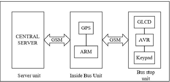
B.Janarthanan and T.Santhanakrishhan have proposed the real time metropolitan bus position system design using GPS and GSM. The real time bus monitoring and passenger information bus tracking device is a system that will displayed the GPS data of the bus locations in the GLCD screen at the bus stop when the user request. The equipment that used in this system consists of backup battery, GSM module, ARM7 microcontroller, AVR microcontroller, GPS module and GLCD screen. Three major part are consists in this bus positioning system those are inside bus unit, bus stop unit and central control.
7
Figure 2.1: Functional block diagram (Janarthanan and Santhanakrishnan, 2014)
2.2.2 “Development of Vehicle Tracking system using GPS and GSM modem” by Pham Hoang Dat, Micheal Drieberg and Nguyen Chi Cuong
[image:23.596.194.518.78.235.2]8
Figure 2.2: Vehicle tracking system block diagram (Pham, Drieberg and Nguyen, 2013)
The u-blox NEO-6Q GPS module is the heart in the proposed system which used to obtains the vehicle’s coordinates. The coordinates that received from the GPS module will send to Arduino Uno microcontroller. Then the Arduino Uno microcontroller will send the coordinate to the LEON-G100 GSM to be transmitted through the mobile network to the user when user requested.
[image:24.596.190.521.74.262.2]