MODERN CADASTRE IN MALAYSIA
( PEMBANGUNAN SISTEM PEMILIHAN DAN
VISUALISASI PANGKALAN DATA KADASTER BAGI
MENYOKONG PERLAKSAAN KADASTER MODEN DI
MALAYSIA)
Dr Abdullah Hisam Omar
Prof Dr Abd Majid A Kadir
Mr Rosnizam Mudin Shah b Sidek
IRPA VOTE NO :
74270
FAKULTI KEJURUTERAAN DAN SAINS
GEOINFORMASI
Universiti Teknologi Malaysia
81310 UTM SKUDAI, JOHOR
Engineering, Faculty of Geoinformation Science and Engineering, Universiti Teknologi Malaysia. The research was funded by the Ministry of Science, Technology and Inovation under the e-IRPA (Intensification of Research Priority Area ) 8h Malaysian Plan. The authors wish to express their sincere appreciation to all individuals involved during the preparation and execution of this research for their assistance, contribution and making this research a success. Throughout the duration of this research, assistance from research colleagues and staff members were received and acknowledge.
Project Leader : Dr Abdullah Hisam Omar Researcher : 1. Prof Dr Abd Majid A Kadir
( Keyword: Cadastral Database, Automated Process, Modern Cadastre, NDCDB)
The process of extracting land records information especially cadastral data for a large number of land title was tedious and time consuming. The development of State Digital Cadastral Database (SDCDB) by Department of Survey and Mapping Malaysia (DSMM) is one of the initiatives to shift to modern cadastral system. Cadastral data need to be adjusted in order to verify the network closure. In order to move to a new adjustment approach, a so-called Least Squares, an Intelligence Based Automated Cadastral Database Conversion System must be developed. The automated functions of the said system are;i) generate of zones and overlapping areas, ii)extracting cadastral information from existing SDCDB,iii) automatically conduct an intelligence cadastral survey concept self- checking procedure, iv) re-compute or rebuild the cadastral records based on mathematical cadastral survey rules, v) automatically prepare corrected data input files ( SDCDB and GPS) for a particular zone and vi) reformatting of data for input into least squares adjustment software.
The advantages of automation can be exploited in order to solve or to minimize the needs of manual approach. In order to support the development of survey accurate cadastral system, an automatic programming approach will be adopted. Database selection system will conduct several outliers integrity checking, rebuild cadastral spatial topology (cadastral lot) and make self-correction procedures based on cadastral survey concepts and mathematical model respective to the cadastral lots selected. This is to ensure that all cadastral lots are kept in a closed polygon and provide accurate and "clean" cadastral information.. This system was developed in windows environment.
Analyses show that the system is functional efficiently. This system is essential and important towards the implementation of computerized Coordinated Cadastral System in Malaysia and it is highly depends on the automated system.. Therefore an Intelligence Based Automated Cadastral Database Selection System is highly potential as a main system application for DSMM or private sector.
Key Researcher :
Dr. Abdullah Hisam Omar (Head) Prof. Dr. Abd Majid A Kadir En. Rosni Zamuddin Shah Bin Sidek
E-mail : [email protected] Tel. No. : 07-5530945
Proses pengekstrakan maklumat rekod berkaitan tanah terutamanya data kadaster bagi kawasan yang besar melibatkan tempoh masa yang lama serta tenaga yang banyak. Pembangunan Pangkalan Data Kadaster (PDUK) oleh Jabatan Ukur dan Pemetaan Malaysia (JUPEM) merupakan satu inisiatif kearah system kadaster moden di Malaysia. Kadaster data perlu dilaraskan bagi mempastikan tutupan jaringan. Bagi mengubah pendekatan pelarasan yang baru iaitu menggunakan pelarasan ganda dua terdikit, Sistem Pemilihan dan Visualisasi Pangkalan Data Kadastra Secara Automasi telah dibangunkan. Fungsi-fungsi automatic yang terlibat adalah: i)menjanakan zon dan kawasan tindihan, ii) mengekstrak maklumat kadaster fari PDUK, iii) melaksanakan prosedur penyemakan konsep ukur kadaster secara automatic, iv) mengira dan membangunkan rekod kadaster berasaskan model matematik ukur kadaster, v) menyediakan input data yang telah diperbetulkan (PDUK dan GPS) bagi zon terlibat, vi) memformat input data bagi perisian pelarasan ganda dua terdikit.
Kelebihan-kelebihan automasi boleh diekploitasikan untuk menyelesaikan dan meminimakan keperluan pendekatan manual. Bagi menyokong pembangunan sistem ukur kadaster berketepatan tinggi, pendekatan pengaturcaraan automatik telah diaplikasikan. Sistem Pemilihan Pangkalan Data melaksanakan beberapa prosedur penyemakan integriti, membentuk topologi spatial ( lot kadaster) serta pembetulan cerapan berasaskan model matematik serta peraturan ukur kadaster bagi lot kadaster yang terlibat. Ini bagi memastikan kesemua lot kadaster disimpan didalam bentuk poligon tertutup dan menyediakan maklumat kadaster yang tepat dan ”bersih”. Senario ini kritikal di dalam proses pelarasan. Sistem ini dibangunkan berasaskan persekitaran
windows.
Analisis-analisis menunjukkan sistem ini berfungsi secara efisyen. Sistem ini merupakan asas dan penting kearah implementasi Sistem Kadaster Berkoordinat berkomputer di Malaysia dan amat bergantung kepada sistem automasi. Oleh itu Sistem Pemilihan dan Visualisasi Pangkalan Data Kadastra Secara Automasi berpotensi sebagai sistem aplikasi utama bagi JUPEM atau sektor swasta.
Penyelidik :
Dr. Abdullah Hisam Omar (Ketua) Prof. Dr. Abd Majid A Kadir En. Rosni Zamuddin Shah Bin Sidek
E-mail : [email protected] Tel. No. : 07-5530945
CHAPTER TITLE PAGE
TITLE PAGE i
ACKNOWLEDGEMENTS ii
ABSTRACT iii
ABSTRAK iv
CONTENTS v
LIST OF FIGURES viii
LIST OF TABLES xi
LIST OF ABREVIATIONS xii
LIST OF APPENDICES xv
1 INTRODUCTION 1
1.1 Introduction 1
1.2 Research Objectives 5
1.3 Problem Statement 5
1.4 Research Scope 6
1.5 Research Contributions 6
1.6 Research Methodology 7
2.3 Common Aspects of Cadastral Reform and Trends 14
2.4 Global Cadastral Reform 15
2.4.1 Landonline in New Zealand 18 2.4.2 Cadastral Electronic Field Book (CEFB)
in Florida
20
2.4.3 ArcCadastre System in Colombia 21 2.4.4 Cadastral Reform in Canada 22 2.4.5 Cadastral Reform in Asia Pacific Region 23
2.5 Cadastral Reform in Malaysia 25
2.5.1 Office Reforms 26
2.5.2 Field Reforms 30
3 DIGITAL CADASTRAL DATABASE 35
3.1 Introduction 35
3.2 Digital Cadastral Database (DCDB) 37 3.2.1 DCDB Data Structure Overview 39
4 DEVELOPMENT OF AUTOMATED CADASTRAL
DATABASE SELECTION AND VISUALIZATION SYSTEM
45
4.1 Introduction 45
4.2 Database Selection and Visualization Design 46
4.2.1 Arcview 46
4.2.2 Map Object 53
4.2.3 Visual Basic 58
4.2.4 Mathematical Model 60
4.3 Data Selection and Visualization Interfacing Program (CDSV)
65
5.2 Data Quality 80
5.2.1 Cleanliness of data 80
5.2.2 Data Accuracy 80
5.3 Cadastral Database Selection and Visualization Prototype
82
5.4 Analysis of Data Input: Adjusted Cadastral Network
85
6 CONCLUSION AND RECOMMENDATIONS 88
6.1 Introduction 88
6.2 Details Findings 88
6.2.1 State Digital Cadastral Database 88 6.2.2 Cadastral Database Selection Application 90
6.3 Recommendations 92
REFERENCES 93
FIGURE NO. TITLE PAGE
2.1 Landonline e-Survey process 19
2.2 Virtual Survey System 29
2.3 Cadastral survey process before 70’s 31 2.4 Three stages for cadastral survey workflow before
70’s
31
2.5 Cadastral survey process during 80’s 32 2.6 Cadastral survey process using earlier version of F2F
during 90’s. 34
3.1 Flowchart of NDCDB Development 36
3.2 The Design Process of DCDB 41
3.3 The Process of Building The E-R Diagram 43 3.4 Example of Physical Database Model for DCDB 44
4.1 Research Area 45
4.2 The ArcView Screen 46
4.3 ArcView Starts With An Empty Window 49
4.4 Open Project Dialog Box 49
4.5 The Title Project (qstart.apr) Appear In The ‘Project Window’
50
4.6 View of Project With Interactive Map And Various Features (Themes)
50
4.7 The MapObject Screen(a) and (b). MapObject Application
53
4.8 The Visual Basic Screen 58
4.9 Visual Basic Code Is Written In The Code Window 60
4.12 Relationship Between Two Different Scale Factors 65
4.13 Database Selection and Visualization System 66 4.14 Overall Data Selection Unified Modeling Language 67 4.15 Data Selection Methodology and Editing 67
4.16 Spatial Properties Menu 68
4.17 Main Menus of CDSV 68
4.18 Reformating Menus 69
4.19 Spatial Selection 69
4.20 Identify Spatial Information 70
4.21 Cadastral Network Record 70
4.22 Creating Input File for NDCDB (Point File) 71 4.23 Creating Input File for NDCDB (Boundary File) 71 4.24 Creating Input File for NDCDB (Combine File) 72 4.25 : Running Starnet Least Squares Adjustment Software
From Prototype System
72
4.26 NDCDB Implementation Methodology 74
4.27 (a) StarNetTM Report (ndcdb.lst) 74 4.27 (b) Input Data of Adjusted Coordinate 75 4.27 (c) Input Data of Adjusted Observation 75
4.28 StarNet Report (ndcdb.ref) 75
4.29 Visual Basic interface to extract data from StarNet Report (ndcdb.lst and ndcdb.ref)
76
4.33 Avenue programme of pl_ndcdb.txt for creating polyline
78
4.34 Avenue programme of cvtplply.txt for converting polyline to polygon
78
5.1 (a) The adjusted boundary line (ndcdb_bdy.dbf) file input in ArcView
82
5.1 (b) The adjusted boundary line (ndcdb_bdy.dbf) file input in ArcView
82
5.1 (c) The adjusted boundary mark (ndcdb_sto.bdy) file 82 5.2 View of a new Theme based on boundary line
database (ndcdb_bdy.dbf) 83
5.3 Attributes of the GIS DCDB 84
5.4 Identifying the attributes 84
5.5 NDCDB for large cadastral network generated using CDSV
85
5.6 Adjusted Coordinates for Boundary Mark 86 5.7 Overlay Analysis Between Existing DCDB and
NDCDB Cretaed by CDSV Prototype.
3.1 DCDB Out-Source Format 40
3.2 Out-Source ASCII file 40
3.3 DCDB Master Data List 42
3.4 Basic elements of the Logical Data Model 43
3.5 Logical Scheme For DCDB 44
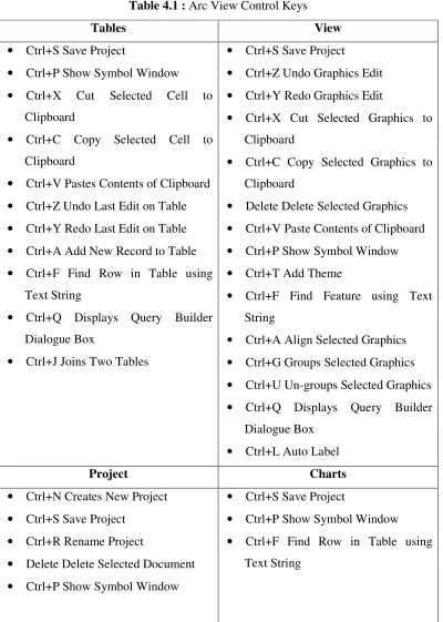
4.1 Arc View Control Keys 51
5.1 Example of Observation Statistic 85
5.2 Summary of Adjustment Result 86
CP - Certified Plan CV - Calculation Volume CAD - Computer Aided Design
CALS - Computer Assisted Land Survey System CAM - Computer Aided Mapping
CCS - Coordinated Cadastral System CCI - Cadastral Control Infrastructure CCDB - Cadastral Control Database
CDMS - Cadastral Database Management System
CDSV - Data Selection and Visualization Interfacing Program CEFB - Cadastral Electronic Field Book
CLRS - Computerised Land Registration System CMM - Cadastral Measurement Management CSS - Counter Service System
DBMS - Database Management System
DSMM - Department of Survey and Mapping Malaysia EDM - Electronic Distance Measurement
E-R - Entity-Relationship
GDM2000 - Geocentric Datum of Malaysia GIS - Geography Information System
IGAC - Geographical Institute Agustin Codazzzi INAC - Northern Affairs Canada
IT - Information Technology LINZ - Land Information New Zealand LIS - Land Information System LSA - Least Squares Adjustment
MACGDI. - Malaysian Center For Geospatial Data Infrastructure NaLIS - National Infrastructure for Land Information System NDCDB - National Digital Cadastral Database
NGDI - National Geospatial Data Infrastructure NRCan - Natural Resources Canada
SAPD - District Survey Office Automation System SDCDB - State Digital Cadastral Database
SKDK - Digital Cadastral Integrity System SPID - Image Document Management System SRIS - Survey Record Information System SUM - Virtual Survey System
TSM - Total Survey Module
VB - Visual Basic
A CDSV 100
CHAPTER I
INTRODUCTION
1.1 Introduction
Sustainable development has been, since not too long ago, the concern of most nations as it was accepted as one of the factors affecting human survival. In ensuring sustainable development, the cadastre has been widely recognised as having an important role to play and this had consequently imposed increasing demands on the traditional cadastral systems. As a result, the need then arises for cadastral systems to adapt to new expectations and standards and particularly to implement improved cadastral systems. This situation had, amongst other reasons, led to the many ongoing cadastral reforms throughout the world, over the last decade or so (Kaufmann, 1999).
Williamson (1991), arguably the largest number of papers presented, dealt with the common theme on cadastral reforms.
Malaysia was not to be left behind in this progressive development. Spurred on by domestic demands and taking cue from developments overseas, it had unceasingly taken initiatives to continually and strategically implement cadastral reforms whenever and wherever appropriate. One fitting example was the introduction of computerised systems to the surveying component of the cadastre by the Department of Survey and Mapping, Malaysia (DSMM). According to Abdul Majid Mohamed (1994), the initiative was for the purpose of not only increasing the efficiency and productivity of computations and plan drawings, but also to introduce the concept of digital databases. That first step was then accompanied by other initiatives by the same department through the continuous and still on-going reforms of the cadastral surveying system. The most recent of these initiatives is the endeavour to introduce the Coordinated Cadastral System (CCS) for the purpose of further improving and increasing the efficiency of the cadastral surveying system (Abd Majid A. Kadir et.al., 1998).
The benefits of CCS have been much talked about and these include the opening up of opportunities in coping with and in accruing benefits from the advances in technology. One example is its compatibility for use with modern survey equipments and systems. Since coordinates are the basic input/output of equipments such as Electronic Total Stations and systems such as the Global Positioning System (GPS), the introduction of CCS would thus be synergistic with the operations of such equipments and systems. Moreover, it will also facilitate the integration of cadastral and map-based information as well as the use of rapid data acquisition, storage, processing and management techniques. Apart from that, much of the developed world have also recognised that the CCS underpins the Land/Geographical Information System (LIS/GIS), and in considering that land/geographic information itself is a very valuable resource, it is evident that the CCS is of essence.
In view of the above developments, it is consequently the intention of this study to look into the various aspects of the introduction and implementation of the CCS in Malaysia. Since the practises and operations of the cadastre in the states of Peninsular Malaysia are distinctly different from those of Sabah and Sarawak in East Malaysia, due to historical (and constitutional) reasons, this study is thus specifically confined to Peninsular Malaysia.
The cadastral reform is inevitable in this new millennium to handle and manage the constant proliferation throughout the world. This is to some extent due to technological advancement in computerization, information acquisition and communication. Cadastral reform may relate to various aspects of cadastral system such as office automation, field measurement, and cadastral database development. These will lead to the concept and realization of the Coordinated Cadastral System (CCS) in some countries today.
to technological advancement in computerization, information acquisition and communication. Cadastral reform may relate to various aspects of cadastral system such as office automation, field measurement, and cadastral database development. These will lead to the concept and realization of the Coordinated Cadastral System (CCS) in some countries today.
In the previous studies of CCS (1997-1999), main input data for cadastral network adjustments are bearing and distance for boundary lots which have been keyed-in manually. This method is not practical to be implemented on the large cadastral network due to tedious task and time consuming. The existence of the State Digital Cadastral Database (SDCDB) that has been developed by DSMM has triggered the idea to develop one system that can be applied leading to automated system for data conversion.
1.2 Research Objectives
i. To develop an Intelligence Based Database Integrity and Self Correction Mechanisms.
ii. To develop an Intelligence Based Cadastral Database Selection and Visualization System.
1.3 Problem Statement
The process of extracting land records information especially cadastral data for a large number of land title was tedious and time consuming. The development of State Digital Cadastral Database (SDCDB) by Department of Survey and Mapping Malaysia (DSMM) is one of the initiatives to shift to modern cadastral system. Cadastral data need to be adjusted in order to verify the network closure. Adjustment techniques used in the development of SDCDB are Transit and Bowditch. In order to move to a new adjustment approach, a so called Least Squares , a cadastral database selection must be developed. The functions of the system are;
i) Execute an Intelligence database integrity mechanism (spatial and cadastral records).
ii) Generate of zones and overlapping areas.
iii) Extracting cadastral information from existing SDCDB.
iv) Automatically conduct an intelligence cadastral survey concept self- checking procedure.
v) Re-compute or rebuild the cadastral records based on mathematical cadastral survey rules.
vi) Automatically prepare corrected data input files ( SDCDB and GPS) for a particular zone.
In order to support the adjustment process, data selection engine will filter out all the hanging lines respective to the occurred when cadastral lots selected. This is to ensure that all cadastral lots are kept in a closed polygon. This scenario is critical in the adjustment process. Cadastral information for a large number of land records can be extracted more efficient digitally than by a manual approach. The success of the development of National Digital Cadastral Database greatly depends on the efficiency of the integrity and extracting of cadastral information. This prototype system will give DSMM and other land authorities a guideline to shift to a modern cadastral system.
1.4 Research Scope
i) Data input based on State digital cadastral database (SDCDB) from Department of Survey and Mapping Malaysia.
ii) Development of interfacing software for database selection and
visualization using object-oriented programming language (Visual Basic) and developer language (Map Object).
iii)Mathematical models will be used such as misclosure determination, coordinate computation, bearing and distance computation, and filtering algorithms.
iv) Integration of menu-driven interfacing program and spatial menus.
1.5 Research Contributions
ii. Method/technique for automation in large scale cadastral data processing and manipulation towards development of National Digital Cadastral Database
iii. Fully Developed an intelligent prototype application for DCDB data selection that include various software such as database integrity module, database selection module, spatial and attribute data computation and correction module, visualization module and data selection module.
1.6 Research Methodology
The research methodology will encompass the following:
i. Selection of the study area
Two study areas covering an area of 10 km x 10 km will be selected for this study. These areas are located within a two different states. The selected area should consists of rural, semi-urban and urbanized areas. This is particularly important for the analysis of DCDB structure in the different states DCDB.
ii. Modeling and Design of Interfacing Program
A proper system design concept is needed in order to achieve research objectives. The conceptual model and unified modeling language are developed to guide the development and the implementation of the system. The interface design involved several tasks, as following; i) the overall amount of functionality including cadastral survey algorithms, filtering algorithm, navigation, configuration, analysis option; ii) tool appearance will involve types of the design elements such as map images, graphical icons, spatial editor; and iii) arrangement of interface elements means the arrangement of the focal point element (maps). Metadata design
iii. Development of Intelligence Based Automated Cadastral Database Selection and Visualization System
a) Identifying problem/errors and the solutions.
In previous study, there are some main issues have been identified. All this issues will be stored as the knowledge base with its solutions method. With an automation mechanism, the system will expert enough to identify the problem and searching the possible solutions to solve the problem.
b) Closed Polygon Recognition
In this system features, it includes the capability to identify a closed polygon in order to have a quality data for further adjustment. This can be defining as one of intelligence mechanism because to identify one closed polygon is require a human knowledge to identify a closed polygon and how to identify the features of closed polygon.
c) Data Error Correction
Identifying data error and how to solve it is also one of the characteristics of intelligence process. At initial stage of this research proposal there some error occurs at existing database due to human error and technical problem. By using intelligence mechanism, the system could be used to identify the data error, the type of data error and also can recognize the method to correct the data error without affecting the quality of data.
d) Matching data from different table.
location. By using intelligence-based process, the system systematically and automatically identifies the problems by searching the best method of corrections in various possibilities.
e) Spatial and attribute computation based on survey concepts and Mathematical model
Outliers and errors in the database must be corrected in order to provide a good data input for adjustment process. All computations will be done automatically and the use of survey mathematical model is to ensure the reliability of the cadastral records in the database
f) Automated
Automation in data selection, filtering and manipulation.
iv. Intelligence Based Automated Cadastral Database Selection System Test-Bed
1.7 Overview of The Report
This report is arranged in six Sections. Chapter 1 deals with the conceptual background and the objectives of the research. The scope as well as approach that have been utilized in undertaking the research are also reviewed.
In Chapter 2, This chapter reviews the international trend of development and cadastral reform. It starts with the ideas and clear explanations of cadastral reform. Then, briefly introduces some significant cadastral system and reforms in certain countries. The last part of this chapter elaborates on the office and field reforms in Malaysia.
Chapter 3 deals with the development of Digital Cadastral Database done by Department of Survey and Mapping Malaysia.
Chapter 4 presents the development process of Automated Cadastral Database Selection And Visualization System which is divided into the following sub-modules for database selection application design:
a. ArcView b. MapObject c. Visual Basic d. Interfacing program
Each module explains the important elements of the function for the system that has been developed.
CHAPTER 2
CADASTRAL REFORM
2.1 Introduction
Cadastral reform is concerned with improving the operation, efficiency,
effectiveness and performance of the cadastral system in a state or jurisdiction.
Cadastral reform is being undertaken in many and diverse parts of the world.
Different countries have different needs for a cadastre at different stages of
development.
Due to their different stages of development, different countries have
different capacities for the development of cadastral systems. In particular, human,
technological and financial resources will determine the most appropriate form of
cadastral system to meet the needs of individual countries. Thus, a simple low cost
manual cadastre recording only private ownership rights may be appropriate for one
country, while a sophisticated and relatively expensive fully computerized cadastre
recording a wide range of ownership and land use rights may be appropriate for
another country.
In order to improve a cadastral system the importance of focusing on the
cadastral processes to identify bottlenecks, inefficiencies and duplication was
recognized. Once the processes have been fully documented and understood it is
of cadastral services to the user. Such re-engineering often requires changes to
legislation, modified institutional and administrative arrangements, and the use of
different technologies.
2.2 Factors of Cadastral Reform
Tang (2002) stated that the general trend of cadastral reforms can be seen
from the change of demands of society in a country. First, the change is in regards to
user needs – in other words, the public is demanding better service. Secondly, the
rapid improvement of new surveying and mapping technology is driving these
changes. Thirdly, the need to trim down government expenditure helps to fuels the
reform. Lastly, probably also a consequence of the above three, political decision of
a government is perhaps the most important reason to effect a reform. Whilst, as
mentioned by Williamson (2002), the global drivers for cadastral reform are:
i. Technology
ii. Micro-economic reform such as privatization, decentralization,
downsizing
iii. Urbanization
iv. Globalization
v. Sustainable Development
Tremendous technological progress, social change, globalization, and the
increasing interconnection of business relations with their legal and environmental
consequences have also put a strain on the traditional systems. The traditional
2.3 Common Aspects of Cadastral Reform and Trends
Some countries may have a cadastral reform planned, in progress or
accomplished. Although the purposes of the reforms differ from country to country,
here are common aspects. According to Steudler and Kaufmann (1998), reform projects
may focus to:
i. Improve customer services with increased efficiency and an improved
cost/benefit ratio;
ii. Involve more of the private sector;
iii. Provide more data in better quality;
iv. Provide data that are sufficiently accurate;
v. Have data available at the right time.
The development trends of the cadastral systems are the:
i. Introduction of digital cadastral maps based on national reference
systems;
ii. Transformation of land registry information into digital form;
iii. Embedding of cadastre into land information systems by linking different
databases;
iv. Unification of real property and land property registration systems;
v. Reduction of staff in the cadastral organizations and land management;
vi. Introduction of cost recovery mechanisms to at least cover the processing
2.4 Global Cadastral Reform
Cadastral reform has been an international trend, starting with the United
Nations Summit on Social Development in 1995, the United Nations City Summit in
1996, the Bogor Declaration on Cadastral Reform in 1996, and the multi-million
dollar cadastral projects in Thailand, Indonesia, Malaysia, the Phillipines, South
Korea, China, Australia, New Zealand, South Africa, most countries of Western
Europe as well as Argentina and Brazil in recent years. These prove that great
majority of the developed countries and many developing countries have entered
cadastral reform program (Williamson, 1998).
In developed countries, survey and mapping organization undergo various
degrees of privatizing and budget cut. Most of them have their cadastral maps
digitized. Few leading countries are now converting their cadastral map from map
accuracy to survey-accuracy and developing internet data communication facilities.
The Netherlands, Canada, Sweden and Singapore are the forerunners in these
areas. The reforms are for better economics and efficiency. There are also cadastral
system reforms. The force, which drives a cadastral system reform, always comes
from political changes. Eastern European countries and South Africa are examples of
this group (Tang, 2002).
Commission 7 of FIG had set up a working group in 1994 to develop a vision
for a modern cadastre 20 years into the future. The resulting research named
‘Cadastre 2014’ is an important document, which will impact on cadastral reform
world-wide for many years. The cadastral vision developed fully recognizes the
changing role of governments in society, the changing relationship of humankind to
surveyors in society and the growing role of the private sector in the operation of the
cadastre. Based on studies of existing cadastral systems all around the world, the
working group agreed to six statements on the development of cadastre in the next
twenty years. The statements are:
i. Modern cadastres should encompass the entire legal status of the land
including public rights and restrictions.
ii. The separation between ‘maps’ and ‘registers’ will be abolished.
Most countries have a land recording system consisting of cadastre and land
registration components. The cadastral part is normally handled by surveyors, while
notaries and lawyers take care of the land registration part. This subdivision has
often resulted in two different organizational units dealing with the same matter. If
future cadastral systems are to meet the requirements, the function of maps must be
re-defined. Maps will lose the function of information storage. They will serve in
future
simply to represent information derived from data stored in databases. The abolition
of paper and pencil. The traditional land recording procedures are increasingly
computerized. Computer assisted work has proven to be much more efficient. That is
why bookkeeping all over the world is handled with help of computer programs.
There is no reason why land recording should not make use of this
technology. Public systems tend to be less flexible and customer oriented than
those of private organizations. Free economies demand flexibility in land markets,
land planning and land utilization. Flexibility may be provided better by private
institutions. For necessary security, however, public involvement is indispensable.
Cadastral systems need considerable investment. The investment and operation
analysis will be a very important aspect of cadastre reform and implementation.
Surveyors will have to deal more with economic questions in future.
The second statement indicates the separation between land registers and maps
should be abolished, is gaining a continually increasing amount of support. Good
examples of this approach are such as the Landonline in New Zealand and the best
practices employed by Hungary, the Netherlands, and the Baltic States. The third and
fourth statements; pertaining to cadastral modelling and the abolition of paper and
pencil are of even greater importance. Of the 42 countries reviewed in UN/ECE/WPLA
(2001), 20 countries have entirely digital land registers and 15 have entirely digital
cadastral maps; the other countries are making progress in the introduction of digital
systems.
Privatization in fifth statement has been actively implemented in certain
countries. In Australia, government tends to keep only policy and regulatory roles, and
the service provision is open to competition amongst government and private sectors.
While, in New Zealand, it is open solely for private sector competition for contracts.
Looking into Malaysia itself, the recent introduction of JUPEM GeoPortal and CCS
implementation by the DSMM is developed and assisted by private companies.
As mentioned by Molen (2003), some 30 to 50 countries are either possess, or
will shortly possess cadastral systems with an appropriate performance, and the other
140 to 160 that will not have implemented appropriate systems within the near future.
Many countries still have a great deal of work to do before they can meet the challenges
laid down in ‘Cadastre 2014’, although they could adopt its propositions as guiding
2.4.1 Landonline in New Zealand
Department of Survey and Land Information (DOSLI) in New Zealand have
incrementally moved towards a total cost recovery policy. In 1996, a restructuring of
DOSLI resulted in commercial activities and 25% of staff being transferred into a
government owned commercial company named Terralink, and the remainder of
DOSLI was renamed Land Information New Zealand (LINZ). Cadastral survey is
provided by the private sector. Not all reforms are successful such as the recent
commercial GIS production firm Terralink has been reported to be facing some
financial difficulties.
Landonline is an electronic system, which holds and manages land information
in a national database. It is introduced to integrate all survey and title processes, to
provide them in digital form, to reduce the costs of both provision and compliance, to
utilise technological development, and to meet the growing community demand for
improved quality and delivery. The existing DCDB which contain varying,
unpredictable and unquantified errors has been replaced by Landonline and no longer
available as a product.
The system provides land professionals with secure access to New Zealand’s
only authoritative titles register and digital cadastre maintained by LINZ. The
functionally smart system enables registered users to conduct secure electronic title and
survey transactions in real time, automating and speeding up traditional (and sometimes
prolonged and complex) manual processes. It allows remote digital lodgement for
surveyors of e-surveys, and electronic registration of e-dealings for conveyancers.
e-Survey in Landonline enables surveyors to undertake virtually all aspects of
their surveys electronically. They can extract digital survey data from the system while
a new survey will be able to be submitted on-line from a surveyor’s office. The survey
dataset is subject to a high degree of automated validation and processing against the
existing record. The format for the transfer of the submitted data sets (LandXML) is
being developed. As all the data that is transferred is textual, spatial transfer formats
(eg. DXF) are not appropriate. LINZ has been collaborating with international survey
software vendors and other interested agencies to extend the LandXML schema to
enable “submission” of completed surveys. Development of this XML format is
expected to overcome the problems that have commonly occurred with the transfer of
survey data and should lead to acceptance by survey software vendors at the
international level.
Consequently, the system is flexible which allows surveyors to capture and
process the survey dataset on any of their own survey software that support the format.
Figure 2.1 below explains the Landonline e-Survey process.
As the core national land information repository, Landonline has also enabled LINZ to
streamline its own business functions, resulting in faster processing of both manual and
electronic survey and title lodgements and registration. Today, all lodgements are
processed straight into Landonline. In conclusion, Landonline is an approach initiated by
New Zealand, which provides full automation. e-Survey has been designed to remove
most if not all of a surveyor’s manual workload. Surveyors found that e-Survey allowed
them to allocate resources that were previously engaged in the paper process to other
more productive areas of their business.
2.4.2 Cadastral Electronic Field Book (CEFB) in Florida
Florida is a state located in the southeastern United States. By 1988, PC’s began
going along with the field surveyor to remote projects. The first use of the PC in BLM
was to assist in preparation of the official record field note returns required in cadastral
work. This was enhanced by the emerging automation of the Field-to-Finish cycle. As a
result of the testing and feedback, Cadastral Electronic Field Book EFB) is introduced.
CEFB is an electronic survey data collector developed by the University of
Maine in cooperation with the U.S. Bureau of Land Management. The design of CEFB
is to provide cadastral surveyors with a tool with which they could more easily collect,
analyze, and automate cadastral field surveying and computational processes. CEFB is
not intended to be a collection package for all types of surveying. Specifically, CEFB is
designed for cadastral surveys where large amounts of traverse data, evidentiary
information, and geodetic computations are involved. Survey data collected using CEFB
In order to analyze this observational data it must first be transformed from
binary to ASCII format and, secondly, it must also be reduced. Observation data is then
transferred to Cadastral Measurement Management (CMM) analysis routine for
verification and cadastral survey type geometry computations. The results of this
process, new coordinates, may then be transferred back to CEFB for use with any
ensuing field work. Thus, CEFB and CMM are mutually supportive of each other. CEFB
provides easy data input for CMM and CMM provides CEFB with up-to-date coordinate
information.
The CEFB is a system of software, computer platform and surveying instrument,
mainly the total station. The computer platform for field operations is a rugged,
hand-held personal computer (PC). The computer platform for office operations is a desktop
PC. Both operate under DOS. Files may be transferred to any other operating system as
desired. CEFB is “freeware”. Thus, the approved version can be downloaded from a site.
Hintz told the author that CEFB is still in use.
2.4.3 ArcCadastre System in Colombia
Recently, ESRI has won a contract with the Geographical Institute Agustin
Codazzzi (IGAC) to replace its existing automated mapping and cadastre system. The
new system is based on ESRI’s ArcGIS software and ArcCadastre, which was developed
by Lantmäteriet, the national land survey agency for Sweden, with the help of ESRI. It
wanted to replace its existing INFOCAM system with a modern one that would provide
a comprehensive GIS-based information management solution for the national cadastre.
ArcCadastre is a cadastre workflow management software system that is used for
capturing, processing, maintaining, and using survey and cadastre information. It
consists of a core ArcGIS software-based product and customer/country-specific
The core product is the basic cadastral software that covers the majority of the
functionality that is common to the cadastral workflow of different countries. The
ArcCadastre system is built from the core technology of ESRI’s ArcGIS desktop
products and the ArcGIS Survey Analyst extension along with Feature Manipulation
Engine (FME) data conversion software from Safe Software. ArcGIS Survey Analyst
includes tools that allow professional surveyors and GIS technicians to work together in
an integrated system. Surveyors can use ArcGIS Survey Analyst to store and manage
survey measurements collected in electronic or paper field books.
2.4.4 Cadastral Reform in Canada
Recently, ‘Cadastre 2014’ has been used as guidelines and measures for the
extent of cadastral reform in Canada. Consequently, it is identified that Canada has no
reform at the scale of the complete legal situation of land, including public rights and
restrictions. However, there is movement towards integration with national geospatial
data infrastructure (CGDI). There are trends of combining land survey and registration
systems’ business processes and databases. Many provinces in Canada have started the
INAC-NRCan Integration project where the Natural Resources Canada (NRCan) work
together with Indian and Northern Affairs Canada (INAC) to integrate the survey and
registry systems. Common IDs will be used by both organizations. Canada has adopted a
national cadastral data model to support coordinated access to national information.
However, it is not ready for giving legal status to coordinate. This cadastral model is
now in transition to meet the changing needs and demands of society from a sustainable
development perspective. The traditional land recording procedures have been fully
computerized such as Survey Record Information System (SRIS). In addition, most of
the province in Canada has been fully privatised where the government only provide
Private sectors are such as AltaLIS, TeraNet and Service New Brunswick.
Canada has a long-term vision to ensure all Canadians benefit from an integrated
cadastral infrastructure on Canada Lands, including the offshore. This will facilitate
decision-making that will ensure a sustainable economy and contribute to Canada's
domination.
2.4.5 Cadastral Reform in Asia Pacific Region
It can be categories to three main groups of countries from the point of view of
cadastral development. Firstly, developed countries such as Australia, New Zealand,
Singapore, Korea and Japan. These countries a strong economy and basically a wealthy
country to afford the system therefore, they possess a very well established cadastral
system supporting an efficient land market which ability to use the latest technology and
in turn linked to a strong education system for the participants in the cadastral system
primarily the government administrators, lawyers and surveyors. Then, the developing
countries which can be divided into countries in transition and countries at an early stage
of development. Malaysia, Thailand, Indonesia, China falls in the category of newly
industrialized countries or in other words, countries which are in transition. These
countries have the ability to use latest technologies and good education systems but
insufficient graduates to serve market. They have good technician level operators of
cadastral system.
However, these countries face major environmental problems in both rural and
urban. Vietnam, Laos, Burma and Cambodia are the countries that are at an early stage
of development due to the agrarian societies. Cambodia is one of the poorest countries in
Asia. The country is lack of land tenure security and restricted access to common
property resources. The key factors of the land problems are the inadequate land law,
weak governance in provinces and the wholesale privatization of common property
Furthermore, the country uses outdated information for land use classification
and planning. However, in recent years, Suon and Lor (2001) indicate that new Land
Law is drafted and national commission have been established to resolve lands conflicts
out of court. On March 2000, the sub-decree on the procedure of establishing cadastral
index map and land register has been adopted. The German Government has been very
supportive to Cambodia for the comprehensive reform developed. Based on the positive
experiences by German and Finnish, together they formulate a comprehensive land
policy framework and a national program for Systematic Land Registration. Cadastral in
Thailand is very different from other countries. There is no private cadastral survey
profession in Thailand, as all cadastral surveys being the sole responsibility of the
Department of Lands. Thailand has continually re-assessed the performance of its
cadastral survey system over the years and where the system has been found wanting, it
has been flexible enough to change direction accordingly (Angus-Leppan and
Williamson, 2001).
In Taiwan, the ownership of a piece of land is considered to be of paramount
importance. Cadastral maps were surveyed and georeferenced in land information
system (LIS). A project namely e-Taiwan has been undertaken with the ultimate
objective of building a comprehensive Cadastral Information Database. According to
Tien (2005), the foremost goal of this project is the creation of computerized cadastral
data. Upon successful completion of this project, land authorities and other related
governmental agencies can function with enhanced efficiency. One of the specialties of
this system is the three dimensional (3D) building management system, which uses the
existent cadastral map to produce the 3D building models. The system links the 3D
building models to their information, and employs Geographic Information System
building. Then, the web surfer can see the 3D virtual world, and simultaneously search
the attribute data.
2.5 Cadastral Reform in Malaysia
In Malaysia, cadastral survey is a responsibility of the federal government.
However, land is exclusively a state matter. Therefore, although the DSMM is a federal
department tasked with the responsibility for carrying out cadastral survey, land
alienation and dealings remain a prerogative of the respective state governments (Abdul
Majid Mohamed, 1998).
DSMM has experienced the tide of technological advancement for more than a
decade due to the advent of computer technology in the field of surveying and mapping.
The Department’s mission changes from issuing land titles basing on the Torrens
System in the early days to providing efficient and high quality land survey and mapping
services and geographical information dissemination system suitable for national
requirements in recent years. In tandem with the cadastral reforms, DSMM has taken
various steps to modernize both its field and office operations. The most significant
technological reforms in the field of cadastral surveying are the shift from conventional
analog data to digital data and consequently the introduction of the concept of digital
database.
This digital database forms the base component for a Land Information Systems
(LIS), which plays an important role in national development as it aids the process of
decision making in resource management and planning. Besides, cadastral reforms also
2.5.1 Office Reforms
In 1986, a system to accelerate the processing and draughting of survey work as
well as at creating the digital cadastral database (DCDB) was started. Computer Assisted
Land Survey System (CALS) has been initiated starting in Johor. CALS was the pioneer
computerized land survey system in South East Asia to create a cadastral survey
database and to produce base maps both in graphical and digital forms. Its success led to
the introduction of the Mini-CALS system for all remaining states in peninsular
Malaysia in 1995.
The new Mini-CALS system differ from its pioneer sister in that it incorporates a
decentralized “client-server” workstation configuration, boasts of a “seamless” database
and hosts a GIS suite of software for future integration with information systems of
clientele departments. Also of significance is the fact that the systems were additionally
configured to accept direct digital input from electronic total stations. In this regard,
observed field data using the said equipment are stored in a memory card in digital form
and later downloaded into the system, hence eliminating the need for manual key-in of
reduced data that used to be the norm some time back (Abdul Majid Kadir, 2003).
Then, an Image Document Management System (SPID) is introduced. All
Certified Plans (CP) have been scanned, indexed and stored in disk arrays located at
every State DSMM. However, the CALS database later turned out to become a data
source that is in demand by other government departments and private agencies. In
addition, it also has become increasingly significant with the widespread proliferation of
Thus, DSMM undertook initiatives to accelerate the populating of the DCDB. In
order to make sure that the DCDB to have complete latest information, data capturing
work was needed. Due to the department’s shortage of manpower, it was contracted-out
to the private sector surveying firms. Better DCDB means larger database and the need
to process the large volume of out-sourced data submitted. In addition, existing surveyed
data in certified plans, primarily in the form of bearings and distances between boundary
marks have been keyed into the systems by the employees of DSMM, to complement the
task of populating the DCDB. Ancillary to that, DSMM prompted to enhance and
upgrade the Mini-CALS to the Cadastral Database Management System (CDMS).
CDMS provides a network for the Department to access the DCDB and the
Image Library from any Personal Computer within the network, with a single window
and single point access. Apart from that, CDMS expedite the processing of cadastral
activities of the department. The system also capable of receiving orders from clients
through remote access, email, dial-up and provide automatic invoicing, billing and
accounting system.
In 2006, DSMM has introduced JUPEM GeoPortal. This portal is an access point
to a collection of spatial data and gathering all types of DSMM data from Cadastral and
Mapping Divisions for the purpose of backing up and recovery, as well as for the
purpose of public dissemination through the web or the new One-Stop Centre. DSMM is
now implementing Prepaid E-Commerce where a customer could register with any state
DSMM front counter, deposits some amount of money to enable downloading
information through the web. The next step will be the full implementation the use of
credit card e-wallet as mode of payment system, and Secure Electronic Transaction
(SET) as a method to secure payment over open networks. Data dissemination over the
internet would not only make DSMM’s products and services known to a wider clientele
Besides DSMM, there are quite a number of computerized systems initiated and
developed by related departments in Malaysia in order to capitalize on current
Technologies as well as to meet the said needs. The land registration component of the
cadastre has moved in tandem with the survey component in terms of automating related
work processes. The Land Office has introduced Computerised Land Registration
System (CLRS) since 1990 to cope with the reformation. MaCGDI (formerly NaLIS)
has also been established in 1997 through a directive from the Secretary General of the
Government to coordinate and facilitate the collection, production and dissemination of
land related data among government agencies through the provision of technological and
organizational infrastructure, on a national scale.
Taking “Cadastre 2014” as a reference, Malaysia still lack behind to achieve the
second statement that is the abolition of the separation between ‘maps’ and ‘registers.
Currently, separate systems are used where cadastral is handled by the DSMM using
CDMS, while land registration is done by Land Office through CRLS. This subdivision
has often resulted in two different organizational units dealing with the same matter.
Efforts had been made to integrate them with a pilot project being initiated in Kuala
Lumpur.
In the recent Ninth Malaysia Plan (RM9), DSMM introduces eKadaster, which
includes three main projects: Virtual Survey System (SUM), Digital Cadastral Integrity
System (SKDK) and Coordinated Cadastral System (CCS). SUM will introduce a whole
new method of cadastral survey using modern GPS equipment and techniques namely
Real Time Kinematic (RTK). Survey data will be transmitted to the office and processed
online. However, Malaysia is still far behind for the implementation compared to many
developed countries such as Japan, Australia who have already implemented RTK
Figure 2.2: Virtual Survey System (DSMM, 2005)
The SKDK project will involve the replacement of CDMS current infrastructure,
upgrade Local Area Network (LAN) to broadband, upgrade of the Quality Assurance
System (SPEK) as well as the development of 3D strata, stratum and marine database
system. The system will be developed to support SUM, which allows surveyed data
from the field to be transmitted to state office using near real time verification system.
Coordinated Cadastral System (CCS) is one of the modern elements. Upon
completion of a joint study with the Universiti Teknologi Malaysia to determine the
feasibility of CCS for the country, the project is in the progress of preparing a basic
dataset of CCS. Currently, DSMM has outsourced the CCS data collection to LLS to
ensure faster implementation of CCS. Thus, by the end of RM9, the country will be
expecting a basic dataset of CCS adjusted with respect to Geocentric Datum of Malaysia
2.5.2 Field Reforms
It is inevitable that equipment used changes to suit with the technological change
introduced in the office. The equipment changes from vernier and optical theodolites to
digital and total station. Due to rapid technological advancement in computerization and
automation, Field-to-Finish (F2F) concept was practiced. The concept started with
removable RAM-Cards, palm top, DCPS program to the current Title Survey Module
(TSM), Tablet PC, PDA and GPS Card.
Research had been done Wan Aziz et al. (2002) indicating that the GPS modern
techniques such as Stop & Go, Rapid Static and Real Time Kinematic could efficiently
increase productivity, reduce costs as well as producing results compatible with the
conventional Total Station techniques and this technology can well accommodate the
characteristic of cadastral survey.
2.5.2.1 Before The 70’s
During early 1920 until the 70’s, mechanical survey instruments such as vernier
theodolite was utilized to measure bearing and vertical angle. It was then being
substituted by the optical theodolite with direct reading microscope, which made
readings of both angles so much easier compared to vernier reading with magnifying
glasses. Both instruments require steel chains for distance measurement and all collected
data were recorded manually to field books. Surveyed data was then calculated using
mechanical calculators namely ‘Brund Viga’, ‘Curta’ together with trigonometry cipher
books such as ‘Short Ridge’, ‘Bruns’ and ‘Chambers’. Then, in the late 70’s, Arithmatic
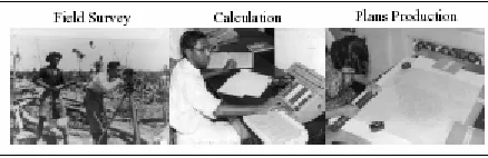
calculator is used. All calculations were then recorded in Calculation Volume (CV). The
last output would be the hand-drawn Certified Plan (CP). Cadastral survey workflows
Figure 2.3: Cadastral survey process before 70’s. (DSMM, 2005)
2.5.2.2 During The 80’s
The DSMM’s modernization programme began in the early 1980’s. Electronic
Distance Measurement (EDM) was introduced eliminating the usage of steel chains and
expecting better accuracy for distance measurement. The trends kept going on until the
introduction of Total Stations in the late 80’s. Although the instrument possessed
elements of automation, surveyors still recorded their data to field books manually due
to unfamiliarity. Yet, programmable electronic calculator was used for calculations
without the reference of cipher book. CALS in 1985 was the first step towards
computerization. Through CALS, digital Calculation Volume (CV) and Certified Plans
(CP) were produced and stored in a database. Figure 2.5 depicts the survey process
during 80’s.
2.5.2.3 During The 90’s
In 1995, Total Stations were used in all District Survey Offices as well as private
survey firm. The survey instruments came with on-board memory, removable
RAM/Data Cards and cadastral on-board software. The integration of Total Station GTS
6A with RAM Card and DCPS 16 (Version 1) software was the first attempt for
“field-to-finish” concept during late 1998 to 1999. The on-board software was programmed for
cadastral title survey, solar observation computation and refixation.
In tandem with District Survey Office Automation System (SAPD), another
configuration was introduced. DCPS16 was substituted by DCPS32 due to
incompatibility with the new system. RAM Card was then realized to have deficiencies
with insufficient storage for crucial cadastral project, on-board ‘C’ and ‘M’ correction.
Consequently, it was replaced by Palmtop such as Jornada 545 and HP 2001x. It is a
small general-purpose, programmable, battery-powered computer capable of handling
both numbers and text, which can be operated comfortably while held in one hand.
Although all data was recorded in memory card, field books were still needed as backup.
The F2F concept has reformed concurrently with the technological enhancement. Many
approaches have been done to fully actualize its F2F concept. The most recent one is the
integration of surveying Total Survey Module (TSM), Tablet PC or Personnel Digital
Assistant (PDA) and GPS Card for reconnaissance and coordinates assumption. While,
Bluetooth enables wireless connection which eliminates cable running between Field
Communicator and Total Station. The original field book has evolved to electronic field
CHAPTER 3
DIGITAL CADASTRAL DATABASE (DCDB)
3.1 Introduction
The DCDB is a spatial representation of the legal land parcel boundaries within South Australia. It comprises approximately 920,000 land parcels, together with their legal identifiers. The DCDB was created to rationalize map based record maintenance within government and provide a single source of up-to-date mapping.
The DCDB also provides a common and spatially consistent boundary framework for client use that promotes consistency among dependent data sets; thus facilitating improved data integration and analysis across government. The DCDB is the fundamental reference layer for spatial information systems in South Australia (Williamson, 1997).
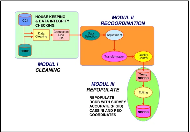
CCI DCDB Data Cleaning Connection Line File Data Selection Adjustment
Transformation ControlQuality
Temp NDCDB
NDCDB Editing
HOUSE KEEPING & DATA INTEGRITY CHECKING
REPOPULATE DCDB WITH SURVEY ACCURATE (RIGID) CASSINI AND RSO COORDINATES MODUL I CLEANING MODUL II RECOORDINATION MODUL III REPOPULATE
enabling cross-referencing to other information needed by. The DCDB is to be based on coordinates determined by ground survey. The storage of data in the DCDB would be in an appropriate form that will allow for easy creation and updating as well as the flexibility of the use of information, including for the creation of mapped products (Ahmad Fauzi, 2001).
Figure 3.1: Flowchart of NDCDB Development
i) Centralized Control
A single Database Management System (DBMS) or GIS under control of one person or group can ensure that data quality standards are maintained, security restrictions are enforced, conflicting requirements are balanced, and the integrity of the data base is maintained.
ii) Data can be shared efficiently
Using a DBMS, the information in a database can be shared in a flexible manner. Also facilitate the development of new applications of the existing database.
iii) Data Independent
Application programs are independent of the physical form in which the data are stored.
iv) Easy implementations of new data base applications.
v) Redundancy can be controlled
A DBMS can be used to monitor and reduce the level of redundancy and multiple copies of data are retained.
vi) User views
A GIS/DBMS can provide a convenient user interface to create and maintain multiple user views.
3.2 Digital Cadastral Database (DCDB)
The DSMM modernisation programme began in the early 1980's. After a successful pilot project in computerizing its cadastral operation in the state of Johor, the initial phase of computerisation exercise was completed in 1995 with the Nationwide implementation of the Computer Assisted Land Survey (CALS) system. The CALS system not only enables electronic processing of cadastral surveys but also introduced the concept of a Digital Cadastral Data Base (DCDB). Eventually, the enhancement process was carried out with the upgrading of the Mini-CALS to the Cadastral Database Management System (CDMS).
The CDMS was established for Quality Assurance of the outsourced data and optimising the performance of the entire system. Apart from that, it was also designed for enhancing the efficiency of the information dissemination mechanism. In short, the main elements of the said system as an addition to the existing Mini-CALS and Mini-CALS (of Johor and Pahang) could be summarised as follows:
(a) Quality Assurance System (QAS) that checks and validate submitted outsourced data, before being posted to the DCDB.
(b) Document Image Management System (DIMS) that creates and manages the library of scanned images of certified plans. This will consequently allow for the supply of CPs in digital form to be made to users.
(c) Counter Service System (CSS), which uses state-of-the-art Information Technology for efficient dissemination of digital spatial data to end-users.
cadastral lots need to be converted into digital form for the creation of the future NDCDB for the whole Peninsular Malaysia.
3.2.1 DCDB Data Structure Overview
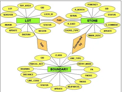
Overview of the DCDB data model are based on model developed by DSMM. We will explain how the DCDB was created in the GIS and DBMS environment. A data model is a formal definition of the data required in a GIS. The data model can take one of several forms namely, a structured list and an entity-relationship diagram. The purpose of the data model, and the process of specifying the model are to ensure that the data has been identified and described in a completely rigorous and unambiguous fashion. The data model will allow the formal specification for the entities, their attributes and all relationships between the entities for the GIS. There are four steps involved in the database development which are external assessment, conceptual modeling, logical design, and physical database.
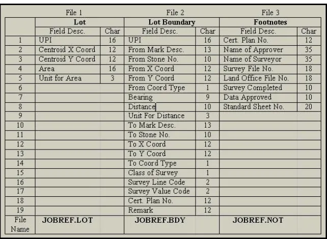
Table 3.1 : DCDB Out-Source Format
DCDB has utilized the relational data base approach for its development. DCDB consists of three main different files or layers which have been presented by three entities such as cadastral lot, boundary mark and boundary stone. All entities are represented by unique spatial object for geographic representation for example polygon for cadastral lot, point for cadastral mark and polyline is used for boundary mark. The design process of DCDB and CCDB consists of five phases as shown in Figure 3.2.
Figure 3.2: The Design Process of DCDB