MULTI-SEQUENCE POSITIONING
ZUHER MESKEN IMBARGK EBRA
A thesis submitted in partial
fulfilment of the requirement for the award of the degree of Master of Electrical Engineering
Faculty of Electrical and Electronic Engineering
Universiti Tun Hussein Onn Malaysia
ABSTRACT
ABSTRAK
Rangkaian sensor tanpa wayar (WSN) telah dianggap sebagai alat yang menjanjikan untuk
banyak lokasi permohonan bergantung seperti pemantauan kawasan, mencari dan
menyelamat, pengesanan mudah alih dan pelayaran, dan lain-lain Selain itu, maklumat
geografi nod sensor boleh menjadi penting untuk meningkatkan pengurusan rangkaian,
perancangan topologi, penghalaan paket dan keselamatan. Walaupun penyetempatan
memainkan peranan yang penting dalam semua sistem-sistem tersebut, itu sendiri adalah
masalah yang mencabar kerana sumber yang sangat terhad di setiap kos rendah nod
sensor. Kajian ini memberi tumpuan kepada menggunakan kaedah anggaran berdasarkan
pengedaran. Sebab untuk memilih kaedah ini kerana ia dianggap sebagai usaha
menjimatkan tenaga berbanding dengan skim penyetempatan berpusat mahal. Skop
anggaran dalam penyetempatan nod sensor adalah kedudukan Multi-Sequence (MSP)
kaedah yang boleh digunakan untuk rangkaian berskala besar bagi mencapai anggaran
jarak yang tepat di dalam pergerakan sensor mana sumber sekiranya mempunyai garis
-sight kepada semua sensor. MATLAB adalah bahasa pengaturcaraan perisytiharan akan
digunakan dalam penyetempatan dan mereka bentuk algoritma kajian. Ini dianggap
sebagai lanjutan daripada rangka kerja pengaturcaraan WSN yang sedia ada. Penilaian ini
dijalankan berdasarkan kesilapan itu adalah akibat daripada senario anggaran lokasi
berbanding dengan teknik penyetempatan semasa Kuat Diterima Isyarat (RSS) dan Masa
Ketibaan (TOA). Hasilnya menunjukkan bahawa MSP menunjukkan lebih cekap dalam
julat pendek dan panjang berbanding TOA. Walau bagaimanapun, RSS terbukti lebih baik
daripada MSP dalam anggaran jarak jauh. Ini telah memberi alasan kepada
langkah-langkah fungsian yang berbeza yang berkaitan di mana RSS biasanya melihat halangan
kurang dan pelindung isyarat satelit manakala MSP boleh dilaksanakan dengan rangkaian
TABLE OF CONTENTS
CHAPTER 1 INTRODUCTION ... 1
1.1 Background of project ... 1
1.2 Research problem ... 3
3.1 The research objectives ... 4
1.4 The contribution of the study ... 4
1.5 The scope study ... 5
1.6 Research overview ... 5
CHAPTER 2 LITERATURE REVIEW ... 7
2.1 Introduction ... 7
2.2 Wireless sensor networks (wsn) ... 8
2.3 Methods of distance estimation in WSN ... 10
2.4 The challenges on distance estimation of nodes in WSN ... 19
2.5 Summary and conclusioin ... 22
CHAPTER 3 RESEARCH METHOD ... 23
3.1 Introduction ... 24
3.2 The method ... 24
3.3 Accuracy measurement ... 29
3.4 Conclusion ... 30
CHAPTER 4 RESULTS AND DISCUSSIONS ... 31
4.1 Introduction ... 31
4.2 MSP location ... 32
4.3 Location estimates from measurements ... 36
4.4 Comparing the performance ... 42
CHAPTER 5 CONCLUSION AND RECOMMENDATION ... 44
5.1 Conclusion ... 44
5.2 Recommendations ... 44
REFERENCES ... 46
LIST OF FIGURES
2.1 The technique of distance estimation of sensor nodes 13
2.2 Distance estimation of sensor nodes method based on (NLOS) and (LOS) 14
3.1 The MSP method flow of distance estimation effort 25
3.2 The flow chart of the localization method is illustrated below 27
3.3 Obtaining Multiple Node Sequences 29
3.4 Layout of the experimental setup 30
4.1 Location of the target and anchor nodes 32
4.2 Target and Anchor Node Locations with Distance Lines 35
4.3 Location estimation for TOA 37
4.4 Location estimation of RSS 37
4.5 Location estimation for RSS at 21 nodes 38
4.6 Location estimation for RSS at 42 nodes 39
4.7 Location estimation for RSS at 05 nodes 39
4.8 RSS and TOA location error measurements 41
4.9 Performance comparison of MSP over TOA and RSS 42
LIST OF TABLES
2.1 Summary of distance estimation methods 15
4.1 D matrix measurements between nodes in MSP 34 4.2 MSP over RSS and TOA location error measurements 40 4.3 Default Simulation Configurations for MSP 41
LIST OF SYMBOLS
WSN Wireless Sensor Networks APS Ad-Hoc Positioning System AOA Angle of Arrival
GPS Global Positioning System
MSPA Matrix Transform-Based Self Positioning Algorithm MDS Multidimensional Scaling
NLOS Non-Line-Of-Sight ROM Read-Only Memory RSS Received Signal Strength
RSSI Received Signal Strength Indicator TOA Time-Of-Arrival
TDOA Time-Difference-Of-Arrival MSP Multi-Sequence Positioning
CHAPTER 1
INTRODUCTION
1.1 BACKGROUND OF PROJECT
A wireless sensor network (WSN) is a group of specialized transducers with a communications infrastructure for monitoring and recording conditions in diverse environment [1]. WSN have seen tremendous advancement in design and applications in the recent years. It involved deployment of huge number of wireless sensor nodes essentially for monitoring a certain area and collecting data [2].
A wireless sensor network of spatially distributed autonomous sensors is used to monitor physical or environmental conditions, such as temperature, sound, pressure, and to cooperatively transmit their data through the network to a main location. The more then networks are bi-directional, also enabling control of sensor activities. The development of WSNs was motivated by military applications such as battlefield surveillance; today such networks are used in many industrial and consumer applications, such as industrial process monitoring and control, machine health monitoring, and so on [3].
information processing. Other applications include habitat monitoring, environmental observation and forecasting systems, health monitoring, etc. In these applications, many low power and inexpensive sensor nodes are deployed in a vast space to cooperate as a network [4].As wireless sensor nodes are battery driven so they have energy constraints too and in this regard the main challenge becomes coverage of the entire area and also ensuring a prolonged network lifetime.
In wireless sensor networks, it is essential for nodes to be aware of their physical positions: firstly, in aforementioned applications, the collected data will be valueless if not associated with corresponding collecting places; secondly, many supporting techniques for wireless sensor networks require nodes knowing their positions, for example, geographic routing, and geographic key distribution [5].
During the past several years, there have been many to turn the vision of sensor networks into a reality. Some prototypes of sensor nodes have been developed, including Motes [6] at Berkeley, u AMPS [7] at MIT, and GNOMES at Rice. The elementary functions of sensor networks include localization, detection, tracking, and targeting. Besides military applications, civilian applications have been developed based on these elementary functions, which can be classified into habitat monitoring, environment observation, health and other commercial applications.
The process in which nodes obtain their positions is called localization. Many localization algorithms have been proposed in the past several years [8] [9] .According to whether precise range measurements (the distances or angels between nodes) can be obtained, these algorithms can be roughly classified into two categories [10]: range-based and range-free. Range-based algorithms usually require some special hardware in order to obtain accurate range measurements between nodes and usually achieve high localization accuracy.
1.2 RESEARCH PROBLEM
The problem of maximizing the network lifetime while satisfying the coverage and also energy constraints [2] represent a big challenge for effective transmission of signals and to fulfill the requirement of sensor network administration. Maintaining energy based on distance estimation is one of the major challenges concerning the design is the power consumption of the wireless sensor node. Low power consumption is mandatory to guarantee a long lifetime if a battery is used as a power source or to allow the use of an energy harvester [12].
Despite the ability of WSN to withstand harsh environmental conditions, the main problems associated with WSN is power consumption for nodes, when in most cases the ineffective distance estimation of sensors increases power consumption of sensors. Though work has been done to resolve this issue but mainly as the problem inherently involves time issues, so the problem formulation is time dependent [13].
Distance estimation is a key issue in range-free localization algorithms for wireless sensor networks. Approaches that assume isotropy of networks, such as Dv-hop and Gradient, cannot obtain accurate distance estimations in anisotropic sensor networks thus are not applicable to such networks [14]. Location and internodes distance estimation is of profound importance for various WSN applications. Similarly, estimation of the hop distance between two network locations is equivalent to estimating the minimum number of hops, which leads to maximization of the distance covered in multihop paths [15].
Based on the above, it is shown that less effort have been made by previous researchers to conceive energy saving protocols and algorithms and improve power sensitive network architectures by applying accurate distance estimation through low energy effort. Therefore, the researcher argues that currently the transmission of signals in WSN though the implementation of distance estimation technique is not effective to minimize the energy consumption in WSN. There may be some effect of shadowing and may results in packet loss, then proper mitigation or corrective measure must be followed in order to accurately measure distance through low energy effort [14].
the remaining distance to the destination in each hop, where some scholars argue this approach is still not a good solution for this problem [2].
Other approaches such as sensors anchor supervised distance estimation in anisotropic wireless sensor networks [14],Connectivity-Based Distance Estimation in Wireless Sensor Networks [16], are considered unreliable approaches to accurate estimate the distance between nodes in WSN. However, the researcher suggest that all these efforts for distance estimations were not effective to reduce power consumption and to the minimum of sensors in WSN. Also there no one combined technique for localization of sensor uses the measurement of the strength (RSS) and the time of arrival (TOA) of the received signal in one protocol, which will be proposed in this study.
1.3 THE RESEARCH OBJECTIVES
1. To investigate distance estimation algorithms based on previous effort through distribution-based estimation schemes.
2. To examine the current sensor localization algorithms used to determine sensors’ positions in wireless sensor networks.
3. To evaluate the proposed algorithms using the current localization technique in WSN those are based on the measurement of the strength (RSS) and the time of arrival (TOA) of the received signal.
1.4 THE CONTRIBUTION OF THE STUDY
1.5 THE SCOPE STUDY
This study is focusing on using a distribution-based estimation method. The reason for selecting this method because it is considered an energy saving effort comparing to costly centralized localization scheme. The scope of the estimation in localization of sensor nodes is a Multi-Sequence Positioning (MSP) method that can be applied for a large-scale network in order to achieve accurate distance estimation in sensor deployments where the source of event has a line-of-sight to all sensors. The MATLAB is a declarative programming language will be used in the localization and designing the algorithm of the study. This is conceived as an extension of existing WSN programming frameworks.
1.6 RESEARCH OVERVIEW
The research is divided into five chapters as follow:
Chapter 1: The introduction of the thesis, which includes the introduction on the topic, the problem statement, the research questions and objectives, and research contribution. Chapter 2: Presenting the necessary background information and related research for accurate sensor distance estimation algorithms in wireless sensor networks. The challenges for effective and robust sensor localization are also discussed.
The researcher proposes the concept of distance estimation in sensor networks. The application demands for differentiated sensor distance estimation are identified. Then, three differentiated sensor distance estimation methods based on multidimensional scaling techniques are proposed to get accurate position estimation and to reduce computation and communication costs that save energy efforts in WSN.
Chapter 3: The research methodology. The researcher proposes the methods and algorithms used accurate distance estimation in WSN.
adjacent sensors. The estimated positions of the anchors are compared with their true physical positions and corrected to achieve robust sensor localization.
CHAPTER 2
LITERATURE REVIEW
2.1 INTRODUCTION
2.2 WIRELESS SENSOR NETWORKS (WSN)
A wireless sensor network (WSN) is a computer network composed of sensor nodes distributed in different locations in a certain area for a specific purpose by transmitting wireless signals to the administration center. The sensors in WSN used in an infrastructure-based (base stations) or in a self organizing ad-hoc network in order to send specific information and required data for particular aim on their environment using sensors [17].
Wireless Sensor Network (WSN) is typically a sub-class of ad hoc networks. It is a network of sensors in order to monitor some phenomenon. This network of sensors has wide application in hard to reach places or hazardous areas, such as in the following areas [18]:
Military - monitoring functions, tracking, security, control and maintenance;
Industrial monitoring functions, particularly in areas of difficult access;
Aviation - replacing wired networks, as they are already used today;
Environment - monitoring environmental variables in buildings, oceans forests, etc; Traffic - monitoring of roads, parking lots, etc;
Engineering - monitoring (and modeling) structures.
Recent years have witnessed great advances in using WSN and embedded sensors. Wireless sensor nodes are typically integrate many great features such as small devices, low-power, low-cost, equipped with limited sensing, data processing and wireless communication capabilities, as well as power supply. Sensor Networks create exciting opportunities for large-scale, data-intensive measurement, surveillance, and analytical applications [19].
Beyond military applications, sensor nodes have interesting civilian uses as illustrated below [21]:
Energy efficiency: Red sensors are used to monitor the efficient use of electricity,
as the case of Japan and Spain.
High security environments: There are places that require high levels of security
to prevent terrorist attacks such as nuclear power plants, airports, government buildings restricted passage. Here thanks to a network of sensors can detect situations with a simple camera would be impossible.
Environmental sensors: Environmental control of vast areas of forest or ocean,
would be impossible without sensor networks. The control of multiple variables such as temperature, moisture, fire, earthquakes and other. They also help experts diagnose or prevent a problem or urgency and minimize the environmental impact of human presence. Industrial sensors: Within factories complex systems there are quality control,
the size of these sensors allows them to be where required.
Automotive: Sensor networks are the ideal traffic cameras because they can
inform the traffic situation in blind spots that do not cover cameras and can also inform drivers of the situation, should complement jam or accident, with what they have resilience to take alternative routes.
Medicine: Another very promising field. With the downsizing that are
experiencing the sensor nodes, the quality of life of patients who have to be checked his vital signs (pulse, pressure, blood sugar level, etc), you can improve substantially. Automation: Their size, economy and speed of deployment, make it an ideal
home technology at an affordable price.
Based on the above, the research summarizes the main characteristics of wireless sensor network:
Energy consumption restrictions for sensor nodes using short life batteries
or constraints on power consumption.
Difficulty for accurate distance estimation and exact localization Capability to deal with node failures
Heterogeneousness of nodes Mobility of sensor nodes
Scalability. Most of wireless sensor networks are installed in a large scale
of deployment.
Ability to withstand harsh environmental conditions Ease of use
Cross-layer design
2.3 METHODS OF DISTANCE ESTIMATION IN WSN
Usually wireless sensor networks comprised of hundreds to thousands of cheap nodes with inhibited computing power and limited memory, where the short battery lifetime is the main obstacle in distance estimation of nodes. Even sensors are the most efficient ways nowadays for monitoring of areas and collecting essential data for particular purposes [23]. Localization is a very important issue for various sensor applications, and the accuracy of distance estimation should be high and localization must be low cost in wireless sensor networks. Besides distance estimation is vital for sensor network management such as topology control, boundary detection and so on [24].
The main purpose of sensor localization and estimation of distances between the nodes is to determine the location of sensors in a WSN via noisy measurements. The main measurements used for distance estimation include the following:
1. Received Signal Strength (RSS) 2. Time-of-Arrival (TOA)
The researcher argue that RSS currently is a popular method and most used in distance estimation mainly because of its low complexity and higher efficiency comparing to other methods and also considering the cost in software and hardware implementations, RSS in the best method in this distance measurement.
The estimation of distance of nodes in wireless sensor network is usually based on radio frequency techniques, which is based on measuring certain parameters of radio signal which is received by one node from other nodes, some of these parameters are very important for distance estimation such as the angle of arrival (AOA), The time of arrival (TOA), The received signal strength (RSS) [25].
There are great efforts by researchers and scholars in this topic and many researchers have developed special localization algorithms to enhance the accuracy of specifying the position of nodes sending the necessary data, including distance-based algorithms and connectivity-based algorithms [26]:
1. A distance-based localization algorithm is basically rely on measuring the distance and estimates the distance between nodes in WSN. This algorithm can achieve good results and high localization accuracy; where in most of cases the distance estimation are either unavailable or comes with huge errors.
2. Connectivity-based localization algorithm is a reliable algorithm for rough- grained areas that needs for high localization accuracy.
The distance estimation can be realized by using information such as received signal strength (RSS) and time of arrival (TOA).
RSS is defined as a voltage measured by a receiver’s received signal strength indicator (RSSI) circuit. Often, RSS is equivalently reported as a measured power. Wireless sensor nodes communicate with their neighboring sensors, so the RSS of the transmitted signals can be measured by each receiver during common communication without presenting additional bandwidth or energy requirements [27].
most importantly, multipath effect [28]. The multipath effect causing an existence of fading points is often difficult to predict or mitigate. Furthermore the multipath effect is expected to be significantly stronger indoor than outdoor [26]. Most of the RSS-based methods require a relationship between the distance and the received power to estimate the position of unknown devices time difference of arrival (TDOA) [26].
The RSS method (using RSS measurements) depends on low-cost hardware and only provides coarse-grained distance estimates: by contrast, the TOA and TDOA methods can provide distance estimates with higher accuracies at the cost of extra hardware. Due to cost constraints, it is impractical to equip all sensors in a large-scale sensor network with extra hardware to obtain accurate distance estimates and thus accurate location estimates [9]. Although a number of onnectivity-based localization algorithms have been proposed, see e.g. achieving high localization accuracy usually demands a comparatively large number of anchor nodes, hereafter termed simply anchors, whose positions are known a priori (accordingly, we term other nodes whose positions are not known and need to be determined as sensors). Therefore. It is attractive to develop low-cost distance estimation methods with comparatively good accuracies. In this paper, we shall propose such a method which does not rely on extra hardware but provides comparatively accurate distance estimates [29].
Figure 2.1: The technique of distance estimation of sensor nodes [27]
Figure 2.2: Distance estimation of sensor nodes method based on non-line- of-sight (NLOS) and line-of-sight (LOS) [27]
Moreover, the probability of incorrect identification is always non-negligible in this scenario. It is possible that a LOS connection is misidentified as a NLOS connection (false alarm) or vice versa (missed detection) which might significantly decrease estimation accuracy. Third, the estimator knows neither which connections are NLOS nor their distribution. The optimal accuracy is hard to define in this scenario, since it is difficult to distinguish NLOS connections. Robust estimators are such as the M-estimator and least median of squares (LMS) algorithm [30].
Emphasizes on the importance of the following three protocols for distance estimation [31]:
Beacon Protocol. In beacon protocol, anchor node initiates the
Continuous Ranging Protocol. In continuous ranging protocol,
unlocalized node starts localization process, and its drawback is that unlocalized node sends range message even if localization wave still does not arrive.
Optimized Beacon Protocol. Optimized beacon protocol is the same as
beacon protocol in which anchor nodes send range messages. However, when unlocalized node overhears three range messages, it starts localization process without waiting for neighbor node. When unlocalized node becomes localized node, it can localize other nodes as well.
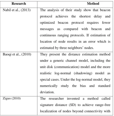
[image:23.612.164.537.337.718.2]In the following table, the researcher summarizes methods used by scholars on distance estimation of sensor nodes localization.
Table 2.1: Summary of distance estimation methods
Research Method
Nabil et al., (2013) The analysis of their study show that beacon protocol achieves the shortest delay and optimized beacon protocol requires fewer messages as compared with beacon and continuous ranging protocols. If estimation of location of node results in an error which is estimated by three neighbors’ nodes.
Baoqi et al., (2010) They present the distance estimation method under a generic channel model, including the unit disk (communication) model and the more realistic log-normal (shadowing) model as special cases. Under the log-normal model, they numerically study the bias and standard deviation.
sub-hop resolution. He fined that although radio signal strength (RSS) is considered irregular in many situations due to the unknown radio propagation loss.
Whitehouse (2009) The results of his empirical study shows that in outdoor open-air scenario, radio signal strength weakens approximately monotonically with the physical distance (in a statistic sense), especially from the viewpoint of a single node.
Xiang Ji (2004) They propose three sensor localization algorithms based on the multidimensional scaling techniques. They include a centralized sensor localization algorithm, a distributed sensor localization algorithm, and a robust sensor location algorithm based on multidimensional scaling.
Lei and Qingzheng (2010)
They develop a standardized clustering-based approach for the local coordinate system formation wherein a multiplication factor is introduced to regulate the number of master and slave nodes and the degree of connectivity among master nodes. Second, using homogeneous coordinates, they derive a transformation matrix between two Cartesian coordinate systems to efficiently merge them into a global coordinate system and effectively overcome the flip ambiguity problem.
This Study
single algorithm. This study will use a distribution-based estimation method in order to reduce cost of localization comparing to costly centralized localization scheme. The estimation method is called Multi-Sequence Positioning (MSP) method that can be applied for a large-scale networks in order to achieve accurate distance estimation in sensor nodes deployment where the source of event has a line-of-sight to all sensors.
Argues that the activities have to be optimized is the placement of the nodes are based on knowledge of the user's location or other surrounding objects to provide services and information that is useful and effective [32]. Furthermore, the identification of the correct position of the nodes can be used to optimize aspects of networks and services such as routing [33], then it will be the maximum energy saving.
Suggest that wireless devices in most of times have limited energy resources such as batteries [33]. Therefore, the sensors in WSN should be efficiently managed by selecting the right position depending on various factors that enhance the effort of energy saving and extend the lifetime of the network and the overall efficiency of the wireless network.
In the same context conclude that the approaches that use dedicated hardware are not efficient anymore, not effective for right localization of nodes and cannot be reliable in commercial off-the-shelf systems [34].
On the other hand, some scholars found that the radio system is the most part in wireless node that consumes energy, whereas other parts in the node such as the processor, and memory consume less power. Therefore any solutions includes the reduction of the complexity of algorithms associated with localization of nodes will not significantly reduce energy consumption significantly [35] [27].
accuracy and better estimation of nodes’ positions should be considered as one of the main factors that increase energy consumption.
Indicate that the estimated distance of nodes is essential for locating the needed sensors and many other applications in wireless sensor networks [16]. In their study they developed a method that employs the maximum likelihood estimation (MLE) which is used to estimate the distances between a pair of neighboring nodes in static wireless sensor network, and using their information in local connectivity, i.e the numbers a non-common and non-common jump neighbors. They present the distance method estimation under a generic channel model, include the disk drive model (communication) and a more realistic log-normal model (shading) in special cases. According to the log-normal model, they numerically study the bias and standard deviation associated with their method and show long outperforms based on the received signal strength (RSS). Finally, the application of their proposed method is based on the actual measurement data and connectivity of sensor-based localization, and the superiority of the proposed method approved.
It can be concludes that the above findings by previous studies show that it could be highly probable to increase energy consumption if the distances between the nodes were not estimated properly.
process is controlled by MAC layer .The principle of TWR to calculate different time stamps between two nodes is presented in the following equation [40].
𝐷𝐴,𝐵 = V(𝑡4− 𝑡1) − (𝑡3− 𝑡2)
2
𝐷𝐴,𝐵 = 𝑉(𝑡4− 𝑡1) − (𝑡3 − 𝑡2)
Where V is the speed of light (radio signals), 𝑡4and 𝑡2 are reception instants, and 𝑡1 and
𝑡3 are emission instants. Clock synchronization is not a problem in this technique because
each node has its own local clock and time stamps are calculated on these local clocks. When distance is measured by this formula, relatively accurate location can be estimated. Several authors proposed different protocols to analyze convergence speed and
evaluate the communication cost related to energy. Different mechanisms are used to address some important issues such as the convergence conditions to achieve network wide localization, beginning and termination of the location propagation process, advantage of the broadcast nature of radio communications, and cooperation of nodes to reduce the number of exchanged messages and so energy consumption.
TWR has some issues such as clock drift in cheap sensor nodes, different response delays of nodes, and channel impairments.
2.4 THE CHALLENGES ON DISTANCE ESTIMATION OF NODES IN WSN
One major challenge in a WSN is to produce low cost and tiny sensor nodes. There are an increasing number of small companies producing WSN hardware and the commercial situation can be compared to home computing in the 1970s. Many of the nodes are still in the research and development stage, particularly their software. Also inherent to sensor network adoption is the use of very low power methods for radio communication and data acquisition [41].
In many applications, a WSN communicates with a Local Area Network or Wide
resources, for example, in a remotely located server [42].List the major difficulties that challenge accurate and efficient positioning of sensor nodes in wireless sensor networks in the following [43]:
Cost and energy constraints for every sensor node. The demand for a
low-energy and low-cost and the design at each node in WSN disallow accurate localization with hardware support. For example GPS [44], which is the most widely used technique in localization, can hardly be applicable for every sensor node in the network. Similarly, extra ranging modules, such as directional antennas, electronic compass, laser rangers, video cameras, etc, are severely limited due to their incompatible size, considerable cost or excessive power consumption [45].
The scale of the Network. A wide scale wireless sensor network could
potentially be a big challenge for energy saving and accurate estimation of proper distance between the nodes. In many cases wireless sensor network composed of a large number of nodes [6], [46]. It is also expected that future wireless sensor networks may include hundreds thousands or even multi millions of nodes [47] [34] which bear a great challenge to efforts for energy saving.
Severe working environments. Wireless sensor networks in many cases
are installed in harsh environment and in randomly deployed areas where the access to the land is very difficult and environment is not easy, such as conflict zones and battle field). In this case, self-organized localization without close-in human interference and calibration is essential [48].
Cross-layer is becoming an important studying area for wireless communications. In addition, the traditional layered approach presents three main problems [1]:
1. Traditional layered approach cannot share different information among different layers which leads to each layer not having complete information. The traditional layered approach cannot guarantee the optimization of the entire network.
3. Because of the interference between the different users, access confliction, fading, and the change of environment in the wireless sensor networks, traditional layered approach for wired networks is not applicable to wireless networks.
Argue that the estimation the distance of sensor nodes have many questions[49], and to
solve the scientific community is trying to interesting research field WSN localization and have still plenty of spaces for new researchers such as the following:
1. The design of the founder of the localization algorithm should be cost-effective, better distribution and localization algorithm.
2. The estimation position of sensor nodes is not appropriate using GPS, because it is not cheaper and not efficient energy technique, these are with a large number of hardware, and has a direct line of sight subject. If the GPS is installed at each intersection, then increases the size and cost of power distribution units. In addition, GPS is not energy efficient, much power consumption and is not suitable for network like WSN.
3. Based localization system for real design WSN work than other networks. How in WSNs, it is important to take into account all the constraints, for example, bass processor, limited memory, small data transfer speed and size.
4. The expectations of localization problem programs can lead to mistakes. 5. The accuracy is a very important factor to locate all nodes, if the estimated location of the node. When local node that coordinates misinformation and spread incorrect data.
6. The node density is an important factor in the development of localization algorithm. The distance estimation algorithm should be accurate with fewer number of beacon nodes.
2.5 SUMMARY AND CONCLUSIOIN
Wireless sensor networks have many applications in which sensor nodes collect data from particular location and process it. However, it is an important task into consideration the location of data sending or the location of sensor transmitting the data. Localization and distance estimation is the most important task in WSN and defined in this study as the mechanism for locating nodes in WSN. There are many approaches for localization and accurate estimation of distance; however, such approaches are desirable which are capable to deal with limited resources in the wireless network.
The previous studies show the importance of distance estimation to sensor nodes and
the needed accuracy to save cost and time for locating the sensor. Many scholars emphasizes that practical and effective solutions are required to perform the accurate localization in the efforts for an energy-efficient method.
The researcher suggest that the current methods for distance estimation and distance
measurements such as RSS and TAO can be used for effective distance estimation but require further development to increase the accuracy in WSN and locate the right position nodes in WSN that can be used in energy-efficient algorithm. The researcher suggests these two methods can be used together and comparing their parameters with previous data saved in WSN database.
Based on previous studies, the challenges on accurate node positioning indicates that a solution designed for localization must be a sensor node friendly solution, where ensuring essential features such as energy efficient, short time, and low-cost, all these features of algorithms and techniques used for distance estimation efforts are assumed necessary.
The challenges on accurate node positioning indicates that a localization solution
must be sensor node friendly, where features of low-cost, energy efficient, and small footprint are necessary.
measure the exact parameter for the localization (e.g., RSS, TOA) and the energy consuming should be kept to the minimum. In addition to that a localization design must be network scalable, meaning that it should be cost-effective with both small and large scale systems.
Furthermore, it is found that previous studies proposed two types of cooperative
CHAPTER 3
RESEARCH METHOD
3.1 INTRODUCTION
In this chapter introduces the methods that will be used for the analysis of data and accurately estimation of sensor node distance in localization task. The steps of the localization method will be introduced based on multi-sequence positioning and sensor nodes detection of event in sequential manner and synchronously.
3.2 THE METHOD
This study will use a distribution-based estimation method because it is energy saving effort comparing to costly centralized localization scheme. The estimation method is called Multi-Sequence Positioning (MSP) method that can be applied for a large-scale network in order to achieve accurate distance estimation in sensor deployments where the source of event has a line-of-sight to all sensors [43].
The basic operation of MSP is by extracting the relative information of sensor node
REFERENCES
[1] Muaz Niazi, Amir Hussain (2011). A Novel Agent-Based Simulation Framework for Sensing in Complex Adaptive Environments. IEEE Sensors Journal, Vol.11 No. 2, 404–412. Paper
[2] S , Tanvir ., Jabeen, F., Khan, M. I., & Ponsard, B. (2012). On propagation properties of beacon based localization protocol for wireless sensor networks .Middle-East Journal of Scientific Research, 12(2), 131-140.
[3] Shang Y, Ruml W, Zhang Y, and Fromherz MPJ. Localization from mere connectivity. In Proc. of the ACM MobiHoc, pages 201–212, Annapolis, Maryland, USA, Jun. 2003.
[4] Pieter DeMil, Bart Jooris, Lieven Tytgat, RubenCatteeuw, Ingrid Moerman, Piet Demeester, and AdKamerman.2010. “Design and Implementation of a Generic
Energy-Harvesting Framework Applied to the Evaluation of a Large-Scale Electronic Shelf-Labeling Wireless Sensor Network “. Hindawi Publishing Corporation EURASIP Journal on Wireless Communications and Networking Volume 2010, Article ID 343690.
[5] Benbadis, F., Friedman, T., de Amorim, M. D., Fdida, S. 2005. “GPS-free positioning system for wireless sensor networks”. In Proceedings of the 2nd IFIP
International Conference on Wireless and Optical Communications Networks (WOCN ’05), Mar., pp. 541-
[6] J. Hill and D. Culler. A 2002.wireless embedded sensor architecture for system-level optimization. In UC Berkeley Technical Report,.
[7] Wendi B. Heinzelman, Member, IEEE, Anantha P. Chandrakasan, Senior Member, IEEE, and Hari Balakrishnan, Member, IEEE TRANSACTIONS ON WIRELESS COMMUNICATIONS, VOL. 1, NO. 4, OCTOBER 2002.
[8] Gu, Y., Ji, Y., Li, J., & Zhao, B. (2009, November). Fundamental results on target coverage problem in wireless sensor networks. In Global Telecommunications
[9] Saptarshi Chaudhuri ,. (2011). Greedy Algorithms for Target Coverage Problem in Wireless Sensor Networks (Doctoral dissertation).
[10] Tarrío, P., Bernardos, A. M., & Casar, J. R. (2011). Weighted least squares techniques for improved received signal strength based localization. Sensors,11(9), 8569-8592.
[11] Paula Tarrío, Ana M. Bernardos, and José R. Casar. 2012. “An Energy-Efficient Strategy for Accurate Distance Estimation in Wireless Sensor Networks”. Sensors
(Basel). 2012; 12(11): 15438–15466. PMCID: PMC3522971
[12] H. Lim and J.C. Hou. 2005. “Localization for anisotropic sensor networks”. In Proc. of 24th Annual Joint Conference of the IEEE Computer and Communications Societies(INFOCOM 2005), pages 138–149, 2005.
[13] Guanhua Chen, Xiuli Ma, Dongqing Yang, Shiwei Tang, Shuai Meng. Mining Representative Subspace Clusters in High-Dimensional Data. Accepted by FSKD 2009.
[14] Xu Y., Winter J., Lee W. 2004. “Prediction-based Strategies for Energy Saving in Object Tracking Sensor Networks”. Proceedings of the IEEE International
Conference on Mobile Data Management; Berkeley, CA, USA. 19–22 January 2004; pp. 346–357.
[15] Anto Gracious, L.A. ; Subbulakshmi, T.C. 2011. “Emerging Trends in Electrical and Computer Technology (ICETECT)”. International Conference on in
Electrical and Computer Technology. IEEE DOI: 10.1109/GLOCOM.2010.5683252
[16] Anto Gracious, L. A., & Subbulakshmi, T. C. (2011, March). Multihop distance estimation with Greedy approach in wireless sensor networks. In Emerging Trends in Electrical and Computer Technology (ICETECT), 2011 International Conference on (pp. 901-905). IEEE.
[17] Dargie, W. W., & Poellabauer, C. (2010). Fundamentals of wireless sensor networks: theory and practice. John Wiley & Sons.
[19] Gezici S. A survey on wireless position estimation. Wirel. Pers. Commun. 2008;44:263–282.
[20] Warneke, B., Scott, M. D., Leibowitz, B. S., Zhou, L., Bellew, C. L., Chediak, J. A., ... & Pister, K. S. (2002). An autonomous 16 mm 3 solar-powered node for distributed wireless sensor networks. In Sensors, 2002. Proceedings of IEEE (Vol. 2, pp. 1510-1515). IEEE.
[22] Matischek, R. (2012). Real-Time Communication MAC Protocols for Wireless Sensor Networks.
[23] Silva, D.; Ghanem, M.; Guo, Y. (2012). "WikiSensing: An Online Collaborative Approach for Sensor Data Management". Sensors 12 (12): 13295
[24] Sitanayah, L., Datta, A., & Cardell-Oliver, R. (2010). Heuristic algorithm for finding boundary cycles in location-free low density wireless sensor networks.Computer Networks, 54(10), 1630-1645.
[25] Sohraby, K., Minoli, D., & Znati. (2007). Wireless sensor networks: technology, protocols, and applications. John Wiley & Sons.
[26] Liu, B. C., Lin, K. H., & Wu, J. C. (2006). Analysis of hyperbolic and circular positioning algorithms using stationary signal-strength-difference measurements in wireless communications. Vehicular Technology, IEEE Transactions on, 55(2), 499-509.
[27] Pasupuleti, H., Rao, R., Selvakumar, D., & Reddy, S. R. K. (2012, December). Energy aware self powered wireless sensor mote. In Sensing Technology (ICST), 2012 Sixth International Conference on (pp. 630-636). IEEE.
[28] Li, L., Halpern, J. Y., Bahl, P., Wang, Y. M., & Wattenhofer, R. (2005). A cone-based distributed topology-control algorithm for wireless multi-hop networks.Networking, IEEE/ACM Transactions on, 13(1), 147-159.
[29] Brad Karp and H. T. Kung. 2000. “Gpsr: Greedy perimeter stateless routing for wireless networks”. In Proceedings of the 6th Annual International Conference on Mobile Computing and Networking (Mobicom’00), pages 243–254, Boston,
[30] Gandhi, S., Suri, S., and Welzl, E. “Catching elephants with mice: Sparse sampling for monitoring sensor networks”. ACM Transactions on Sensor Networks, vol. 6,
no. 1,
[31] Nabil Ali Alrajeh ,Maryam Bashir, & Bilal Shams. (2013). Localization techniques in wireless sensor networks. International Journal of Distributed Sensor Networks,2013. Article ID 304628, 9 pages.
[32] Stojmenovic, I. (2002). Position-based routing in ad hoc networks. Communications Magazine, IEEE, 40(7), 128-134.
[33] Yick, J., Mukherjee, B., & Ghosal,. (2008). Wireless sensor network survey.Computer networks, 52(12), 2292-2330.
[34] Karalar, T. C., Yamashita, S., Sheets, M., & Rabaey, J. (2004, October). A low power localization architecture and system for wireless sensor networks. InSignal Processing Systems, 2004. SIPS 2004. IEEE Workshop on (pp. 89-94). IEEE. [35] Anastasi G., Conti M., Di Francesco M., Passarella A.)2009). Energy conservation
in wireless sensor networks: A survey. Ad Hoc Netw.;7:537–568.
[36] Whitehouse, K., Karlof, C., Woo, A., Jiang, F., and Culler, D. 2009. “The effects of ranging noise on multihope localization: an empirical study".
[37] Tian , He ., Huang, C., Blum, B. M., Stankovic, J. A., & Abdelzaher, T. (2003, September). Range-free localization schemes for large scale sensor networks. In Proceedings of the 9th annual international conference on Mobile computing and networking (pp. 81-95). ACM.
[38] Li, X. (2006). RSS-based location estimation with unknown pathloss model.Wireless Communications, IEEE Transactions on, 5(12), 3626-3633.
[39] C, Alippi, & Galperti, C. (2008). An adaptive system for optimal solar energy harvesting in wireless sensor network nodes. Circuits and Systems I: Regular Papers, IEEE Transactions on, 55(6), 1742-1750.
[41] S. Qureshi , Asar, A., Rehman, A., & Baseer, A. (2011). Swarm intelligence based detection of malicious beacon node for secure localization in wireless sensor networks. Journal of Emerging Trends in Engineering and Applied Sciences (JETEAS), 2(4), 664-672.
[42] Milenkovic, M., & Amft, O. (2013, January). An opportunistic activity-sensing approach to save energy in office buildings. In Proceedings of the fourth international conference on Future energy systems (pp. 247-258). ACM.
[43] Zhong, Z. (2010). Range-free localization and tracking in wireless sensor networks (Doctoral dissertation, University of Minnesota). For The Degree of PHD degree.
[44] Baoqi Huang ; Changbin Yu ; Anderson, B.D.O. ; Guoqiang Mao. 2010. “Connectivity-Based Distance Estimation in Wireless Sensor Networks”. Global
Telecommunications Conference (GLOBECOM 2010). IEEE DOI: 10.1109/GLOCOM.2010.5683252
[45] Siripongwutikorn, P., & Thipakorn, B. (2008). Mobility-aware topology control in mobile ad hoc networks. Computer Communications, 31(14), 3521-3532. [46] Akyildiz, I. F., Su, W., Sankarasubramaniam, Y., & Cayirci, E. (2002). A survey
on sensor networks. Communications magazine, IEEE, 40(8), 102-114.
[47] Mi, Q., Stankovic, J. A., & Stoleru, R. (2010, March). Secure walking gps: A secure localization and key distribution scheme for wireless sensor networks. In Proceedings of the third ACM conference on Wireless network security (pp. 163-168). ACM.
[48] E. Kim & Kim, K. (2010). Distance estimation with weighted least squares for mobile beacon-based localization in wireless sensor networks. Signal Processing Letters, IEEE, 17(6), 559-562.
[49] Culler, D., Estrin, D., & Srivastava, M. (2004). Guest editors' introduction: overview of sensor networks. Computer, 37(8), 41-49.
[51] U. Kubach and K. Rothermel (2001), "Exploiting location information for infostation-based hoarding," in Proceedings of the 7th annual international conference on Mobile computing and networking, , pp. 15-27.
[52] H. Celebi and H. Arslan (2007), "Utilization of location information in cognitive wireless networks," Wireless Communications, IEEE, vol. 14, pp. 6-13,.
[53] K. Chintalapudi, A. Padmanabha Iyer, and V. N. Padmanabhan (2010), "Indoor localization without the pain," in Proceedings of the sixteenth annual international conference on Mobile computing and networking, , pp. 173-184. [54] I. Nonaka (1994), "A dynamic theory of organizational knowledge creation,"
Organization science, vol. 5, pp. 14-37,.
![Figure 2.1: The technique of distance estimation of sensor nodes [27]](https://thumb-us.123doks.com/thumbv2/123dok_us/8763528.895192/21.612.216.470.73.327/figure-technique-distance-estimation-sensor-nodes.webp)
![Figure 2.2: Distance estimation of sensor nodes method based on non-line- of-sight (NLOS) and line-of-sight (LOS) [27]](https://thumb-us.123doks.com/thumbv2/123dok_us/8763528.895192/22.612.229.462.74.327/figure-distance-estimation-sensor-nodes-method-based-sight.webp)