Building Geospatial Ontologies from Geographic Database
Schemas in Peer Data Management Systems
Danúbia Lima1, Antonio Mendonça1, Ana Carolina Salgado2, Damires Souza1
1 Federal Institute of Education, Science and Technology of Paraiba, Brazil 2 Federal University of Pernambuco, Brazil
{[email protected], [email protected], [email protected], [email protected]}
Abstract. One key issue in Peer Data Management Systems (PDMSs) is the heterogeneity of the peer schemas. To help matters, ontologies may be used as uniform conceptual representation of these schemas. In this work, we are working with geographic databases to be used in a PDMS. When dealing with geospatial data, specific problems with representation and usage occur. In this sense, we have developed an approach and a tool, named GeoMap, which builds a peer ontology from a geographic database schema. In order to provide geospatial semantics when mapping, we have defined and used a reference geospatial ontology. We present the principles underlying our approach and examples illustrating how they work by means of the tool.
1. Introduction
Peer Data Management Systems (PDMSs) came into the focus of research as a natural extension to distributed databases in the peer-to-peer (P2P) setting [Lodi et al. 2008, Sung et al. 2005]. PDMSs are considered the result of blending the benefits of P2P networks, such as lack of a centralized control, with the richer semantics of a database [Zhao 2006]. They can be used for data exchanging, query answering and information sharing. For instance, in the areas of scientific research, the idea of setting up a PDMS to share research data among peers has already been widely discussed [Lodi et al. 2008, Zhao 2006].
A PDMS consists of a set of inter-related peers (data sources). Each peer has an associated schema within a domain of interest. However, PDMSs do not consider a single global schema. Instead, each peer represents an autonomous data source and exports either its entire data schema or a portion of it. Such schema, named exported schema, represents the data to be shared with the other peers of the system.
Data management in PDMSs is a challenging problem given the heterogeneity of their schemas. Due to the fact that ontologies provide good support for understanding the meaning of data, they have been used as an uniform metadata representation, i.e., each data source schema is represented by a local ontology (named peer ontology) [Souza et al. 2011, Xiao 2006]. In addition, due to semantic heterogeneity, research on PDMSs has also considered the use of ontologies as a way of providing a domain reference [Souza et al. 2011, Xiao 2006]. Considering a given knowledge domain, an agreement on its terminology can occur through the definition of a domain ontology which can be used as a semantic reference or background knowledge to enhance processes such as ontology matching and query answering.
One of the most representative realms of diversity of data representation is the geospatial domain. Geospatial data, besides hierarchical and descriptive components (relationships and attributes), are featured by other ones such as geometry, geospatial location and capability of holding spatial relationships (e.g., topological) [Hess 2008, Fonseca et al. 2003]. Furthermore, geospatial data are often described according to multiple perceptions, different terms and with different levels of detail. Syntactical aspects have been addressed by interoperability standards, such as Geography Markup Language [GML 2007]. However, the most hard-facing problem is still concerned with semantic heterogeneity.
In this work, we are working with geographic databases to be used in a PDMS called SPEED (Semantic PEEr-to-Peer Data Management System) [Pires 2009]. In order to uniformly deal with geospatial data without worrying about their specific heterogeneity restrictions (syntactic or semantic), we use ontologies as uniform conceptual representation of peer schemas. When a peer asks to enter the system, its schema (e.g., represented according to the relational or object-relational database model) must be automatically exported to a peer ontology. Due to the special semantics of geospatial data, this automatic extraction becomes more complex. Thus, in this work, we present an approach and an implemented tool, named GeoMap, for automatically building a geospatial peer ontology as a semantic view of data stored in a geographic database. During the ontology building process, a set of correspondences (relationships) between the generated ontology components and the original database schema is also automatically generated. The produced peer ontology will be later used for matching and querying processes in the PDMS. The set of correspondences will be used to translate ontological queries into the database query language (e.g., SQL) and retrieve corresponding instances from the geographic databases.
This paper is organized as follows: Section 2 introduces the SPEED system;; Section 3 presents the GeoMap approach;; Section 4 describes the developed GeoMap tool with some peer ontology generation examples. Related work is discussed in Section 5. Finally, Section 6 draws our conclusions and points out some future work.
2. The SPEED System
The SPEED system is a PDMS which works with three distinct types of peers, namely: data peers, integration peers, and semantic peers. A data peer represents a data source sharing structured or semi-structured data with other data peers in the system. Data peers are grouped within semantic clusters according to their semantic interest. A
VHPDQWLF LQWHUHVW LQFOXGHV WKH SHHU¶V LQWHUHVW WKHPH DQG D ORFDO SHHU RQWRORJ\ 7KH LQWHUHVW WKHPH LV DQ DEVWUDFW GHVFULSWLRQ RI WKH SHHU¶V VHPDQWLF GRPDLQ ZKHUHDV WKH
locaOSHHURQWRORJ\/2GHVFULEHVWKHSHHU¶VH[SRUWHGVFKHPD(DFKVHPDQWLFFOXVWHU
has a special type of peer named integration peer. Actually, integration peers are data peers with higher availability, network bandwidth, processing power, and storage capaciW\6XFKSHHUVDUHUHVSRQVLEOHIRUWDVNVOLNHPDQDJLQJGDWDSHHUV¶PHWDGDWDTXHU\
answering, and data integration. An integration peer maintains a cluster ontology (CLO), which is obtained through the merging of the local ontologies representing data
peerV¶DQGLQWHJUDWLRQSHHU¶VH[SRUWHGVFKHPDV,QWHJUDWLRQSHHUVFRPPXQLFDWHZLWK D
semantic peer, which is responsible for storing and offering a community ontology (CMO) containing elements of a particular knowledge domain (i.e., a domain ontology). SemantiF SHHUV DUH UHVSRQVLEOH IRU PDQDJLQJ LQWHJUDWLRQ SHHUV¶ PHWDGDWD $ VHW RI
clusters sharing semantically similar interests composes a semantic community. An overview of the SPEED architecture, with its kinds of peers and used ontologies is presented in Figure 1.
I1D1 I1D2 I1 I2D1 I2D2 I2 BC Community I1D1 I1D2 I1 I2D1 I2D2 I2 Cluster 2 Cluster 1
Cluster Ontology -‐ CLO Local Ontology -‐ LO
Legend:
I1ʹIntegration Peer
I1D1ʹData Peer
Community Ontology -‐ CMO
Figure 1: An Overview of SPEED Architecture
3. The GeoMap Approach
The database-to-ontology mapping approaches are usually classified into two main categories [Ghawi and Cullot 2009]: (i) approaches which create an ontology from a database and, (ii) approaches which map a database to an existing ontology. In the former, the objective is the creation of an ontology from a database and may include both the metadata and the data. The mappings, in this case, are the correspondences between each created ontology component (e.g., concept, property) and its original database schema concept (e.g., table, column). In the latter, the goal is to create a set of mappings between the existing ontology and the database. In our approach, we focus on the former, i.e., we build an ontology from a geographic database. Particularly, we build an ontology from the geospatial metadata. Nevertheless, the generated ontology does not contain data, i.e., the data remains in the database.
In our work, geospatial data are represented by means of the vector model. As a result, they are expressed as objects and are stored as points, lines or polygons, depending on the scale of their capture. Thus, the heterogeneity of data sources (databases) is even greater than in conventional databases: data may have multiple representations (the same data can be represented as a point in a given data source or as a polygon in another one), data may have different resolutions and different coordinate systems as well as temporal properties associated. In addition, since existing spatial database systems do not follow the same spatial data model (for instance, PostGIS [PostGis 2011] is based on the OGC specification, although Oracle is not [Oracle 2010]), there are differences when dealing with metadata from most of them. In this sense, the syntactic, semantic and spatial data format heterogeneity should be considered when creating an ontology from a geographic database.
On the other hand, an ontology is composed by concepts, properties (defined by means of domain and range information), axioms and, optionally, instances. Since an ontology is a knowledge representation technique based on Description Logics (DL)
[Baader et al. 2003], it is usually coded using OWL (Web Ontology Language ) model
[Horrocks 2005]. As a result, there is a gap in terms of concept and relationship definitions between the ontology model and the database schema model. Regarding
geospatial data, there has been a lot of research looking for spatial ontology definitions
[Hess et al. 2007, Arpinar et al. 2004] as well as for extensions to SPARQL language in
the geospatial realm [Zhai et al. 2010]. Nevertheless, recently, there has been published an OGC candidate document which aims to specify a geographic query language for
RDF data named GeoSPARQL [GeoSPARQL 2011]. The OGC GeoSPARQL standard
will define a vocabulary for representing geospatial data in RDF as well as an extension to the SPARQL query language for processing geospatial data. We have defined
specific constructs in OWL to deal with geospatial concepts and relationships, considering OWL as an extensible XML-format.
In the following, we introduce our approach by means of its main architecture. Then, we present a reference ontology which has been used to guide the mapping and the steps underlying our generation ontology process.
3.1 Architecture
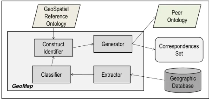
Our approach, named GeoMap, is based on the architecture depicted in Figure 2. From a geographic database, a peer ontology (i.e., an application ontology) is built by means of the GeoMap components: at first, the database schema is extracted, then its elements are classified into spatial and non spatial ones, then its respective geospatial OWL construct is identified and, finally, the peer ontology is generated. This ontology represents, through ontological concepts and properties, the structure of the database. In order to provide semantics when accomplishing the OWL construct identification, we use a geospatial domain ontology (a reference ontology). During the generation process, an OWL document is also automatically produced to record the set of correspondences (relationships) between the generated ontology components and the original database metadata. This document will later be used to translate ontological queries into the database query language and retrieve corresponding instances.
Extractor Geographic Database Classifier Construct Identifier Generator GeoSpatial Reference Ontology Peer Ontology Correspondences Set GeoMap
Figura 2. GeoMap Architecture
3.2 Reference Ontology
Using OWL as a common representation model, the SPEED system minimizes the problems of heterogeneity by transforming the schemas of data sources using ontologies. Nevertheless, regarding geospatial metadata, the set of predefined constructs in OWL does not include specifications for the description of geographical concepts and properties. Therefore, it was necessary to use some kind of background knowledge which could be a reference at the mapping process, when generating such geospatial constructs (tags). Although existing geospatial ontologies are available, we could not find out one which completely fitted our purposes. Thus, we have defined a geospatial domain ontology to be used as a reference in our process.
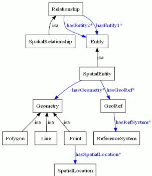
The reference ontology has been developed using the Protégé 3.4.4 tool [Protégé 2011]. An excerpt from this ontology is depicted in Figure 3, using the OntoViz notation [OntoViz 2011]. In this format, subtypes are associated with their supertypes through the isa relationship. Relationships between concepts are also presented through edges.
Figure 3. Excerpt from the Geospatial Reference Ontology
The reference ontology should be able to represent an abstraction of geospatial and non geospatial metadata, including, for example, entities, spatial entities, relationships, spatial relationships and geometry. In order to represent such concepts, we have defined specific high level concepts: Entity as the main concept;; SpatialEntity as a specialization of Entity representing a geographic phenomenon;; Relationship as a general kind of association between entities and SpatialRelationship as a specialization of Relationship regarding specific geospatial ones. A SpatialEntity has a Geometry (point, line or polygon) and is associated with a geospatial reference (a Reference System). Points are represented through spatial location, lines are defined through points and polygons are defined through lines.
3.3 Mapping Process
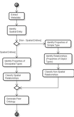
The mapping process used in GeoMap approach is based on the particular aspects described in the previous sections. An overview of its steps is presented in Figure 4. During this process, rules are applied to transform the geospatial schema elements from the database into geospatial ontology components. These rules include: (i) after connecting to the database, it extracts the database schema;; (ii) it identifies, among the obtained tables, which are non-spatial, i.e., tables that have no geographic columns;; (iii) meanwhile, it also identifies the spatial ones. Among the obtained tables, (iv) it identifies simple type properties (e.g., varchar and number types) and (v) it identifies
relationships which are mapped into object type properties, with the specification of domain and range, (vi) it also classifies these relationships as spatial or nonspatial ones. After processing all these steps, the tool produces an OWL file (i.e., the peer ontology) representing the geographic database schema.
Figure 4 . Peer Ontology Generation Process
In next section, we provide some implementation issues for GeoMap and present the tool underlying our approach through an example.
4. The GeoMap Tool: Experiments and Results
The GeoMap tool has been implemented in JAVA as an extension of an object- relational database ontology generation tool [Franco 2009]. In this current version,
GeoMap uses geographic databases coded in Oracle DBMS [Oracle 2010]. The Protégé- OWL API [Protégé 2011] and the Jena framework [Jena 2011] have been used for ontology manipulation.
In Figure 5, we present a use case diagram which shows the functional requirements that have been considered in the GeoMap tool implementation. There are two actors in the diagram. The first one is the GeoMap tool itself that starts the whole process of ontology mapping by connecting to the database. The database, in turn, characterizes the second actor. It is worth mentioning that, in this current version, the mapping options are initiated by a "user", i.e., manually by a GeoMap user. In a future version, the tool will be set in SPEED system as a service to be called whenever a peer (with geographic database) requests entering the system.
Figure 5. Use Case Diagram for the GeoMap Tool
After connecting to the database, GeoMap retrieves the existing geospatial types and tables from the database schema. Through this recovery, it is possible to extract all the columns, identifying what is a simple attribute and what represents a geometry. Then, the tool identifies the geometry type of geospatial tables - whether it is point, line or polygon. Based on the recovery of all entities and their properties (simple or objects), the tool makes use of the domain ontology as a reference of terms and creates the specific geospatial tags (i.e., constructs). Thus, when creating the spatial entities representation and referring the types of geometry, we use the reference domain ontology. When referencing the domain, we identify the domain of properties. When referencing the geographical range for a column, we specify the geometry types (line, polygon or point) present in the reference ontology.
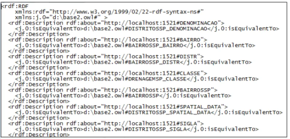
During the mapping of these metadata, it is also possible to identify the equivalence correspondences of the generated ontology components and the existing database schema entities and properties. In order to define this set of equivalence correspondences, we build an OWL document composed by a specific construct named
IsEquivalentTo. Such construct has been defined and used to indicate which ontology concept is equivalent to the database schema element. Also, it indicates which ontology properties are equivalent to the database schema attributes and relationships. An excerpt from a produced set of correspondences is depicted in Figure 6. In this example, we are working with a database regarding districts in São Paulo city. In the owl file, for instance, the SPATIAL_DATA column in the database schema corresponds to the DITRITOSSP_SPATIAL_DATA concept in the peer ontology, i.e., they are equivalent.
At end, the GeoMap tool produces two outputs: (i) the peer geospatial ontology and (ii) the owl document with the set of equivalence correspondences. As a way to present GeoMap tool main steps execution, we provide some examples in the following. 4.1 GeoMap in Practice
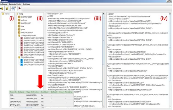
Figure 7 VKRZVDVFUHHQVKRWRIWKHWRRO¶VPDLQZLQGRZWKDWLVVSOLWLQWRIRXUSDUWV(i) area which identifies the database name, (ii) area showing the structure obtained from the database schema, (iii) area with the generated peer ontology and (iv) area with the set of produced correspondences. In this example, we use a geographic database that stores attributes and geometries from the neighborhoods, districts and drainage map of São Paulo city. For instance, the database table named "DistritoSP" is represented as a polygon through the Oracle type MDSYS.SDO_GEOMETRY. Its structure is presented in an expanded view also shown in Figure 7.
Figure 7. Geomap Interface and an Example of Database Schema
Particularly, another example regards using a geographic database that stores
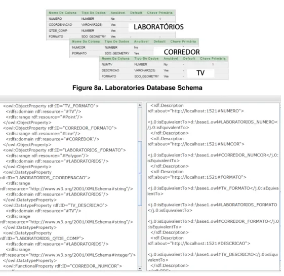
laboratories from IFPB Institute. According to the process explained in Section 3, the tool identifies spatial and non-spatial entities and properties from the database schema and generates the peer ontology and the set of equivalence correspondences. For the sake of visibility, we present the database schemas for the tables Laboratórios,
Corredor and TV apart from the interface (Figure 8a). In addition, we depict the generated peer ontology from such database and the set of obtained correspondences in Figure 8b.
Figure 8a. Laboratories Database Schema
Figure 8b. Produced Peer Ontology and Correspondences
We have accomplished some initial experiments with the GeoMap tool. The goal of our experiments is to check if we can assess completeness in terms of the produced peer ontology. According to some quality information criteria [Batista and Salgado 2007, Wang and Strong 1996], regarding PDMS systems, we have defined
completeness as the degree to which entities and properties of the peer data source (i.e. the database schema) are not missing in the generated peer ontology. In order to measure such criterion, we have invited some users (knowledgeable about the Geospatial domain and OWL/RDF constructs) to produce a manual peer ontology from the geographic database schemas. These ³JROGontologies´were compared with our produced peer ontologies. As result, we could verify that our produced peer ontologies are quite complete (ninety percent on average) in terms of the existing database elements, i.e., they include most of all the schema elements from the database. The different coPSRQHQWVREWDLQHGIURPWKH³JROG´RQWRORJLHVDQGRXUVUHJDUGHGVHPDQWLF
interpretations when defining the geometry types: the expert users defined point, line and polygon as owl:class while our tool is still generating them as rdf:datatype. In fact, it indicates a probable mistake that will be corrected. Furthermore, we intend to
accomplish additional experiments with other experts and other databases in order to obtain a more concrete result.
5. Related Work
Currently, there are many approaches and tools which build ontologies from databases [Franco 2009, Cerbah 2008, Cullot et al. 2007, Baglioni et al. 2007]. However, most of them are concerned with relational databases. As an example, the DB2OWL tool map relational databases to OWL ontologies, considering particular table cases during the mapping process [Cullot et al. 2007]. Another example regarding relational databases is the RDBToOnto tool [Cerbah 2008]. This tool produces an ontology and allows refining its generated version. To this end, RDBToOnto provides a visual interface for accomplishing manual changes. Lubyte and Tessaris define a framework for extracting from a relational database an ontology that is to be used as a conceptual view over the data [Lubyte and Tessaris 2007]. In this work, the semantic mapping between the database schema and the ontology is captured by associating a view over the source data to each element of the ontology (i.e., by means of a GAV approach) [Halevy 2001]. Regarding object-relational databases, the work of Franco [2009] implements a tool which provides the ontology built from such kind of database.
Particularly, in the geospatial realm, Cruz et al. [10] developed a semi-automatic method to generate mappings between ontologies of local databases and a global one. The generated mappings are then used for query rewriting. In a closer scope, Baglioni et al. [2007] defined a method to access spatial database through an ontology layer. To this end, they developed a semi-automatic tool which builds an application ontology from a geographical database. They also enrich the generated ontology with semantics from a domain ontology by finding correspondences between the classes and properties of the two ontologies. This work is the most similar to ours.
Comparing these works with ours, we are able to produce the peer ontology in an automatic way, by using the semantics provided by the reference ontology. In this light, we can use any background knowledge that may support the geospatial semantics we need. Thus, for instance, we will be able to use the OGC GeoSparql standard (when it is ready for use) as our domain reference. Furthermore, in our approach, we do not need the user intervention, since this current tool will be stated as a service in SPEED system which will be dynamically executed at peer arriving time.
6. Conclusions and Future Work
This work has presented the GeoMap approach and tool. GeoMap accomplishes the extraction of metadata from a geographic database representing them in terms of a peer ontology. Also, it identifies the equivalence correspondences between the generated ontology components and the existing database schema entities and properties. To this end, it takes into account the identification and classification of geospatial and non spatial entities and properties, figuring out how they can be represented in terms of an OWL ontology. A geospatial reference ontology is used as a way to provide the semantics of geospatial relationships and types, absent from the set of existing concepts in the OWL model.
Currently, this version generates ontologies from Oracle databases. As future work, it will be extended to also extract metadata from other DBMSs, such as PostGIS
and other data sources such as GML. Another important future work concerns identifying correspondences between geospatial peer ontologies. Thereby, we will be able to reformulate and execute geospatial queries among the existing peers in the PDMS.
References
Arpinar I. B., Sheth A., Ramakrishnan C., Usery E. L., Azami M. and Kwan M.
³Geospatial Ontology Development and Semantic Analytics´ ,Q +DQGERRN RI
Geographic Information Science. Blackwell Publishing (2004).
%DDGHU ) +RUURFNV , DQG 6DWWOHU 8 ³'HVFULSWLRQ /RJLFV´ ,QFrank van
Harmelen, Vladimir Lifschitz, and Bruce Porter, editors, Handbook of Knowledge Representation. Elsevier, 2007.
%DJOLRQL 0 0DVVHURWWL 0 5HQVR & 6SLQVDQWL / ³%XLOGLQJ *HRVSDWLDO
2QWRORJLHVIURP*HRJUDSKLFDO'DWDEDVHV´GeoS 2007: 195-209.
Batista M. C., Salgado A.C. (2007) ³Data Integration Schema Analysis: An Approach with Information Quality´. In Proceedings of the 12th International Conference on Information Quality (ICIQ), MIT, Massachusetts, USA, October 2007.
&HUEDK)³/HDUQLQJ+LJKO\6WUXFWXUHG6HPDQWLF5HSRVLWRULHVIURP5HODWLRQDO
Databases ± 7KH 5'%WR2QWR 7RRO´ ,Q WK (XURSHDQ 6HPDQWLF :HE &RQIHUHQFH
(6:&¶SDJHV77-781, Tenerife, Spain (2008).
Cruz, I. ) 6XQQD : &KDXGKU\ $ ³6HPL-automatic ontology alignment for
JHRVSDWLDO GDWD LQWHJUDWLRQ´ ,Q (JHQKRIHU 0- )UHNVD & 0LOOHU +- HGV
GIScience 2004. LNCS, vol. 3234, pp. 51±66. Springer, Heidelberg (2004).
&XOORW 1 *KDZL 5 DQG <pWRQJQRQ . ³'%2:/ $ 7RRO IRU $XWRPDWLF
Database-to-Ontology Mapping". In: 15th Italian Symposium on Advanced Database
6\VWHPV6(%'¶SDJHV-494, Torre Canne di Fasano (BR), Italy (2007).
Fonseca, F. T., Davis Jr. C. A., Camara G. ³Bridging Ontologies and Conceptual Schemas in Geographic Applications Development´. Geoinformatica, v. 7, p. 355- 378, 2003.
)UDQFR)³8PD)HUUDPHQWDGH7UDQVIRUPDomRGH(VTXHPDV2EMHWR-Relacionais
para OntRORJLDV´Trabalho de Graduação, Centro de Informática, Universidade Federal de Pernambuco (UFPE), Recife, PE, Brasil.
Geography Markup Language (2007). Available at:
http://www.opengeospatial.org/standards/gml. Last access on august 15th, 2011.
GeoSPARQL documentation (2011). Available at:
http://www.opengeospatial.org/projects/groups/geosparqlswg. Last access on august 15th, 2011.
*KDZL5DQG&XOORW1³%XLOGLQJ2QWRORJLHVIURP0XOWLSOH,QIRUPDWLRQ6RXUFHV´,Q
15th Conference on Information and Software Technologies (IT2009) (Kaunas, Lithuania, April 2009).
+DOHY\ $ ³$QVZHULQJ TXHULHV XVLQJ YLHZV $ VXUYH\´ 9/'% Journal,
+HVV * ³Towards effective geographic ontology semantic similarity
DVVHVVPHQW´PhD Thesis. UFRGS.
+HVV*,RFKSH&&DVWDQR6³7RZDUGVD*HRJUDSKLF2QWRORJ\5HIHUHQFH0RGHOIRU
0DWFKLQJ3XUSRVHV´GeoInfo 2007: 35-47.
+RUURFNV , ³$SSOLFDWLRQV RI GHVFULSWLRQ ORJLFV 6WDWH RI WKH DUW DQG UHVHDUFK
FKDOOHQJHV´ 3URF RI WKH WK ,QW &RQI RQ &RQFHSWXDO 6WUXFWures (ICCS'05)
April 2005.
Jena (2011). Jena - A Semantic Web Framework for Java. http://jena.sourceforge.net/
/RGL 6 3HQ]R : 0DQGUHROL ) 0DUWRJOLD 5 DQG 6DVVDWHOOL 6 ³6HPDQWLF 3HHU
Here are the NHLJKERUV <RX :DQW´ ,Q WK ([WHQGLQJ 'DWDEDVH 7HFKQRORJ\
('%7¶1DQWHV)UDQFHSS-37 (2008).
Lubyte L., 7HVVDULV 6 ³([WUDFWLQJ RQWRORJLHV IURP UHODWLRQDO GDWDEDVHV´ ,Q
3URFRIWKHWK,QW:RUNVKRSRQ'HVFULSWLRQ/RJLFV'/
OntoViz (2011). Available at: http://protegewiki.stanford.edu/wiki/OntoViz. Last access on august 18th, 2011.
OpenGIS (2011). Available at: http://www.opengeospatial.org/standards. Last access on august 15th, 2011.
Oracle 10g documentation (2010). Available at:
http://www.oracle.com/technetwork/indexes/documentation/index.html. Last access on august 15th, 2011.
OWL API (2011) ± available at: http://protege.stanford.edu/plugins/owl/api/. Last access on august 15th, 2011.
3LUHV&(6³2QWRORJ\-%DVHG&OXVWHULQJLQD3HHU'DWD0DQDJHPHQW6\VWHP´
PhD thesis, Center for Informatics, UFPE, 2009.
PostGIS documentation (2011). Available at:
http://postgis.refractions.net/documentation/. Last access on august 15th, 2011.
6RX]D ' 3LUHV & ( .HGDG = 7HGHVFR 3 & 6DOJDGR $ & ³$ 6HPDQWLF-
based ApproDFKIRU'DWD0DQDJHPHQWLQD336\VWHP´7REHSXEOLVKHGLQ/1&6
Transactions on Large-Scale Data- and Knowledge-Centered Systems, 2011.
6XQJ / * $ $KPHG 1 %ODQFR 5 /L + 6ROLPDQ 0 $ +DGDOOHU ' ³$
Survey of Data Management in Peer-to-PHHU6\VWHPV´6FKRRORI&RPSXWHU6FLHQFH
University of Waterloo.
Wang R. Y., Strong D. M. ³Beyond Accuracy: What Data Quality Means to Data Consumers´. Journal of Management Information Systems, Vol. 12, N. 4, pages 5-33, 1996.
Xiao H. ³4XHU\SURFHVVLQJIRUKHWHURJHQHRXVGDWDLQWHJUDWLRQXVLQJRQWRORJLHV´
PhD Thesis in Computer Science. University of Illinois at Chicago, 2006.
Zhai X., Huang L., and Xiao, Z. ³Geo-spatial query based on extended SPARQL´. In Proceedings of Geoinformatics. 2010, 1-4.
=KDR - ³6FKHPD 0HGLDWLRQ DQG 4XHU\ 3URFHVVLQJ LQ 3HHU 'DWD 0DQDJHPHQW