Implementation on GPS Enabled City Bus
Tracking System and Smart Ticketing
Aishwary Borkar, Aishwarya Auti, Trupti Kamble, Shubham Sawant, Prof. Mandar Mokashi
Dept. of Computer Engineering, Dr. D Y Patil School of Engineering, Lohegaon,(CharoliBk), Savitribai Phule Pune
University, Pune, India
ABSTRACT: The goal of this paper is to review the past work of monitoring and alerting system, to categorize various methodologies and identify new trends. City bus, monitoring and alerting system is challenging problem. There are various challenges we encounter in monitoring city public transport bus due to deficiency in proper real time vehicle location. GPS (Global Positioning System) is most widely used technology for vehicle tracking and regular monitoring of vehicle. The objective of city bus system is to manage and control the transport using GPS transceiver to know the current location of vehicle. In number of system, it is most widely used for alerting system. Real time track interface system is essential for providing the location and information about vehicle to passenger, owner or user.
KEYWORDS: Global Positioning System, Global System for Mobile Communication, Raspberry pi, IR sensor
I. INTRODUCTION
In the daily operation of public transport systems i.e. Frameworks, when travelers use the public transport, every time they confront the troubles when the transport comes up short amid progressing venture. The transport driver and the conductor attempt all alone to discover the answer for the transport disappointment. To get the vital offer assistance from confirmed sources is truly troublesome and protracted. Amid this feverish procedure all passengers don’t have some other alternative yet to hold up. Be that as it may, passengers in the transport have no clue at the point when the real cause will arrive or not. They go into predicament whether to sit tight there for help to arrive or to move by private vehicle. This is truly tedious prepare and irritating for passengers.
II. OBJECTIVES
The objective of the proposed system is given below 1. To track the bus using GPS
2. Accurate ticketing of passengers
III LITERATURE SURVEY
In literature, the problem and the previous techniques of monitoring and alerting system is described, Pengfei Zhou,
et.al.In this paper, they introduce a group took an interest transport landing time expectation framework. Basically depending on economicalalso, broadly accessible cell flags, the proposed framework give cost-effective answers for the issue. They extensively assess the framework through an Android model framework.[1]
AbidKhan Et.al This framework is useful for open transport vehicles, for example, transports and taxicabs, it gives Tele checking and administration framework for the transportation of the cabs and transports inside the city. In this paper the framework said comprises of a ―On-board module‖ which is mounted in the vehicle which is to be followed. This on -board module comprises of Global Positioning System, a GSM modem and ARM processor. The route message which is communicated by the GPS position satellite is gotten and settled by the GPS recipient of the vehicle terminal. This satellite processes the longitudes and scopes of vehicle directions, then change it into the short message shape by utilizing GSM correspondence controller and this message is sent to the observing focus through the GSM network [3]
PankajVerma et.althis framework utilizes Global Positioning System (GPS) which is utilized to get the directions of scope and longitude shape the satellite amid the basic data. We as a whole realize that following framework is currently a-days an essential in present day world. This framework can be utilized as a part of the checking of troopers, additionally in following the robbery of the vehicle and in numerous more different applications. This framework utilizes microcontroller, Global Positioning System (GPS) and Global System for Mobile Communication (GSM). This framework utilizes just a single GPS gadget and GSM empower a two way correspondence handle. GSM modem is give a SIM card which utilizes the same and consistent correspondence prepare as we are utilizing as a part of general phone.[4]
BaburaoKodavati et.alThis paper uses to a RF transmitted; the RF transmitter is joined with the vehicle which comprises of its own recognizable proof. The information which will be consistently transmitting to the RF recipient that is associated with the microcontroller. The GPS will get the area of the vehicle and will transmit this information to the microcontroller. Evidently the RF transmitter is not getting the flag from the RF transmitter then the accepting unit triggers a flag to the microcontroller, and from this flag we can recognize the burglary. On the off chance that it is distinguished that the vehicle is burglary then it consequently sends area of the vehicle to its client as the proprietor of the vehicle gets the data as SMS through the GSM modem. This framework is substantially more straightforward and financially savvy than the others. The vehicle is naturally halted if a secret word like SMS sent by the client. [5] Iman M. Almomani, et.al proposes the system in which the Global Positioning System (GPS) is ending up noticeably broadly utilized for tracking and monitoring vehicles. Numerous frameworks have been made to give such administrations which make them prominent and required like never before some time recently. In this paper a " GPS vehicle tracking system" is proposed. This framework is helpful for armada administrators in observing driving conduct of workers or guardians checking their high schooler drivers. In addition, this framework can be utilized as a part of robbery anticipation as a recovery gadget likewise of filling in as a security framework joined with auto cautions. The principle commitment of this paper is giving two sorts of end client applications, a web application and a portable application. Thusly the proposed framework gives an omnipresent vehicle following framework with most extreme openness for the client at whatever time and anyplace. [6]
Advantages:-Stolen tracking vehicles in our system utilizes a wide range of new technologies and communication networks including GPRS, GSM.
Disadvantages:- It is not applicable for mobile application[6]
Hsu-Yung Cheng*et.al in this work, a vehicle tracking system is created to manage daytime and evening time traffic surveillance videos. For daytime recordings, vehicles are distinguished by means of foundation demonstrating. For evening recordings, headlights of vehicles should be found and matched to instate vehicles for the following reason. A calculation in view of probability calculation is produced to combine the headlights of vehicles. Likewise, we apply a specific framework state move model of the Kalman channel to adjust to basic settings of activity observation cameras. The exploratory outcomes have demonstrated that the proposed strategy can adequately track vehicles in both daytime and evening time surveillance videos. [7]
Advantages:- However, it is difficult to segment out the entire vehicles at night. For nighttime surveillance videos, foreground objects that can be detected are usually headlights, auxiliary lights, or reflections of lights of the vehicles. Headlights are important features for initializing vehicles for tracking at night.
Disadvantages:-Some problem in nighttime surveillance video.[7]
following, and conduct examination. This paper is an overview that locations especially the issues identified with vehicle checking with cameras at street convergences. Actually, the last has variable designs and speaks to a basic zone in activity. Mischances at crossing points are amazingly perilous, and the vast majority of them are brought on by drivers' mistakes. A few activities have been completed to improve the wellbeing of drivers in the unique setting of crossing points. In this paper, they give a diagram of vehicle discernment frameworks at street crossing points and delegate related informational collections. The peruser is then given an early on diagram of general vision-based vehicle checking approaches. Along these lines or more all, they exhibit an audit of studies identified with vehicle location and following in crossing point like situations. As to Monitoring, they recognize and think about roadside (shaft mounted, stationary) and in-vehicle (portable stages) frameworks. At that point, they concentrate on camera-based roadside observing frameworks, with extraordinary consideration regarding unidirectional setups. At long last, they introduce conceivable research headings that are probably going to enhance the execution of vehicle recognition and following at crossing points
Advantages:-in environment modeling, vehicle detection, tracking, and behavior analysis
Dis advantages:-In congestion of vehicle tracking of vehicle is difficult
Ronald de Feijter et.al [9] proposes the system in which the congestion of our infrastructure, particularly (urban) motorways, keeps on expanding. Proficient arranging, for example in cargo transport, is ruined by the subsequent lack of quality of travel times. Another impact of this blockage is a diminished usage rate of the street. This paper presents trip booking; a technique went for development of the unwavering quality of travel times and in addition an expansion in the compelling utilization of street limit. Expanded dependability encourages better strategic arranging. Besides, it permits the sharing of foundation between various modalities, with every methodology having its own operational time window. The framework goes for open committed foundation, for example, transport paths and devoted cargo paths, and jellies the self-governance of both the supplier and client of the framework. The preferred standpoint cases are bolstered by recreation comes about for essential system designs.
Advantages:-Increased reliability facilitates better logistic planning.
Disadvantages:- Disturbances such as capacity drops
Thuong Le-Tien, Vu Hung et.al [10] The paper describes a practical model for routing and tracking with mobile vehicle in a large area outdoor environment based on the Global Positioning System (GPS) and Global System for Mobile Communication (GSM). The supporting devices, GPS module-eMD3620 of AT&S company and GSM modem-GM862 of Telit company, are controlled by a 32bits microcontroller LM3S2965 implemented a new version ARM Cortex M3 core. The system is equipped the Compass sensor-YAS529of Yamaha company and Accelerator sensor KXSC72050 of Koinix company to determinemoving direction of a vehicle. The device will collect positions of the vehicle via GPS receiver and then sends the data of positions to supervised center by the SMS (Short Message Services) or GPRS (General Package Radio Service) service. The supervised center is composed of a development kit that supports GSM techniques-WMP100 of the Waveform company. After processing data, the position of the mobile vehicle will be displayed on Google Map
Advantages:-A practical system for routing and tracking mobile vehicle was presented in this paper.
Disadvantages:-The accuracy of system is affected by some factors such as weather, environment around the mobile vehicle
Pham Hoang Oat.et.al [11] et.al portrays the Tracking vehicles is a vital and testing issue in video-based Intelligent Transportation Systems and has been comprehensively examined previously. This paper introduces a powerful and ongoing technique for following vehicles and the proposed calculation incorporates two phases: protest district extraction, vehicle following. Protest district extraction is a key stride and the idea of following vehicle is based upon the vehicle-division technique. As indicated by the portioned vehicle shape, we propose a three-stage foresee technique in view of Kalman channel to track every vehicle. The proposed strategy has been tried on various monocular activity picture arrangements and the test comes about demonstrate that the calculation is strong and constant. The right rate of vehicle following is higher than 85 percent, free of environmental conditions
Advantages:- robust and real-time method for tracking vehicles
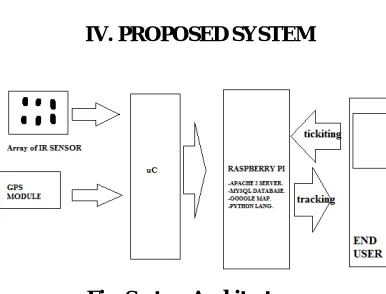
IV. PROPOSED SYSTEM
Fig. System Architecture:-
In this project IR sensor are connect directly to microcontroller (port pin). The GPS is connected via serial cable anddata his send to server by mean of wireless commutation.The data is received at server side which is operating on Linux based system. Which will support the MYSQL baseddata base which contain all detail:-
Location
The server runs on it. To fulfill the entire above requirement we had used the raspberry pi.Which is easily can run server all command and support all sever function. The data form server can made available toned user using mobile application or web page. These things can be control dynamically from both side i.e. user command can be answered from server side which make it complete IOT based system.
Functions of the system can be stated as:
Registration () – Function for registration purposes.
Authentication () – Socket Programming Function for connection with server.
Identification () – For identification of an authorized user.
Exception () – To throw exception if user balance falls below appropriate levels.
Transaction (fare output) – Algorithm for deduction of balance from user account database.
Notification () – To notify the user about transaction status as well as if the balance is low.
GPS Component:
In order to build software for digitized data, the continuous signals must be transformed into the discrete signals,
Where is a sampling interval, Now above relation is substitute in following equation. Expression of co-ordinates-
Where xi, yi, zi are the known co-ordinates of the satellite in the space and x,y,z are the unknown co-ordinate of observer on earth surface.
V. RESULTS OF IMPLEMENTATIONS
1. User Registration
2. User Login
4. Bus Monitoring
5. Bus Information
6. View Account Details
VI. CONCLUSION
own importance; different authors have tried different methods based on applications. Still there is scope to optimize different methodologies and algorithm to make system more users friendly and wide application areas
REFERRENCES
[1] Pengfei Zhou, YuanqingZheng, and Mo Li “How Long to Wait? Predicting Bus Arrival Time With Mobile Phone Based Participatory Sensing”
IEEETRANSACTIONS ON MOBILE COMPUTING, VOL. 13, NO. 6, JUNE 2014 1228-1241.
[2]AmolDhumal, AmolNaikoji, YutikaPatwa, ManaliShilimkar, Prof. M. K. Nigho “Survey Paper on Vehicle Tracking System using GPS and Android” International Journal of Advanced Research in Computer Engineering & Technology (IJARCET) Volume 3 Issue 11, November 2014
[3] Abid Khan & Ravi Mishra ―GPS – GSM Based Tracking System‖ International Journal of Engineering Trends and Technology- Volume 3 Issue 2- 2012 ISSN: 2231-5381.
[4] PankajVerma&J.S.Bhatia ―Design and development of GPS-GSM based tracking system with Google map based monitoring.‖ International
journal of computer science, engineering and applications (ijcsea) vol.3, no.3, June 2013
[5] BaburaoKodavati, V.K.Raju, S.SrinivasaRao, A.V.Prabu, T.AppaRao, Dr.Y.V.Narayana, ―GSM and GPS based vehicle location and tracking system‖ International journal of engineering research and applications (ijera) issn:2248-9622 vol. 1, issue 3,pp.616-625.
[6] “Ubiquitous GPS Vehicle Tracking and Management System” Iman M. Almomani, Nour Y. Alkhalil, Enas M. Ahmad, Rania M. Jodeh [7] “Vehicle Tracking in Daytime and Nighttime Traffic Surveillance Videos” Hsu-Yung Cheng*, Po-Yi Liu, Yen-Ju Lai
[8] “A Survey of Vision-Based Traffic Monitoring of Road Intersections”Sokèmi René Emmanuel Datondji, Yohan Dupuis, Peggy Subirats, and Pascal Vasseur
[9] “Improving Travel-Time Reliability by the Use of Trip” Booking Ronald de Feijter, Joseph J. M. Evers, and Gabriel Lodewijks [10] “Routing and Tracking System for Mobile Vehicles in Large Area” Thuong Le-Tien, Vu Hung-The