Vol. 4, Issue 3, March 2015
Geo Service Automatic Mobile Alert System
P.Deepika
1, S.Sangavi
2, B.Sakthi Karthi Durai
3U.G. Student, Department of Information Technology, Latha Mathavan Engineering College, Madurai, Tamilnadu,
India1
U.G. Student, Department of Information Technology, Latha Mathavan Engineering College, Madurai, Tamilnadu,
India2
Associate Professor, Department of Information Technology, Latha Mathavan Engineering College, Madurai,
Tamilnadu, India3
ABSTRACT: The mobile phone leads to increase in accidents due to use of cell phone while driving, Drivers using Mobile phone involved in road accidents. So in this project we are providing a solution, By using Global Positioning System, The Application automatically starts the mobile app working accordingly the app intimate the call (As information or Message alert tune) to the driver and the call aborted automatically and send the message to the caller and tend driver to stop the vehicle and continue the conversation on cell phone. In future updates developing fabrication method in the throttle connecting the mobile applications.
.
KEYWORDS: GPS, Geo Service, Driver Preference, Message Alert, Bluetooth, Kilometre Calculation, Longitude
Latitude.
I.
I
NTRODUCTIONTalking on cell phones while driving distracts the driver and he fails to maintain the required attention on driving. Hands free phones can also distract drivers, but the current evidence suggests that hand-held phones pose a greater problem. This risk also extends to pedestrians. So to avoid this problem and with the aim of preventing such accidents, it is proposed to develop a highly efficient automatic system for detection of usage of cell phone by driver which helps in eliminating the risk of accidents from occurring, at the same time ensuring that the user does not miss any call. Main used aspect was GPS that describes the GPS in this case logs the position of the object and stores the required information. This information in modern GPS is generally recorded in a memory card or internal flash memory and a USB port. It is a very useful tool in Police investigation cases where the objects (generally vehicles or fleet vehicles) position can be known without going closer to the object.
The GPS in this case sends or pushes the information to an
external server, which analyzes the data sent. The procedure followed is fairly simple in which the GPS receiver gets the data sent by the mobile phone (Information generally sent by SMS). Some companies provide this kind of tracker in business environments also. A typical tracking system has both the tracking device along with the software, called Automatic vehicle system. The data pullers are opposite to the data pushers where the information can be taken or queried as long the user wants to. This is based on the pull technology. GPS work system in a mobile phone describes as1. Get some information from the cell phone company to feed to the GPS receiver - some of this is gross positioning
2. Information based on what cellular towers can 'hear' your phone, so by this time they already phone your location to within a city block or so.
3. Switch from cellular to GPS receiver for 0.1 second (or some small, practically unnoticeable period of time) and collect the raw GPS data (no processing on the phone).
4. Switch back to the phone mode, and send the raw data to the phone company
Vol. 4, Issue 3, March 2015
Paper is organized as follows. Section II describes automatic alert system using GSM and RF based system next work describes the visual and mechanical distractions. The flow diagram represents the step of the algorithm. The diagram represents the detailed work of the GPS application that is given in Section III. Section IV presents experimental results showing results of images tested. Finally, Section V presents conclusion.
II. RELATEDWORK
Prof. Abhay P. Bagade Assistant Professor, Dept. Of E & T Engg., B. D. College of Engineering, Sevagram, Maharashtra, India.
If accident happens then the emergency messages initiative aims to obtain a very fast reaction from the emergency services for such critical or emergency conditions. This may reduce the probability of death in road trips. By using the current emergency message system from the safety, the emergency services operating from the Public-safety Answering Point (PSAP) can instantly identify the vehicle’s location by GSM tracing and establish a phone call to evaluate the seriousness of the accident. This project describes a more advanced emergency message (eMsg) approach that provides the emergency services with enriched information about the state of the car. Also suddenly activation of RF system after accident helps to inform nearer vehicle for the indication of accident condition for getting quick help. This paper covers three systems as Cell-Phone Avoidance Alert System, GSM Based Accident Alert System, and RF Based Accident Alert System.
Anjali Sarath1, Ancymon S2, Anil Varghese3,Anand N.V4, Krishnachandran R5, Janahanlal P. S6 Electronics and Communication and Engineering, MG University, Matha College of Technology, Ernakulam, Kerala, India.
Mobile phones can be an essential means of communication when we are away from the office or home and it can be an important security asset in the event of an emergency. However, there is a considerable concern that using a mobile phone while driving creates a significant accident risk to the user and to the other people on the road, because it distracts the driver, impairs their control of the vehicle and reduces their awareness of what is happening on the road around them. There are two types of distraction .They include Physical distraction (visual and mechanical) Cognitive distraction. To reduce the risk and accident due to mobile phone usage while driving we are developing a model to prevent the usage of mobile phone during driving. The system allows the call if it is emergency only, and when the call is attended the speed is automatically reduced and to show the vehicle is reducing the speed a backlight is provided. In school and hospital zone the speed of the vehicle is automatically reduced. Accident is detected using pressure sensor and using GPS the position of the vehicle is detected and message is sent to pre stored number using GSM technology. The system also highlights the vehicle theft that is when vehicle is lost the driver can send message to the systems
III. THEORETICALSTUDYOFPROPOSEDSYSTEM
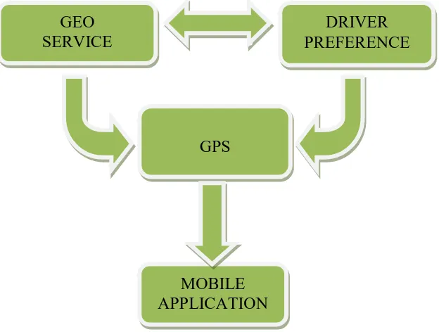
To achieve the desired goal I was manufactured a whole block diagram in fig 1. The block diagram consist of inner layer of the alert system using longitude, latitude connections and speed calculation using a geo services, Here the GP system track the location and screen the longitude latitude and the kilometre speed to abort the call when the speed kilometre was extended, Geo service are used to calculate the speed using code
criteria.setSpeedRequired(true);
locationManager.requestLocationUpdates(s, 0L, 1.0F, this); intent.setAction("com_speed.com.speed.com_speed"); intent.putExtra("_speed", "Drive Reply OFF");
speed_float = 2.2400000000000002D * (double)location.getSpeed(); speed_float = 2.2400000000000002D * (double)location.getSpeed();
Vol. 4, Issue 3, March 2015
return sp.getString("_latitude", "0.0"); }
public String getLongitude() {
return sp.getString("_longitude", "0.0"); }
The keyword driver reference act as a main component to define the path and the driver services to the applications. The GPS system used to track and find the locations and send the message ring to the receiver. The working principle of the GPS explained as All Location API methods require the ACCESS_COARSE_LOCATION or ACCESS_FINE_LOCATION permissions. If your application only has the coarse permission then it will not have access to the GPS or passive location providers. Other providers will still return location results, but the update rate will be throttled and the exact location will be obfuscated to a coarse level of accuracy.
String KEY_LOCATION_CHANGED:
Key used for a Bundle extra holding a Location value when a location change is broadcast using a Pending Intent.
Fig. 1 Flow diagram of whole application system Android keys:
android.location.LocationManager You do not instantiate this class directly; instead, retrieve it through
Context.getSystemService (Context.LOCATION_SERVICE).
Fig. 1 explains that the combination of geo service and preference in android helps to define the driver status and broadcast receiver process. It leads to work with GPS to perform the automatic alert system. GPS informs the current position as longitude and latitude in the mobile application and also the receivers speed calculation status in Kmph/s.
MOBILE
APPLICATION
GPS
GEO
SERVICE
Vol. 4, Issue 3, March 2015
III. DESIGNINGANDIMPLEMENTATION
For Designing and implementation the software needs Android Eclipse SDK. The future update needs an external device using fabrications. GPS module has been used to perform the location based and the speed calculation based applications. Where the programming language used in the application was java which it can handle the operation of software component. Implementation consists of designing the page and code internal structure.
In the implementation method there must be a connection between the transmitter and the receiver to indentify the call which was aborted and identify to intimate the message. Here the message performs some tone to intimate as by the normal message after downloading the application the person must change their tone for application. Because the intimation was the important factor which plays the major role in the geo service automatic mobile alert system to determine the user about the accident alert while driving
By using this design their will be combinations of fabrication method using touch sensor here we never introduced the fabrication we consider the fabrication as in future concern
IV.EXPERIMENTALRESULTS
The Result of our application performs as in many cases. The first case of the application describes the installation of the application in the play store. Because of installing in to the play store any one can download easily in to their mobile. In second case the opened application without designed simply like a blink option for applications. It’s like a starter for application page. In case 3 the application entered in to the internal work structure their driver preference and the geo services where used to perform the calculation of speed with on, off strategy using GPS. Whereas the message content for SMS which was user friendly to write in the text box for caller and receiver shone in the third view of the result.
Vol. 4, Issue 3, March 2015
Case 1(APP NAME)DriveReply Case 2(SPLASH SCREEN)
Vol. 4, Issue 3, March 2015
V. CONCLUSION
We have implemented an automatic call aborted system using the GPS, geo service and driver preference system. Our application successfully installed in a play store. We have applied our own idea to implement this application. In future we are going to combine our application in to fabrication method. This system is very much compatible to any kind of vehicle. Overall our system is very much affordable to a common man which can be easily implemented.
VI.ACKNOWLEDGEMENT
The authors are thankful to the Head of the Department of Information Technology for providing laboratory facilities for developing the apps in preparation of this manuscript.
REFERENCES
[1] Prof. Abhay P. Bagade, “Cell Phone Usage While Driving Avoidance with GSM-RF Based Accident Emergency Alert System” International Journal of Advanced Research in Computer and Communication Engineering, Vol. 2, Issue 5, May 2013.
[2] Anjali Sarath1, Ancymon S2, Anil Varghese3,Anand N.V4, Krishnachandran R5, Janahanlal P. S6 “Automatic Mobile Phone Usage Prevention While Driving Using GSM Technology” International Journal of Research in Engineering & Advanced Technology, Volume 2, Issue 2, Apr-May, 2014
[3] www.freepatentsonline.com/6370475
BIOGRAPHY
Name: DEEPIKA P
Affiliation: U. G. Student at Department of Information Technology, Latha Mathavan Engineering College, Madurai-625006. Specialization / Interest Area: Application development, Java.
Name: SANGAVI S
Affiliation: U. G. Student at Department of Information Technology, Latha Mathavan Engineering College, Madurai-625006.Specialization / Interest Area: Application development, Java.
Name: SAKTHI KARTHI DURAI B