EXCAVATIONS AT HALAI, 1990-1991
(PLATES 69-74)
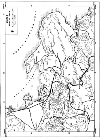
,TL4TALAI, a small ancient town in East or Opuntian Lokris,l is situated hard by the sea
Jll
lon the eastern shore of the bay known to Strabo (9.4.2) as the Opuntian Gulf and called in modern times the Bay of Atalante (Fig. 1). The site falls within the boundaries of the modern town of Theologos, a former fishing village which has become a popular family vacation spot.2 Earlier excavations by a team representing the American School of Classical Studies at Athens have shown that Halai had a fortified acropolis in classical times which continued to be occupied until Late Roman or Byzantine times and that extensive Neolithic deposits underlay the classical ones. Two hundred and eighty tombs of Archaic, Classical, and Hellenistic date were also excavated near the outer boundaries of the town to the north and east of the acropolis.The earlier excavations were carried out from 1911 to 1935 by Hetty Goldman and Alice Walker (Kosmopoulos). Annual campaigns took place from 1911 until 1914; these were described in a preliminary report,3 and the inscriptions discovered were published separately.4 Goldman and Walker also both completed doctoral dissertations on finds from the tombs excavated in the first four campaigns.5 Further campaigns took place in 1921, 1923, 1931, and 1935. In 1931 Goldman and Walker were assisted by Virginia Grace. No preliminary reports for these campaigns were issued, although Goldman published a few finds from the acropolis.6
Although the work of 1911-1935 was never published in full detail, Goldman eventu- ally produced a long and invaluable article summarizing the Greek and Roman finds on the acropolis7 and co-authored another on the terracotta sculpture from the tombs.8 The Greek and Roman finds from the earlier excavations were deposited in the Archaeological Mu- seum in Thebes, the Neolithic finds in the National Archaeological Museum in Athens.
In recent years Dr. Robert Bridges, current Secretary of the American School of Classi- cal Studies at Athens, has been studying the Neolithic finds from the earlier excavations,9 and he expects soon to publish them. He has kindly put the results of his study to date at the
I Ancient East Lokris is located within the modern district (eparchia) of Lokris, which is the southeastern-
most district of the province (nomos) of Phthiotis.
2 Rapid expansion of Theologos in recent years poses a considerable threat to the antiquities. The major
access road for points along the northeast shore of the bay passes over the acropolis of Halai (Figs. 3, 4).
3 Walker and Goldman 1915.
4 Goldman 1915.
5 Goldman 1916; Walker 1916.
6 Goldman 1930.
Goldman 1940.
8 Goldman and Jones 1942.
The records of the old excavations are largely extant at the American School of Classical Studies in Athens and at Bryn Mawr College. Thanks to the kindness of these institutions, members of our expedition have obtained copies and have spent many winter hours reading and analyzing them. Bryn Mawr College has also lent us all the photographic negatives and prints of Halai in its possession. The old records have been put in order and catalogued by Dr. Bridges in the course of his study of the old Neolithic finds.
American School of Classical Studies at Athens is collaborating with JSTOR to digitize, preserve, and extend access to Hesperia
xv
; s- SURVEY AREA
- ~ ~ ~~~~~~~~~~~~~~~~~~~~~~~~~~~~0 2 3 4k2,
0 ~~~~~~~~~~SCsI 1:510,000
-- 1 0~~~~~~~~~~~~
A. 41~~~~~~~~~~~~~~
JX~~ ' F_ 40
FIG.S1The CI-In Eat L
7*PIw r * ~~~~~~~~~~~~~~~~~~~~~~~~~~~~0
0 v / < , K 4~~~~~~~~~~~;" e F |
40
\< h---\ /4 4
oLANTE \ t
~~~~~~~~~~~~~~~~r Io k
35
N. PHHIT
..
00An/g'a-
SiS'ns
SoEXCAVATIONS AT HALAI, 1990-1991 267
..i.~~~~~~~~~~~.
....0100 200 m
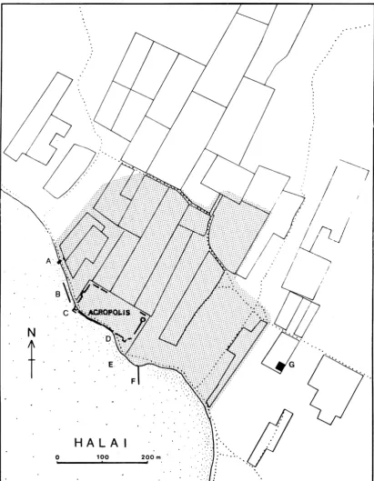
FIG. 2. Plan of the town of Halai. Stippled area: greatest concentration of sherds found during surface survey.
disposal of our expedition. In 1988 and 1989 the Greek Archaeological Service excavated several dozen additional tombs to the east of the acropolis (at G in Fig. 2).
Before the current excavations began, preliminary activities were carried out for several years, including the establishment of a surface survey area of about 185 sq. km. centering on Halai (Fig. 1), intensive surface survey in and around Halai (Fig. 2), and the preparation of a new plan of the acropolis of Halai at 1:50 scale (which formed the basis for Fig. 3).
The surface survey of 1988/1989 suggests that an additional outer ring of fortifications was built around the town of Halai in the 4th century B.C. or in Hellenistic times.10 The
wall would have followed the outer line of the stippled area in Figure 2. The line of blocks extending southeast-northwest along the present beach to the northwest of the acropolis (Fig. 2 at B) is more plausibly identified as part of this outer fortification wall than as the remains of shipsheds, as has often been proposed.11
These preliminary activities, as well as the actual excavations at Halai, are part of an interdisciplinary project of survey and excavation in East Lokris (the Cornell Halai and East Lokris Project) directed by the undersigned. 12 The excavations have been supported in part by grants from the National Endowment for the Humanities, the Townsend Fund of the Department of Classics, Cornell University, and the Institute for Aegean Prehistory, as well as by private donations.13
10 The surface survey was co-directed by William M. Murray of the University of South Florida. A report
is in final preparation.
E.g., Goldman 1940, p. 397.
12 The current project was first conceived in 1984 during archaeological prospecting trips in Central
Greece. Plans were then formulated for a long-term regional archaeological survey and excavation project, the Cornell Halai and East Lokris Project (CHELP). The overall aim of CHELP is to record and study the archaeological and environmental evidence for human activity from the beginning of the Neolithic period until Byzantine times. The study region, about 185 sq. km., centers on Halai and its boundaries, and it includes all territory that might have belonged to Halai at one time or another.
The first phase of the project (1986-1987) comprised initial prospecting and study of previous finds from Halai. In 1986 nine people besides the author took part, including two graduate students from Cornell Uni- versity (Richard Economakis and Dora Katsonopoulou) and six undergraduates from Cornell and Hunter College. At Halai, work was begun on a site plan at 1:50 scale under the leadership of Richard Economakis. A 10 m. grid and a network of elevations were also established. Dora Katsonopoulou was in charge of study of the finds from the old excavations. The study team recorded 950 pots and other objects at Thebes and looked at several dozen antiquities at Lamia. Participants in 1987 included the author, Dora Katsonopoulou, Aileen Ajootian, Nikos Constantinides, Rachel A. Coleman, Bonnie S. Gordon, and Constantine Vonortas. The major focus was continued work on the 1:50 site plan under the supervision of Nikos Constantinides. A cata- logue of the most significant architectural fragments still extant was also prepared by Aileen Ajootian.
The second phase (1988-1989) comprised surface survey, mainly at Halai and Mitrou, the two chief coastal sites of the region. Detailed reports on the results of this work are in preparation.
The third phase comprises the present excavations at Halai. It will be followed by a fourth phase com- prising several years of study leading to a full publication of the work at Halai. Subsequently, we plan further surface survey to identify and document other sites in the region.
13 We offer our sincere thanks to these granting agencies and donors. We should like also to thank the
following: Dr. Phanouria Dakoronia and Dr. Pantos Pantos of the Ephoreia of Prehistoric and Classical An- tiquities at Lamia for much help and advice; Ms. Eleni Zachou, who oversaw the excavations on behalf of the
Greek Archaeological Service; Nikos Psarras, former archaiophylakas for Halai and other sites in East Lokris,
El?O E120 E130 E140 E150 E?15 E170 E?0 E190 E20 E210 E220 E230 E240 E260 E260
N260 HALAI ACROPOLIS -N260
0 Ism
N250- *250
N240 G ' - N 240
N230- 230
4220 -N220
N210- ~~~~~~~~~~~~~~~~~~~~~~~~~~~~~~~~~~~~~~~~~N 210
N200- 4 -~~~~~~~~~~~~~~~~~~~~~~~~~~~~~~~~~~~~~~~N 200
Ni90 190
NiSO 'N180
N17 ( N170
Ni60 -N160
N150- NISO
Ni N140
1 1 I I 1 1 1 1 I - I | I 0 1 I 1 -- -- I
El 10 E120 ?130 E?40 E150 E160 E170 ?50 E190 E200 E210 E220 E?20 E240 ?250 E260
The aims of the excavations are broad. Since Neolithic occupation is still poorly docu- mented in Central Greece, we are devoting about one-half of our time and effort to the Neolithic remains. Our goal is to recover as much information as possible about the Neo- lithic town, especially evidence pertaining to everyday life and to relationships with other towns and regions of Greece.
Classical and later Halai offers unique opportunities to study a small town typical of those in which the majority of the ancient population of Greece may have lived. The acrop- olis, with a length (northwest-southeast) of ca. 160 m. and a width of ca. 70 m. (Fig. 3, P1. 69), is small enough to be thoroughly examined, even with painstaking modern tech- niques. Furthermore, it is almost completely accessible, and the earlier excavations have already revealed many of the major architectural elements. Although ancient references are few, there is sufficient information to reconstruct the main lines of the history of Halai. In Archaic and Classical times, it was a member of the East Lokrian League, and subsequent- ly, probably in the late 4th century B.C., it joined the Boiotian League. Destroyed by Sulla in
85 B.C., it was soon resettled, and it evidently continued as a town throughout Roman times
until the 6th century. In Late Roman times it became Christianized, and after the abandon- ment of the town in the 6th or early 7th century a church probably continued to exist on the spot until the 12th or 13th century.
A charming inscription of the 3rd century B.C., found virtually complete by the earlier
excavators in a well near the temple area, gives a complete roster of the titles and names of the twenty-nine current local officials of the town. Two producers of comedies are included, as well as three women identified as "weavers of hangings", which were perhaps used to adorn a local statue of Athena.14 The information given by this inscription is an almost ideal complement to that which we hope to gain from actual excavation and study of the Hellenis- tic town.
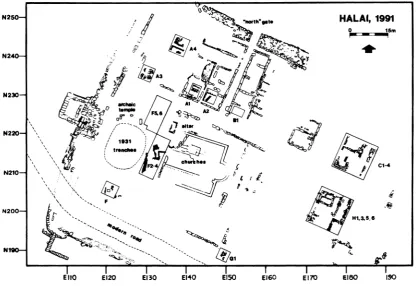
Excavation in 1990 and 1991 took place within the part of the acropolis of Halai set aside and fenced off by the Greek Archaeological Service (Fig. 3). For purposes of record- ing, this part of the acropolis has been divided into ten Areas designated A, B, C, etc. (Figs. 4, 5). 15 The excavation campaigns of both years were especially concerned with the earliest and latest occupations of the site, the Neolithic and the Late Roman/Early Byzan- tine. The 1991 excavations also focused on the remains of the Archaic period (Area A) and, to a lesser extent, on those of the Hellenistic period.16
14 Goldman 1915, no. 3, pp. 444-45 1.
15 The fence follows roughly the outer line of these Areas as shown in Figure 4. The southwest side of the
acropolis cannot be fenced off at present because of the need to maintain the modern road. At high tide the lowest courses of the fortification wall on the southwest side are below sea level.
16 Excavations in 1990 took place from July 2 until August 10. The week of July 2-6 was devoted to clean-
ing and preparation, and actual excavation took place for five weeks from July 9-August 10. In general, four trenches were under excavation at any time, and a maximum of ten local workers (including two potwashers) was employed.
The major excavations of 1991 took place during a six-week campaign from May 20 to June 28, with supplementary work in Area F during the following week. A maximum of thirteen local workers (including three potwashers) was generally employed.
?110 ? 120 E130 E140 E150 EO ?6 E170 EISO ?190 E200 E210 ?220 ?230 ?240 ?250 ?260
HALAI ACROPOLIS N6
0 Ism
N240 / N240
N230 23B
N220-- I.! ~~~~~~~~~~~~~~~~~~~~~~~~~~~~~~~~~~~~~~~~~~220
N200 N200
Ni H7'~ /N19
N18048
?710 ?N0?3 I4 90 ?6 ?7 10 E70?0 ZO 20 ?3 24 20 ?5
N250 HALAI, 1991
N24 *
N230
D
uch~~~~c
~Al
~~~~~~~
N220 EEl
1931 s
N210 - ~/ t
N200
11, 3 ,5 6
Ni~~~E1 E 120 El 30 E140 - E150 E160 E 170 gi8o 190
FIG. 5. Plan of northwestern part of the acropolis showing excavated trenches
Registrar; Nancy Cooper, Architect (1990); Leslie N. Hammond, Architectural Assistant (1990) and Archi- tect (1991); Andrew Heafitz, Balloon Photography; John A. Maseman (1990, before actual excavation be- gan), Conservator; Melodie Domurad (1991), Kerill O'Neill (1991), Demetris E. Sagias, Clark A. Walz (1990), Theodore Wygant (1991), and Sylvia Yu (1991), Trench Supervisors; Carlos Alvarenga (1991), Photographer; Damian Carr (1991), Drawing of Finds; Curtis L. Ellett (1991), Geology; Matthew J. Footer
(1990), Photographer; Cheryl Haldane (1990) and Julie K. Near (1991), Flotation; Patricia Merkley (1990),
Geology; Amanda Sutherland (1990), Conservator; Martha Demas (1991), Site Conservation. They were assisted by Magnus A. Sigurdsson and Theodore Wygant, who served as volunteers in 1990, and by H. Lyn Hardman, Michael F. Lane, Ann Merriman, Melissa Moore, Eva Nagy, William Parkinson, Melanie Pomeroy, Julia F. Rounds, Alison Sandman, Chikako Sugaya, Rozana N. Tsiknaki, Valerie Woelfel, and Patricia S. Wren, who served as volunteers in 1991. Michele Diamond served as Camp Manager for parts of both seasons.
The following student-trainees (from Cornell University, unless otherwise noted) also participated. 1990: Scott S. Johnson (currently at Grinnell College), Selina Kell (teacher at South Windsor High School), Christine Latini, Dana Liu, Stacey A. Major (Georgetown University), Nelson Morris, Dawn M. Mulhern, Julie K. Near, Barbara A. Olsen, Ann Pizer (Tufts University), and Sylvia Yu. 1991: Jonathan Alcantara, Amy M. Bogaard (Bryn Mawr College), Jason E. Bruder (Syracuse University), Ariel Cannon (New Col- lege, South Florida), Eleni Chiotelis (Vassar College), Jim Christie, Jason H. Coleman (New College, South Florida), Peter De Staebler (Bowdoin College), Tamara M. Highsmith, Damian P. Manolis, Eric A. Nord- gren (McGill University), and Ian Phair.
EXCAVATIONS AT HALAI, 1990-1991 273
THE NEOLITHIC PERIOD
Test trenches were excavated in Areas A, B, F, G, and H in order to determine the limits of the Neolithic mound which underlies the classical and later remains. Besides the trenches in Area F (see below), Neolithic strata were encountered in trenches A2, A4, B1, HI, and H4 (Fig. 5). Trench H2, excavated to stereo, produced no Neolithic remains, nor did trench G 1, the lowest level of which was at or near stereo at the end of the 1991 digging. In general, the trenches so far excavated suggest that the Neolithic settlement extended at least sixty meters northwest-southeast (from Area F to Area H) and at least forty meters northeast-southwest (from Area A to Area F) but that it may not have extended so far toward the southwest as the later acropolis.
Where Neolithic deposits have been encountered, they immediately underlie deposits of the Archaic period or later, and the uppermost Neolithic layers usually contain many small worn sherds, suggesting that there was a long hiatus during which the site was abandoned. To date we have found not a single recognizable Bronze Age sherd at Halai, either in the surface survey or during excavation. The report of Simpson and Dickinson of the existence of Bronze Age material is therefore almost certainly erroneous. 17
The Neolithic deposits are most accessible in the temple area (Area F) at the northwest side of the site, because the earlier excavations removed later deposits from above the Neo- lithic levels. Before the current excavations began, two pits from the earlier excavations passing through the Neolithic deposits were visible (Fig. 5; see P1. 69:b): a larger one near the center of the temple area, south of the foundations of the Archaic temple, which repre- sents the combined trenches excavated on behalf of Goldman by Grace in 1931 (not yet reexcavated), and a smaller one (now Trench F3) immediately adjacent to the southwest corner of the large church, about which we have found no records.
By the end of the 1991 season three trenches (F2-F4) had been combined to form an area of ca. 44 sq. m., and two others (F5 and F6) had also been combined to form a further area of ca. 32 sq. m. (Fig. 5).
Trench F3, at the southernmost end of combined trenches F2-F4, has been cleared almost completely to bedrock, which was encountered at 0.74 m. above sea level. Several cuttings are visible in the bedrock (P1. 70:a). Most of the deposit was debris that has fallen in since the earlier excavations, but in the lowest 0.20-0.30 m. some undisturbed deposit was encountered containing pottery of Early Neolithic types ("Rainbow" ware; Early Neo- lithic Black Burnished ware).
Elsewhere in combined trenches F2-F4 we encountered what we take to be domestic architectural remains representing several building phases and, set against the outer side of one wall, the stone-built base of an oven or hearth (P1. 70:b). Around the oven is an ashy deposit. The pottery associated with these remains can be dated not later than an early stage of the Late Neolithic period. Deeper ashy deposits that predate the extant hearth are prob- ably to be dated to a late stage of the Middle Neolithic, although the pottery has yet to be examined in detail.
'7 Simpson and Dickinson 1979, p. 262, G 69; the references they give do not, in fact, make any mention of
The pottery from Late Neolithic levels in trenches F2-F4 includes Black Burnished wares like those of the Tsangli-Larissa phase in Thessaly, Matt Painted wares, and red-on- white painted pottery like that from Elateia.18 A few sherds of coarse paste with white-filled incised and punctated decoration have their closest parallels with finds from a cave at Tha- rounia in Euboia.19
Trench F5, to the north of F2 and immediately between the foundations of the Archaic temple and the Archaic altar, passed through 0.05 m. of mixed Archaic-Neolithic deposit to reach the top of a puzzling scatter of small stones (P1. 70:c). The stones fall within a band
ca. 3 m. in width extending east-west from one scarp of the trench to the other. The top of the band is generally higher toward the center than at the edges. We are as yet uncertain whether this band of stones was a deliberate structure (perhaps the base of boundary wall?) or whether it is simply the result of post-Neolithic erosion.
Stone-built walls of Neolithic date were also encountered beneath the Archaic levels in Area A, trench A2 (Fig. 5, P1. 71:d) and beneath Hellenistic levels in Area H, trench HI (Fig. 5, P1. 73:b, indicated by arrow). Until the pottery from these trenches is studied fur- ther, these walls cannot be assigned to particular phases of the Neolithic era.
All soil from Neolithic deposits is being water sieved under the supervision of Julie Near. Although detailed analysis of the botanical finds has yet to be carried out, preliminary examination suggests that the crops produced by the inhabitants of Neolithic Halai were similar to those of other contemporary communities.
Obsidian is abundant in Neolithic levels and was clearly worked at the site; chert also occurs in smaller quantity (see Appendix 1, p. 278). Other finds include fragments of terra- cotta figurines (P1. 70:d: A, seated female; B, face, possibly of an animal; C, D, human lower legs); pierced shells probably from a necklace (P1. 70:d, E); and stone celts (P1. 70:d, F, G). The heavy fraction from flotation includes many tiny stone beads in a variety of materials and shapes. To date, no prehistoric material that dates later than the LN I phase has been recognized in survey or excavation. We expect to collect samples for radiocarbon dating in the 1992 season.
THE ARCHAIC PERIOD
Excavations in trench F6, immediately adjacent to the northeast side of F5, showed that the street that bisects the acropolis from northwest to southeast was already in existence in Archaic times. The earlier excavations had revealed the Archaic temple and altar on the southwest side of the street (Area F) but did not penetrate as deeply as the Archaic levels on the northeast side of the street (Area A). It was therefore with great anticipation that we opened up four new trenches in Area A (A1-A4; Fig. 5).
Structures of the Archaic period were revealed in all four trenches. In A3 (P1. 71:a), which measured 4 x 4 m., a stone wall socle appeared with one course of mud bricks still
in situ. The wall is probably that of a house. To the southwest, between this wall and the
18 It can all be assigned to an early stage of the LN I phase as I have defined it (Coleman 1987; Coleman,
forthcoming).
EXCAVATIONS AT HALAI, 1990-1991 275
probable line of the street, i.e., outside the house, four round platformlike structures were encountered. That to the left in Plate 71:a is partly surrounded by flat stones set on edge creating a shallow channel. The use of the platformlike structures is not yet clear, although it is possible that they were granaries, given their resemblance to similar structures found in Geometric levels at Lefkandi.20
Trench A4 revealed part of another Archaic house, perhaps of megaron plan, and a building adjacent to it, the plan of which is difficult to interpret (P1. 72:a).
Trenches Al and A2 were tests beneath the floors of the rooms of the westernmost of the two large "North gate buildings" constructed probably in the 4th century B.C. (P1. 71 :b). In
trench Al a pavement, a wall, a probable drain, and part of a mud-brick construction came to light (P1. 71:c). In nearby trench A2 the corner of a lightly built structure was excavated (P1. 71:d). Its walls are made of unworked stones, set on edge to form the inner face. A rectangular slab placed on end was found within the structure and probably dates to the period of its use. The character of these remains is not yet clear. The pottery associated with them, while not plentiful, appears to date to the 6th century B.C.
It is notable that all the Archaic structures excavated in Area A are similarly aligned and that this alignment corresponds generally to that of the fortification walls and the main northwest-southeast street. The Archaic temple in Area F, on the other hand, is oriented almost exactly east-west and is thus on a slightly different alignment, although the altar to its east more nearly lines up with the rest of the Archaic structures. The evidence so far available suggests that there was a substantial community in the Archaic period within the acropolis at Halai. How densely packed the acropolis was with buildings, whether it was laid out on a strict grid plan, and whether it contained public buildings other than the temple are questions we hope to examine in future seasons.
In the upper levels of trench F6 scattered debris was found corresponding to levels ascribed by the earlier excavators to the "first temple area".21 Pieces of bronze jewelry and votive pottery were found within this debris, including a black-figured skyphos adorned with a variety of animals and with potter's and painter's signatures (P1. 72:b)22 and a frag- ment of about one-half of a capital from the earliest Archaic temple, which joined with its other half, excavated by the Goldman expedition and left at the site.23
Undisturbed levels of the Classical period (480-323 B.C.) have not yet been distin-
guished by our expedition anywhere on the acropolis at Halai. Although we know from tombs and other evidence that the town was occupied in this period, it is possible that the acropolis itself was devoted to official activities which have left no trace. Or possibly the remains of Classical habitation on the acropolis were almost completely obliterated by later buildings. It is hoped that future seasons will produce more evidence on this point.
20 Popham et al. 1979 and 1980, pp. 24-25 and pls. 5, 6:c, 7, 8:b. Thanks to William Coulson for pointing
out this parallel to us.
21 Goldman 1940, pp. 397-430.
22 The animals include a panther, a dolphin, a scorpion, probably a dog and a rabbit, and a snake. The
potter's signature reads 'E7roT0E'g E7roL'Eo-[E]. The painter's reads Ev'pa[. . . ]v f`Kpaw-rE. Note the misspell-
ing (kappa for gamma) of fKpao/fE.
23 Cf. Goldman 1940, figs. 30, 33. On p. 401 she mentions three examples of the type, "one about half
THE HELLENISTIC PERIOD
In the later 4th century B.C., the fortification walls of the acropolis were renovated and expanded, especially in the eastern corner around the "northeast" gate. Then, or perhaps somewhat later, a round tower was added at the south side of the gate (Fig. 3, P1. 74:d), pre- sumably to make the town ever more secure from attack. Halai clearly flourished in the suc- ceeding centuries, as the inscription already mentioned and the multiplicity of walls and buildings excavated by our predecessors (but hardly mentioned in their notebooks) make clear.
A major effort is being made to excavate a substantial area of the ancient town un- touched by the earlier excavators. We have chosen to concentrate at a point near the center of the site within Areas C and H. These Areas straddle the main ancient northwest- southeast street which bisected the site. Four initial 4 x 4 m. trenches in each Area will, when the baulks are completely removed, form larger squares 9 m. on a side, and the grid pattern will eventually be extended to excavate the street itself (Fig. 5, P1. 72:d).
The upper levels of most of the structures so far cleared in Areas C and H belong to the Roman period. Lower levels, on the other hand, can be dated by pottery and lamps to the Hellenistic era. Little can be said about the Hellenistic structures, since they have not yet been extensively investigated. In general, however, they appear to be of the same character and to have the same orientation as those of the Archaic period (see above) and the Roman period (see below). In some instances the lower parts of Hellenistic walls probably served as foundations for Roman buildings. The evidence thus suggests that the Hellenistic town was essentially similar to the Roman one. The general alignment in both periods continues that of the Archaic period.
Beneath fallen roof tiles (P1. 73:c) at the southeast side of Room 3 in Area H (trenches H1 and H5; P1. 73:a), a deposit of pottery and objects was found which may be dated to the late 2nd or early 1st century B.C. The deposit includes terracotta lamps (P1. 74:a, top row), a side-spouted vessel (P1. 74:b), and many terracotta loomweights. A fall of similar tiles in Area C may be about the same date. Perhaps the collapses of roofs that these remains attest may be connected with the destruction of the town by Sulla in 85 B.C. mentioned by Plutarch (Sulla 26), although this can only be a very tentative hypothesis until further excavation has taken place.24
THE ROMAN PERIOD
The Roman period, like the Hellenistic, was mostly investigated in Areas C and H. Details of the external boundaries of the buildings excavated (Fig. 5, P1. 72:d) and of their internal division are so far only tentative. The general situation, a sequence of houses front- ing on the main northwest-southeast street, is complicated by the probable existence during the middle phases of Roman occupation of a cross street that passes on one side of the main street through trenches C3 and C4 and on the other side through trenches H5 and H6. The situation at the crossroads, i.e., between C4 and H5, is still obscure.
EXCAVATIONS AT HALAI, 1990-1991 277
The existence of the main northwest-southeast street is attested in trench C2, where the street was bounded by a line of stones probably representing a curb (P1. 73:d). The cross street is best attested by similar lines of stones passing through trenches C3 and C4 (P1. 72:d) and through trench H5 and the area of the former baulk between H5 and H6 (P1. 73:a; a later wall is built over part of this curb in H5). That this cross street had at least partly gone out of use before the end of occupation in Area H is attested by the existence of the corner of a building in trench H6, at a higher level than and blocking the cross street (P1. 73:a, lower left).
The houses of the Roman period were divided into several rooms and were built from a great variety of material, including many ashlar blocks reused from earlier structures. The finds, though scanty, attest to their domestic character. A basin, mortar, and grindstone were found in situ in a good state of preservation in trench C3 ext (P1. 72:d, during exca- vation; P1. 72:c, after cleaning).
Pottery and lamps (e.g., P1. 74:a, bottom row) associated with the houses may be dated to all three Roman stages, Early (31 B.C. to A.D. 150), Middle (150-350), and Late (350-650), although remains of Middle Roman are as yet scanty. The latest datable mate- rial firmly associated with the Roman houses is probably of the 6th century, after which the town may have been abandoned.25
Although no excavation has yet taken place in the larger "square" church in Area G (Fig. 5, P1. 69:b), it is likely to have been in existence during the time of the latest Roman occupation of the town. How long it continued in use is not clear (perhaps it was abandoned at the same time as the town), but it was eventually replaced by a smaller church built over its ruins, probably in the 12th or 13th century. Two tile-covered graves excavated in the upper levels of trenches A4 and H5, and others like them cleared by the earlier expedition, cannot be closely dated but were probably dug after the abandonment of the town.
JOHN E. COLEMAN
CORNELL UNIVERSITY
CHELP
Goldwin Smith Hall Ithaca, NY 14853-3201
APPENDIX 1: NEOLITHIC CHIPPED STONE
This brief report26 is intended to provide a preliminary overview of the material re- covered so far. Although the material is here described as a group, it comes from several different trenches spread over the site. The great majority of the pieces, however, come from five trenches situated close together in Area F (A1-A5). Until the pottery is analyzed in greater detail, individual chipped stone pieces cannot be firmly placed within a chrono- logical phase. All probably date no later than the abandonment of the Neolithic town early in the LN I phase, and almost all probably fall in general terms within the span of late MN and early LN.
During the first two seasons of excavation, 891 pieces were collected, of which 312 were found in the course of digging and 579 were separated from the heavy fraction left after the excavated soil had been passed through a flotation system. Thus 65 percent of the Halai chipped-stone assemblage was recovered only by means of water-sieving the excavated soil. All the excavated soil from Area F, as well as control units from the other areas, was water- sieved. This process has made possible the recovery of tiny pieces of chipped stone, as well as flake and blade fragments and, occasionally, complete artifacts.
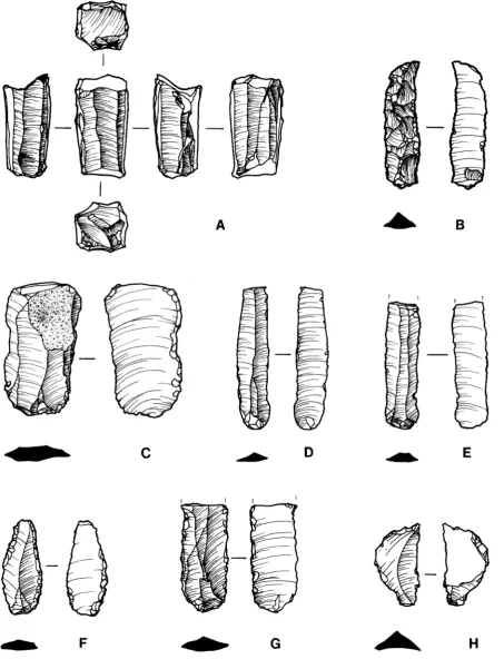
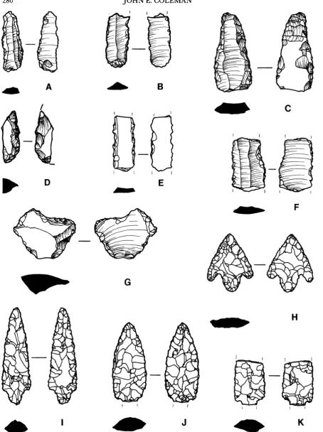
Obsidian accounts for 94 percent of the pieces; chert makes up the remaining 6 per- cent.27 While none of the obsidian has as yet been subjected to characterization studies, all the pieces examined so far conform with the visual characteristics of Melian obsidian. The chert pieces vary widely in color, texture, and quality. We have yet to identify any local sources for workable chert. Ninety-two pieces, 10.3 percent of the collection, are blades or tools. The presence of two cores (Fig. 6:A) and four crested blades (Fig. 6:B) gives evidence that nodules were worked at this site. There are also three platform removals and a number of cortical flakes.
The great majority of diagnostic chipped-stone pieces examined so far appear to be of Late Neolithic character.28 This preponderance of Late Neolithic artifacts would appear to tally with the preliminary analyses of the pottery. There is only one percussion blade (Fig. 6:C); the rest are pressure-flaked and parallel sided. Proximal dorsal trim is very common (Fig. 6:D, E). There are many retouched pieces, i.e., blades and flakes modified by discontinuous or continuous retouch, including those modified by use-retouch or use-wear only (Figs. 6:F-H, 7:A-C).29 One artifact appears to be a pointed piece; both ends come to a point, and one end appears to have traces of crushing and rounding from use as a drill or piercing tool (Fig. 7:D).30
Only one piece that resembles a sickle element has been identified (Fig. 7:E). No mi- croscopic analysis, however, has yet been performed on this or any other piece to detect traces of silica gloss. The dearth of sickle elements is perhaps due to the location of the
26 Thanks are due to Damian Carr who provided the illustrations for this report.
27 These percentages of obsidian and chert match those of the EH II site at Lerna almost exactly: 94.2 per-
cent obsidian to 5.8 percent chert. Cf. Runnels 1985.
28 For a description of tools and blades typical of different periods, see Cherry and Torrence 1984.
29 This broad classification, described in Runnels 1985 (p. 370), is especially convenient for a preliminary
report. See also Perles 1981, pp. 192-193, fig. 124:3-5.
30 Cf. Perles 1981, p. 167, fig. 112:3. See also Evans and Renfrew 1968, pp. 51, 52, 60 (fig. 72:1-7; nose-
EXCAVATIONS AT HALAT, 1990-1991 279
@ ~~~A
_B
C
_D
_E
F
_G
_H
~A B
t_t X _~~~~~~~~~
^
_
~ J_K
EXCAVATIONS AT HALAI, 1990-1991 281
excavations within the Neolithic settlement and not out in the fields where these tools were used.3" There are two notched pieces in the assemblage, one made from a blade (Fig. 7:F), and the other from a flake (Fig. 7:G).32
By far the most highly worked tools in the assemblage are the projectile points. All four are barbed and tanged (although in two cases the tangs have been snapped off). One of the points is short and squat with sharply defined barbs (Fig. 7:H);33 the other three are longer and slimmer with modest barbs (Fig. 7:1-K).34 In one case (Fig. 7:K), only half of the point is preserved. It seems likely that the short and squat projectile point was fashioned either during a different period than the rest or for a different purpose.
Detailed analysis of the Halai chipped-stone assemblage is planned. Furthermore, ex- cavation of the earlier levels and the establishment of a chronological sequence should reveal more about the development of the lithic industry during the Neolithic period. Studies to date have shown that nodules were worked at Halai and that the small sample examined so far, which includes numerous tiny flakes, has a wide variety of types. Five different tool types are represented: retouched pieces, pointed pieces, sickle elements, notched pieces, and projectile points (and the classification "retouched pieces" is very broad and covers pieces with a variety of forms and functions). It is too soon to characterize the lithic industry at Halai, but the recovery of even the smallest chips should, after further study, make possible a detailed picture of chipped-stone tool production.
KERILL O'NEILL MELANIE POMEROY
31 No sickle elements were found at Saliagos. On the problematic identification of these tools, see Evans and
Renfrew 1968, p. 85.
32 Cf. Evans and Renfrew 1968, p. 60, figs. 72:8, 9,73:1-3. See also Perles 1981, pp. 165-167, fig. 111:9-11.
3 There are no exact parallels at Saliagos. While some of the points are as short and squat, only one comes
close to the sharply defined barbs of this example (Evans and Renfrew 1968, p. 58; fig. 66:1, 2 and fig. 65:11, respectively).
34 See Evans and Renfrew 1968, fig. 62:1, 2, 7, 8, 9. See also the barbed and tanged point from Paoura, on
APPENDIX 2: HELLENISTIC AND ROMAN POTTERY AND SMALL FINDS
This appendix presents a selection of the pottery and small finds from the later levels of the town within the acropolis walls at Halai. The excavations in these levels are described above (pp. 276-277).
HELLENISTIC
The finds included here come from beneath the fallen tiles at the southeast side of Room 3 (Area H), which are tentatively connected with the Sullan destruction of 85 B.C.
The finds from that context are consistent with such a date: they include 27 loomweights (e.g., 1), several lamps datable roughly between 100 B.C. and A.D. 50 (e.g., 2-5),35 and a spouted jug (6).
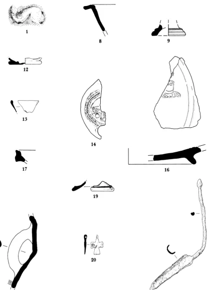
1. Stamped loomweight (H91-491)
Avg. Diam. 0.11, Th. 0.03 m. Coarse local fabric. Buff clay with large red, black, and white inclu- sions. Flat disk with two suspension holes and dolphin stamp (Fig. 8; L. 0.054 m.).
Goldman Type IIB (Goldman 1940, pp. 509-513), examples of which were found in contexts of "the end of the 3rd to the beginning of the 2nd century B.C." (p. 509); 1 is probably later. Goldman also mentions a possible example of a dolphin stamp from Halai (no. 39, p. 513) but without illustration.
2. Lamp (H91-473) P1. 74:a, B
Missing only vertical handle. L. 0.109, Diam. 0.06 m. Gray ware with few inclusions. Thin, me- tallic black slip. Wheelmade lamp with flat, plain bottom; globular body curves to plain disk with raised collar added separately. Central filling hole.
Close to Broneer Type XIX, no. 329, pp. 66-70, pl. 6 (ca. 100 B.C.-A.D. 50), although lacking the dec-
oration on the rim and with a rounded rather than triangular nozzle; Howland Type 37C, no. 504, p. 121, pls. 19, 45 (dated ca. 50 B.C.-A.D. 50), is also
similar, except for the ware.
3, 4. Lamps P1. 74:a, A and C
Similar to preceding.
5. Lamp (H91-469) P1. 74:a, D
Missing only vertical handle. L. 0.082, Diam. 0.039 m. Badly encrusted with lime, which pre- vents detection of glaze. Wheelmade lamp with ir- regular, slightly rounded bottom; sides curve to a flat sunken top.
Like Howland Type 35D, no. 484, p. 114, pls. 17, 43 (late 1st century B.C. to 1st century after Christ),
but the type begins as early as the 3rd century B.C.;
cf. Broneer Type XVI, no. 198, p. 56, pl. 5.
6. Spouted jug (H5b[15]92) P1. 74:b
Whole except for the broken spout. H. 0.15, Diam. of rim 0.12, Th. 0.003 m. Buff clay with gray-black slip. Badly encrusted with lime. Glob- ular body, raised ring base, flaring neck with molded rim. Single rounded handle curves from below rim to upper body. Strainer across bottom of neck, with five holes in quincunx pattern. This shape is found commonly from the 2nd cen-
tury B.C. onward: see, for example, Corinth VII, iii,
no. 778, p. 149, pls. 36, 64.
EARLY ROMAN
An important occupation in the 1st century after Christ can be confirmed from the ceramic evidence. There appears to be little or no chronological gap between the deposits of the Hellenistic and those of the Roman period. Among this 1st-century material is an abun- dance of imported pottery, including Pompeian Red Ware, Qandarli ware, and Eastern
EXCAVATIONS AT HALAI, 1990-1991 283
<~~~: 4UIII\
-ov~ ~ ~ ~ ~ ~ ~~~~~~
8 9
12
1
3
14
I...
_ _ __1 7 16
19
20
18 21
Sigillata B, indicating wide-ranging trade contacts throughout the Mediterranean area. Since these levels were not reached until the final weeks of excavation, only a small sample can be presented. The lst-century levels include many Broneer Type XIX lamps in addi- tion to the objects described below.
7. Lamp (H91-436) PI. 74:a, F
Area H, topsoil. Half of discus only. Diam. of dis- cus 0.074 m. Discus shows a pattern of tongues forming a rosette.
Like Broneer Type XXI, no. 393, pp. 73-76, pl. 7 (late 1 st century B.C. to late 1 st century after Christ).
8. Bowl rim (Hlb[40]157) Fig. 8
Floor of Area H, Room 3. P.H. 0.04, est. Diam. 0.16 m. Dark orange-red clay with good quality, darker, browner glaze. Wide, everted, level rim. No decoration.
Possibly imitation Samian ware. Resembles Agora V, no. G 21, p. 25, pls. 4, 57, 62, 73. Robinson dates this form to the first half of the 1 st century after Christ.
9. Cup base (Hlb[40]157) Fig. 8
Floor of Area H, Room 3. Base only. P.H. 0.016, Diam. of base 0.045 m. Dark pinkish clay with darker orange-red glaze. Hemispherical cup. Similar to Agora V, no. G 73, p. 29, pls. 5, 66. Date as preceding.
MIDDLE ROMAN
At the end of the 1st century after Christ, Halai seems to decline in importance. There is some 2nd- and 3rd-century material but as yet in much smaller quantities and unevenly distributed. 11 is one of several 3rd-century amphora handles found in Area C.
10. Lamp (H90-11) P1. 74:a, H
Fill over Area H, Room 3. Only the handle pre- served. P.H. 0.041 m. Buff clay, unglazed. Like Broneer Type XXVII, no. 556, pp. 90-102, pl. 1 1, of Corinthian manufacture. The type starts in the late 1st century after Christ and reaches its height in the Hadrianic period.
11. Amphora handle (Cla[7]91)
Floor(?) of Area C, Room 1. Coarse, brick-red clay with white lime inclusions. Eroded, perhaps by later use as a tool. Heavy, thick, straight han- dle, ovoid in section, with shallow vertical fluting. Similar to Agora V, no. K 113, p. 69, pl. 15. The Athens amphora comes from a sealed deposit of the first half of the 3rd century. Although this shape is more common in the 4th century and continues into the early 5th, the 3rd-century date seems more likely for our piece. None of the later examples from the
Agora have fluting on the handles, and no defi- nite 4th-century material has yet been discovered at Halai.
12. Glass beaker (H90-207) Fig. 8
Floor(?) of Area C, Room 1. Base only preserved. P.H. 0.009, est. Diam. of base 0.044 m. Milky, semiopaque, pale blue. Heavy, disklike base with body widening upward.
Similar to Agora V, no. M 105, p. 94, pl. 55 (second half of 2nd century after Christ).
13. Glass beaker (H90-181c) Fig. 8
Fill of Area H, Room 3. Fragment of rim. P.H. 0.017, est. Diam. of rim 0.08 m. Transparent, pale bluish green. Rim rounded off, with thicken- ing on inside.
EXCAVATIONS AT HALAI, 1990-1991 285
LATE ROMAN
There is as yet no ceramic evidence from the excavations for settlement at Halai in either the 4th or the 5th century. In the 6th century the town enjoyed a renaissance, possibly to be associated with Justinian's reconquest of the Mediterranean ca. A.D. 535-550. Sixth- century Halai seems to have been a thriving metropolis, with imported amphoras and African Red Slip plates which indicate considerable trade with the whole Mediterranean area. The large Christian basilica in Area G, which has not yet been excavated, was proba- bly constructed in the 6th century.
14. Lamp (H90-338) Fig. 8, P1. 74:a, G
Fill over Area H, Room 3. Half of the top is pre- served lengthwise; handle broken off. P.L. 0.085, p.W. 0.035, Diam. of discus 0.044 m. Reddish brown clay with no visible inclusions. Ovoid, ta- pering slightly toward the round filling hole. Cir- cular discus holds cross with slightly flaring bars. Small double circles around and inside the cross. Rim: double raised palm-branch pattern continu- ing around past nozzle. Base of vertical handle. Close to Agora VII, no. 2544, p. 182, pl. 40 (6th cen- tury after Christ). Also like Corinth IV, ii, nos. 1456, 1489, pp. 118-119, pl. 22 (Broneer Type XXXI, which begins in the late 4th century after Christ and does not outlast the 6th at Corinth).
15. Lamp (H190-70) P1. 74:a, E
Fill over Area H, Room 3. In two pieces; missing front part and nozzle. P.L. 0.096, W. 0.076, Diam. of discus 0.062 m. Bright red clay with no visible inclusions. Large, unpierced vertical handle. Like Corinth IV, ii, no. 1482, pp. 118-119, pl. 22 (Broneer Type XXXI) but with a single filling hole at rear of discus. Row of concentric circles on the rim; an indistinct design on the discus. Raised circle with many smaller circles inside on the base. Date as above.
16. . Dish (H6 b[14]96) Fig. 8
Lower street level outside Area C, Room 5. Part of base preserved. Est. Diam. of base 0.095, Th. 0.008 m. African Red Slip. Orange-red clay with no visible inclusions; glossy though thin light- orange slip. Large dish or bowl with sloping floor. Foot of medium height, flaring at top. Hayes 1972,
Form 104, pp. 160-166 (A.D. 530-580). Two
grooves around floor.
Stamped decoration in center shows male frontal bust (a saint?) similar to Hayes 1972, stamp type 234 (around second quarter of 6th century) but lack- ing body below shoulders, and with no nose or mouth. The drapery is closer to Hayes 1972, type 245. The stamp is off-center and must have been ac- companied by another bust on the other side. Over the top of the head is part of another stamp, possibly Hayes 1972, type 78.
17. Dish or bowl (H5 b[8]43) Fig. 8
Lower portion of fill over Area C, Room 3. Est. Diam. 0.28 m. Fragment of rim. Dark reddish clay with slightly darker, very thin slip. Late Ro- man C ware. Vertical rim incorporates a flange. Parallels: Hayes 1972, Form 3F, no. 25 (Athens,
Agora P 26088), pp. 333-338 (ca. A.D. 525-550).
18. Amphora (H4 a[2]2) Fig. 8
Area H, topsoil. Only handle and part of body preserved. P.H. 0.19, Diam. of handle 0.037 m. Gritty buff clay. Upper body plain; below the handle is closely spaced ridging. The thick, sag- ging handle is ovoid in section. These ridged am- phoras are common at Halai in all 6th-century contexts.
Similar to Riley n.d., no. 347, Late Roman Ampho- ra Type la, pp. 212-216, fig. 91. Riley dates this type between the 6th and the mid-7th centuries after Christ. It has a wide distribution and is common at Athens, possibly originating in the Antioch region.
19. Glass goblet base (H90-218b) Fig. 8
Many examples of this type have been found at Halai. Others have the thin stem preserved. Closely resembles Hayes 1975, no. 653, p. 158, fig. 11 and Agora V, no. M 342, p. 116, pl. 54 (early 6th cen- tury). Hayes sees the narrow stem as suggesting a date in the 6th or early 7th century after Christ. No "wine-glasses" occur at any site before the late 5th century.
20. Copper-alloy cross (H91-558) Fig. 8
Fill over street in Area H. H. 0.028, W. 0.018 m. Considerable corrosion. Bars flare slightly toward
ends, except top bar which tapers to a pierced hole for hanging, perpendicular to the cross itself. The cross is decorated on one side with three raised double circles, each with a tiny inner circle. Re- verse plain.
21. Copper-alloy spatula (H90-31 1) Fig. 8
Fill over street in Area H. L. 0.195, L. of blade 0.074, W. of blade 0.012 m. Relatively little corro- sion. Blade U-shaped in cross section with pointed tip. Handle circular in section with groove run- ning down its length; handle ends in ovoid nodule.
None of the finds postdate the 6th or very early 7th century after Christ except a few iso- lated sherds of mediaeval lead-glazed pottery, probably to be associated with the construction of the smaller church inside the ruin of the 6th-century basilica. Therefore the smaller church was probably not associated with a resettlement of the town of Halai. Further de- tailed study of the ceramics is underway to compare the trenches and areas and to relate the site as a whole to other excavated sites in Greece. This study will compare the ratio of fine wares to coarse wares in each context, the proportion of imported pottery and amphoras in each period, and so forth, and will, it is hoped, eventually lead to a much-needed chronology of the local coarse wares. Preliminary results suggest a higher proportion of coarse wares in Area H than in Area C, but until further excavation and stratigraphic analysis take place, this must be regarded as only a tentative hypothesis.
EXCAVATIONS AT HALAI, 1990-1991 287
APPENDIX 3: BALLOON PHOTOGRAPHY
Aerial photography of archaeological sites from tethered balloons is a reliable, practical, and cost-effective means of obtaining a perspective not otherwise possible.36 Pioneering work has been done in Greece by Wilson and Eleanor Myers.37 One aim of the CHELP project is to develop further the techniques of balloon photography and to apply it to the detailed daily recording of an excavation in progress. We have been especially concerned with mechanisms for aiming the camera accurately; the video-camera downlink developed in this project has not yet, to the best of my knowledge, been used elsewhere for archaeo- logical purposes.
Balloon photography was used at Halai during both the survey of the site in 1989 and the digging seasons of 1990 and 1991. The original system used during the 1989 survey season consisted of a 35 mm. camera lifted into the air by a spherical tethered balloon three meters in diameter. The camera was suspended from the rigging underneath the balloon in such a way that it always pointed straight down. The balloon was moved over its target area by tethers, and pictures were taken by remote control. Although the photographs obtained with this system were satisfactory, the camera operator did not have much control over what was included in each photograph. Also, there was always doubt that the camera had actu- ally taken a photograph, once it was too high for its shutter and motor drive to be heard from the ground.
To overcome these shortcomings, a new platform was constructed for the 1990 digging season. The same spherical balloon was used: although the shape is not so aerodynamic as a blimp-shaped balloon, it is more compact, takes less gas to inflate, and is easier to handle when inflated but still on the ground. The small size also makes it possible to inflate the balloon on the deck of a ship and to fly it from a small motor or row boat. The whole aerial photography system, including the balloon, can be carried on an airplane and transported to the site in a suitcase.
The new camera platform used in 1990 and 1991 (P1. 74:c) represents a considerable advance over the initial system. The camera, instead of simply hanging from the rigging of the balloon, is mounted inside a stabilized, two-axis, powered gimbal mount constructed of nomex honeycomb fiberglass. The outer section of the mount isolates the gimbals from the motion of the balloon. The inner gimbals are powered in the elevation and azimuth axes by two small servo motors operated from the ground by radio control; hence the operator can aim the camera in any direction from parallel with to perpendicular to the horizon and can rotate it a full 360 degrees in the horizontal plane. A video camera is mounted in tandem with the still camera, and its signal, in addition to being recorded on videotape on board, is transmitted to the ground by a video downlink. The video signal can thus be displayed on a three-inch color monitor in real time so that the operator can see exactly the same view as the still camera. Consequently, both cameras can be aimed with great precision.
The camera control panel on the ground has two joysticks, one to aim the cameras, the other to activate the shutter of the still camera, resulting in still pictures which exactly
36 See, e.g., Myers and Myers 1980; Noli 1985.
37 See, e.g., Myers and Myers 1990; Myers, Myers, and Cadogan 1992. I should like to thank the Myers
match the scene displayed on the monitor. The exposure of the picture is determined by an automatic exposure mode on the camera, and the lens is focused at infinity. Since great depths of field are not generally necessary, fast shutter speeds can be used in order to minimize the effects of any motion imparted to the camera from the motion of the balloon or its tether lines. The video downlink is invaluable; not only does it provide for aiming the cameras and indicate when they are perfectly still but its audio track also confirms that a photograph has actually been taken by the still camera. Both the camera shutter and the sound of the motor drive reaching the end of the roll of film can be heard, so that problems can quickly be identified, saving time and film.
The video tape also provides an instant record of each flight. It can be reviewed either on the control-panel monitor immediately after the balloon is hauled down or at any later time, and it shows exactly what was in the field of view when each picture was taken. Film, by contrast, requires processing and cannot be viewed without some delay.
A prime mission for balloon photography at Halai is photographic documentation of the progress of the excavations at a finer level than is possible by means of architectural plans. During the 1991 season, the balloon was flown an average of 4 out of 5 workdays every week. Each trench was regularly photographed from altitudes ranging from 4 m. (e.g., P1. 72:a) to 40 m. (e.g., P1. 72:d). Other photographs taken from altitudes of 100 m. or more cover much or all of the acropolis (e.g., P1. 69). This versatility makes it possible to maintain a photographic record which can show features ranging in size from 1 millimeter to over 100 meters across. The video monitor also makes it easier to create complex photo mosaics covering more ground than can be captured in a single picture. Balloon pho- tography is also helping to document features in the shallow water adjacent to the acropolis. The series of aerial photographs for each trench may also be used in conjunction with regu- lar architectural plans to create phase drawings, i.e., plan views over time. When drawn on transparent mylar, such drawings can overlie one another to show a sequence of features and artifacts over time, whether in order of their discovery or of their actual use in ancient times. Aerial photographs can also be developed and printed overnight and can be distrib- uted the next day for use as an up-to-date reference in documenting new finds.
In future seasons we plan to substitute a medium format camera for the 35 mm. camera for better photographic resolution. We also hope to put into use a system of photogram- metry, whereby plans can be generated directly from aerial photographs. It may also be possible to link such plans electronically with the computerized database of finds so that architectural features and finds can be represented graphically in three dimensions, either on a computer monitor or as drawn out by a plotter.
EXCAVATIONS AT HALAI, 1990-1991 289
BIBLIOGRAPHY
Agora IV = R. H. Howland, Greek Lamps and Their Survivals (Agora IV), Princeton 1958 Agora V = H. S. Robinson, Pottery of the Roman Period: Chronology (Agora V), Princeton 1959 Agora VII =J. Perlzweig, Lamps of the Roman Period (Agora VII), Princeton 1961
Cherry, J. F., and R. Torrence. 1984. "The Typology and Chronology of Chipped Stone Assemblages in the
Prehistoric Cyclades," in The Prehistoric Cyclades, J. A. MacGillivray and R. N. L. Barber, eds.,
Edinburgh, pp. 12-25
Coleman, J. E. 1987. "The Late Neolithic Period: Questions of Terminology and Chronology" (paper, Sixth
International Colloquium on Aegean Prehistory, Athens, September 1987)
. Forthcoming. "Greece and the Aegean," chap. 11 in Chronologies in Old World Archaeology, 3rd ed.,
R. W. Ehrich, ed., Chicago
Corinth IV, ii = 0. Broneer, Terracotta Lamps (Corinth IV, ii), Cambridge, Mass. 1930
Corinth VII, iii = G. R. Edwards, Corinthian Hellenistic Pottery (Corinth VII, iii), Princeton 1975
Evans, J. D., and C. Renfrew. 1968. Excavations at Saliagos, Oxford
Fossey, J. 1990. The Ancient Topography of Opuntian Lokris, Amsterdam
Goldman, H. 1915. "Inscriptions from the Acropolis of Halae," AJA 19, pp. 438-453
1916. "The Terracottas from the Necropolis of Halae" (diss. Radcliffe College 1916)
1930. "Some Votive Offerings from the Acropolis of Halae," in Festschriftfiur James Loeb, F. Bruck- mann, ed., Munich, pp. 67-72
. 1940. "The Acropolis of Halae," Hesperia 9, pp. 381-514
Goldman, H., and F. Jones. 1942. "Terracottas from the Necropolis of Halae," Hesperia 11, pp. 365-421
Hayes, J. 1972. Late Roman Pottery. London
. 1975. Roman and Pre-Roman Glass in the Royal Ontario Museum: A Catalogue, Toronto
Keos I = J. E. Coleman, Kephala (Keos I), Princeton 1977
Myers, J. W., and E. E. Myers. 1980. "The Art of Flying: Balloon Archaeology," Archaeology 33, pp. 33-40
. 1990. "Low Altitude Aerial Photography in Crete," Expedition 32, pp. 31-33
Myers, Myers, and Cadogan 1992 - The Aerial Atlas of Ancient Crete, J. W. Myers, E. E. Myers, and G. Cadogan, eds., Berkeley
Noli, 0. 1985. "Low Altitude Photography from a Tethered Balloon," JFA 12, pp. 497-501
Perles, C. 1981. "Industries lithiques," in La grotte prehistorique de Kitsos (Attique), N. Lambert, ed., Paris,
pp. 129-222
Popham, Sackett, and Themelis 1979, 1980 = Lefkandi I (BSA, Supplement 11), M. R. Popham, L. H.
Sackett, and P. G. Themelis, eds., Oxford
Riley, J. N.d. "Coarse Pottery," in Excavations at Sidi Khrebish, Benghazi (Berenice) (LibAnt V, Supple-
ment 2), Tripoli
Runnels, C. N. 1985. "The Bronze Age Flaked Stone Industries from Lerna: A Preliminary Report," Hes- peria 54, pp. 358-360
Simpson, R. H., and 0. T. P. K. Dickinson. 1979. A Gazetteer of Aegean Civilization in the Bronze Age, I, The Mainland and Islands (SIMA 52), Goteborg
Walker, A. L. 1916. "The Pottery of the Necropolis of Locrian Halae" (diss. University of California, Berke- ley 1916)
1~~~~~~~~~~~~~~~~~~~~~~~~I6 -5
I'
^, ~~~~j #.t8'r22' .
a. Balloon view of acropolis of Halai looking northwest (1991)
b. Northwest end of acropolis (1991). Balloon view, north at upper right
*-; Po-
lw ~~~ ~~~ ~~~ ~~~ ~~~ ~~~ ~~~ ~~~ ~~~ ~~~ ~~~ ~~~ ~~~ ~~~ ~~~ ~~~ ~~~ ~~~ ~~~ ~~~~~~~~~~~~~~~~~~~~~~~~~~~~~~~~~~~~~~~~~~~~~~~~~~~~~~~~~~~~~~~~~~~~~~~~~~~~~~~~~
b. Neolithic structures in trenches F2-F4 from southeast (1 99) Oven indicated by arrow
a. Neolithic deposits in trenches F2-F4 from south; F5, F6 in middleground
d. Neolithic objects
c. Trenches F5 F6 from south (1991)
__ , ~~~~~~~~~~~~~~~~b. Trenches Al (left) and A2 (right) within later buildings (1990). Balloon view, north at top
v J > _ ' ~~~~~~~~~d. Neolithic wall beneath Archaic structure in trench A2, from
ori_:~< W 5* - northeast (1990)
c. Mud-brick structure in trench Al, from west (1990) H
A t~~~~~~~~~~~~~~~~~~~~~A
"V~~~~~~~~~~
a.Archaic structures in trench A4
~~ I (1991). Balloon ~~~~b. Archaic skyphos from trench F6
view, northeast at top
I~~~~~~~~~~~~~~~~~~~A
A
u."4~~~~~~~~~~~~~~~~~~~4
d. Trenches in Areas C and H (mid-season, 1991). Balloon view,
Yti?tttA *~~~~~. ~~~~southeast c. Basin, at top
CBai,mortar, and grinding stone of Late Roman period in trench C3 ext (1991)
-
-
1 and H6; Room 3 at
04.~~~~~~~~~~~~~~ upper right (1991).
Balloon view, northwest
V
t v at top. Cross street b. Area H, Room 3 from south, showing trial trench (1991).
if indicated by arrow Neolithic wall indicated by arrow
_ ~ ~ ~ ~ ~ ~ ~ ~ ~ ~ ~ ~ ~ ~ ~ ~ ~ ~ ~ ~ ~ ~ ~ ~ ~ 0 . , . _
d. Trench C2 from northwest (1990). Probable curbstonsa right
- -~~~~ c. Area H, fall of roof tiles beside southeast wall of Room 3, from northeast (1991)
H~~~~~~~~~~~~~~
E F G ~~~~~~~~~~a. Lamps. Top row, Hellenistic; bottom row, Roman
b. Hellenistic spouted jar
*1.4
d Balloon view of east corner of acropolis, north at top
c. Balloon above trench H6 from northeast