BASIC CONCEPTS OF THE GLOBAL POSITIONING
SYSTEM (GPS) AND ITS FUTURE APPLICATIONS
Hridaya Nand Sah
Department of Mathematics, Raja Singh College, Siwan, Bihar, India, Pin-841226.
ABSTRACT: This paper explores and reviews the basic concepts of GPS. Recently, there has been increasing interest within the potential user community of Global Positioning System (GPS) for high precision navigation problems such as aircraft non precision approach, river and harbor navigation, real-time or kinematic surveying. The Global Positioning System (GPS) is a space-based radio navigation system that provides consistent positioning, navigation, and timing services to civilian users on a continuous worldwide basis. The GPS system receiver provides exact location and time information for an unlimited number of users in all weather, day and night, anywhere in the world. The GPS concept is based on time and position. GPS is a widely used tool for navigation & position tracking. It is free of charge. It is also useful in finding user’s position in time. It is employed in finding location and the corresponding changes on the earth surface with grater` precision. There are numerous applications of GPS covering almost every domain. It is been used from past two decades providing precision and accuracy over other methods such as Radar.
Keywords: GPS (Global positioning System), GPS tracking, GPS Navigations, GPS Applications, etc.
I. INTRODUCTION
Global Positioning Systems (GPS) are space-based radio positioning systems that provide time and three-dimensional images, position and velocity information to suitably equipped users anywhere on or near the surface of the earth (and sometimes on the earth). In the past, humans have used a variety of methods to determine their exact location. Early travelers used landmarks as guides. The sailors were forced to use the stars to guide them at sea. Recently, electronic gadgets have replaced the old fashioned methods. GPS is a modern technology. The importance of GPS in our daily life is undeniable. This is due to the fact that in today’s dynamic world, the applications of GPS rapidly increases. It has a major goal of making tasks easier to execute as well as solving many humankinds problems. It is very importance in the field, like, Health, Crime, Transportation & Communication and the applications of it has been increased. As GPS continues to advance and direct even more easiness in the field of resources management, there is a need to stress how advantageous it has been to the diverse field of research and development. This technology has continuously become more advanced and more accurate. GPS provides continuous positioning and timing information, anywhere in the world under any weather conditions. To simplify accurate navigation, the United States Department of Defense came up with something called the Global Positioning System or GPS. This is a radio based navigation system that gives three dimensional coverage of the Earth 24 hours a day. The system is very accurate.
II. THE GLOBAL POSITIONING SATELLITE (GPS)
monitoring, etc. In India also, GPS is being used for numerous applications in diverse fields like aircraft and ship navigation, surveying, geodetic control networks, crustal deformation studies, cadastral surveys, creation of GIS databases, time service, etc., by various organizations. The Navigation Satellite Timing and Ranging Global Positioning System (NAVSTAR GPS) developed by the U.S. Department of Defense (DoD) to replace the TRANSIT Navy Navigation Satellite System (NNSS) by mid-90’s, is an all-weather high accuracy radio navigation and positioning system which has revolutionised the fields of modern surveying, navigation and mapping. For every day surveying, GPS has become a highly competitive technique to the terrestrial surveying methods using the odolites and EDMs; whereas in geodetic fields, GPS is likely to replace most techniques currently in use for determining precise horizontal positions of points more than few tens of km apart. The GPS, which consists of 24 satellites in near circular orbits at about 20,200 Km altitude, now provides full coverage with signals from minimum 4 satellites available to the user, at any place on the Earth. By receiving signals transmitted by minimum 4 satellites simultaneously, the observer can determine his geometric position (latitude, longitude and height), Coordinated Universal Time (UTC) and velocity vectors with higher accuracy, economy and in less time compared to any other technique available today.
Fig. 1: The Global Positioning System (GPS), with 24-Satellite Configurations.
III. BASICS ELEMENTS OF GPS
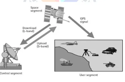
Today, Global Positioning System (GPS) is widely used in almost every aspect of our daily life. Commonly, users utilize the technology to track the position of a vehicle or an object of interest. They also use it to safely navigate to the destination of their choice. As a result, there is countless number of GPS based tracking application that has been developed. The GPS is made up of three parts: satellites orbiting the Earth; control and monitoring stations on the Earth; and the GPS receivers owned by users. GPS satellites broadcast signals from space that are picked up and identified by GPS receivers. Each GPS receiver then provides three-dimensional location (latitude, longitude, and altitude) plus the time. Furthermore GPS consist of three segments as shown in Fig. 2, the space segment, the control segment and the user segment.
[1] The space segment consists of a nominal constellation of 24 operating satellites that transmit one-way signals that give the current GPS satellite position and time.
[2] The control segment consists of worldwide monitor and control stations that maintain the satellites in their proper orbits through occasional command maneuvers, and adjust the satellite clocks. It tracks the GPS satellites, uploads updated navigational data, and maintains health and status of the satellite constellation.
[3] The user segment consists of the GPS receiver equipment, which receives the signals from the GPS satellites and uses the transmitted information to calculate the user’s three-dimensional position and time.
IV. GEOGRAPHIC INFORMATION SYSTEMS (GIS)
GPS technology is used extensively in geographic information systems. These systems combine cellular data networks for communication, GPS for vehicle location, and geographic information system tools for apping display. Use of GPS in GIS will permit state and local governments to more efficiently coordinate roadway maintenance and construction in rural areas, provide ancient ways of maintaining roadway databases, and maintain accident inventories.
V. APPLICATIONS OF GPS
Due to the high accuracy, versatility, ease and economy of operation, and all-weather operation offered by GPS, it has found numerous applications in many fields, ranging from the mm-level high precision geodesy to the several-metre level navigational positioning. Some of these applications are:
Establishment of high precision zero order Geodetic National Survey Control Network of GPS stations.
Strengthening, densification and readjustment of existing Primary Control Networks using GPS stations.
Connecting remote islands to mainland Geodetic Control Networks. Determination of a precise geoids using GPS data.
Earth rotation and Polar Motion Studies from GPS data. Estimating gravity anomalies using GPS.
Marine Geodesy: positioning of oceanic stations buoys etc.
Earthquake monitoring: Crustal movements of the order of few cm/year can be monitored using GPS method, thus making GPS most suitable for monitoring continental drifts, geotectonic / seismotectonic movement, etc.
Vertical Control Network : High accuracy of few mm in heights achievable with GPS at much less cost and time compared to leveling to make GPS method most suitable for establishing lower accuracy vertical control networks.
Geophysical positioning, mineral exploration and mining. Survey control for topographical and cadastral surveys.
Ground control for photogrammetric control surveys and mapping. Offshore positioning: Shipping, offshore platforms, fishing boats etc.
Instantaneous time transfer over trans-continental distances with accuracies of few nano seconds.
Space craft tracking: Vector separation between GPS satellites and any other satellites can be monitored by GPS, e.g., pinpointing the location of LANDSAT etc.
General aircraft navigation, approach to runways, navigation/positioning in remote areas like deserts, dense jungles, shaded areas of microwave, precise sea navigation, approach to harbours etc. It is expected that in 1990s most civilian aircrafts, ships, boats will be fitted with GPS equipments and even hikers, boat and car owners, truck drivers will be using it extensively.,
Military ; Improved weapon delivery accuracies i.e. for missiles etc., for ranging in artillery, navigation for Army, Navy, Air force - thus affecting ultimate saving of up to 1 billion dollars annually on navigation in U.S.A.
VI. CONCLUSIONS
Thus, we conclude, that GPS technology is very important to everyone because it helps users in different daily life activities such as map navigation, product tracking and more. GPS is very important tool for navigation and tracking purpose. GPS plays an important role in position tracking and map navigation. Today, there are many GPS based application being developed, such as Waze, Google Maps, HERE maps and so on. Its popularity has increased drastically and covered almost all the domains. This paper explains about GPS and its components. It also discusses about Accuracy and Precision which is the two major factors affecting the performance of GPS. Lastly the applications of GPS are explained in a detailed manner. GPS is an essential element of the global information like the internet and mobile in modern times, infrastructure and advanced revolutionary technology that changing and operate in the various field of development. The free, open, and dependable nature of GPS has led to the development of hundreds of applications affecting every aspect of modern life. GPS technology is now in everything from cell phones and wrist watches to bull dozers, shipping containers, and ATM's. GPS plays a vital role in tracking out vehicles. It also helps in providing easier routes. In case of a Disaster, the most appropriate emergency response personnel such as rescue, fire, police, ambulance personnel to allow much quicker and more accurate response efforts and further reduce disaster impacts.
ACKNOWLEDGMENTS
One of the authors DR. HRIDAYA NAND SAH takes this opportunity to thank Prof. (Dr.) B.K. Azad (M.Sc., Ph.D.), Retired Principal, R.D.S. College, Muzafferpur Former HOD, Department of Mathematics R.D.S. College, Muzafferpur, Bihar (INDIA), for numerous discussions, valuable suggestion and help in preparing the present research paper for publication. I also feel indebted to some scientific spiritualists who provided us the enthusiasm to undertake scientific studies with a wholesome attitude.
REFERENCES:
[1] Branford, W Parkinson, & Spliker, Global Positioning System : Theory and Applications, Volume 1, Amer List of Aeronautics, 1996.
[2] Gobi S. Introduction to GPS: Principles and Applications, Tata McGraw Hill Publishing Company Limited, New Delhi.
[3] A E Rabbery, Introduction to GPS: The Global Positioning System , Artech Publishers, 2006. [4] P. Singal & R. S. Chiller, A review on GPS & its applications in computer science, International Journal of Computer Science and Mobile Computing, Vol 3, Issue 5, 2014.
[5] Thomas A. Herring, Geodetic Applications of GPS,Vol. 87, No. 1, January 1999.
[6] H. Yavasoglu’, E. Tari’, M. Sahin’, H. Karaman’,T. Erden’, S. Bilgi], S. Erdogan’, Applications of Global Positioning System (GPS) in Geodynamics: With Three Examples from Turkey, Afyon Kocatepe University Department of Geodesy and Photogrammetry, 2005
[7] Philip Moore and Peter Crossley, GPS applications in power systems, Power Engineering Journal February 1999, 33.
[8] Henry, Saravanan & Kulathuran, Applications of GPS in Fisheries and Marine Studies, International Journal of Advance Research in Computer Science, Vol 2, No 6, 2011.
[9] Kundu & Chandana, Remote Sensing and GPS , Tapati Publisher , 9/4 Tamar Lane, Kolkatta, 2014.
[10] P. Verma & J H Bhatia, Design & Development of GPS and GSM based Tracking system with Google based monitoring, in International journal in Computer Science Engineering and Applications, vol 3, no 3, 2013.
[11] Ackroyd N. and Lorimer N, 1990, Global Navigation: A GPS User’s Guide (London: Lloyds of London Press).
[12] Ferguson M., 1997, GPS Land Navigation, (Boise, ID: Glass ford Publishing). [13] Leick A., 1995, GPS Satellite Surveying, (New York: Wiley).
Chelsea, MI. 268p.
[16] Thompson, Lt. Col. and Capt. G. Bomford (1930), The Lambert Grid for India, Survey of India, Special Publication No.1.
[17] Wells, D.E. (1988), edt., Guide to GPS Positioning, Canadian GPS Association, New Brunswick, Canada.
[18] Hoffman-Wellenhof B., et.al. (1997), GPS Theory and Practice, 4th Rev. Edition, Springer Wien, New York.
[19] Seeber G. 2003., Satellite Geodesy (2nd Edition), Walter de Gruyter Inc.