Mental map and spatial thinking
Sonia Maria Vanzella Castellar
aand Paula Cristiane Strina Juliasz
aa School of Education; University of São Paulo (USP); [email protected] b School of Education; University of São Paulo (USP); [email protected]
Abstract: The spatial thinking is a central concept in our researches at the Faculty of Education of University of São Paulo (FE-USP). The cartography is fundamental to this kind of thinking, because it contributes to the development of the representation of space. The spatial representations are the drawings - mental maps - maps, chart, aerial photos, satellite images, graphics and diagrams. To think spatially - including the contents and concepts geographical and their representations - also corresponds to reason, defined by the skills the individual develops to understand the structure, function of a space, and describe your organization and relation to other spaces. The aim of this paper is to analyze the role of mental maps in the development of concepts of city and landscape - structuring concepts for school geography. The purpose is to analyze how students in Geography and Pedagogy - future teachers – and young children in Early Childhood Education think, feel, and appropriate these concepts. The analys is indicates the importance of developing mental map in activities with pedagogy and geography graduate student to know that students at school can be producers of maps. Cartography is a language and allows the student to develop the spatial and temporal relationships and notions such as orientation, distance and location, learning the concepts of geographical science. Mental maps present the basic features of the location such as the conditions - the features verified in one place - and the connections that is to understand how this place connects to other places.
Keywords: Spatial thinking, School cartography, Geography
1.
Introduction
Spatial thinking has been a central concept in our research, with funding from São Paulo Research Foundation (FAPESP), the National Council for Scientific and Technological Development (CNPQ) and the Coordination of Improvement of Higher Level Personnel (CAPES) based on concepts of school geography, spatial representations and thinking skills. These concepts are based on the analysis of students and teachers conceptions of landscape, territory, place and city.
In this article we will present research data that show us how spatial thinking consists of the mobilization of geo- graphic reasoning over space, e.g., The relationships between units of measure, different ways of calculating distance (miles, travel time, travel costs), coordinate systems, the nature of spaces (two-dimensionality and three- dimensionality).
By accessing the spatial or geographic thinking literature, we note its importance for Geography and how much it can be developed in the school through principles and geographical concepts. Furthermore, it also involves the spatial representation, e.g., cartographic concepts such as vision (vertical, oblique and frontal), notions of measure and proportion, the projection effects and principles of graphic design. For this, the teaching of cartography becomes fundamental for this type of thought, since it contributes to the development of the representation
understanding spatialized geographic phenomena. Spatial representations can be the drawings (sketches or mental maps), maps, charts, aerial photographs, satellite images, graphs, anamorphosis and diagrams. Thinking spatially, understanding the contents, and geographical concepts and their representations, also involves the reasoning. Reasoning is defined as the skills we develop to understand the structure and function of a space, and to describe its organization and relation to other spaces. Thus, to analyze the order, relationship and pattern of spatial objects. The objective of this article is to discuss the role of mental maps in the development of city and
landscape concepts, structuring concepts for school geography. We seek to analyze how the future Geography teachers, in an un- dergraduate course, think, feel and take ownership of city and landscape
concepts, so that it can be worked in the In- fant Education.
the student may be stimulated to think ge- ographically.
By taking cartography as a language that allows the development of spatial and temporal relations and notions of orientation (distance and location), we build the concepts of the geographic science (landscape, territory and space). Mental maps exhibit the fundamental characteristics of location, such as conditions and connections. Conditions are the characteristics that define a place. Connections allow understanding how this place is connected t o others. The methodology used for this research is qualitative interpretive. The subjects were the students of the pedagogy course and children from five to six years old, in Early Childhood Education, in the city of São Paulo, Brazil.
2.
Reading the mental map to identify the living
spaces of pedagogy students and children in early
childhood education
In our research, we have analyzed the efficacy of cognitive development in children and adults in mapping activities and spatial perceptions. The maps have been used daily to represent different themes of everyday life, e.g., air masses or family income, and they are important tools for geographers, architects and urban planners. Understanding the cartography as a methodological approach at school is fundamental because it is a learning strategy to stimulating the student's cognitive development, the function of cartographic representation, concepts and abilities of spatial thinking. The map as a methodological approach is an essential strategy for students to understand any representations of the world. It is important to understand the role of school cartography since the beginning of schooling of children and to create ways to improve the quality of content in the initial training of undergraduate students, especially the Pedagogy courses, professionals who will teach for young children.
Classroom investigations reveal the need to understand the topological, projective and Euclidean spatial relation- ships or measures, area and proportion, and visual variables to understand the intentions or subjectivities of the maps.
In this sense, the research allowed us to analyze the effectiveness of mental maps in the construction of spatial thinking skills. The research activities were elaborated and developed from the idea of the map as an approximate representation of the real. In the activities with the children, the procedures used were children's stories and in the activities with the undergraduate students, it was through the preparation of mental maps from the living places as reference.
Mental maps also considered cognitive maps are part of the beginning of cartographic literacy because this maps can be help the learning. The representations made by the students about the places visited in a fieldwork and the
places lived daily allow to recognize how they perceive the city and how they locate the places, the notion of dis- tance, proximity and spatial orientation. Therefore, these representations imply the way in which they take owne r- ship of the cartographic and geographical concepts and show the difficulty in elaborating a mental map applying basic concepts of cartography, such as legend, scale/proportion, vertical and oblique vision, references and orienta- tion. The same process can occur with children, from early childhood education, when they make the school sur- rounding paths or children's stories. The representation by the drawing involves the relationship between concepts that covers the space as distance and position and spatial thinking skills, which are deployed from a spatial problematic, e.g., the child thinks about the arrangement of the elements in the graphic space, in an order.
The drawing of a space traveled allows the student to reflect and systematize a thought through the concretization of the lived space, creating symbols for each space object. This type of drawing allows the teacher to know how children conceive and represent the space.
The individual design on a space mobilizes different cartographic concepts, although without the characteristic rigor of this language. Reducing an object or place to insert it into the graphic space, creating elements such as the baseline with grams and the skyline with clouds and sun are ways created by children to establish relationships be- tween objects drawn in an order and establish graphic elements that symbolize real objects.
The children's map introduces notions of space representation, as well as the idea of map as a social production and when children draw, they think about space and the teacher can introduce certain geographical knowledge. Cognitive or mental map is a metaphor, because it enables the child or any student to create their maps and symbols. The word “cognitive” is used because the mental map stimulates the thinking; it helps students to move from a higher level of knowledge to a higher level of knowledge.
reasoning in relation to the functions of selecting, grouping, classifying among others. Recognizing the place of living, finding objects, knowing how to move around and identifying directions are basic actions and contents that should be developed with students since Early Child- hood Education.
The mental map can be the beginning of a methodological course in the classroom, stimulating the study of the living place and helping in the reading of a conventional cartographic representation. It includes abstract categories of elements, parts of the landscape and environment, such as paths, references, elements that have a hierarchical relationship of class inclusion. These categories related to the knowledge of the place, i.e., the recognition of the place of the objects and phenomena represented.
The representational symbolic thought present in the mental map stimulates spatial thinking, through learning situations using symbols and signs. The school cartography has this role, when working with location, arrangements, networks, region, besides the visual variables, geometric forms, colors and other signs, scale / distance, creating conditions to identify the geographic phenomena represented in a territory. The child can understand the place where he or she lives, the distance between places, the direction he should take, from the map. The distance between places is part of the spatial relationship process that the map represents and the process of comparing distances on the map and in reality. This analysis emphasizes the idea of how to create conditions for the student to develop spatial thinking. To analyze the drawings, we take as base the studies of Gersmehl (2008). This author has proved that spatial reasoning can count on eight distinct processes, such as comparison, aura, regions, transition, hierarchy, analogy, pat- terns and associations. These processes occur in different parts of the brain and involve different memory networks, not consisting of a single, isolated type of intelligence.
According to Gersmehl (2008), Geography has as its principle the location of things, of places, articulating the conditions and connections between places. Gersmehl helps us think about how we can encourage children to under- stand Geography. This idea makes it possible to think about where we are in the world, to know the places and how people live and to analyze the relationships between places. Just as we can relate to where we are in time and space on Earth, this is critical for children to understand their place on Earth and those of other people, as well as the organization of these places.
In this article, we will mainly discuss the skill called spatial transition. The spatial transition has relation with the notions of time and space together, through the sequence of places or things, and has the word "between" as the key in the way of thinking. This is also related to memorizing a path and the places that make it up, as it consists of moving from one place to another. The main question is "what is there between the elements (places, for example) in space?"
The cartography is a language that mediates between living and representation, stimulating spatial thinking and contributing to the reading of different forms of representations. The cartographic language as mediation in the teaching and learning process is associated with form, i.e., as a methodological procedure that stimulates the students’ geographic reasoning.
In this sense, pedagogy students drew up sketches to analyze the use of cartography as a strategy to overcome common sense by study and use of tools and concept such as scale, projections, time zone and geographic coordinates (Figures 1 and 2). These concepts are fundamental for space education of students for the development of other geographical concepts.
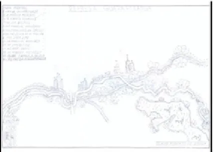
Figure 1. Teacher’s mental map (Source: authors’ collection)
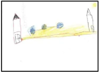
Figure 2. Teacher’s mental map (Source: authors’ collection) With this perspective, we elaborate a sequence of activities with children from 5 to 6 years old, with the main objective of understanding that a path - the whole - is composed of places - the parts. In a short walk inside the school, we developed the idea that classrooms are part of larger place, the school, and that there is a transition between places, that is, a sequence of rooms. We consider as possible the abilities practiced by the children the comparison, hierarchy and transition.
established through the signs created by the children; B) without relation between places: the children present the places that make up the route, but do not establish an explicit relation between them; C) line and points: children call lines and points as path or map. Thus, we aimed to understand the patterns that occur in children’s drawing, as can be seen in Figures 3, 4 and 5.
Figure 3. Category A. (Source: authors’ collection)
Figure 4. Category B. (Source: authors’collection)
Figure 5. Category C. (Source: authors’ collection)
In addition, we create activitie so that teachers could understand school cartography in another way, not as technical concepts for reading maps, but as language and activities. Thus, being able to relate, establish spatial hier- archies and create criteria to regionalize, for example. During the research, we asked them to make mental maps of the route taken in the fieldwork, representing the places where they passed. An interesting aspect was the difficulty of carrying out the activity, remembering the paths and identifying the main points. This difficulty reveals that students need to be aware of the cartographic literacy process; Aware of the objectives of the teaching strategies; Aware of the importance of having practical activities in the classroom that allow children to think in terms of space.
Following the foundations of Philip Gersmehl in partnership with Carol Gersmehl, we analyzed with the students of pedagogy the function of the cognitive map. We took as reference a) the brain presents structures for spatial reasoning and are fully functional at a very early age; b) the intervention of an adult can improve both the use and the representation of maps; c) practices in early grades are important, perhaps essential, for the learning of geography in subsequent years. (Gersmehl and Gersmehl 2007). Therefore, it would be an important practice with the students, even if around school.
The pedagogical activities discussed with the students, future teachers, brought the need to consider cartography as language. The representation of a path (cognitive or mental map) or the reading of a thematic map allows the student to identify and perceive the geographical elements that exist in his neighborhood, for example. Activities in which children relate the concepts of area, size, distance, and the description of neighborhood reference points can contribute to the conceptualization of scale and the notion of proportion. In this way, it is possible to stimulate spatial thinking, also involving different forms of spatial reasoning, such as spatial comparison, spatial influence, spatial groups (regions), spatial transition, spatial hierarchy, spatial analogy, spatial patterns and associations, as discussed by Gersmehl (2011).
Another aspect discussed with the undergraduate students, after the development of fieldwork mental maps and the sketch, was the need to retake concepts of city, urban, place, and the principles of geography. To Moreira (2007:
117) the categories and "categories of categories" (considered as geographical principles) are structuring to think the territory and the world. In this context, we add the importance of these "categories of categories" insofar as they also structure school cartography. That is, for children to be scientifically literate in geography, they need to think in this perspective, articulating geographic contents with spatial thinking.
These principles are usually used in everyday life because of the location and distance of places and between them. If the logical principles are the principles of location, distribution, extension, distance, position and scale. The ancients understood the primary and central importance of these principles in the formation of personality and discourse of geographical representation. Organizing and structuring geographically meant simultaneously, for them, to locate, distribute, connect, distance, delimit and scape relations in the landscape and transport it to the map. Only then could one analyze the relation human -environment/human-space in its geographic dimension (Moreira 2007, 116)
student will understand and make interpretations of reality.
Categ
ories categories of the categories
Space Location, distribution, distance, extension, position
and scale Territ
ory Region, place, network Lands
cape Arrangement, configuration
Table 1. Geographical categories. (Source: Moreira 2007, 117) The idea makes more sense when Moreira (2007) states that everything in geography begins with the logical principles. First, we must locate the landscape phenomenon. The set of locations gives the picture of the distribution. Then, we have the distance between the locations within the distribution. Moreover, with the network and connection, we have the extension, which is already the principle of unity of space. Following, comes the delimitation of the extension cuts, coming to light the territory. This is considered a method of analysis for geography and the fieldwork contributes to this perception. This means that the analysis is important for understanding the territory and landscape concepts. At school, geographical education can start from the structured relation society-nature in the combined form of landscape, territory and space, through principles, contributing to the recognition of cultural action in different places and the interactions of different societies with nature, along history. It allows students to understand the position of places and their connections with others, over time, taking space as a dynamic product that reflects the relation- ship between science, society, technology and the environment.
The investigation procedures allowed us to answer the question: How spatial reasoning can be defined? This question mobilizes us to think about spatial abilities and the need to consolidate the discussion of geographical principles in school contents. Then new questions are suggested: What skills or knowledge is relevant to the student's understanding of space and its organization? How to perceive the location of objects and phenomena spatially?
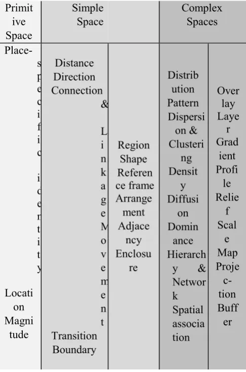
These questions put us before the way we organize the classes and their contents. Students noted the nee d to work on spatial concepts of distance, direction and region. These should not be considered as simplistic content, in a common sense. Instead, they realized the importance of discussing them with their students, promoting spatial thinking. These spatial concepts can also be perceived and read on maps, or in any other graphical representation. The process of reasoning is developed through the conceptualization and resolution of problems. For the researchers Jo, Bednarz and Metoyer (2010) spatial thinking can be facilitated by careful planning, selection and use of questions. For this reason,
they organized a taxonomy composed of three categories, as can be seen in the following table.
Primit
ive
Space
Simple
Space
Complex
Spaces
Place-s
p
e
c
i
f
i
c
i
d
e
n
t
i
t
y
Locati
on
Magni
tude
Distance
Direction
Connection
&
L
i
n
k
a
g
e
M
o
v
e
m
e
n
t
Transition
Boundary
Region
Shape
Referen
ce frame
Arrange
ment
Adjace
ncy
Enclosu
re
Distrib
ution
Pattern
Dispersi
on &
Clusteri
ng
Densit
y
Diffusi
on
Domin
ance
Hierarch
y &
Networ
k
Spatial
associa
tion
Over
lay
Laye
r
Grad
ient
Profi
le
Relie
f
Scal
e
Map
Proje
c-
tion
Buff
er
Table 2. Hierarchy of spatial concepts. (Source: Bednarz and Jo 2009, 6)
School cartography, in the study of the city, stimulates the students to recognize different places, allowing to value or identify its image. In this way, Lynch states that maps allow us to recognize the readability of the image of a city. That is, enables the recognition of an urban form and its surroundings, organized in coherent units. In addition, follows:
Closely related to readability is the imageability or ability of an urban element to elicit a vigorous image in any observer. An effective image would then be, in terms of the author, one with a high legibility and a powerful imaginability. (Lynch 2012, 66)
write and think about their spaces. That is, mental maps allow materializing the space according to a system of representation, the drawing.
3.
Conclusions
This article presents a review of the research carried out with students of Pedagogy and children of Early Child- hood Education. We note the importance of didactic strategies involving spatial thinking skills. Through the data, we analyze the resumption of the geographical principles articulated with the concepts of space, territory and landscape, reaffirming the method of analysis to interpret spatial phenomena. The research results showed that school geography is able to overcome a traditional conception of cartography teaching, recovering logical principles, in order to make contents more critical and close to reality.
The answers to the questions show that spatial skills are critical to geo-graphic reasoning and establish the meth-od to analyze the phenomena of reality. The process of understanding mobility in space corresponds to the transition ability or spatial sequence of reasoning. Therefore, these spatial relations support the mobilization of spatial thinking skills and allow the development of fundamental concepts for Geography, such as location. Location is a fundamental geographical principle for the development of other concepts. It allows relating elements, obtaining a distribution and distance frame. Thereby, the understanding of a certain object position occurs beyond that of the Cartesian intersection of two points in a plane and, thus perceive the spatiotemporal relation.
Spatial thinking is a cognitive activity that allows children to reflect, criticize, compare and understand their place in the world. This research stands out for the proposition of theoretical-methodological references for the spatial knowledge of children from five to six years, from sequences of activities mobilizing spatial thinking, contributing to a cartography pertinent to childhood, based on the interaction of Children and adults, and in children's graphic productions.
4.
Acknowledgements
We are grateful to the São Paulo Research Foundation (FAPESP), the National Council for Scientific and Technological Development (CNPQ) and the Coordination of Improvement of Higher Level Personnel (CAPES), by funding this research.
5.
References
Gersmehl, P. J. (2008) Teaching Geography. New York: Guilford Press. 2008.
Gersmehl, P. J.; Gersmehl, C. A. (2007) Spatial thinking by young children: Neurologic evidence for early development and ‘educabil- ity.’ Journal of Geography, 106 (5), p. 181–19.
Gersmehl, P. J.; Gersmehl, C. A. (2011) Spatial Thinking: where pedagogy meets neuroscience.
Problems of Education in the Twenty First Century, 27, 47 – 66.
Jo, I.; Bednarz; S.; Metoyer, S. (2010): Selecting and Designing Questions to Facilitate Spatial Thinking, The Geography Teacher, 7 (2), 49-55
Jo, I; Bednarz, S. W. (2009) Evaluating geography textbook questions from a spatial perspective: using concepts of space, tools of representation, and cognitive processes to evaluate spatiality. Journal of Geography 108 (1), 4-13.
Lynch, K. La Imagen de la Ciudad. Barcelona: GG, 2012
Mooney, P., Corcoran, P. and Winstanley, A.C. (2010). Towards Quality Metrics for OpenStreetMap, ACM SIGSPATIAL GIS'10, November 2–5, 2010, San Jose, California (accepted).
Werder, S., Kieler, B. and Sester, M. (2010). Semi-Automatic Semantic Interpretation of Buildings and Settlement Areas in User-Generated Spatial Data. ACM SIGSPATIAL GIS'10, November 2–5, 2010, San Jose, California (accepted).