i
CLASSIFYING SINGLE-THREAD
RIVERS: A EUROPEAN
PERSPECTIVE
QUEEN MARY UNIVERSITY OF LONDON
SCHOOL OF GEOGRAPHY
PRIMA WORO SEKARSARI
SUBMITTED IN PARTIAL FULFILLMENT OF THE REQUIREMENTS OF THE DEGREE OF DOCTOR OF PHILOSOPHY
1
STATEMENT OF ORIGINALITY
I confirm that the work here presented is my own. Information derived from other sources is indicated in the thesis.
Signed:
2 PhD in River Science
Research for this thesis was conducted within the framework of SMART (Science for MAnagement of Rivers and their Tidal systems), which is an Erasmus Mundus Joint Doctoral Programme (EMJD).
EMJDs aim to foster cooperation between higher education institutions and academic staff in Europe and third countries with a view to creating centres of excellence and providing a highly skilled 21st century workforce enabled to lead social, cultural and economic developments. All EMJDs involve mandatory mobility between the universities in the consortia and lead to the award of recognised joint, double or multiple degrees.
The SMART programme represents a collaboration among The University of Trento, Queen Mary University of London, and Freie University Berlin. Each doctoral student within the SMART programme has conformed to the following during their 3 years of study:
(i) Supervision by a minimum of two supervisors in two institutions (their primary and secondary institutions).
(ii) Study for a minimum period of 6 months at their secondary institution
(iii) Successful completion of a minimum of 30 ECTS of taught courses
(iv) Collaboration with an associate partner to develop a particular component / application of their research that is of mutual interest.
3
ABSTRACT
This thesis develops and tests a classification of ‘near-natural’ European
single-thread rivers, which are free to adjust to fluvial processes. The research involves subdividing rivers along a continuum of geomorphological characteristics to assign river reaches to geomorphologically-meaningful classes according to their channel dimensions and forms, and floodplain characteristics.
The classification was developed and tested through three research components.
First, a preliminary classification was developed using information entirely derived from a new information system containing remotely-sensed imagery and digital terrain data: Google Earth. This research stage required the development of rules for identifying, extracting and standardising information from this source for a large sample of river reaches. 221 single-thread river reaches distributed across 75 European rivers were investigated. Analysis of the derived information resulted in the development of a classification comprising six classes of European single thread river.
Second, the robustness of the classification was explored including assessments of (i) the degree to which the classes were interpretable in relation to the geomorphic features they displayed; (ii) the degree to which sub-divisions of the six classes could be identified and justified; (iii) the accuracy of some specific types of information extracted from Google Earth; and (iv) the degree to which the six classes corresponded to expected gradients in two controlling variables: stream power and bed sediment calibre.
Thirdly, bar theory was applied to a sample of rivers representative of the six classes. Since bars are an important contributor to river channel form and dynamics, the correspondence of the bars in the six river classes to their expected distribution as indicated by bar theory, provided further confirmation of the robustness of the classification.
5
CONTENTS
Statement of Originality ... 1
Abstract ... 3
Contents ... 5
Table of Figures ... 9
Table of Tables ... 15
Attribution Page ... 18
Acknowledgements ... 19
1 Chapter 1 Introduction ... 21
1.1 Rationale ... 21
1.2 River Classification ... 24
1.3 The Research ... 24
2 Chapter 2 Literature Review ... 26
2.1 Introduction ... 26
2.2 Channel patterns ... 26
2.2.1 Channel pattern classification ... 26
2.2.2 A channel style continuum ... 31
2.3 Single-thread rivers: planform and controlling factors ... 34
2.3.1 Characteristics of sinuous to fully meandering rivers ... 35
2.3.2 Key factors controlling meandering ... 46
2.4 Single-thread rivers: bars and other geomorphological features ... 49
2.5 Research questions ... 62
3 Chapter 3 A preliminary classification of single-thread European rivers using European data extracted from GoogleTM Earth ... 64
6
3.2 Research Context ... 64
3.2.1 Geomorphological Classification of Rivers ... 64
3.2.2 Design and Measurement Quality ... 67
3.2.3 Geospatial Data ... 68
3.3 Methods ... 70
3.3.1 Site selection ... 71
3.3.2 Defining relevant geomorphological, vegetation, and channel geometry features to support consistent data extraction ... 75
3.3.3 Data extraction and preparation ... 89
3.3.4 Statistical analysis ... 97
3.4 Results ... 100
3.4.1 Principal Components Analysis (PCA) ... 100
3.4.2 Agglomerative Hierarchical Cluster Analysis (AHC) ... 105
3.5 Discussion ... 116
3.5.1 Interpreting the River Classification ... 116
3.5.2 Google Earth as a Data Source for River Science... 117
4 Chapter 4 Exploring the robustness of the classification ... 121
4.1 Introduction ... 121
4.2 Properties of the six classes of river ... 122
4.2.1 Geographical distributions of reaches within the six classes ... 122
4.2.2 Frequency distributions of channel and floodplain properties within the six river classes ... 124
4.3 Is subdivision of the 6 classes informative ... 132
4.4 Assessment of the accuracy of elevation data extracted from Google Earth . 138 4.5 Influence of the image selected on river reach classification ... 143
4.6 Impact of including additional variables from other data sources ... 149
4.6.1 River flow data ... 149
4.6.2 Sediment data ... 159
7
4.8 Application of the Classification to Restored River reaches in England ... 170
5 Chapter 5 Embedding theoretical morphodynamics ‘bar theory’ into the classification of single-thread rivers ... 176
5.1 Introduction ... 176
5.2 Methods ... 182
5.2.1 Problem formulation ... 182
5.2.2 Sediment load predictors ... 184
5.2.3 Linear solution ... 185
5.2.4 Input data ... 188
5.2.5 Assumptions ... 195
5.3 Implications of morphodynamic “Bar” Theory for single-thread rivers ... 196
5.3.1 Behaviour of the values of theoretical parameters across the five classes of river reach... 196
5.3.2 Geomorphic and vegetation features observed within reaches associated with the three theoretical regimes ... 200
5.4 Sensitivity of outcomes to input variables ... 203
5.4.1 Choice of bar forming discharge value ... 203
5.4.2 Sediment predictors ... 206
5.5 Discussion and Conclusions ... 212
6 Chapter 6 Discussion ... 214
6.1 Introduction ... 214
6.2 Research results ... 214
6.2.1 Can a geomorphologically-interpretable classification of single-thread sinuous to meandering European rivers be compiled using data extracted from aerial imagery (Chapter 3)? ... 215
6.2.2 To what extent does the classification remain robust, when tested using data sets from other information sources (Chapter 4)? ... 219
8
6.3 Discussion of the Research Outcomes ... 222
6.3.1 Scientific Advances in Relation to Previous River Classification Research 222 6.3.2 Links between the Google Earth classification and bar theory. ... 232
6.3.3 The usefulness of the Google Earth classification and its potential application in Management ... 233
6.4 Limitations of the research ... 236
6.4.1 Google Earth as a data source ... 236
6.4.2 Thorough testing of the classification ... 237
6.5 Recommendations for future research ... 240
6.5.1 Increasing the size and quality of the data set ... 240
6.5.2 Increasing the complexity of the classification ... 240
6.5.3 Developing the classification into an applicable tool for river managers 240 6.5.4 Applying the classification in practice ... 241
6.5.5 Linking the classification to theory ... 241
6.6 Conclusion ... 242
7 References ... 243
9
TABLE OF FIGURES
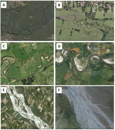
Figure 1.1 Examples of European rivers of different planform. A. Narew, Poland; B. Frome, England; C. Towy, Wales; D. Loire, France; E. Tagliamento, Italy; F. Val Roseg, Switzerland. ... 22 Figure 2.1 Classification of channel patterns (from Church, 2006, from Schumm, 1985 and Church, 1992) ... 27 Figure 2.2 Classification of degree of meandering (from Kellerhals et al., 1976) ... 29 Figure 2.3 Alluvial river classification of single thread and related anabranching systems (from Nanson and Knighton, 1966)... 30 Figure 2.4 Values of channel slope and bankful discharge from various natural channels and a proposed threshold between braided and meandering channel planforms (from Leopold and Wolman, 1957)... 32 Figure 2.5 Discrimination of straight, meandering and braided channels and also the degree of braiding based on the ratios of slope:Froude number and depth:width (from Parker, 1976) ... 33 Figure 2.6 Channel patterns in relation to gradients in grain size and unit stream power (from Kleinhans and Van den Berg, 2011) ... 34 Figure 2.7 Planimetric and cross sectional form of a meandering river (from Morisawa, 1985) ... 35 Figure 2.8 Meander geometry sketch (from Leopold et al., 1964) ... 37 Figure 2.9 Single-thread alluvial river patterns with classes categorized according to the distribution and degree of spatial variation in channel width (modified from Brice, 1975 by Lagasse, et al., 2004) ... 38 Figure 2.10 Wave number distribution of bends for wider-at-bends (class C) and equi-width meandering channels (class B1) (from Lagasse et al., 2004) ... 39
10
Figure 2.12 Meander loop classification with flow direction from left to right (from
Brice, 1974) ... 41
Figure 2.13 Flow in a meander bend (Leopold and Wolman, 1960; Crosato, 2008) ... 42
Figure 2.14 Meander neck cut off process (image credit: Bruce Railsback) ... 45
Figure 2.15 Planform stability diagram plotting (a) data from rivers with sparse bank vegetation and (b) data from rivers with dense bank vegetation. (open symbols are meandering rivers and solid symbols are braided rivers; rivers in areas I and III are meandering and braided, respectively, regardless of bank vegetation, whereas rivers in area II will only meander if they have dense, deep-rooted bank vegetation) (from Millar, 2000). ... 49
Figure 3.1 A hierarchy of spatial scales, illustrating how the character of a river reach, including the geomorphic units that it contains, is influenced by processes cascading through larger spatial units now and in the past, and how the process cascade influences the future character of the reach (from Gurnell et al., 2014). ... 65
Figure 3.2 An example of three replicate reaches of River Dee, UK, and indicated by yellow, red and light blue lines from upstream to downstream. ... 72
Figure 3.3 A. Decision tree used to identify sites and reaches for analysis B. Decision tree used to refine the recorded feature set and to record individual features ... 74
Figure 3.4 An example of lateral bar ... 90
Figure 3.5 A. Instream chute feature B. Floodplain chute feature ... 91
Figure 3.6 A. Bar and B. Bench ... 91
Figure 3.7 Vegetation development ... 92
Figure 3.8 Classes of Riparian Vegetation Complexity ... 93
Figure 3.9 Bank-top Riparian Tree Distribution ... 93
Figure 3.10 AHC Dendrogram based on the scores of 221 river reaches on 10 geomorphologically-informative PCs (the emboldened numbers labelling each cluster correspond to those in the text and the number of reaches (n) in each cluster is indicated in italics). ... 106
Figure 3.11 Scatter plot illustrating the scores of reaches within the eight clusters on PC1.1 and PC1.2. ... 109
Figure 3.12 Scatter plots of reach scores on PC1.1 against PC2.1 (top left), PC3.1 (top right), PC4.1 (bottom left) and PC4.2 (bottom right) coded by cluster membership ... 110
11
12
Figure 4.7 Boxplots illustrating differences in vegetation features across the six classes of reach: A. (Riparian) vegetation structure; B. Tree distribution along the bank tops; C. wood accumulations; D. (abundance of) emergent macrophytes. ... 131 Figure 4.8 Cluster dendrogram showing the original six classes / clusters with the number of reaches (n) contained in each (divided by thick red lines) and the first splits of each cluster (divided by the narrow red lines) with the number of reaches (n) contained in each split ... 133 Figure 4.9 Scatter plot comparing elevation estimates in m.a.s.l. extracted from Google Earth (vertical axes) and Lidar (horizontal axes) data for 25 reaches and 36 points .... 142 Figure 4.10 Box and whisker plots illustrating the elevation (m.a.s.l.) recorded within the six river classes for all reaches whose elevation was extracted from Google Earth. ... 142 Figure 4.11 Procedure used to calculate PC scores for the 12 new reaches within the original PCA spaces. ... 147 Figure 4.12 Changes in plotting position (from O to ×) of 12 reaches for which two images were analysed in relation to the first two PCs of the aggregate PCA and in comparison to the 221 rivers originally analysed. ... 148 Figure 4.13 Boxplots illustrating variation in discharges of different flood recurrence interval (daily flow data, annual maximum series) according to river class. (A) 2 year flood, (B) 5 year flood, (C) 10 year return period. ... 156 Figure 4.14 Boxplots illustrating variations in stream power for discharges of different flood recurrence interval (daily flow data, annual maximum series) according to river class. (A) 2 year flood, (B) 5 year flood, (C) 10 year return period. ... 157 Figure 4.15 Boxplots illustrating variations in unit stream power for discharges of different flood recurrence interval (daily flow data, annual maximum series) according to river class. (A) 2 year flood, (B) 5 year flood, (C) 10 year return period. ... 158 Figure 4.16 Boxplots illustrating bed sediment calibre estimates for British rivers in five of the six river classes. Upper graphs show D50; lower graphs D50B (includes bedrock
13
Figure 5.1 Theoretical regimes according the positioning of β, width-to-depth ratio to thethreshold of βc, aspect ratio critical and βr, aspect ratio resonant ... 180
Figure 5.2 A. Amplification of Ωr and Ωi versus wavenumber λ, for a fixed θ and ds and varying β and B. Marginal curve of bar amplification is produced at the crossing of Ωr and Ωi = 0 ... 187 Figure 5.3 Illustrative patterns of flow and bed deformation associated with the presence of bars (from Crosato, 2008) ... 196 Figure 5.4 Boxplots illustrating channel dimension and sediment properties of reaches across five classes of single-thread river ... 197 Figure 5.5 Scatterplots of β to θ with different symbols identifying: A. Aggregate type (black = gravel, red = sand); B. Sediment predictors (red = Engelund and Hansen, black =Parker); C. Super-resonant and sub-resonant behaviour (red = super-resonant, black = sub-resonant). ... 198 Figure 5.6 Boxplots illustrating variations in the values of the computed aspect ratios across the five classes of river reaches: A: aspect ratio, B: β critical, and C: β resonant.
... 199 Figure 5.7 A and B: Contrasts in A. the difference between the aspect ratio (β) and βcritical and B. the difference between the aspect ratio (β) and βresonant, across river
classes 1, 3, 4, 5 and 6. ... 200 Figure 5.8 Boxplots illustrating values of computed βcritical (left) and βresonant (right)
across the 5 investigated classes of river reach when computed using a daily discharge of: A. and D. (Q2) – the 2 year return period event; B. and E. (Q5) – the 5 year return
period event; C. and F. (Q10) – the 10 year return period event. ... 204
Figure 5.9 Boxplots illustrating variation in the values of computed βcritical (left) β-βresonant (right) across the 5 classes of river reaches when computed using discharge of
A, D 2-year interval B, E 5-year interval and C, F 10-year interval ... 205 Figure 5.10 Boxplots illustrating variation in the values of Shields range across the 5 classes of river reaches when computed using a daily discharge of: A. 2-year recurrence interval; B. 5-year recurrence interval; and C. 10-year recurrence interval ... 206 Figure 5.11 Sensitivity of the morphodynamic regimes to the choice of different bed load predictors: A. (β-βr)/βr B. (βr-βc)/βr C. (β-βc)/βr. The x-axis is Meyer-Peter
14
15
15
TABLE OF TABLES
16
16
Table 3.12 Integrated PCA of the scores on the PCs listed in Table 3.11: Eigenvalues, Variance Explained and Loadings (loadings greater than 0.7 are emboldened and those between 0.6 and 0.7 underlined) ... 105 Table 3.13 Results of Kruskal-Wallis tests applied to the PC scores on the 10 PCs listed in Table 3.11, grouped according to AHC clusters 1, 2, 3A, 3B, 4, 6 ... 108 Table 3.14 Upper and lower quartile values of channel bankfull width, slope and sinuosity of river reaches within each cluster and the degree to which each cluster shows significantly higher (pink shading) or lower (blue shading) than other clusters with respect to each of the 10 PCs. ... 115 Table 4.1 Groups of Raw and Aggregate Variables describing different properties of the river and its floodplain ... 125 Table 4.2 Statistically significant differences (Mann-Whitney U test, P<0.05) in reach scores between sub-classes or splits of the original 6 river classes on the 10 PCs that underpin the cluster analysis. Significant differences between the scores on each cluster with Pink shaded cells indicate those subclasses that show statistically significantly larger scores on a particular PC. ... 134 Table 4.3 Statistically significant differences (Kruskal-Wallis tests) in reach scores within the 6 classes of river on each of the 10 PCs that underpin the classification. The shaded cells indicate classes that show significantly higher (pink) or lower (blue) reach scores than the other classes on each individual PC. ... 135 Table 4.4 Values of elevation for the same points extracted from Google Earth (nearest m) and Lidar data (nearest cm) ... 140 Table 4.5 Details of the 12 reaches for which a second image was analysed from a different year and/or different season ... 143 Table 4.6 Summary information on standardised variables extracted from the images listed in Table 4.5 ... 145 Table 4.7 Gauging station names, codes, locations, record lengths and computed 2, 5, 10 year floods (annual series based on daily flows) for 55 rivers ... 150 Table 4.8 58 river reaches for which at least one RHS survey was available (RHS Ids are provided for all surveys that were analysed) ... 161 Table 4.9 Spot-check observations of channel substrate calibre, with associated sample sizes and estimates of D50 (in phi and mm units) for 58 reaches of British rivers
17
1
7
Table 4.10 Summary information on the four restored reaches selected for analysis (source: www.therrc.co.uk) ... 170 Table 4.11 Summary of information extracted from Google Earth images for the 4 restored and 12 control reaches. ... 171 Table 5.1 Sediment transport formula implemented on the mathematical analysis ... 185 Table 5.2 Summary properties of the 5 river classes investigated in this chapter. ... 189 Table 5.3 Reaches, observed / estimated values of D50, width, slope, sinuosity, Q2, Q5,
Q10 and derived estimates of the three parameters (, ds) required in the analyses
presented in this chapter. ... 191 Table 5.4 The number of reaches analysed from each of classes 1, 3, 4, 5 and 6... 194 Table 5.5 Abbreviations used to refer to the three morphodynamic regimes ... 200 Table 5.6 Results of Kruskal-Wallis (comparison of k samples) test applied to the geomorphic and vegetational units grouped according to the three regimes in Table 5.2 ... 202 Table 5.7 Output of βcr and βr (computed using fixed values of θ10 and ds10) in different
18
18
ATTRIBUTION PAGE
Firstly, I would like to greatly thank GoogleTM Earth which has generously provided the large archive of images across Europe from which I have extracted information. In collaboration with Google, there are companies who provided free and good resolution aerial imagery, they are:
Image Landsat, Infoterra Ltd and Bluesky, Getmapping plc, Digital Globe, IGN France, GeoBasis-DE/BKG, Cnes/Spot Image, Geoimage Austria, Eurosense/Geodis Slovakia, CNES/Austrium, MGGP Aero, Lantmaateriet/Metria, and Geodis Brno.
Secondly, I would like to thank the providers of daily discharge data. They are (1) The National River Flow Archive (NRFA) and (2) The Centre for Ecology and Hydrology (CEH) for British rivers, (3) ‘Ministère de l'Ecologie et du Développement Durable’ for French rivers, (4) ‘Centro de Estudios Hidrográficos’ for Spanish rivers.
19
19
ACKNOWLEDGEMENTS
Firstly, I would like to thank my main supervisor, Prof. Angela Gurnell, who always conveys a spirit of adventure and excitement in exploring science. She has inspired me in so many ways to continually learn many new things and to easily become absorbed by new encounters. I have also been extremely lucky, that she cared so much and paid very detailed attention to every aspect of my work. Without her guidance and persistent help this dissertation would not have been possible.
I would also like to thank Dr. Guido Zolezzi as my second supervisor, who always shows enthusiasm in theoretical science. The topic has been motivating, yet challenging for me. I was also lucky that he was able to facilitate me with a SMART EMJD scholarship for the second half of the PhD.
I would like to thank Dr. Alex Henshaw as my third supervisor, for providing me with efficient ‘geomorphological’ technical suggestions, fruitful discussions and practical sources of information for this thesis.
I would like to thank Dr. Bob Grabowski for providing me with a tremendous amount of information for British rivers such as LiDAR data, River Habitat Survey data, etc., and also for our motivating discussion about statistical methods in geomorphology.
I would like to thank Dr. Judy England, who provided me with a placement in the Environmental Agency so that I can gain understanding of some recent restoration projects in the United Kingdom.
A big thank you to Dr. Harry Dixon and Dr. Matt Fry from National River Flow Archives who provided me with flow data for Scottish rivers, and Dr. Virginia Garofano Gomez and Jean-Philippe Belliard, for links to access Spanish and French river flow records, respectively.
I also would like to thank Simone Zen, for letting me use his matlab ‘bar theory’ code
20
20
research. Thanks to Davide Vanzo, for providing me with much information and his didactical instruction, Luca Adami and Umesh Singh for our exciting scientific conversations.
I must express my gratitude to my family, Robert, Triworo and Wisnu, for their support and encouragement of my scientific passion. I was very grateful for their financial aid during the first half of this PhD.
Again, I would also like to personally thank Jean-Philippe Belliard, who constantly encourages me to pursue river science up to the highest degree through SMART EMJD and who supports me in many ways during the process.
I would like to thank the SMART programme in providing this particular joint doctoral program that has enabled me to enrol in different institutions and to grasp an inter-national and inter-disciplinary approach in the thesis, which is not common in a PhD program. Additionally, I would like to give a big thank you specifically to the SMART secretaries, Laura Martuscelli, Marina Rogato, Claudia Fraizingher, for their professional assistance in taking care of the many bureaucratic measures.
21
1
CHAPTER 1
INTRODUCTION
Rationale 1.1
In the absence of significant human modification, rivers vary enormously in their form (e.g. Figure 1.1). This variation does not simply reflect the large changes in climate, sediment availability and vegetation that occur from one biogeographical region to another, but also to variations in controlling factors within biogeographical regions and within individual catchments. Variations occur in both space and time and provide the challenging context in which human activities take place and river management strategies are developed. As far as is possible, river restoration and management need to work with these natural variations in river morphodynamics as well as the needs of human populations, in order to achieve cost-effective and sustainable river management solutions.
This thesis aims to contribute to improving river management outcomes, by developing and testing a typology of naturally-functioning single-thread rivers in Europe that is both simple and applicable but also scientifically sound. In order to constrain the research to something that is achievable within a three year PhD programme:
1. The focus is on Europe (i) for practical reasons of data availability, (ii) for scientific reasons, in that Europe covers a large area that incorporates a variety of biogeographical regions which might be expected to contain rivers of many different forms and dynamics; (iii) for management reasons, in that the area of Europe within the European Union is subject to the requirements of the Water Framework Directive, where the currently-applied ‘hydromorphological’ river typologies (A and B) are remarkably simple and
22
2. The focus is on single-thread rivers, because this group of river types is most common within Europe, particularly in areas where population density is relatively high and thus river management is a pressing concern.
3. The focus is on classification because this provides a simple framework for identifying the type of river that is of interest and then considering its likely geomorphic features and dynamics in the context of current and future management options.
Figure 1.1 Examples of European rivers of different planform. A. Narew, Poland; B. Frome, England; C. Towy, Wales; D. Loire, France; E. Tagliamento, Italy; F.
23
23
Table 1.1 System A and B River Typologies of the Water Framework Directive
SYSTEM A (Fixed typology)
Descriptors SYSTEM B
(Alternative characterisation)
Physical and chemical factors that determine the characteristics of the river or part of the river and hence
the biological population structure and composition
Ecoregion Ecoregions shown on map A in Annex
XI
Obligatory factors altitude
Altitude typology high: >800 m latitude
mid-altitude: 200 to 800 m longitude
lowland: <200 m geology
Size typology small: 10 to 100 km2 size
(based on catchment area) medium: >100 to 1 000 km2 Optional factors distance from river source
large: >1 000 to 10 000 km2 energy of flow (function of flow and slope)
very large: >10 000 km2 mean water width
Geology typology Calcareous mean water depth
Siliceous mean water slope
Organic form and shape of main river bed
river discharge (flow) category valley shape
transport of solids acid neutralising capacity mean substratum composition chloride
24
24
A classificatory approach could be criticised in that it assigns rivers, which possess a continuum of forms and dynamics into discrete classes. However, if applied with care, the typology developed in this thesis should provide a useful tool that can contribute to understanding, designing, restoring and managing rivers in a European context.
River Classification 1.2
An individual river can vary significantly in character over time and from upstream to downstream, showing dramatic changes in pattern and dynamics over short distances. This spatial and temporal variability has long intrigued river engineers, geomorphologists and geologists (Schumm, 2005). Chapter 2 reviews research on this theme, considering various classifications of rivers - their forms, dynamics and controls – and commencing with the work of Leopold and Wolman (1957), who separated rivers
into three classes: straight, meandering, braided.
Because of the focus of this research on single thread rivers, the literature review in Chapter 2 commences with a broad appraisal of all river types but then focuses on single thread types and particularly on meandering rivers. Since different styles of river are associated with different geomorphic features, the review concludes by tabulating some of the features that might be indicative of particular processes and styles of rivers, emphasising features that may be identifiable on aerial images, which form the main data source for the present research.
The Research 1.3
25
25
rivers. This data set is analysed statistically to develop a six-category classification of European rivers.
In Chapter 4 the robustness of the classification is explored by (i) referring back to the raw data extracted from Google Earth to assess whether the classification is geomorphologically meaningful, whether splitting of the classes might be informative and, in the case of the elevation data, (ii) to check its accuracy in comparison with airborne Lidar data; (iii) using additional data on river flows and bed material to assess whether the classification relates in a meaningful way to these ‘control’ variables.
In Chapter 5, the classification developed in Chapter 3 is compared with a classification based on bar theory. This research tests whether interpretations based on the form of natural river reaches correspond to interpretations based on entirely theoretical considerations.
26
26
2
CHAPTER 2
LITERATURE REVIEW
Introduction 2.1
This chapter reviews the published literature on river channel patterns or styles, with a particular emphasis on single-thread rivers. Following a broad overview of the range of channel patterns that have been identified in the literature (section 2.2), planform and controlling factors of these single-thread rivers are explored (section 2.3). Throughout sections 2.2 and 2.3, a range of geomorphic features are mentioned in relation to different river types, suggesting that recognising an assemblage of such features might form a basis for recognising different types of single-thread river. Therefore, section 2.4 lists and briefly describes some of the features that may be found within river channels and floodplains in a tabular format as a context for developing practical definitions for geomorphic feature extraction from different data sources. The chapter ends (section 2.5) with a perspective on the methodologies that have been employed by researchers whose work is mentioned in this review, and how those methodologies are adopted in the research reported in this thesis to address three broad research questions related to the development of a classification of single thread European rivers.
Channel patterns 2.2
2.2.1 Channel pattern classification
27
27
Since Leopold and Wolman’s early classification, the importance of hydraulic
properties in controlling river channel patterns has become increasingly recognized, with the range of properties and channel patterns becoming more complex as research has progressed. Thus, it has become recognized that discharge and sediment load primarily control the size of the channel cross section. The importance of the channel width has also been recognized as a crucial element as channel form is influenced by bed and bank resistance to erosion, which in turn reflect sediment grain size as well as sediment load. This latter linkage was recognized by Schumm (1963) in his subdivision of river channels into suspended load, mixed load and bedload types that reflect increasing gradient and width to depth ratio, as well as decreasing sinuosity. Thus the broad channel style in terms of channel geometry and sinuosity reflects feedbacks between discharge, sediment calibre and load, channel gradient, width, depth and sinuosity.
28
28
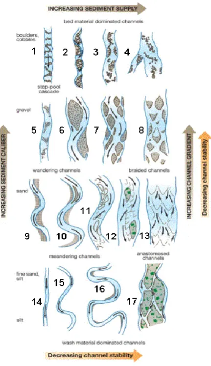
Across all of the channel patterns that have been recognized so far in the literature, two of the original patterns defined by Leopold and Wolman (1957) persist. A single-thread, sinusoidal pattern is still described as meandering, whereas a multi-thread channel supporting multiple mid-channel bars is described as braiding. However Schumm (1981, 1985) and Church (2002) developed additional channel styles that describe gradual rather than abrupt transitions between these two basic types and define additional single-thread and multi-thread patterns that encompass a wider range in the controlling factors (Figure 2.1). Whilst Schumm’s three types of load (sediment calibre) provide the fundamental discriminator between the 17 channel types (bed load—types 1-8; mixed load—9-13; and suspended load—types 14-17) displayed in Figure 2.1, gradient and sediment supply (a function of discharge and sediment sources) are also included as controlling factors. Figure 2.1 essentially describes a continuum of styles that can be broadly categorized into single-thread and multi-thread forms.
Single-thread channels include straight and sinuous channels. There are six types of straight channel displayed in Figure 2.1: those with (types 1, 2, 5) or without (type 14) exposed bedforms and with mobile alternating bars (types 6, 9). These grade into 4 types of sinuous channel: slightly sinuous channels of different stability (type 3, 15) and more sinuous, truly meandering channels of different stability (types 10, 16), where stability is essentially a function of sediment calibre (silty banks are more cohesive and stable than sandy-gravelly banks) and sinuosity is quantified (Kellerhals et al., 1976; Knighton, 1998) as:
Sinuosity = (channel length)/(straight-line valley length)
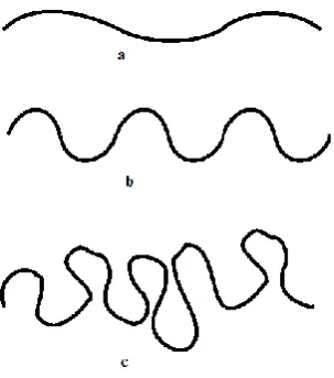
(2.1) Kellerhals et al. (1976) also defined three categories of degree of meandering: irregular meanders (Figure 2.2a); regular meanders with a clear repeating pattern and a maximum deviation angle of <90o (Figure 2.2b); and regular meanders with clear
29
29
Figure 2.2 Classification of degree of meandering (from Kellerhals et al., 1976)
Multi-thread channels were represented by a single ‘braided’ class by Leopold and Wolman (1957) but these are represented in Figure 2.1 by three main types (7, 8, 13) that vary with sediment calibre and two main transitional, island-braided types (11, 12). Anastomosing rivers (17) form an additional type of multi-thread river (type 17), which consist of multiple channels divided by vegetated, stable islands with no exposed unvegetated bars.
30
30
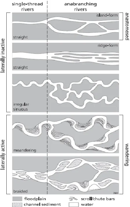
Figure 2.3 Alluvial river classification of single thread and related anabranching systems (from Nanson and Knighton, 1966)
31
31
2.2.2 A channel style continuum
Despite their three-fold channel pattern classification, Leopold and Wolman (1957) recognized that a continuum of channel styles existed and they tried to locate a transitional zone across which single-thread meandering rivers graded into multi-thread braiding rivers by estimating a power function that linked average channel slope (s) and bankfull discharge (Qb) (Figure 2.4 and equation (2.2)):
s = 0.006 Q−0.44b
32
32
Figure 2.4 Values of channel slope and bankful discharge from various natural channels and a proposed threshold between braided and meandering channel
planforms (from Leopold and Wolman, 1957)
Despite being less easily quantified, sediments are also significant factors determining channel patterns. Schumm (1963) noted an increase in planform sinuosity (S) with an increase in the silt-clay content (M) of the channel boundary sediments:
𝑆 = 0.94 𝑀0.25
(2.3) Bank resistance to erosion determines the ability of streams to shift laterally (Hickin and Nanson, 1984). Active meandering and braiding patterns evolve as a result of bank erosion, with active meandering developing as a result of bend development through bank erosion and deposition on opposing banks, and braiding resulting from channel widening and bend destruction. Straight, stable meandering and anastomosing rivers have been assumed to have stable banks because of their lack of lateral movement (Knighton and Nanson, 1993). Thus, Parker (1976) produced a regime diagram reflecting bank erodibility, which plots sites according to two ratios: width:depth and slope:Froude number (Figure 2.5), where the following equation separates braided from meandering – straight channels.
𝑠 = 𝐹𝑑/𝑤
33
33
Figure 2.5 Discrimination of straight, meandering and braided channels and also the degree of braiding based on the ratios of slope:Froude number and
depth:width (from Parker, 1976)
More recent research on identifying the threshold slope for these channel patterns has also demonstrated how bed material size (D50) determines braided and single-thread
channels. Van den Berg (1995) classified braided and sinuous channels (S>1.3) using a plot of specific stream power against median grain size. This approach was extended by introducing a range of landforms associated with these channel styles: scroll bars, chute bars, and scrolled point bars (Figure 2.6).
The discriminator between predominantly braiding and meandering channels
(bm) was found to be:
𝜔𝑏𝑚= 900𝐷500.42
34
34
Figure 2.6 Channel patterns in relation to gradients in grain size and unit stream power (from Kleinhans and Van den Berg, 2011)
Whereas the discriminator for low energy stable channels occurs at an order of magnitude lower stream power,ia (Makaske, et al., 2009) is defined as:
𝜔𝑖𝑎 = 90𝐷500.42
( 2.6 ) A transition between meandering rivers characterized by scrolls and by scrolls and chutes is found between equations ( 2.5 ) and ( 2.6 ) and is defined as:
𝜔𝑠𝑐 = 90
√10𝐷50
0.42 ≈ 285𝐷
500.42 ( 2.7 )
Single-thread rivers: planform and controlling factors 2.3
Single thread rivers form the focus of this thesis, so this section explores their planform and controlling factors in more detail from both theoretical and observational perspectives. In doing this, meandering rivers are a particular focus and a range of characteristic morphological features are also revealed that may relate to single thread
Eq. 2.5
Eq. 6 Eq. 2.7
Eq. 6 Eq. 2.6
35
35
rivers of different types. Meandering rivers are a very common river planform characterised by planimetric evolution that involves meander migration, growth, and cutoffs. Well documented examples include the Amazon River (Puhakka et al. 1992), the Congo River (Peters, 1978), Yellow River (Wang et al., 2004), Ob River (Alabayan and Chalov, 1998), and Brahmaputra river (Coleman, 1969; Jagers, 2003). Within this class of river planform there are many variants and there are no well-developed morphological models capable of fully representing large-scale planimetric changes of this style of river.
2.3.1 Characteristics of sinuous to fully meandering rivers
The planimetric form of a meandering river is sinuous with successive inflection points and meander bends, whilst the longitudinal bed profile is characterized by alternation between pools and riffles or runs (Figure 2.7). Riffles (rough water surface characterized by standing waves) or runs (water surface characterized by ripples) are shallow zones with fast moving water that are mainly located at planform inflection points. Conversely, pools are deeper areas with a smooth water surface and relatively slow moving water (Crosato, 2008). The plan and geometry of meanders has been described and quantified by many researchers.
36
36
a) Planimetry
Channel sinuosity (S) is the ratio between channel thalweg length (LT) and valley
length (L0) (Rust, 1978):
S = LT / L0 ( 2.8 )
Brice (1984) proposed that meandering rivers have a sinuosity that exceeds 1.25, whereas Leopold et al. (1964) and Rosgen (1994) suggested a value exceeding 1.5. The latter threshold has become the most widely used definition, since meander river planimetry can be considered to consist of a series of opposing semicircles and thus a sinuosity /2 = 1.57.
Meander wavelength (Figure 2.8) refers to a pair of opposing meander loops (Leopold et al., 1964). According to Friedkin’s (1945) laboratory experiments, meander wavelength is influenced by the hydraulic river regime, sediment, valley slope and upstream and downstream conditions. Leopold and Wolman (1960) also noted the proportionality of wavelength to channel width, quantifying a ratio of 10.9 between meander wavelength (L) and the product of sinuosity (S) and channel width (B), whereas Garde and Raju (1977) suggested a value of 6:
𝐿 = (10.9 𝑜𝑟 6)𝑆𝐵 ( 2.9 )
Wave number () is a dimensionless meander property that is used in theoretical analyses of meandering, which expresses the ratio of reach-averaged width (W) to meander wavelength (L):
𝜆 = 𝜋𝑊 𝐿⁄ ( 2.10 )
Camporeale et al. (2005) found from an analysis of 44 real river reaches that the width of the meander belt/amplitude (W) is approximately 40 to 50 times the spatially-averaged linear wavenumber (m) ̅:
𝑊 = (40 − 50)𝜆̅
37
37
Figure 2.8 Meander geometry sketch (from Leopold et al., 1964)
38
38
Figure 2.9 Single-thread alluvial river patterns with classes categorized according to the distribution and degree of spatial variation in channel width (modified from
Brice, 1975 by Lagasse, et al., 2004)
39
39
Figure 2.10 Wave number distribution of bends for wider-at-bends (class C) and
equi-width meandering channels (class B1) (from Lagasse et al., 2004)
In reality, meanders can be either regular or irregular (Figure 2.11A) and regularity may not be strictly preserved over distance, so that meanders may not be completely regular or solely random and there can be considerable variability between the two within and between meander systems (Ferguson, 1979).
b) Meander geometry
Meander geometry has been investigated using two methods. First is the traditional approach that is based on measures extracted for individual bends, such as meander wavelengths () and radius of curvature (rc), and then averaged over sequences
of bends (Figure 2.11B). The second analyses series of meanders, investigating the stream trace as a spatial series of direction () or direction change () with respect to distance (x) (Figure 2.11C and D).
Ferguson (1975, 1979) suggested the subdivision of meandering into three properties: a scale variable such as wavelength ( or *), sinuosity or wiggliness, and
40
40
Figure 2.11 Meandering patterns: (a) Degree of meandering; (b) Standard sketch of meander bends with key meander properties; (c) Quantifying meander path
direction () and change of curvature (): (d) Planform geometry and spatial
distribution of curvature (i) regular meander (from Langbein and Leopold, 1966) (ii) irregular meanders of the River Trent (from Ferguson, 1979)
41
41
𝜃 = 𝜔 sin 𝑘 𝑥
( 2.12 ) The channel direction () is presented as a sinusoidal function of distance (x), is the angle formed between the channel section axis and down valley axis, and k is 2π/λ* (see Figure 2.11D(i)).
Meander loops are individual meander bends (i.e. half a meander wavelength; Leopold et al., 1964) and four basic types have been identified (Figure 2.12): simple symmetrical, simple asymmetrical, compound symmetrical, and compound asymmetrical. A simple symmetrical loop is formed when a low symmetrical arc with constant curvature (increasing in height but decreasing in radius) grows and its length surpasses its radius. It becomes asymmetrical when the growth of a second arc is tangential to the first but also curved toward the same side of the stream. A simple loop becomes compound when the second arc is developed into a loop. Compound loops are considered to be deviant forms having indefinite radius and length. However, meandering patterns can be analysed by simple loops whose properties can be easily measured and treated statistically (Brice, 1974; Hooke and Harvey, 1983).
42
42
c) Bend Flow
Flow patterns in meandering rivers are governed by the sequence of opposing bends (Figure 2.13). Primary flow is two-dimensional water flow (obtained from depth-averaging) and consists of longitudinal and transverse components. Secondary flow includes the components of primary flow and all the deviations from it. It is a feedback process between centrifugal force caused by channel curvature, vertical gradient of the main flow and transverse inclination of water surface layer (which leads to transverse pressure gradients) (Rozovskii, 1957; Kalkwijk and de Vriend, 1980, de Vriend, 1981).
Centrifugal force pushes the water toward the outer bank, resulting in a higher water level on that bank and a transverse pressure gradient which pushes the water toward the inner bank. The centrifugal force is stronger near the surface and weaker close to the river bed. In combination with the pressure gradient, it results in a transverse current. The current is directed towards the outer bank close to the water surface and inwards close to the bed. The current is vertical in a downward direction near the outer bank and upwards near the inner bank. This transverse circulation combines with longitudinal (downstream) flow to produce helical flow (Figure 2.13b) (Crosato, 2008).
43
43
In relation to morphology, sediment is continuously carried towards the inner bank of the bend until an equilibrium condition between the drag force and gravitational force is established. This generates a triangular cross-sectional shape, with the deepest part towards the outer bank (pool) and the shallowest part towards the inner bank (point bar). Fully-developed bend flow cannot be reached in natural rivers, since channel geometry is not uniform along the longitudinal profile (Crosato, 2008).
d) Discharge
Rather than use the entire flow record, it is convenient to represent the discharge hydrograph by one or more simple indices of which the bankfull discharge (the discharge that fills the channel cross section without significant flooding of the flood plain) has been the most widely used (Leopold and Wolman, 1957; Ackers and Charlton, 1970b; Fredsøe, 1978; Hey and Thorne, 1986; Van den Berg, 1995). Bankfull discharge is a useful index of flow strength for meandering rivers. Since bankfull is not a frequent flow condition, it is best estimated from stage-discharge curves or as a 1.5 to 2 year return period ‘instantaneous’ peak discharge from a discharge time series
(Williams, 1978; Parker, et al., 2007).
e) Sediment
As a result of selective transport and abrasion processes, sediment tends to fine downstream along rivers. Most meandering rivers are located in lowland areas and are characterized by relatively fine (sandy to silty) river beds, although numerous natural meandering rivers have gravel beds, when they are either close to the braiding transition or are controlled by strong erosional process (Parker and Andrews, 1985; Parker, 1991; Seal et al., 1998; Ferguson et al., 1998; Gasparini et al., 1999).
44
44
This feedback process, which causes river bank accretion, is an important process in river meandering.
f) Channel Migration
Long term stationary meanders may display planimetric evolution that consists of a combination of translation and extension (Brice, 1984), known as channel migration. This process is based on sequences of bank erosion and accretion, which cause bank retreat and advance, respectively. As flow erodes the outer bank, causing local bank retreat, the eroded sediment deposits downstream at the inner bank (Friedkin, 1945), leading to point bar accretion and bank advance. The river remains meandering in planform because the bank advance process is counterbalanced with bank retreat in the opposite bank. If this does not occur, the river either becomes braided or anabranched or fills with silt and narrows.
Hooke (1980) compared historical bank retreat rates of rivers in Devon, UK with published data from rivers across the world, where data of mean river width, discharge, extension of drainage area, local radius of curvature and bank characteristics for a few of cross sections were reported.
Meander migration is a discontinuous process. High infrequent flows cause the channel to expand through bed erosion and raise channel margin elevations, while low frequent flows are associated with aggradation. Both processes reallocate the thalweg towards the eroding bank. Overall the meander migration process is governed by sequences of bank erosion and accretion accompanying series of high and low discharges and reinforced by the presence of riparian vegetation (Nanson and Hickin, 1983; Pizzuto, 1994).
45
45
Figure 2.14 Meander neck cut off process (image credit: Bruce Railsback)
g) Cutoffs
Meander migration and cutoff processes are drivers of changes in channel morphology, sediment load and habitat qualities of alluvial floodplain rivers. Predicting and allowing for their occurrence is one of the greatest challenges for meandering river managers, and to allow a balance between ecological function, flood protection and water supply (Micheli and Larsen, 2011).
Meander neck cutoff (Figure 2.14) occurs when meander extension is discontinued by flow excavation of the upstream outer bank until it connects downstream. This leaves the old bend abandoned as the flow progressively moves into the newly connected channel until it becomes the main channel. The new channel is generally shorter, straighter, and steeper and supports faster flow velocities than the old bend (Jagers, 2003).
46
46
(dynamically) constant and can be considered a stabilizing phenomenon for meandering dynamics in the long-term.
Channel morphological adjustments were demonstrated after both neck and chute cutoffs on River Bollin and Dane, UK (Hooke, 1995). The occurrence of multiple cutoffs was investigated through historical images by Hooke (2004), who assumed that cutoffs are a part of a self-organizing (river) system and that they occur because the river has reached a critical state.
h) Channel width dynamics and curvature
Field observations of rivers with cohesive banks (Pizzuto and Meckelnburg, 1989) support the idea that meandering channel width is constant in time and space due to an equal rate of bank retreat and advance. The most well-known geometrical classification of single-channel river patterns (Brice, 1982) emphasizes differences in the degree and the nature of channel width and curvature variations, where curvature and width are seen as deviations from a straight equiwidth channel pattern. Relationships between channel curvature and width variations may occur due to counterbalanced feedback process, which finally resulting in a variety of meandering behaviour (Zolezzi et al., 2009). The mechanistic evolution of curvature in meanders has been well researched (Ferguson, 1973; Blondeaux and Seminara, 1985); but the morphodynamics of spatial width variations in single-thread channels are less well understood, and thus understanding of the role of spatial variations in channel width in meander morphodynamics is also limited. Figure 1.8 implies that there might be a systematical variation of channel width along the meander wavelength: equiwidth single-thread streams (Figure 1.8 A, B1, G1, F); wider-at-bend streams (Figure 1.8 B2, C, D, G2) and irregular width streams (Figure 1.8 E). According to Brice (1982), the highest morphological activity is relevant to local bend widening, with most stable meandering channels showing little variation in width. High meander migration rates are usually associated with wider-at-bend streams (Lagasse et al., 2004).
2.3.2 Key factors controlling meandering
Several factors control natural meandering both explicitly and implicitly: flow strength, sediment supply, bank erodibility and riparian vegetation.
a) Flow strength
47
47
stream power, and temporal discharge variations, and it can be used to classify river types. In general, meandering rivers have lower flow strength than braided rivers.
b) Sediment supply
Meandering rivers are associated with the transport and deposition of significant quantities of fine (silt and clay) sediment, giving them generally cohesive bank even when they support a gravel bed, whereas braided rivers are characterized by sand and gravel and thus less cohesive banks. A relationship between channel pattern and sediment supply has been proposed by several authors (ASCE Task Committee, 1982). Braided rivers require a high sediment supply. When load decreases, rivers tend to become incised and start to meander (Schumm, 1981). Braiding is supported by bed aggradation, which occurs when bed material supply is larger than the river’s ability to
transport it (transport capacity). Stable meandering generally occurs when sediment supply is equal to or less than the river’s transport capacity.
c) Bank erodibility
Meandering river and other sinuous single-thread rivers are considered to have banks of relatively low erodibility as a result of soil cohesion, but this may also be attributable to well-developed riparian vegetation. Because meandering river banks are relatively cohesive, bank material entrainment is comparatively smaller than in braided rivers. Because of high bank cohesion, bank recession generally result from toe erosion followed by bank failure on meandering rivers. Smith (1998) explored this in a laboratory flume containing a very sinuous meandering river with slowly-migrating thalweg. Cohesive sediment ensured that the banks were resistant to erosion and the laboratory experiment suggested that bank erosion resistance to erosion strongly controlled river pattern, particularly sinuosity. Natural rivers show similar behaviour, implying that erodible banks are a key characteristic of braided rivers whereas resistant cohesive banks are typical of meandering rivers (Simpson and Smith, 2000).
d) Riparian vegetation
The importance of riparian vegetation for channel morphology has been demonstrated across a wide range of timescales and across laboratory and field spatial scales.
48
48
during the Permian-Triassic period (251 million years ago) in South Africa was attributed by Ward et al. (2000) to the devastation of plants. Furthermore, Davies and Gibling (2009, 2010) noted that during the Paleozoic, rivers across the Earth’s surface changed from predominantly braided to increasingly meandering forms as rooted vegetation capable of stabilizing river banks evolved. Laboratory experiment suggests the strong effect of vegetation presence on stream morphology, with a tendency to transform river pattern from multi- to single-thread (Gran and Paola, 2001). Flume experiments on braided rivers have shown how the presence of plants decreases the braid number (Kurabayashi and Shimizu, 2003) and how braided channels without vegetation transform into incised meandering as the banks become vegetated (Jang et al., 2003; Tal and Paola, 2005). Moreover, field observations indicate how riparian vegetation causes channel width to decrease (Eschner et al., 1983; Beeson and Doyle, 1995; Allmendinger et al., 2005). Importantly, Millar (2000) defined a bank stability criterion, incorporating riparian vegetation into the assessment of bank strength, that separates meandering from braiding channels and identifies channels where riparian vegetation is critical for maintaining a meandering rather than a braided pattern (Figure 2.15).
49
49
Figure 2.15 Planform stability diagram plotting (a) data from rivers with sparse bank vegetation and (b) data from rivers with dense bank vegetation. (open symbols are meandering rivers and solid symbols are braided rivers; rivers in
areas I and III are meandering and braided, respectively, regardless of bank vegetation, whereas rivers in area II will only meander if they have dense,
deep-rooted bank vegetation) (from Millar, 2000).
Single-thread rivers: bars and other geomorphological features 2.4
The preceding sections have considered the continuum of channel patterns that rivers may display, with a particular emphasis on single thread sinuous-meandering patterns (section 2.2); and then have focused on single-thread sinuous-meandering planforms and their controlling factors from both theoretical and descriptive-observational perspectives (section 2.3). Throughout these sections, a range of geomorphic features have been mentioned, which may allow discrimination between different river types, suggesting that recognising an assemblage of such features might also be the basis for classifying single-thread rivers. The presence and type of bars is particularly informative, since these are a fundamental feature of alluvial channels. ‘The presence of channel banks gives rise to a class of large-scale bed form called bars, the dimensions of which are controlled by the flow width as well as the depth’ (Bridge
2003, p141).
50
50
bars are simple forms composed of one main depositional feature, whereas compound bars reflect multiple phases of deposition and reworking under a range of flow conditions and thus are comprised of multiple units (Smith, 1974, Brierley, 1996). Descriptions of bar position include side bars and mid-channel bars. Linking bar shape and position leads to the identification of specific types of side bar associated with river bends, particularly on meandering rivers (point and counterpoint bars positioned, respectively, on convex and concave banks), sequences of bars along opposing channel margins of straight or sinuous rivers (alternate bars), and the general term lateral bar which refers to any bank-attached bar along a river margin, particularly those not directly associated with river bends. A particular type of bank-attached bar that crosses the channel is the diagonal bar, which is often associated with the cross-over point of river meanders. Finally, there are mid-channel bars, which are not attached to the banks, and are distinguished according to their orientation and shape into longitudinal (main axis parallel to the banks), transverse (main axis at an angle to the banks) and complex.,including found on transitional, wandering and braided rivers, linguoid bars are often recognised as a characteristic bar shape. The classification of bars is an extremely complex subject (e.g. Bridge, 2003), that goes beyond the scope of this thesis, and so the above represents one simple approach to classification. However, different broad types of bar (calibre/texture, position, shape) have been associated with different river styles, as illustrated earlier in this chapter (e.g. Miall, 1977, Schumm, 1985, Church 2006), and some of these may be distinguishable from aerial imagery, which forms the primary data source for this thesis (see Chapter 2).
51
51
Table 2.1 Bars and other geomorphic features of river channels and their floodplains (developed from Table 5.7 of Gurnell et al., 2014) Geomorphic
feature
Description Diagram Formation/typical setting Reference(s)
In -c ha nn el m argina l ba rs
Side bar Bank-attached bar, often distributed periodically along one and then the other side of channel to form alternate bars.
Plan view
Typically found in sinuous channels and indicative of secondary current
development and pool-riffle formation.
Church and Jones (1982)
Point bar Bank-attached arc-shaped bar developed along inside of river bends with bar surface towards channel and typically devoid of vegetation.
Plan view
Point bars are characteristic of actively meandering streams and tend to extend into the channel and
downstream, keeping roughly parallel with the eroding bankline.
Church and Jones (1982)
Scroll bar Elongated ridge-like bar formed along inside of meander bends, commonly on point bars. Often
contain trees deposited on point bars during floods and may develop into
vegetation-covered ridges. Plan view
Formed by deposition in the shear zone between the helical flow cell in the thalweg zone and flow in a separation zone adjacent to the convex bank of a bend.
52
52
Geomorphic feature
Description Diagram Formation/typical setting Reference(s)
In
-c
ha
nn
el m
argina
l
ba
rs
Counterpoint bar
Depositional feature consisting of typically finer sediment than that of point bars which
develops in the separation zone formed against the upstream limb of the convex bank of
tightly curving bends. Plan view
Often form on tight bends created when the river is constrained by the valley wall or a major terrace.
Hickin (1984); Lewin (1983); Page and Nanson (1982)
Berm/bench A step-like, sedimentary
feature located against the bank face with a relatively flat upper surface and steep edge sloping towards the channel.
Profile view
Formation occurs through aggradation and subsequent colonisation by vegetation of marginal bars.
53
53
Geomorphic feature
Description Diagram Formation/typical setting Reference(s)
In -c ha nn el mid -c ha nn el ba rs Mid-channel bar Depositional sedimentary feature in the mid-channel region around which flow diverts. Many sub-types exist (e.g. transverse, medial, diagonal, etc.) but all are exposed during normal flow conditions and submerged during bankfull flows.
Plan view
Formation can occur via a number of mechanisms ranging from a localised decline in competence leading to deposition of coarse material to chute cutoffs of point bars but presence indicative of high rates of sediment supply and transport.
Church and Jones (1982), Ashmore (1991)
Island Landform within the central channel region that is emergent at bankfull stage. Island surface is usually aggraded to floodplain level and covered by vegetation.
Plan view
Formation can occur via a number of mechanisms including floodplain dissection and continued deposition of fine sediment on bar surfaces (often aided by vegetation).
54
54
Geomorphic feature
Description Diagram Formation/typical setting Reference(s)
Cascade Non-alluvial features composed of large boulders that are partially emergent during low and intermediate flows with small (i.e. diameter less than channel width) intervening pools characterised by highly turbulent flow. No systematic lateral or
longitudinal organisation.
Profile view
Plan view
Cascades are typically found in very steep and confined channels with high
contemporary or historic coarse sediment supply rates.
55
55
Geomorphic feature
Description Diagram Formation/typical setting Reference(s)
Rapid Semi-alluvial features in which boulders are organised into irregular lines oriented
approximately perpendicular to the channel and that either partially or completely span the width of the channel. Small, shallow pools may be evident between the boulder lines but
they are poorly developed. Profile view
Plan view
Rapids are typically in steep and confined channels, but where gradients are lower than for cascades.
56
56
Geomorphic feature
Description Diagram Formation/typical setting Reference(s)
Step A channel-spanning linear accumulation of coarse sediment (typically
boulders/cobbles). Usually associated with a distinct downstream pool that is
scoured by water plunging over the step.
Profile view
Sequences of steps and pools are steep upland channels with coarse beds. Step-pool sequence repeats with a mean spacing of 1-4 times the mean channel width.
Chin (2003); Halwas and Church (2002)
Riffle Accumulations of coarse sediment (typically pebbles and cobbles) associated with rapid, shallow flow and disturbance of the water surface. Regularly interspersed by pools.
Profile view
Characteristic feature of gravel bed meandering streams. Tend to occur at inflection points between meanders and pool-riffle sequence repeats with a mean spacing of 5-7 times the mean channel width, indicating initial formation is linked to large-scale turbulent eddy patterns.
57
57
Geomorphic feature
Description Diagram Formation/typical setting Reference(s)
Plan view
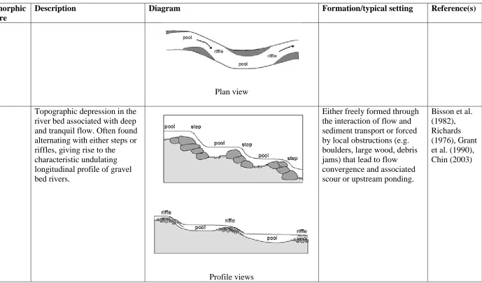
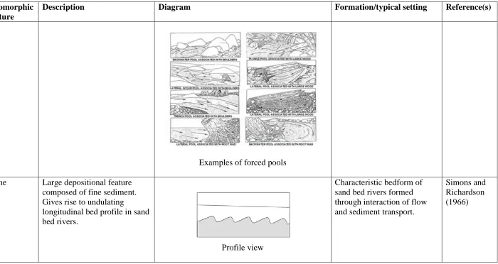
Pool Topographic depression in the river bed associated with deep and tranquil flow. Often found alternating with either steps or riffles, giving rise to the characteristic undulating longitudinal profile of gravel bed rivers.
Profile views
Either freely formed through the interaction of flow and sediment transport or forced by local obstructions (e.g. boulders, large wood, debris jams) that lead to flow convergence and associated scour or upstream ponding.