APPLICATION OF USING GLOBAL
POSITIONING SYSTEM (GAS) IN
DETERMINED A LOCATION
YUNOS NGADIMAN
THE 4
t hASIAN CONFERENCE ON INDUSTRIAL
AUTOMATION AND ROBOTICS
11 - 1 3 MAY 2005
APPLICATION OF USING
GLOBAL POSITIONING SYSTEMS (GPS) IN DETERMINED A LOCATION
YUNOS BIN NGADIMAN
Faculty of Technology Management Kolej Universiti Teknologi Tun Hussein Onn
86400 Parit Raja, Batu Pahat, Johor. Tel: +607-453-8125 Fax: +607-454-1245
Email: [email protected]
ABSTRACT
Global Positioning Systems (GPS) are navigation tools that allow users to determine their location everywhere in the world at any time of the day. GPS Systems use a satellite network of 24 satellites to establish the position of indiviual users. This paper will describe how the GPS system works and factors can degrade the GPS signal accurately. Originally the systems are developed by the military, widely utilized by commercial users and private citizens especially in developed country such as EU countries, USA and Japan. GPS was originally designed to aid in navigation across large spaces or through unfamiliar territory. As a tool for law enforcement, GPS systems are able to assist for commercial and private users to enjoy the ability of accurately navigate everywhere in the world. Finally, corporations are developing GPS is very essential to widely utilise in our country as well as a way to enhance customer service, to track inventory and very powerful security investigation systems.
Keywords: GPS, Navigation Tool, Investigation Systems.
1.0 Introduction to GPS
Figure 1: GPS Satellite
The GPS system was designed by and is controlled by the United States Department of Defense and can be used by anyone, free of charge. The GPS system is divided into three segments: space, control, and user. The space segment comprises the GPS satellite constellation. The control segment comprises ground stations around the world that are responsible for monitoring the flight paths of the GPS satellites, synchronizing the satellites' onboard atomic clocks, and uploading data for transmission by the satellites. The user segment consists of GPS receivers used for both military and civilian applications.
The cost of maintaining the system is approximately US$400 million per year, including the replacement of ageing satellites. The first of 24 satellites that form the current GPS constellation was placed into orbit on February 14, 1989. The 52nd GPS satellite since the beginning in 1978 was launched November 6, 2004 aboard a Delta II rocket.
Each satellite transmits a message containing three pieces of information, the satellite number, it position in space and the time at which the message was sent. The GPS receiver reads the message and saves the information.
The GPS receiver can compare the time at which a signal was transmitted by a satellite with the time it was received by the GPS receiver. This allows it to determine how far away that particular satellite is.
Pointl •
With distance measurements from four satellites, the position from on the ground can be calculated. Consider the diagrams shown here.
The figure 2 shows two known positions, 'Position 1' and 'Position 2' at the dots. The circles show all points at known distances 'dl' and 'd2' from them. These are the data that the GPS receives from the orbiting satellites. There are two possible locations that are the specified distances from the two locations. These are shown by the points where the two
circles overlap.
The figure 3 shows an additional point, 'Point 3' and all positions a known distance 'd3' from it. See how this additional information allows us to identify a single location on the page.
So in two dimensions, on a plane, three sets of known locations and distances are required to uniquely identify a point in space.
PoMla
Point2 •
42 Point 3 a
In three dimensional spaces, such as the in which we live and the satellites orbit, four sets of positions and distances are required to uniquely identify a location. When using GPS, the more that are known the better to overcome errors in measurement.
Figure 3
2.0 How GPS Works & Basic Navigation
The basis of the GPS technology is a set of 24 satellites that are continuously orbiting the earth. These satellites are equipped with atomic clocks and send out radio signals as to the exact time and location. These radio signals from the satellites are picked up by the GPS receiver. Once the GPS receiver locks on to four or more of these satellites, it can triangulate its location from the known positions of the satellites.
Regarding the issue of time, UTC time is the basis of all GPS time functions and calculations. If nothing else, in owning a GPS receiver, you have in your possession the most accurate time piece available. Your receiver updates itself from the atomic clocks on the satellites. It is also very important for you to understand that your receiver must know the time difference between your location and of Greenwich England or UTC time. This is a function in the set-up of all GPS receivers. With many GPS manufacturers, this is referred to as Offset which is referring to the offset or difference in time zones from the present location to UTC time.
3.0 Accuracy of GPS
Today's GPS receivers are extremely accurate. The accuracy of the receivers is dependent on the number and quality of the signals getting from the satellites and from a factor called Selected Availability (SA).
Selected Availability is an intentional error that is introduced into the signals coming from the Satellites that create readings that can be off as much as 300 feet. Even so, the accuracy levels with SA turned on, is usually within 100 feet.
The other factors affect the accuracy of GPS are quality of GPS signals from the satellites and operator error. The operator error can include such things as inputting the wrong values for position coordinates and as using the wrong datum for the map being referenced.
4.0 GPS Receiver Set-Up
To be able to properly use a GPS receiver, it needs to be set-up and initialized. Set-up establishes the basic information about the units of distance, speed, Map Datum, Navigation Grid system, time difference from Greenwich England or UTC time, and other basics.
The user's manual that comes with each GPS receiver gives detailed instructions on the process of selecting the options for initialization and set-up. This must be done to be able to use the unit for navigation.
5.0 Summary of Basic GPS Use
For Basic GPS use, you only need to understand the most basic of the receiver's functions. Set-up and initialization functions, Saving a Waypoint, and using the GOTO feature. For this level of use, you don't need to understand the coordinate grid systems, datums or how to use maps. Therefore, a new GPS user can make good use of the unit with the minimal amount of experience reading the manual and working the menus and keypad.
5.1 The Latitude/Longitude Grid System
The two most common grid systems in use in North America and are referenced on maps are the Latitude Longitude (Lat/Long) grid and the Universal Transverse Mercator (UTM) grid. The Lat/Long grid has been in use for centuries and most people have heard of the basic terms of latitude or longitude.
The UTM grid is a metric grid system based on 60 grid zones around the globe and a set of values in meters from reference points of the grid. There are some aspects to this grid that make it very simple and easy to use even though the basic terminology is foreign to most people.
We will discuss the principles of how these two grids are set up and used to determine a set of coordinates for an exact location.
Any grid consists of reference points, units of measurement, and some designation of direction to clearly identify a position.
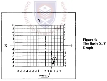
A classic example is the basic X, Y graph as seen in Figure 4 below. The horizontal line is the "X" axis and the vertical line is the "Y" axis. The two axis are the reference points. Direction is indicated by + and - on either side of the axis. Therefore, the Point "A" would be defined as +5,-4.
6 5 4 3 2 1 V
T {
6 6 5 4 3 2 1 V 5 4 3 2 1 A 6 5 4 3 2 1 V 5 4 3 2 1 A 6 5 4 3 2 1 V 5 4 3 2 1 A 6 5 4 3 2 1 V 5 4 3 2 1 A 6 5 4 3 2 1 V 5 4 3 2 1 A 6 5 4 3 2 1 V 5 4 3 2 1 A A - 1 • 2 - 3 - 4 - 5 • 6 - 1 • 2 - 3 • 4 - 5 - 6 A - 1 • 2 - 3 - 4 - 5 • 6 - 1 • 2 - 3 • 4 - 5 - 6 A - 1 • 2 - 3 - 4 - 5 • 6 - 1 • 2 - 3 • 4 - 5 - 6 A - 1 • 2 - 3 - 4 - 5 • 6 - 1 • 2 - 3 • 4 - 5 - 6 A - 1 • 2 - 3 - 4 - 5 • 6 - 1 • 2 - 3 • 4 - 5 - 6 A - 1 • 2 - 3 - 4 - 5 • 6 - 1 • 2 - 3 • 4 - 5 - 6 A - 1 • 2 - 3 - 4 - 5 • 6
. 7 . 6 .5 4 - 3 - 2 - 1 1 2 3 / 4 5 6 7
[image:6.597.150.502.367.634.2]Point "A" j
Figure 4: The Basic X, Y Graph
things about this grid in that it is spherical instead of flat and the units of measure are ANGULAR in Degrees, Minutes and Seconds.
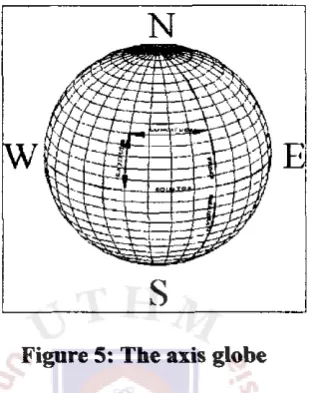
Figure 5 shows the axis on the globe.
[image:7.596.235.391.195.392.2]The significant issue than must be understood in using the Lat/Long grid is that the units of measurement are defined in Degrees.
Figure 5: The axis globe
Almost everyone knows that a circle is divided into 360 degrees. In working with the Lat/Long grid, we are dealing with a sphere where the reference axis are two circles. The one circle is around the center of the globe at the equator, and the other running vertical or North and South at the Prime Meridian. The angular measurement is considered from the center of the earth for both of these
[image:7.596.236.382.541.686.2]reference circles.
Figure 6 shows a simplified view of the angular measurement from the Equator and Prime Meridian with the center point of these reference circles being in the center of the earth.
NORTH POLS
SOOTH POLK
O R 9 0 S
AXIS OF THE LAT./LONG GRID
Much like our X, Y graph, we define a point by a given distance in degrees East or West from the Prime Meridian and in degrees North or South from the Equator. This is illustrated in the example on Figure 5 showing a given point of Latitude and Longitude.
Another important issue needs to be understood is about angular measurement which is the fact that if we were only using degrees, we would not be very accurate because one degree of longitude or latitude at the axis is equal to approximately 69 statute miles. Therefore, the circle needs to be divided into smaller components to give us more accurate coordinates. So, the Degree has been divided into 60 smaller units called Minutes and furthermore, these Minutes are divided into 60 Seconds (nothing to do with time).
6.0 Techniques to improve GPS accuracy
The accuracy of GPS can be improved in a number of ways:
• Using a network of fixed ground based reference stations. These stations broadcast the difference between the measured satellite pseudoranges and actual (internally computed) pseudoranges, and receiver stations may correct their pseudoranges by the same amount. This method is called Differential GPS or
DGPS. DGPS was especially useful when GPS was still degraded (via the "Selective Availability" described below), since DGPS could nevertheless provide 5-10 metre accuracy. The DGPS network has been mainly developed by the Finnish and Swedish maritime administrations in order to improve safety in the archipelago between the two countries.
• Exploitation of DGPS for Guidance Enhancement (EDGE) is an effort to integrate DGPS into precision guided munitions such as the Joint Direct Attack Munition (JDAM).
• A Local-Area Augmentation System (LAAS). This is similar to WAAS, in that similar correction data are used. But in this case, the correction data are transmitted from a local source, typically at an airport or another location where accurate positioning is needed. These correction data are typically useful for only about a thirty to fifty kilometre radius around the transmitter.
• Wide Area GPS Enhancement (WAGE) is an attempt to improve GPS accuracy by providing more accurate satellite clock and ephemeris (orbital) data to specially-equipped receivers.
• Relative Kinematic Positioning (RKP) is another approach for a precise GPS-based positioning sytem. In this approach, accurate determinination of range signal can be resolved to an accuracy of less than 10 centimeters. This is done by resolving the number of cycles in which the signal is transmitted and received by the receiver. This can be accomplished by using a combination of differential GPS (DGPS) correction data, transmitting GPS signal phase information and ambiguity resolution techniques via statistical tests - possibly with processing in real-time (real-time kinematic positioning, RTK).
• Many automobile GPS systems combine the GPS unit with a gyroscope and speedometer pickup, allowing the computer to maintain a continuous navigation solution by dead reckoning when buildings, terrain, or tunnels block the satellite signals. This is similar in principle to the combination of GPS and inertial navigation used in ships and aircraft, but less accurate and less expensive because it only fills in for short periods.
7.0 Applications
[image:9.597.160.433.516.690.2]The primary military purpose is to allow improved command and control of forces through an enhanced ability to accurately specify target locations for cruise missiles or troops. The satellites also carry nuclear detonation detectors, which form a major portion of the United States Nuclear Detonation Detection System.
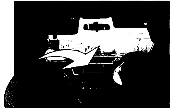
Most of taxi in Japan equipped with GPS navigation as in Figure 7, is an example of how
[image:10.596.195.419.124.286.2]GPS technology can improve everyday life.
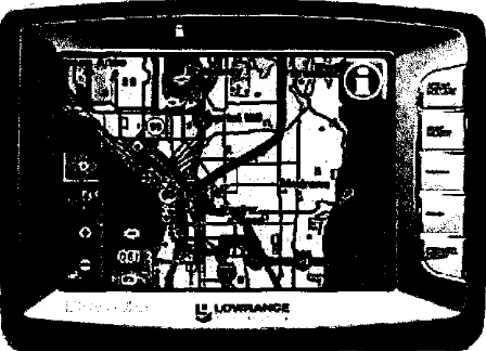
Figure 8: Lowrance iWay 500c Portable Vehicle Navigation System
The Figure 8 shows a model sample of portable vehicle navigation system. The system is used by countless civilians as well, who can use the GPS's Standard Positioning Service worldwide free of charge. Low cost GPS receivers (price US$100 to US$200) are widely available, combined in a bundle with a PDA or car computer. The system is used as a navigation aid in airplanes, ships and cars. The system can be used by computer controlled harvesters, mine trucks and other vehicles. Hand held devices are used by mountain climbers and hikers. Glider pilots use the logged signal to verify their arrival at turn points in competitions.
8.0 Conclusion
References
1. El-Rabbany Ahmed (2004); "Introduction to GPS: The Global Positioning Syatems"; Artech House Publication, Boston.
2. Guochong Xu (2003); "GPS: Theory, Algorithms and Applications"; Springer-Verlag Publication, Berlin.
3. Kaplan, Elliott D (1996); "Understanding GPS: Principles and Applications"; Artech House Publication, Boston.
4. Leick, Alfred (1995); "GPS Satellite Surveying"; John Wiley, New York.
5. website http://www.gisdevelopment.net
6. website http://www.geog.le.ac.uk