Available Online at www.ijpret.com 1805
INTERNATIONAL JOURNAL OF PURE AND
APPLIED RESEARCH IN ENGINEERING AND
TECHNOLOGY
A PATH FOR HORIZING YOUR INNOVATIVE WORK
REAL TIME TRACKING SYSTEM USING GPS
PURVESH BORKAR, MANOJ PUNDE, VISHAL VYAVAHARE, KISHOR WAKCHAURE
Research Scholar, University of Pune, Pune
Accepted Date: 05/03/2015; Published Date: 01/05/2015
Abstract: Public transportation is highly cost effective and environmental friendly solution
for commuters. But the unreliability of the system because of lack of communication often prevents its widespread use. This paper describes the solution which makes the public Transportation more intelligent. The emphasis of this paper is on prediction of the bus arrival time, distance and geo-location based on various aspects like bus availability, average running speed and bus current location. For analysing these aspects, we have developed range of algorithms which includes dividing routes into segments, mapping bus location onto segment and finding accurate information for user’s query. Required resources are classified into two modules namely the GPS(Global Positioning System) module for tracking the bus’s potential GPS logs and the network infrastructure that allows the users to communicate, for enquiring for the bus information and receiving response on different platform like Android and SMS.
Keywords: Intelligent Transportation System, Travel Time Prediction, Bus Tracking, Global
Positioning System (GPS), Real Time Tracking System, Android, Bus, Short Messaging Service (SMS).
Corresponding Author: MR. PURVESH BORKAR
Access Online On:
www.ijpret.com
How to Cite This Article:
Purvesh Borkar, IJPRET, 2015; Volume 3 (9): 1805-1815
Available Online at www.ijpret.com 1806 INTRODUCTION
Passengers in Metro cities often faces problem of uncertainty of public transportation system. This leads to heavy usage of private vehicles leading to more traffic problems. The reason to this is unavailability technology-systems in India which gives accurate information. Providing real-time bus arrival information would enhance the credibility of the public transit system and thus render it more competitive among various transportation modes. If commuters had an easy way to see which bus is near to their location and approximate time it would take to reach the stop, in real time, they could make a more accurate, decision of whether or not to wait at a stop.
One important parameter in travel time prediction model is travel time data. Travel time data can be obtained through various traffic surveillance devices. With the emergence of Global Positioning System (GPS) technologies, traffic data collection can be performed more efficiently and safely. GPS provides us with a more perfect and convenient way for the travel time predication Application development.
A technology central to several functions of real time tracking system is the GPS. Advancement in mobile computing has made possible transmission of GPS data for long distance transmission in real time. GPS and Geographic Information System (GIS) combined together provide us with visualization of vehicular movements and tracing them to the global position.
This paper emphasizes on a simulation model consisting of an application that allow the user to get the current details of the bus they are interested in. And for this purpose we have developed an android application and a Short Messaging service application that allows the user to send request for the destination stop and as a response to this the server sends an estimated prediction arrival time for the user enquired bus.
The primary goal of this simulation research is to enable passengers to easily access estimated bus arrival time they are interested in. Along with this the user is also made available with a real time bus marking for each of the bus on map with a label that identifies the location of each bus.
BACKGROUND AND RELATED WORK
Available Online at www.ijpret.com 1807
a. Implementation requires genuine study of the traffic hours; this is due to the tremendous fluctuation in the traffic on the roads.
So a detailed analysis of the various hours is considered, giving us the speed required to cover the distance during the various hours of the day.
b. Secondly while giving the response to the user, number of validation needs to be considered like
If the bus has already passed the user requested pickup bus-stop, Is the bus running today or is cancelled, etc. Changes made in bus route.
After validating all this factors the model-server has to calculate the bus arrival time for the user requested location. And then forward the calculated values to user-response with following considerations- Continuously updating the GPS logs for each bus.
Maintaining the proper hierarchy of the GPS data record files for the analysis.
Showing the continuous update of the intended bus on the Google map to the user adds excitement to the model ussage.
Architecture Design:
The architectural design gives a brief idea about the details of the system Design.
The GPS enabled devices keep forwarding the data continuously to the application server. Based upon the request from the user the application server sorts out the required bus details and then forwards the calculated details to the user.
The database stores all the static data related for details calculation. The user specifies its request through an Android application or Short messaging service aggregator.
The Google API’s helps in more proper speculation of the required information.
Available Online at www.ijpret.com 1808 Fig. 1: Architecture design of the Real Time Tracking system.
Model Simulation-
For testing purpose five sample routes of Pune City (India) are considered. All the GPS logs are collected in real time using GPS enabled mobile. Project model is developed into three main tasks phases namely:
Route organization.
Development of the server side Program.
Communication between the Server System and the User.
Route Organisation:
In order to calculate the distance between two earth position the Haversine formula is used based on the latitude and longitude. But the formula gives the distance is in one straight line between two points on the globe. So for real time implementation the route has to be divide into number of small segments, each of the segments is called as links. Each of these segments is of 100 meters approximately. The routes with their intermediate stations are stored within a file along with their latitude and longitude in the sequence of arrival for the bus in one direction.
Route link development allows us for calculation of the bus arrival time and for identifying the nearest bus stop within the current bus position radius.
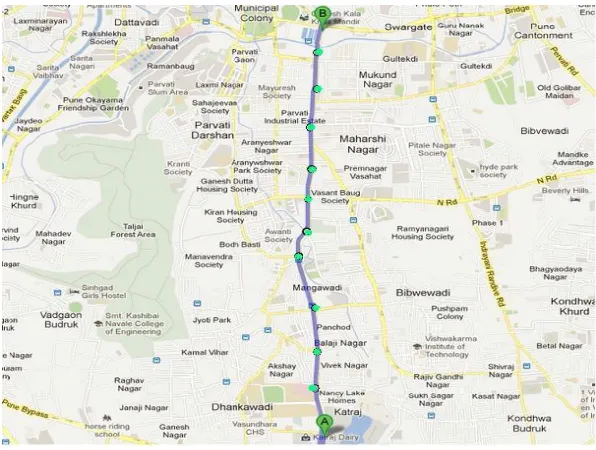
Available Online at www.ijpret.com 1809 Fig. 2: Route Segments along with Katraj and Swargate Stops, Pune.
Computation on Server Program:
The sever side functionalities are divided into number of tasks namely:
Collection of the GPS logs:
The system tracks vehicles, by using an on-vehicle GPS-based vehicle computer, which transmits vehicle position data to a central station, those details are being used by the system continuously in order to calculate the current location of the bus and predicting the arrival time. This information is made available to the information system. The GPS log also allows to locate the current bus position on the map.
The GPS logs are stored into a file data structure. Each record consists of the GPS identification, time label, latitude and the longitude of the bus location.
Obtaining the current bus Direction:
Available Online at www.ijpret.com 1810
wrong conclusion creating havoc to the user queries. So in order to get the right direction, along with the bus previous log details and schedule we need to compare itspreviously running station for the specific route and bus number along.
Real Time Bus Tracking:
Nearest Bus-Stop (link) for Current Bus Position:
In order to predict the arrival time of the bus we need to determine the exact location of the bus within their intermediate links along the bus route, which are statically stored, based on the current GPS location.
So here we calculate the nearest intermediate link by calculating the distance between bus current position and all of the links. Whichever link distance is the nearest is consider as the segment of the current bus.
This segment help to calculate the prediction travel time for each of the individual link on the remaining route for the respective bus.
Average Speed Derivation:
Looking toward the uncertain nature of the traffic condition, a great variance can be recorded. Therefore it is necessary to estimate average traffic time spend by the bus during the various hours of day. The main traffic seen on the road is because of the official working peoples going on their regular routine. During the official hours the traffic is comparatively very low that of the office starting hours and the after the official hours. So we have to consider average value of speed during the various hours of day.
For predicting the travel time we need to consider the average travel time in various traffic condition based on the previously collected data. Then the bus time can be predicted based on the average time, and the current bus travelling speed for the route intermediate segment.
The average speed calculation also includes the distance between the current position of the bus and the previously passed all the intermediate station and the future stations also.
The first method estimates the average time speed:
Vi=avr+bvai/a+b [1]
Available Online at www.ijpret.com 1811
vr= current speed of bus derived from GPS data,
vai= historical average speed of route segment i in current time period, and
a,b= weighting factors defined in Equation 1.
a=Sif and b=Sib
where Sifis the distance from the current bus location to the end of the route segment i, and Sib is the distance from the beginning of the route segment i to the current bus location.
Prediction of the Arrival Time for the Bus
Based on the above [1] and, the bus arrival time to downstream stations can be calculated as shown in below equation
T=Si/Vi + ti+1+ ti+2+ ……+ti+n+ td *2+
Where
Si = distance from the current bus location to the end of route segment i;
ti+n= travel time of each segment, estimated based on the average travel speeds of individual route segments in current period;
n = number of route segments before reaching the station of interest; and
td = sum of average dwell time at each bus station that the bus will pass by, which could be estimated on the basis of historical dwell time data for different time of day.
The algorithm also considers the dwell time of the bus at each bus station that add to the more preciseness of predicting the arrival time.
It is more reasonable for the proposed algorithm to develop a prediction model based on the average speeds of route segments rather than the historical average velocity. It also leads to a superior result, because this model only estimates the speed to the end of the route segment instead of the speed to downstream bus stations, when the bus is far from the station.
Available Online at www.ijpret.com 1812
Android Application:
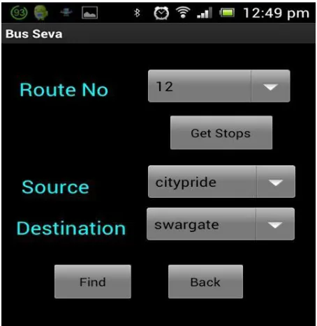
The real time tracking system has developed an android application that allows the user to send their request to the system server for the bus details. On receiving the request the system has to first find the user intended buses, and calculate the distance for each one of them. Upon proper calculation the server sends the proper response to the user containing the list of available buses to him and their arrival time for each one of them. Based upon the user schedule convenience the user selects the bus and for more reliability and user convenience the android application is also sending with a Google map locator variable that shows the location of the selected bus out of the available bus on the Google map.
The android application is provided with the two tabs:
First one showing the list of available buses for the user enquiry.
Second showing the Google mapping location of the opted bus by the user.
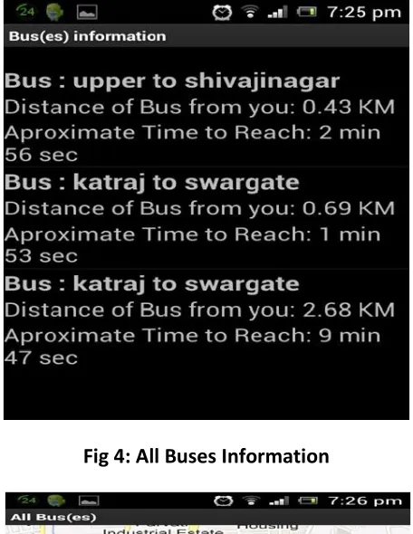
Available Online at www.ijpret.com 1813 Fig 4: All Buses Information
Fig 5: Bus Location on Google Map
Text Messaging Capabilities
Available Online at www.ijpret.com 1814
User has to simply text source and destination location to sever to receive the current bus location. Upon receiving the enquiry SMS the system has to first match the query parameters. After calculating estimated time it will respond to user through SMS.
CONCLUSION
With Real Time Tracking System using GPS the management of time get ease to a great extent. The implementation exceeds the various requirement in many ways like real time positioning for user requirement, providing dynamic updates to all the user, providing Static in addition. Also the aspects like ease of user convenience is also given priority while developing the entire system.
The important points highlighted in the system is consideration given to aspects like official working hour, specific week day, special festival occasion while calculating the traffic aspects.
More appropriate data results can be formed with the increase in the number of segments of the routes. This helps in deriving more precise result for estimation of bus arrival time.
The commuters becomes capable to decide their schedule and manage accordingly to leave from their work space or homes for the travel. This paper had kept forward a project that can help to improve the transportation system to get convert into an intelligent transportation system. Not only to the bus but the same system can help a lot in managing the delivery system by extending the project.
ACKNOWLEDGMENTS
We would like to express gratitude towards our teachers, who immensely helped us, especially Prof. S. B. Patil, who gave us the opportunity to learn under her wisdom, and our HOD Prof. Sachin Sakhare, who inspired us through example. We also thank everyone from industry and academia who appreciated and contributed to the concept of Real Time Tracking System using GPS. We are also grateful to our friends to have always stood by us for implementing the idea. Thank You!.
REFERENCES
1. Fu, L., and X. Yang. “Design Implementation of Bus-Holding Control Strategies with Real-Time
Available Online at www.ijpret.com 1815
2. Ehsan Mazloumi, Graham Currie, Geoff Rose, and Majid Sarvi. Using SCATS data to predict
bus travel time. Institute of Transport Studies, Monash University, Melbourne, Australia
3. Jason Dudley, Ron Vetter, Jeff Brown, Tom Janicki. Building a Real-Time Bus Tracking Data
Display System. UNC Wilmington, North Carolina 28403 USA.
4. Jerald Jariyasunant, Eric Mai, Raja Sengupta. Algorithm for finding optimal paths in a public
transit network with real-time data. Department of Civil Engineering, University of California, Berkeley.
5. Dihua Sun, Hong Luo, Liping Fu, Weining Liu, Xiaoyong Liao, and Min Zhao. Predicting Bus
Arrival Time on the Basis of Global Positioning System Date.
6. James Biagioni, Tomas Gerlich, Timothy Merrifield, Jakob Eriksson. Easy Tracker: Automatic
Transit Tracking, Mapping, and Arrival Time Prediction Using Smartphones. Department of Computer Science, University of Illinois at Chicago, Chicago, IL 60607, USA.
7. Schweiger, C. L. TCRP Synthesis 48: “Real-Time Bus Arrival InformationSystems: A Synthesis
of Transit Practice. Transportation Research”.
8. Mr.Y.Ramakrishna,Mr.P.Ramakrishna,Dr.R.Sivanandan,Mr. V.Lakshmanan.System: Bus Travel
Time Prediction Using GPS Data.
9. Hong-En LIN, rococo ZITO,A Review of Travel-Time Prediction in Transport and
Logistics.Record: Proceedings of the Eastern Asia Society for Transportation Studies, Vol. 5, pp. 1433 - 1448, (2005).