EXECUTION OF DOCUMENTATION FOR REGISTRATION IN THE LAND
REGISTRY OF A PROPERTY WITH RAILWAYS USE CATEGORY
Miluț Marius, Călina Jenica, Croitoru Alin
University of Craiova, Faculty of Agronomy [email protected]
Keywords: cadastral documentation, way of use, railway
ABSTRACT
This paper briefly discusses the documentation for registration in the land register of immovable property with category of use railways. To achieve measurements and topo-cadastral documentation was used both equipment and programs until recently considered at latest generation, with high productivity and accuracy.
As surveying methods were used the traverse supported at the ends on points with known coordinates and polar coordinates method for details location.
INTRODUCTION
According to the order 700/2014 of the ANCPI Director, cadastral documentation is all technicaldocuments, legal and administrative necessary to registration at demand in the integrated land registry of properties, stating the real situation on the ground.
Preparation of cadastral documentation, reception and registration in the land register on integrated stream of cadastre and land registry involves several steps: identify the location of property by the owner, indicating its boundaries by the person authorized and technical documentation; execution measurements; cadastral documentation; registration request to the territorial office of cadastre; reception of cadastral documentation; entry in the land register of real rights over the property (Ord.700/2014).
MATERIAL AND METHOD
The aim of the work was the preparation of documentation for registration in the land registry of the property located in Craiova, Station CF Craiova, Line 901 Km CF 246 + 997 - Km CF 248 + 782, left side, line 900 Km CF 205 + 900 - Km CF 207+720, left side 912 railway line Km CF 250 + 060 - Km CF 251 + 862 CF, right side, Dolj County, at the request of the owner.The object of the work was the property at the address mentioned above - Craiova railway station – public domain.
To achieve topographic measurements were used both GNSS technology - Leica GS09 and total station Leica TCR 403. To determine the coordinates of the points required for the location and boundary plan was used supported traverse at the ends on points with known coordinates for the surveying networking and polar coordinates method for measuring the details of the surface studied.
DISCUSSIONS
Because property subject to documentation is bordered by several buildings entered in the integrated cadastre and land registry, was sought from Dolj OCPI information on the documentation submitted prior, to verify determined points on their common boundary.Mentioned that the limit on the perimeter of property belonging to the Romanian State -M.T.I. administrator, Railway Company "CFR" SA concessionaire, was taken from the branch cadastre service "REGIONAL CENTRE OPERATIONS, MAINTENANCE AND REPAIR RAILWAIS " CRAIOVA.
Were checked cadastral documentation recorded at OCPI Dolj with numbers: 21512/2012, 22291/2007, 75008/2007, 52184/2008, 12573/2007, 54520/2008 and their limits received were taken to avoid creating overlaps.
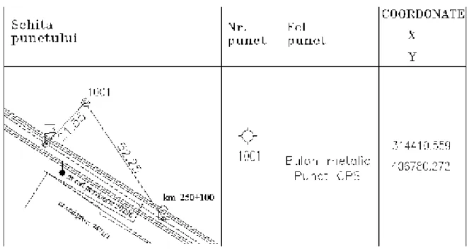
For integrating the work in Stereographic projection system 1970, initially was done thickening network using Leica GNSS GS 09, in static mode. Were determined GPS points B1 (1001), B2 (1002), B3 (1003), S5 (2005), B4 (1004) and B5 (1005).
Points determined by GPS technology were marked on the ground by metal bolts, achieving their topographical description.
Figure 1. Topographical description of B1 (1001)
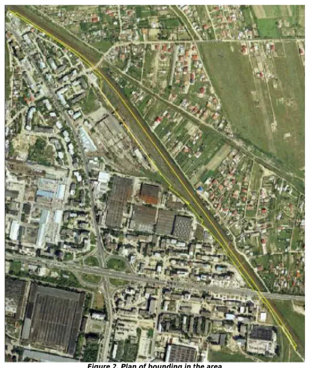
Figure 2. Plan of bounding in the area
For points of detail was applied polar coordinates method. From stations1001, 2002, 2003, 2004 and 2005 were targeted all points of detail required for the documentation of registration in the land register, on the device were registered the horizontal directions, distances and vertical angles.The sketch of traverse is shown in figure 3.
Step office started downloading data stored from the internal memory of total station on a PC, where they were processed using Toposys.
It started from the previously determined coordinates with GPS technology:
Figure3. The sketch of traverse
The following table presents coordinates of stations from which was done mesurement of detail points:
Point no. X Y
1001 314410,559 406780,272
2001 314161,657 407130,213
2002 313939,027 407280,217
2003 313724,401 407441,131
2004 313437,117 407647,412
2005 313116,883 407882,202
normative in force and Methodology introducing real estate survey in the localities and the law 7/1996, of Cadastre and land registration.
From absolute coordinates of the contour points have been calculated the total area of the property and of the 7 existing buildings inside it.
Also at office stage, in completion of documentation was prepared Technical Memorandum and Data Sheetof the property.
Based on the documentation prepared was requested for entry in the land registry the property under study.
CONCLUSIONS
Current needs of society and the exponential growth of computing imposed an increase in the speed of obtaining results in the field of cadastre.
This paper briefly discusses the documentation for registration in the land register of a immovable property with category use railways. To achieve measurements and topo-cadastral documentation was used both equipment and programs until recently considered at latest generation, high productivity and accuracy.
The property which is the subject of documentation is found on the territory of Craiova, is part of the public domain and is administered by the Ministry of Transport and having as concessionaire the National Railway Company "CFR" SA.
The resulting surface of measurements was 45571 s.m. and based on the prepared documentation requested for entry in the land registry.
BIBLIOGRAPHY
1. Călina A., Călina Jenica, Croitoru A.,Study on Building of Planimetric Network Stakeout for a Commercial Space Using Combined Technology GPS-Total Station, Conference Agriculture for Life, Life for Agriculture, Vol. 6, USAMV Bucharest, pages 127-135, 2015.
2.Călina A. and colab.,Topografie generală şi inginerească, Editura Sitech, Craiova, ISBN 973-657-945-X,2010;
3.Călina Jenica, Călina A., Miluț M., Băbucă N.-Surveying data processing for extension, land registration and construction improvement, Annals of the University of Craiova - Agriculture, Montanology, Cadastre Series, pag. 47- 57, Vol. XLIV/2 2014;
4.CălinaJenica, Călina A., Băbucă N., Study on the implementation of GIS databases in achieving the general urban plan, International Scientific GeoConferences SGEM VOL. 1, Ed. STEF92 Technology, Ltd. Sofia, Bulgaria, pages 817-824, 2014.
5.Miluț M., CălinaJenica, Călina A., CroitoruAlin, 2014, Elaborating documentations for changing the category of use to construct a field of photovoltaic panels, Annals of the University of Craiova - Agriculture, Montanology, Cadastre Series, pag. 127-131, Vol. XLIV/2 2014;
6. Păunescu Cornel, Mocanu Victor, DimitriuSorin G.,Sistemul de determinare a pozițieiutilizândsateliți, EdituraUniversității din București, 2011;