NUMERICAL MODELLING STUDY FOR APPLICATION OF HYDRAULIC
STRUCTURES FOR FLOOD CONTROL
SYAHRULNIZAM @ HELMI BIN MD SUKIMIN
A project report submitted in partial fulfilment of
the requirements for the award of the degree of
Master of Engineering (Civil – Hydraulics and Hydrology)
Faculty of Civil Engineering
Universiti Teknologi Malaysia
TO:
MY FAMILY
&
EMILIA
ACKNOWLEDEMENTS
It is great pleasure to address those people who helped me throughout this project to enhance my knowledge and practical skills especially in research area. My deepest and most heartfelt gratitude goes to my supervisor, Assoc. Prof. Dr. Norhan bin Abd. Rahman and En. Kamarulazlan bin Mohd. Nasir. The continuous guidance and support from both of them have enabled me to approach work positively.
My gratitude also been extended to all personnel of the Laboratory of
Hydraulics and to all staff especially in the Department of Hydraulics and Hydrology for their support, cooperation and constructive criticisms during the research period.
Many thanks to Universiti Teknologi Malaysia and generally to Malaysia Government for giving me chance to pursue my study. Also thanks to Adib, Mohd. Kamarul Huda, Mohd. Amzari, Hood Tendot, Norasman, Zulkifli, Hakim, Juwita, Liew Kuet Fah and other classmates for their helped and support.
ABSTRACT
Mathematical models have been developed to resolve many problems that are related to water profile evaluation.The flow through weir can be solved using
numerical methods and computer techniques. Storage in channel and river could be utilized by installing weir at strategic locations along the river. This approach might be benefited in flood control to the downstream area, but it could also cause flooding in the upstream due to the backwater effect. The problem is whether by the
installation of those weirs will produce backwater at the upstream area. By using numerical equation the effective application of hydraulic structures such as weir can be determined. The computer program such as FEWMS Fst2dh is numerical program has ability to simulate the flow in structure hydraulics. The effectiveness of weirs at the upstream Sungai Plentong can be determined by using FESWMS Fst2dh
modelling that is enable Surface Water Modelling System (SMS) software. The simulated water surface elevation will be used to identify which areas that are have problem with backwater. The result observed data shows that the existing weir in the channel at the upstream of Sungai Plentong can reduce to 80% of the channel water depth. The simulated of water level results shows that the weir did not producing significant increase effect of water level due a backwater.
ABSTRAK
INTRODUCTION
1.1 INTRODUCTION
Mathematical models have been developed to resolve many problems for water profile evaluation. A mathematical model consists of a set of differential equations that are known to govern the flow of surface water. Usually, the assumptions necessary to solve a mathematical model analytical are fairly restrictive. To deal with more realistic situations, it is usually necessary to solve the mathematical model approximately using numerical technique.
Rivers are valuable natural resources for human life, environment and national development. There are 150 river systems in this country with 100 of them in the Peninsula Malaysia and 50 in Sabah & Sarawak. These river systems consist of 1800 rivers with a total length of 38,000 km. River conservancy is one of the responsibility of DID since its inception in the year 1932. After the 1971 major flood in the country, DID was given the task to carry out flood mitigation programs. One of the challenge of this department is problem of many river at downstream in this country is not capable to cater the flow. So, one of the solution for this problem is to construct hydraulic structures to control the flow in river channel.
1.2 PROBLEM STATEMENT
For most of this century, open-channel flow and other hydraulic calculation is based on 1-D flow approximations. Although 1-D solutions provide accurate analysis of many problems, the assumptions upon which are based is often strained, therefore the reliability of the solution is compromised. However, 2-D approximation of flow in a horizontal plane often yields solutions of sufficient detail for highly complex hydrodynamic problems. Two dimensional depth average flow solutions have been found to provide excellent descriptions of flow in open channels and flood plains where topography has created unusual flow pattern that are difficult to evaluate using 1D flow approximations such as flow at hydraulic structures.
1.4 OBJECTIVES OF THE STUDY
The objectives of the study are as follows:
a) To study an effectiveness of hydraulic structures for flood quantity control. b) To evaluate flow characteristics for weir and orifices system in open channel.
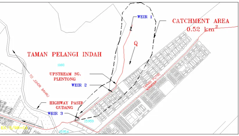
orifices system. The study will concentrate on one weir at the downstream area. The weir was constructed in 2001. All three weirs were constructed in same channel (see Figure 1.3). The catchment area involved is about 0.52 km2. The size of existing monsoon drain is 11 m width and 3.3 m heights (see Figure 1.4). The maximum flow capacity for this channel is 240 m3/s and the estimate flow rate base on 100 years ARI from catchments area is about 23.4 m3/s.
b) The software used to simulate surface water profile is FESWMS Fst2dh (numerical model for hydraulic structures) integrated in Surface Water Modelling System (SMS).
c) Field Work- involved data collection such as flow rate, river water level, river condition and topography
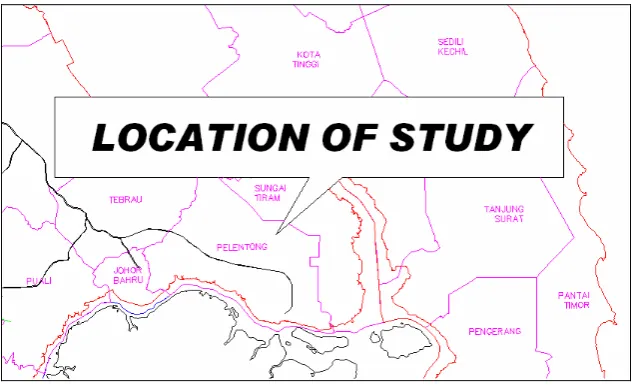
Figure 1.2: Location of Site Area at Upstream Sungai Plentong