GIS AND DECISION SUPPORT SYSTEMS FOR MALAYSIAN DEVELOPMENT PLAN STUDIES
Ahris Yaakup, Foziah Johar, Mohd Anuar Maidin, Ezrein Faizal Ahmad Department of Urban and Regional Planning
Faculty of Built Environment Universiti Teknologi Malaysia
Email: [email protected]
Abstract
The Malaysian development planning system was refined in line with the amendment of the Town and Country Planning Act, 1976 (Act 172) in year 2001. The amended Act plays a major role in the reform of the development planning system in the sense that it insists the incorporation of the Geographical Information System (GIS) into the development plan preparation process at all planning hierarchy, be it the macro or micro level. Apparently, the preparation of development plans calls for a continuous and cyclical planning process comprising the identification of needs and goals, formulation and evaluation of alternatives as well as monitoring the implementation of the plans. GIS is claimed to be an effective tool in providing analytical and quantitative methods for urban and regional planning analysis, and thus offer a strong platform for decision-making in its role as the major component of Decision Support Systems (DSS). Currently, the adoption of Multi Criteria Decision-Making (MCDM) technique and use of DSS such as What if?, Definite and ILWIS while utilising the GIS spatial analysis capabilities have been among the new approach in the formulation of the spatial development strategies. This paper will focus on the application of GIS for the development plan formulation and implementation at both the state (macro) and district (micro) levels based on case studies of the Pahang State Structure Plan, Application of GIS for Klang Valley (AGISwlk) and the Pekan District Local Plan. Beginning from the philosophy and conceptual aspects of the application of GIS for development planning, this paper will briefly discuss the preparation of GIS for the purpose of the development plans formulation and implementation. This paper will also emphasize on the application of the MCDM technique in the formulation of strategies and policies at the state level through generation of development scenario alternatives, as well as location-allocation at the district level. Finally, the paper discusses the challenges and prospects of GIS/DSS for development plan studies.
INTRODUCTION
Planning methodology has changed over the years as emphasis has shifted from producing plan, which described a state of affair expected of some future date to one, which acknowledged the continuous and cyclical nature of planning. The task however, should involved the identification of needs and goals, the formulation and evaluation of alternative courses of action and monitoring of adopted programmes (Yaakup, 2004). In planning field, the advent of Geographical Information Systems (GIS) has significantly changed both its substantial and procedural components. GIS technology has been used for development plan preparation in different spatial scales as well as for the both macro and micro level of planning. This paper sets out the information requirement and GIS functionalities, which are relevant to the various plans. This paper also demonstrates the various level of GIS application and techniques, based on the National Physical Plan, the State Structure Plan and the GIS application for the District Local Plan. Some applications have a well-integrated and comprehensive database which support the Spatial Decision Support Systems (SDSS) application in plan making process. The paper will also discuss various modelling and spatial analysis techniques appropriate for different stages and form of planning which integrate GIS and other PSS for plan generation and plan evaluation technique such as ‘What-if’ and Spatial Multi-Criteria Evaluation (SMCE). Finally the paper discusses the various issues involved in developing the various levels of GIS which include data availability and reliability, human resource and continuous application of GIS in development plans.
INFORMATION SYSTEM AND SPATIAL PLANNING
The idea of urban and regional planning in Malaysia is said to have originated from the planning concept first introduced in Britain, whereby planning is defined as ‘ a process of human forethought and action based upon that forethought. It aims at the best use of land and greatest possible ‘improvement in the human environment’ (Chadwick, 1971). This definition sees general planning as a procedure in which suitable schemes are designed at the outset and actions are based on the chosen schemes. Physical planning, on the other hand, is seen as referring to the ‘physical design or plan of some artefacts or building which might exist in the future’ (Bruton and Nicolson, 1987).
viewed as “communication” suggests an interactive, open and ongoing process of intersubjective communication and and collective design aimed at common consensus building (Healey, 1992).
These evolving discourses have been accompanied by fundamental although interdependent changes in the prevailing views of proper information system in public and private sector organisations. Klosterman (2001) has succinctly provides the evolving concerns of information technology (Table 1). In 1960’s was in data handling in which the prevailing technology was batch processing of custom design, single-purpose, and transaction based information systems on mainframe computers. In the 1970’s, the emphasis changed from data conversion into meaningful form or information. Consequently data processing for operational needs shifted to Management Information Systems (MIS). MIS began to be integrated with the development of Urban Information System (UIS), Geographical Information Systems (GIS) and Land Information System (LIS). The next decade saw the shift of information into knowledge. The needs of decision makers’ desire for analytical modelling capabilities are more than what MIS can offer. The 1990s saw a number of intelligence-based information technology projects. The Planning Support System (PSS) will provide intelligence in handling novel problems and to use experience and knowledge to guide behaviour, and designed to facilitate collective design, social interaction, interpersonal communication, and a community debate (Klosterman, 2001).
Table 1 : The Evolving Concerns of Information Technology
1960s Data ‘Observations which have been cleaned, coded and stored in machine-readable form’
Primary concern of electronic data processing (EDP) which promoted efficient transaction processing to improve operational tasks
1970s Information ‘Data which has been organised, analysed and summarised into a meaningful form’
Primary data concern of management information system (MIS), which integrate diverse data sets to serve management needs. 1980s Knowledge ‘Understandings based on information, experience and study’
Primary concern of decision support systems (DSS), which facilitated semi-structured decision-making to support executive decision making.
1990s Intelligence ‘Ability to deal with novel situations and new problems, to apply knowledge acquired from experience, and use the power of reasoning effectively as a guide to behaviour’
Possible concern of planning support system (PSS), which will promote discourse and interaction to facilitate collective design.
Source : Brail and Klosterman (eds), 2001. Planning Support Systems: Integrating Geographic Information System, Models and Visualization Tools. ESRI Press, California.
thus providing up-to-date information (Grimshaw, 1988; Coulson and Bromley, 1990). However, GIS alone cannot serve all the needs of planning because the current generation of “general purpose” systems cannot easily accommodate the particular informational, computational, and display needs of planning. However, planning requires (i) information that is effectively “a spatial” at a particular level of analysis; (ii) information over time; and (iii) measures of spatial interaction. None of this can be easily incorporated into standard GIS packages (Harris and Batty, 1993).
Thus, planners will have to adapt existing GIS tools to meet their needs. Traditional programming languages can be used to developed spatial analysis and modelling tools entirely independent of commercial packages. A combination of sophisticated GIS macro commands and traditional programming language also can be used to developed analytical models closely linked to full-featured GIS toolkits (Klosterman, 2001). The inevitable evolvement of IT towards PSS means that the employment of GIS is more significant. The GIS will serve first as a display and communicative device, producing maps and charts that describe past and present conditions and model outputs that suggest alternative futures. However, its spatial analysis capabilities can be used to generate new spatially referenced information required by the computational components of the system.
Planners should also make full use of traditional tools for urban and regional. A PSS therefore must combine these tools with other technologies such as expert system (Han and Kim, 1989), decision support aids such as multi-attribute utility theory (Lee and Hopkins, 1995), hyper media systems (Shiffer, 1992), and group decision support systems (Armstrong, 1993; Finaly and Marples, 1992).
GIS/DSS FOR DEVELOPMENT PLAN SYSTEM IN MALAYSIA
Development planning requires an effective planning approach to achieve the desired goals and objectives, evaluate alternative as well as control development programs that are in line with the current and future prospects.
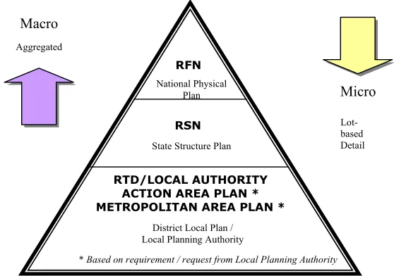
Development Plan System in Malaysia
Figure 1: Hierarchical framework of development plan system. (Source: FDTCP, 2003)
The various plans include:
• The National Physical Plan (RFN), which outlines the strategic policies for the purpose of determining the general direction and trend of the nation physical development.
• The Regional Plan, which establishes policies to guide and coordinate development for a region especially in the provision of infrastructure and facilities within the region.
• The State Structure Plan (RSN), which sets out the policies and proposals for the development and use of the land in a state.
• The District Local Plan (RTD), which translates the state policies at local level.
This is indeed parallel to the idealized framework of strategic planning suggested by Bruton and Nicolson (1987). Thus, planning in Malaysia is guided by the National Physical Plan at the highest level. The strategic policies which set out the national physical trend of development will be translated at the State Structure Plan. The control of development at the local level is tied to the District Local Plan which is the detailed land use plan that incorporates the national as well as the state development policy. The following discussion will look at the scope of GIS at each of these levels.
GIS AND DSS APPLICATION FOR DEVELOPMENT PLANNING
Development planning requires an effective planning approach to achieve the desired goals and objectives, evaluate alternative as well as control development programmes that are in line with the current and future prospects. GIS technology has long been applied in planning activities which essentially include plans formulation as well as development control (Johar et al., 2003). The Manual published by the Federal Town and Country Planning Department for preparing the various levels of plan has provided that all plans use GIS technology in plan formulation. The different spatial level and form of plans requires different support in term of information system. Various skills are also required for preparing development plans using GIS. They
National Physical Plan
RFN
RSN
RTD/LOCAL AUTHORITY ACTION AREA PLAN * METROPOLITAN AREA PLAN * Macro
Micro
State Structure Plan
District Local Plan / Local Planning Authority
Lot-based Detail Aggregated
include the ability to build up and manage the database which should incorporate socio-economic attributes of the local population. Managing services at local level would also call for contiguity and proximity analysis. Cartographic skills are of importance if plans are to be exhibited.
The National Physical Plan
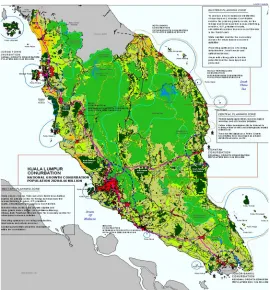
The National Physical Plan outlines the strategic policies for the purpose of determining the general directions and trends of the nation physical development. At national level, GIS is used mainly for data compilation, land suitability analysis and generate suitability maps (Yaakup, 2001).
Several study objectives were addressed for achieving the aims of providing comprehensive database and management system manual for spatial planning, providing indicative maps, providing policies and planning strategies for national spatial development as well as providing public institutional structure responsible for management, implementation and monitoring of the RFN. The study approach for the RFN provides for cyclic and continuous feedback on data compilation, analyses and strategies from the relevant agencies/departments. The RFN study will only focus on major and significant factors determining the level of suitability of areas for future urban development at a macro level. Thus, further detailed criteria would need to be looked into at other levels of planning such as the state and local level studies.
At the national level, the plan essentially requires information of broad land use. It uses GIS to determine land availability according to various criteria taking into account major factors such as existing urban areas, areas with physical constraints, agricultural areas to be preserved and so forth. Objective for carrying out the land availability analysis is to identify land which would be available for future urban development based on the two objectives of maximizing existing resources/investment and the preservation of the natural environment and national assets. The land availability analysis is carried out based on the sieve map technique. Criteria for identification of land available for development include existing urban areas, areas with physical constraints, as well as agricultural, water catchments, proposed dams and environmentally sensitive areas to be preserved.
Figure 2: National Physical Plan: Alternative Development Plan Strategy (Source: Technical Report of National Physical Plan, FDTCP, 2003)
GIS for the RFN should also be able to generate economic growth and job projection. This can be used to analyse the relationship between population and job created in the region. Such analysis becomes important in projecting future requirement for housing, commercial floor space, school, recreational facilities etc. The analysis can also forecast the future economic linkages, manpower demand and supply. The GIS should support certain economic analysis such as location quotient, minimum requirement techniques, shift-share, economic-based analysis and industrial linkages. Ideally, economic-based model and industrial growth can explain the economic growth for specific cities or regions. This can be used in making future economic decision (Yaakup, 2001). In the context of accessibility and transportation aspect, the transportation models such as trip generation, travel pattern, gravity model and travel mode were useful in transportation network planning either for inter-region or intra-region connectivity. Transportation planning often involves an existing assessment related to mobility demand and the question on how to fulfil the demands.
The Regional Plan
Example of GIS application at this level is the Application of GIS for Klang Valley Region (AGISwlk), which was meant as a planning support system for decision makers in planning and monitoring of the region. GIS is identified as the main tool in the formulation of this regional plan. Its functionalities are widely used to generate current and future development scenarios, which further facilitate among others, in determining future trend of infrastructure investments. Introduction of GIS for regional analysis has improved the decision-making process by improving data accuracy and accessibility and as a consequence leads to ‘better’ decision. The information at this level helps to describe the existing situation. It also contribute to improve understanding of regional problems by providing key factors and variables that can be analysed using regional modeling and other spatial modeling techniques. Design of the regional information system is based on an understanding of how the regional authority operates and how planning is carried out. Regional authority functions or task, and the types of data, which support them, comprise the vital elements involved in planning and monitoring urban development in Klang Valley region. The tasks and supporting data provide the fundamental framework upon which a conceptual model of geographic data entity and their relationship is developed. In Klang Valley region, monitoring urban development and its land use change forms an integral part of the process whereby policies and strategic plans are reviewed and updated. This task typically involves the identification of emerging land use patterns, which are normally linked with other planning statistics such as employment, housing and population before the full significance of land use changes is discernible.
The main challenge in planning and monitoring of an urban region like Klang Valley is the rapid growth of the region itself, resulting in the urgent needs for land development to cater for settlement/housing and facilities. Among the myriad of urbanisation issues faced by the local authorities in Klang Valley regions includes traffic congestion, provision of houses and amenities and declining environmental situation. With rational planning approach, the quality of planning and decision making process can be substantially improved with valid data appropriately and efficiently handled.
A well integrated and comprehensive GIS database have been designed and developed regionally to support ten main application modules namely built up area, green and recreational area, traffic and urban transportation, squatter and low cost housing, environment, utilities and community services, industrial and commercial development, population and socio-economic, geohazard and tourism. In order to achieve the requirement of these database development, ten elements of data have been prepared including base map, administrative boundary, physical characteristics, land development, population and socio-economic, environmental quality, traffic and urban transportation, green and recreational areas, public facilities and utilities.
boundaries) and data-to-function relationships (i.e. data which are not coincident but tend to be used by more than one user has to be included in the same map layer). These factors were recognised to ensure that consistency is maintained and the capture of data is minimum.
Integrated Land Use Assessment: The Use of What-if? Planning Support System
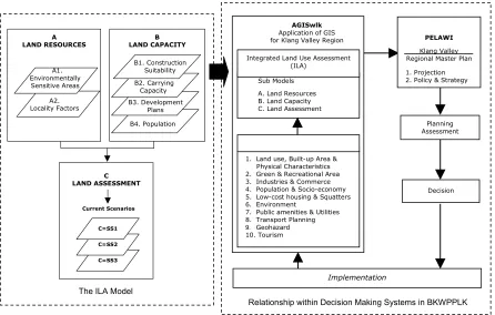
Evaluation is an essential step in the planning process especially in selecting the appropriate development scenario alternative to be implemented. As such, it is necessary for decision-makers to define the suitable planning evaluation model so that the development scenario chosen could cater for future planning and its implementation is beneficial to the public. Since AGISwlk has established an extensive database, an evaluation model was then developed.An Integrated Land Use Assessment (ILA) is a new concept recently introduced within AGISwlk, aimed at developing an integrated spatial analysis model with the ability to generate alternative development scenarios by integrating physical and socioeconomic information. The concept of integrated approach in ILA is focused on the aspect of integration of the applications previously developed in AGISwlk, which are inclined towards sector-based. The introduction of ILA as an integrated land use planning approach that applies the GIS analysis capabilities while supported by the use of planning support system (What if?) is seen as a good alternative for achieving better and more rational decisions. The developed model is expected to dynamically support the preparation of the Klang Valley Regional Master Plan (PELAWI). Figure 3 shows the developed and implemented model for integrated land use assessment of Klang Valley. ILA is also expected to accomodate the main tasks of the Federal Territory Development and Klang Valley Planning Division (BKWPPLK) which are regional planning, facility management as well as problem solving.
C LAND ASSESSMENT C=SS3 C=SS2 C=SS1 Current Scenarios A LAND RESOURCES A1. Environmentally Sensitive Areas A2. Locality Factors B LAND CAPACITY B1. Construction Suitability B2. Carrying Capacity B3. Development Plans B4. Population
The ILA Model
Figure 3: The model developed and implemented for Integrated Land Use Assessment of Klang Valley
Relationship within Decision Making Systems in BKWPPLK
Implementation
Sub Models
A. Land Resources B. Land Capacity C. Land Assessment Integrated Land Use Assessment
(ILA)
1. Land use, Built-up Area & Physical Characteristics 2. Green & Recreational Area 3. Industries & Commerce 4. Population & Socio-economy 5. Low-cost housing & Squatters 6. Environment
7. Public amenities & Utilities 8. Transport Planning
9. Geohazard 10. Tourism
AGISwlk
Application of GIS for Klang Valley Region
Planning Assessment
Decision
PELAWI
Klang Valley Regional Master Plan
`
Figure 4 : Integrated Land Use Assessment Development Options
The ILA Model is dynamic in approach, providing flexibility for users in manipulating the selection criteria and organising them on priority basis for the development of the scenarios (Figure 4). The assessment technique in ILA adopts the GIS spatial analysis technique combined with the weighting and sequential techniques. ILA involves two type of assessment namely Land Resources Assessment and Land Capacity Assessment. Land Resource Assessment aims at evaluating potential land resources for development in terms of suitability by considering two deriving factors, which are Environmental Sensitive Areas and Highly Accessible Area base on locality factors. The Land Capacity Assessment evaluates the extent of acceptable development in terms of supply to ensure that the environmental quality is not degraded. The Land Capacity Assessment involves four deriving factors including Construction Suitability (Terrain Map), Carrying Capacity for River Basin, Transportation as well as Public Facilities, Development Plan and Population Carrying Capacity.
The implementation of ILA model was divided into three main stages. The methodology was developed and organised based on the GIS spatial analysis process and planning support system framework. The first stage involves identifying of policy and strategy to be used as guideline and direction of study in achieving the desire output. The second stage involves identifying data in AGISwlk database to be used to create Uniform Analysis Zone (UAZ) based on predetermined selection factors. UAZs are GIS generated polygons, which are homogeneous in all respects considered in the model (Klosterman, 2001). The analysis and modelling stage involves the process of creating UAZ, designing project file and conducting suitability analysis. The process of creating UAZ layer includes combining of GIS data layers. The GIS functions involved in the process are the overlay function, classification and measurement. Designing the project file is most important because it influences the suitability analysis and affects the resulting output. The suitability analysis involves three steps which are selecting the suitability factors, specifying factor weights and
specifying factors ratings. In this study, a mathematical formula was applied for all factors in generating the development scenarios.
The State Structure Plan: A Case Study of Pahang State Structure Plan
Part III of the Act 172 (Ammendment 2001) stated that the State Structure Plan (RSN) is a written statement of the policies and general proposal of the State Planning Committee regarding the development and use of land for the state (FDTCP, 2001a). According to the RSN Manual, the preparation of RSN is crucial for the planning authority to initiate inspection on the state development when required by the State Planning Committee or if changes in the sectoral policies occur, which will consequently affect the trend and pattern in the state development.
The inspection and reevaluation process involve enormous collection of data to be analysed for the purpose of formulating policies, strategies and key diagram, which determine the direction of the state development. The state level GIS should provide a comprehensive database of spatial information which include land use, utilities, environmental quality, agricultural land, etc. The role of GIS is made explicit in the design and development of a system for spatial as well as attribute data entry, storing, updating, analysis and presentation. The choice of GIS as a planning support tool is mainly to assist in the preparation of the key diagram that is highly reliable and rational. GIS capabilities in handling spatial analysis will be used to identify potential area for future development taking into account socio-economic, environmental as well as physical factors.
The GIS has proven to be an invaluable tool for evaluating alternative solution to state structure planning problems. State based GIS can be extensively interrogated to generate several alternative solutions to state strategic planning problems. Various scenarios which take into account the socio-economic characteristics of urban and rural dwellers, the constraint of physical development, availability of land and land suitable for different kind of development can be generated. From the state structure plan project, it can be seen that GIS bring rationality to the decision-making process. Since the geographic informations stored and processed in its primary form, analysis can be quantitative and rational in nature. The modelling stage, for example, requires planners to make explicit the criteria for the selection of alternative development strategy. This encourages the selection of objective criteria, based on real data about the area under study.
Using MCDM to generate State Structure Plan Development Scenarios
The MCDM method incorporates two different techniques, i.e using What if?
software to generate spatial scenarios and Definite software for defining the weight and rating as well as evaluation of the resulting scenarios. In this approach, the state development strategies and objectives are each given a weightage and rating. Each of the objectives is further refined into criteria. The criteria are identified based on their relationship with the relevant objectives and their ability to influence the achievement of the objectives. The criteria are further classified into sub-criteria based on the relevant planning guidelines, standards and manual (Appendix I and Appendix II). Each criterion is assigned the relevant weightage and rating formulated by the multi-sectoral study team who each acts as the stakeholder of the respective sector. Specific criteria are used to determine rating and ranking for each class and sub-criteria’s in every criteria. The suitability of each criteria is used to differentiate the development objective. The Pairwise Comparison is also used to provide the weightage and rating value among criteria (Appendix III and Appendix IV). In this method, weightage is given to show the priority of criteria. Definite 2.0 software is used to calculate the weightage and rating value. Using different weightage and rating, alternative development scenarios can be generated. Figure 5 shows two alternative scenarios of development strategies with different emphasis, i.e. development and conservation. Map generation includes two main steps; i) assigning weightage value: and, ii) assigning the rating into What-if? programme to produce suitability maps for each scenario (Figure 6).
Figure 5: The Resulting Development and Conservation Scenarios
(Source: Interim Report, Pahang State Structure Plan, 2003)
Figure 6: The Resulting Suitability Map generated using What-if? programme
(Source: Interim Report, Pahang State Structure Plan, 2003) DEVELOPMENT
SCENARIO
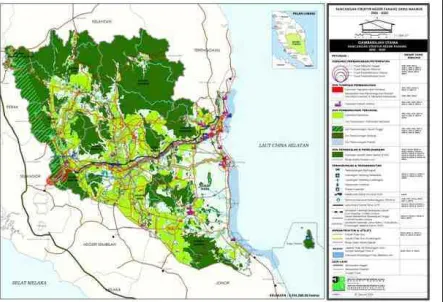
Thus, the determination of various development alternatives involve enormous collection of data to be analysed for the purpose of formulating policies, strategies and key diagram, which determine the direction of the state development. The preparation of the key diagram involves a combination of analyses such as determination of area having potential for future development and area for conservation (Figure 7).
Figure 7: Key Diagram of Pahang State Structure Plan
(Source: Interim Report, Pahang State Structure Plan, 2003)
The District Local Plan : A Case Study of Pekan District Local Plan
At the local government level, the district local plans are statutory document that become the basis of development guidelines and control. These plans contain such details as land use zoning, development density, building height, plot ratio, etc. which require detailed information of each plot of land to be formulated. The tasks of preparing and analyzing this information can be speeded up and made easy with the help of GIS. In the District Local Plan (RTD) preparation, GIS became one of the sectoral packages as mentioned in RTD Manual (FDTCP, 2001b). A well-integrated and comprehensive database is designed to meet the local authority’s requirement. At this level, spatial analysis involve determination of land suitability, combining the technique of multi-criteria evaluation.
Figure 8: Zoning Plan for Pekan District Local Plan
(Source: Technical Report, Pekan District Local Plan, 2003)
Past study has shown the effectiveness of MCDM in generating various land use development suitability alternative plans (Mohd Anuar, et.al, 2004). MCDM was carried out for the town centre of Pekan Royal Town, which faced issues including unplanned housing development, lack of industrial infrastructure and unsystematic agricultural development. Using the method shown below (Figure 9), various land use suitability maps are generated namely for housing, agriculture and industry allocation (Figure 10).
Figure 9: Selection of the Criteria Model Aims and Objectives
Data Availability
Determination of Objectives Analyze the Problems Industry and Commercial
Formulation of Criteria and Scoring
Selection of Appropriate Analysis Model
Multi-criteria Analysis
Pekan District Local Plan GIS Database
Land Suitability For Housing
Land Suitability For Industry Land Suitability For
Industry & Commercial
Land Suitability For Development
Scenario 3 Scenario 2
Scenario 1
Selection
Agriculture Housing
Multi-criteria Evaluation
Development Constrain Area Analysis Vision and Development
Figure 10: Land Suitability Analysis For Industrial Use
Figure 12: Land Use Allocation Scenarios
The study also developed a Multi-Criteria Evaluation to choose appropriate scenarios for for development using various criteria. (Mohd Anuar, et.al,
2004) (Figure 13 & Figure 14).
Step 1 Starting DEFINITE
Identifying the Problems
Determination of Score Value Step 2
Determination of Criteria
Multi-Criteria Analysis
Determination of Weightage Factor Step 3
Formulation of Weightage Factor for Each Criteria
Sensitivity Analysis For Multi-Criteria Evaluation
Sensitivity Analysis
Formulation of Weightage Factor for Sensitivity Step 4
Determination of Score Value for Sensitivity
Uncertainty Analysis
Step 5
Uncertainty Level Test
Figure 13: Stages involved in evaluation of the Scenario Using DEFINITE
Figure 14: Scenario Ranking for Selection of Criteria
5.0 GIS/DSS FOR DEVELOPMENT PLAN: ISSUES AND CHALLENGES Planning may be thought of as a process for determining appropriate future action through a sequence of choices. To make these choices under uncertain conditions, planners need to collect comprehensive information about the past, the present and the future. In discussing the relationship between planning and information, it can be argued, that planning can be perceived as gathering information to reduce uncertainty. Hence, planning practice depends heavily on the availability and quality of information. Moreover, the quality of planning and its decision process can be substantially improved when the required information is handled appropriately and efficiently. Clearly than effective planning requires descriptive, predictive and prescriptive information inputs (Webster 1993; 1994). As planning is always oriented towards the future, forecasting becomes a necessary part of it. Following through the planning process, planners attempt to understand and define current issues, foresee future developments, and propose feasible plans based on available information. Among available approaches for meeting the forecasting requirements of planners, urban models can be efficient and effective support tools.
the planning environment.
Currently, much of GIS usage in urban and regional planning calls for its descriptive function, whether describing the existing situations or future problems. In this instance, the main advantages of GIS are its graphical presentation, data management and spatial analysis and modeling capabilities. While its graphical presentation and data management has been its attraction factor, its spatial analysis feature is still underutilized. Thus, it is not surprising that most of the planning agencies in Malaysia use GIS package for digital mapping, survey mapping and development control. Despite the proliferation of advanced equipment and software in GIS technology, there are still many constraints on the use of GIS in urban and regional planning, which limit their effective application. As pointed out by Scholten and Padding (1990), GIS systems are not advanced enough for mainstream urban policy making because of the rather limited possibilities for analysis built into them. Hence, there is a need to integrate existing analytical techniques and GIS packages by adding modeling software directly into such GIS software or developing easy to use interfaces with already developed planning models (Openshaws, 1987; Worral, 1989; Harris, 1990; Brail, 1990).
In this paper, it has been shown the development at ILA has all the components at a planning support system. ILA incorporates data and data manipulation procedures, user interface and a system which links and coordinates models and data. ILA has the edge over conventional geographical information systems in that it incorporates a greater level of analytic and statistical modeling than is required to assist the process of decision making.
Since the early 1980’s, there have been major breakthroughs in the cost, speed and data storage capacity of computer hardware and software. With computer costs still dropping, with the emerge of powerful portable machines, and with the possibility of massively increased network bandwidths, enabling a larger and larger segment of the community to connect up, the prospects for new types of computer use in problem solving and policy domains have never been more promising. These trends in the development of computer technology have indeed benefited the relevant authorities. The application of such innovative technology will inevitably influence the existing structure and practice of planning and management. As such, a critical evaluation of the applications should be given priority before adopting such a technology. Success or failure in the adoption depends on a variety of human, organizational and technical factors (Yaakup et al., 1997).
It can be concluded that with respect to the planning process and the use of appropriate models for description, analysis, prediction and prescription, the current generation of GIS hardly approaches the kinds of functions which planning requires. Many systems, however, do have an important place in more routine, managerial types of planning which do not necessarily require sophisticated functionality. The emphasis on planning support system, however, calls on analytical and design functions, which incorporate goals, objectives, costs and benefits. Information generated through the process itself, as issues become better defined and as new data is generated through learning, must also be integrated. For GIS to be truly informative, they must be consistent and strongly linked to problem definition and the system models used to inform the overall planning process.
CONCLUSION
GIS has proved to be invaluable tool for evaluating alternative solutions to urban planning problems. Planning database can be extensively interrogated to generate several alternative solutions to urban strategic planning problems. Various scenarios which take into account the socio-economic characteristic of urban dwellers, the constraints of physical development, availability of land and land suitability for different kind of development can be generated. On the other hand, the ease with which a GIS can manipulate geographic information has also created a major difficulty. Users unfamiliar with GIS techniques or the nature of geographic information can just as easily conduct invalid analyses as valid ones. Valid or not, the results have the air of precision associated with sophisticated computers graphics and volume of numerical tabulations. A better understanding of GIS/DSS technology by users, managers and decision-makers is thus crucial to the appropriate use of the technology.
References:
Armstrong, M.P. (1993). Perspective on the Development of Group Decision Support System for Local Problem Solving, Geographical System 1: 67 –81.
Ayeni. B. (1997) The design of spatial decision support systems in Urban and Regional Planning. In Timmermans. H. (ed.) Decision Support Systems in Urban Planning. London: E & FN Spon.
Brail, R.K. (1990). Integrating Urban Information Systems and Spatial Models. Environment and Planning B, Vol. 17, pp. 417-427.
Briassoulis, H. 1999. Who Plans whose Sustainability? Alternative Roles for Planners. Journal of Environmental Planning & Management. 42:6, 889-893
Bruton, M.J. and Nicolson, D.J. (1987) Local Planning in Practice. Hutchinson, London.
Chadwick, G. (1971) A System View of Planning. Pergamon, Oxford, p.63.
Coulson, M. and Bromley, R. (1990). The Assessment of the Users Needs for Corporate GIS: The Example of Swansea Council, Proceedings of the European Conference on Geographic Information Systems, Amsterdam, EGIS Foundation, Utrecht, pp. 209-217.
Federal Department of Town and Country Planning (2004). Malaysian Townplan, June 2004. Issue 01, Vol. II. Kuala Lumpur: Federal Department of Town and Country Planning.
Federal Department of Town and Country Planning (2003). Final Technical Report, National Physical Plan, Package B: Physical Planning, Urban Centres and Hierarchy. Kuala Lumpur : Federal Department of Town and Country Planning (Not published).
Federal Department of Town and Country Planning (2003). Ensiklopedia Undang-Undang dan Pentadbiran Perancangan Bandar dan Desa. Ministry of Housing and Local Government, Kuala Lumpur.
Federal Department of Town and Country Planning (2002). Format Metadata Pangkalan Data Sistem Maklumat Geografi (GIS) Kajian Rancangan Struktur Negeri. Kuala Lumpur: Bank Data Unit, Federal Department of Town and Country Planning.
Federal Department of Town and Country Planning (2002). Format Metadata Pangkalan Data Sistem Maklumat Geografi (GIS) Kajian Rancangan Tempatan Daerah. Kuala Lumpur: Bank Data Unit, Federal Department of Town and Country Planning.
Federal Department of Town and Country Planning (2001a). Manual Rancangan Struktur Negeri. Kuala Lumpur: Federal Department of Town and Country Planning.
Federal Department of Town and Country Planning (1998). MS ISO9001: Penyediaan Rancangan Tempatan. Kuala Lumpur: Federal Department of Town and Country Planning.
Finaly, P.N. and Marples, C. (1992). Strategic Group Decision Support Systems- A Guide for the Unwary. Long Range Planning 25: 98-107.
Government of Malaysia (2001). Town and Country Planning Act (Ammendment) 2001 (Act A1129). Kuala Lumpur. Malaysia National Printing Berhad.
Grimshaw, D.J. (1988). The Use of Land and Property Information System 2: 57-68.
Han, S.Y. and Kim, T.J. (1989). Can Expert System Help with Planning? Journal of the American Planning Institute 55: 296-308.
Harris, B. (1990). Urban Planning in Third World with Geographic Information Systems Support. Regional Development Dialog. Vol II, pp 17-57.
Harris, B. and Batty, M. (1993). Location Model, Geographical Information Systems and Planning Support System, Journal of Planning Education and Research, 112:1, pp. 43-62.
Healey, P. (1992). Planning through Debate: The Communicative Turn in Planning Theory, Town Planning Review 63, pp. 143-162.
Ibrahim, M. Yaakup, A.B., Sulaiman, S. and Kadir, M.N.A. (2002) GIS Model for Disaster Planning and Management, The 3rd International Conference on Disaster Management, Kuching Sarawak, May 5-6, 2002.
Ibrahim M., Yaakup A.B., Sulaiman S. and Ahmad M.J., (2001) Environmental Analyses In Geographical Information System (GIS): Klang Valley Case Study, The 8th International Conference on Computers in Urban Planning and Urban Management (CUPUM 2001), Hawaii, 18-21 July, 2001.
Jenssen R., Hirwijnen, M.V. and Beinet, E (2001). DEFINITE: Case Study and User Manual. Report No.R-01/01, Institute for Environment Studies. Vrije Universitiet Armsterdam, The Netherlands.
Klosterman, R.E. (2001) Planning Support System: A New Perspective on Computer Aided Planning, in Brail, R.K. and Klosterman, R.E. (eds) Planning Support System, ESRI Press, Redland, California.
Lee, Insung and Hopkins, L.D. (1995). Procedural Experties for Efficient Multi-attribute Evaluation: A Procedural Support Strategy for CEA. Journal of Planning Education and Research 14 (4, Summer).
Little, J.D.C. (1970). Model and Managers: The Concept Of A Decision Calculus. Management Science. Vol.16.No.8.
Mohd Anuar Maidin, Douglas Pungga and Nulihda Jalal (2004). Pelaksanaan Kaedah Penilaian Multi Kriteria Bagi Penyediaan Pelan Pembangunan Guna Tanah Utama di Bandar Pekan dan Kawasan Sekitar. Paper presented at GIS Seminar : GIS Towards Strengthening Planning and Urban Monitoring. 31st March 2004 at Faculty of Built Environment, Universiti Teknologi Malaysia (Not published).
Openshaws, S. (1987). An Automatic Geographic Analysis System. Environment and Planning A, Vol. 19, pp.431-436.
Pahl, R. (1970) Whose Cities. Longman, London.
Peng Z.R., (1999). An Assessment Framework for The Development of Internate GIS, Enviroment and Planning B: Planning and Design. Vol.26, pp117-132
Putman, S.H and Chan, Shih-Liang (2001). The Metropilus Planning Support System; Urban Model and GIS. Di Dlm. Brail, R.K and Klosterman, R.E (Eds). Planning Support System. ESRI, 380, New York Street, Redlands (Vol 5: 99-127).
Scholten, H.J and Padding, P. (1990). Working with Geographic Information System in Policy Environment. Environment and Planning B: Vol. 16, pp. 405-416.
Shiffer, M.J. (1992). Toward a Collaborative Planning System, Environment and Planning B: Planning and Design 19: 709-22.
Simie, J.S. (1074). Citizen in Conflict, Hutchinson, London.
State Government of Pahang (2003). Technical Report, Pahang State Structure Plan 2002-2020. Kuala Lumpur: Pejabat Projek Kuantan, Federal Department of Town and Country Planning (Not published).
State Government of Pahang (2004). Interim Report, Pahang State Structure Plan 2002-2020. Kuala Lumpur: Pejabat Projek Kuantan, Federal Department of Town and Country Planning (Not published).
State Government of Pahang (2004). Technical Report, Pekan District Local Plan 2002-2015. Kuala Lumpur: Pejabat Projek Kuantan, Federal Department of Town and Country Planning (Not published).
Worral, L. (1989). Urban Planning Process and Strategic Information Systems. Proceedings of the International Conference on Computers in Urban Planning and Management. Hong Kong, pp 123-134.
Webster, C.J. (1993). GIS and the Scientific Inputs to Urban Planning. Part 1: Description. Environment and Planning B: Planning and Design 20:6: 709-28.
Webster, C.J. (1994). GIS and the Scientific Inputs to Urban Planning. Part 2: Prediction and Prescription. Environment and Planning B: Planning and Design 21:6: 145-57.
Yaakup, A.B., Zulherman, M.S., Kadir, M.N.A. and Musa, N. (2001a) GIS for Geohazard Assessment in Monitoring Urban Development in Klang Valley, CUPUM 2001: Computerization in Urban Planning and Urban Management, Hawaii, July 18-21, 2001.
Yaakup, A.B. and Susilawati Sulaiman.(2004). GIS untuk Perancangan Wilayah: Kronologi Pengalaman AGISwlk. Paper presented at GIS Seminar : GIS Towards Strengthening Planning and Urban Monitoring. 31st March 2004 at Faculty of Built Environment, Universiti Teknologi Malaysia (Not published).
Yaakup, A.B. (2004). Sistem Maklumat Perancangan Bandar dan Wilayah: Kronologi Pembangunan dan Penggunaannya. First Talk GIS Seminar : GIS Towards Strengthening Planning and Urban Monitoring. 31st March 2004 at Faculty of Built Environment, Universiti Teknologi Malaysia (Not published).
Yaakup, A.B. and Sulaiman, S. (2003) Inovative Technology for Urban Planning and Monitoring, Planning Student Assembly, UTM Skudai, December 17-18, 2003.
Yaakup, A.B. (2001). Aplikasi Data GIS dan Hubungkaitnya dengan Pelan Spatial Negara. Paper Presented at GIS For National Spatial Plan Workshop. 21st – 22nd March 2001 at Port Dickson (Not published).
Yaakup, A.B. and Rainis, R. (1997). GIS Untuk Penyediaan Rancangan Tempatan: Strategi dan Isu Pelaksanaannya. Paper presented at GIS Workshop on Local Plan, Malacca, May 1997.
Yaakup, A.B. and Johar, F. (1995). GIS Education and Training for Urban and Regional Planning in Malaysia. 4th International Conference on Computers in Urban Planning and Urban Management, Melbourne, Australia, July 11-14, 1995.
APPENDICES
Appendix I: Examples of Selected Criteria
Sub-Criteria Classification Source
1. Slope
0 - 15 degrees Land suitability area
16 - 25 degrees Land suitability area
26 - 35 degrees Suitable with provision
> 35 degrees Not suitable with development
Ministry of Science, Technology and Environment, Guidelines For Highlands Development, 2002
2. Height
150 m below Suitable for development
150 m above Not suitable for development
FDTCP, Planning Guidelines For Topography Preservation, 1997
3. Road
Buffer 2000 m Very High Accessibility Zone
Buffer 4000 m High Accessibility Zone
Buffer 6000 m Moderate High Accessibility Zone
Outside area Low Accessibility Zone
Study Team, Development of East Coast Highway Report
4. Flood Area
Inside area Available For Development
Outside Area Not available For Development
Study Team, Integrated Environment Sensitive Area Report
5. Soil Class
Class II Suitable For Agriculture
Class III Moderate Suitable For Agriculture
Class IV Not Suitable For Development
Class V Not Suitable
Water Bodies Not Suitable
Department of Agriculture
6. River Stream
Buffer 400 m Not Suitable For Development
Buffer 8000 m Moderate Suitble For Development
Buffer 1200 m Suitable For Development
Outside Area Very Suitable or Development
Inside area Inside infra coverage area
Outside area Outside infra coverage area
Study Team, Integrated Environment Sensitive Area Report , 2003
14. Road interchange
0 km - 3 km Very suitable For Development
3 km - 6 km Suitable For Development
Outside area Moderately Suitable For Development
Development Report of East Coast Highway
Source: Interim Report, Pahang State Structure Plan, 2003
Appendix II: Relationship between Objectives and Criterias
CRITERIAS Ob je ct if ve 1 Ob je ct if ve 2 Ob je ct if ve 3 Ob je ct if ve 4
1. Slope x
2. Height x
3. Road Network (Buffer Road) x x
4. Flood Area x
5. Soil Class (Agriculture Suitability) x x x
6. River Stream (Buffer River) x
7. Reservation Forest (Gazzetted Reserve Forest) x
8. Heritage Area (Historical Area, Tourism, Recreation) x x
9. Erosion (Land Loss Rate) x
10. Water Bodies x
11. Infrastructure x x x
12. Built-up Areas x x
13. Settlement Hierarchy x x x
14. Road Interchange x x x
Source: Interim Report, Pahang State Structure Plan, 2003
Appendix III: Value of Weightage for Development Alternatives
Development
Scenario Weightage Description NormalizationWeightage
Conservation
Scenario Weightage Description NormalizationWeightage
Slope 3 Most important 0.120 Slope 3 Most important 0.107
Height 1 Less important 0.040 Height 2 Important 0.071
Road 3 Most important 0.120 Road 3 Most important 0.107
Flood 1 Less important 0.040 Flood 3 Most mportant 0.107
Soil Class 2 Important 0.080 Soil Class 2 Important 0.071
River 2 Important 0.080 River 2 Important 0.071
Forestry 2 Important 0.080 Forestry 3 Most Important 0.107
Heritage 1 Less important 0.040 Heritage 1 Less important 0.036
Erosion 3 Most important 0.120 Erosion 1 Less important 0.036
Water Bodies 1 Less important 0.040 Water Bodies 2 Important 0.071
Infrastructure 1 Less important 0.040 Infrastructure 1 Less important 0.036
Built-up Area 1 Less important 0.040 Built-up Area 1 Less important 0.036
Settlement’s
Hierarchy 1 Less important 0.040
Settlement’s
Hierarchy 1 Less important 0.036
Interchange 3 Most important 0.120 Interchange 3 Most important 0.107
Total 25 1.000 Total 25 1.000
Source: Interim Report, Pahang State Structure Plan, 2003
Appendix IV: Rating Value in Formulating Relative Suitability for Sub-criteria
Source: Interim Report, Pahang State Structure Plan, 2003
Most Suitable Suitable Moderate Suitable 5 4 3 Rating Less Suitable Not Suitable 2 1
Criteria Rating Criteria Rating
1. Slope 8. Heritage Area
0 - 15 degrees 5 Buffer 500 m 1
16 - 25 degrees 4 Buffer 1000m 2
26 - 35 degrees 3 Buffer 1500 m 3
> 35 degrees 1 Outside Area 5
2. Height 9. Erosion
150 m below 5 10 below 5
150 m above 3 10-50 tonne/hectares 4
3. Road 50-100 3
Buffer 2000 m 5 100-150 2
Buffer 4000 m 4 150 above 1
Buffer 6000 m 3 10. Water Bodies
Outside Area 2 Inside Area 4
4. Flood Area Outside Area 2
Inside Area 2 11. Infrastructure
Outside Area 4 Inside Area 4
5. Soil Class Outside Area 1
Class II 5 12. Built-up Area
Class III 4 Inside Area 5
Class IV 3 Outside Area 3
Class V 2 13. Urban Hierarchy
Water Bodies 1 Inside Area 5
6. River Outside Area 3
Buffer 400 m 2 14. Interchange
Buffer 8000 m 3 0 km - 3 km 5
Buffer 1200 m 4 3 km - 6 km 4
Outside Area 5 Outside Area 3
7. Reservation Forest
Inside Area 2
Appendix V : What-if? Framework
* Optional analysis
* Suitable for the implementation at the District Local Plan due to the context of micro level of planning (lot-based).
STAGE 1 :
WHAT IF? PROJECT DESIGN Generating the SETUP.xls document (File in Excel Format)
Relation between information
STAGE 2 :
LAND SUITABILITY ANALYSIS
STAGE 3 :
GROWTH PATTERN ANALYSIS
STAGE 4 :
Generating the MANAGER.xls document (File in Excel Format)
* Optional analysis
* Suitable for the implementation at the District Local Plan due to the context of
PROGRAM MANAGER ‘WHAT IF?’ Information Revision
Determination of Suitability Factor
Determination of Weightage Factor
Determination of Rating Category Factor
Identification of Future Land Use Changes
Identification of Growth Scenario
Identification of Demand Projection Information
Identification of Allocation Scenario
PROGRAM SETUP ‘WHAT IF?’ Identification of Growth
Pattern Information*
Identification of Program SETUP Information
1. Existing Land Use 2. Suitability Factor 3. Growth Pattern 4. Land Allocation Control 5. etc.
1. Population Projection 2. Industrial Job Population 3. Commercial Job Population 4. Land Use Conservation
Population
5.Year Projection
Administrative Boundary Accessibility Zone
Flood Area Soil Class Slope/Height Existing Land Use Identification of GIS Layer
Generating UAZ Layer
1. Spatial Analysis
(Overlay Operation)
2. Formulation of