2017 International Conference on Computer Science and Application Engineering (CSAE 2017) ISBN: 978-1-60595-505-6
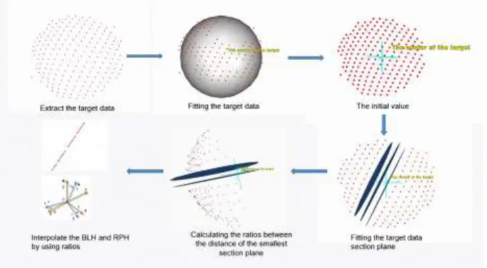
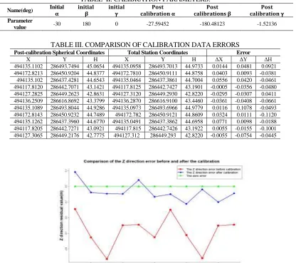
Research on Calibration Method of Vehicle Mapping
System based on Special Target
Xingwang Shen, Ming Guo and Shuzhuang Dong*
Institute of Mapping and Urban Spatial Information, Beijing University of Civil Engineering and Architecture, 102616 Beijing, China
ABSTRACT
In order to obtain the high-accuracy 3d data of roads and buildings, it is necessary to calibrate the relative parameters of the vehicle mapping system named MMS. At present, there are many disadvantages in most of the methods used in system calibration, such as the calibration points can not be picked with high precision, absolute precision is low and the method is hard to use. The paper explored a kind of rapid, convenient and accurate method of calibrate the relative parameters of the mobile mapping system. The analysis of precision experiments show that this method can make up for the shortcomings, applicability and practicability of the method compared with the traditional method. The overall level of precision is 0.05 m below the elevation accuracy reaches 0.06 m below. The accuracy and applicability of this method is fully satisfied with the precision requirement of the mobile's scanning system.
INTRODUCTION
Mobile mapping system is the most mainstream way to collect high precision point cloud of city roads, highways and buildings. Figure 1 shows the MMS, which integrated by GPS, inertial navigation, scanners and other sensors. Meanwhile, it shows the schematic from the original data ([Xlaser Ylaser Zlaser]T) to the final point cloud
([Xb Yb Zb]T) under Beijing urban coordinate system. Formula 1 shows the specific principle of point cloud data collection and it is also the calibration model.
[ Xb
Yb
Zb
] = [ Xgps
Ygps
Zgps
] + RM
[
RN[RO[
Xlaser
Ylaser
Zlaser
] + [ ∆XLI
∆YLI
∆ZLI
]]
] + [
∆XIG
∆YIG
∆ZIG
] (1)
Generally, it can be known that the original data can be accurate obtained by processing the raw data of the scanner. The matrix from the reference frame coordinate system to the local horizontal coordinate system RNand the matrix from the local horizontal coordinate system to the WGS84 longitude and latitude coordinate system
RM could be known by calculating the IMU data. The position of the GPS antenna
[Xgps Ygps Zgps]T could be gained by calculating the differential GPS data.
Therefore, it is important for the system by calibrate the installation error include the installing shift parameter [∆XLI ∆YLI ∆ZLI]T, [∆XIG ∆YIG ∆ZIG]Tand the installing
Figure 1. MMS and the calibration model.
There are many methods to calibrate the mobile scanning system. In the literature [1], it proposed the method of calibrate the external position element by using the control point. In literature [2], it proposed the method of calibrate the external position element by using feature surface. Literature [3] proposed a method to dynamically calibrate the external side parameters with a small Angle correction, and verified the calibration model of 12 parameters. Literature [4] proposed a method to calibrate the external position element by using three dimensions of vertical wall.
According to the installing rotate parameters, the paper proposed a calibration method of mobile scanning system by using a special spherical target. It can solve the problem such as hard to get the coordinates of the feature point/surface in high precision and so on.
THE METHOD AND EXPERIMENTAL DEMONSTRATION The Method
[image:2.612.246.351.543.611.2]The target is designed by using a level bubble to connect the spherical target and the reflector plate above which can make the center of them on the same plumb line as the Figure 2 shows. The real center coordinates of target can be measured by the total station. And the initial value of it can be obtained by fitting target. Because the fitting precision is high enough, it can solve the problem of obtaining the initial target data with high precision.
Figure 2. Special Target.
According to the calibration model, only R0 needs to be calibrated, so the other values have to be given the exact value first. For the spherical target, the initial
parameter R0 can be obtained by the design value and the installing shift parameters
between the center coordinates to the nearest two target section plane. The original data could be calculated by inverse calculation of the calibration model. The next step is calculate the finial installing rotate parameters by using the least squares principle of indirect adjustment. Last step is reprocessing the data by the parameters after the calibration. The Figure 3 shows the flow diagram of the method.
Extract and fitting the target data
Fit the Target section plane
Calculate the distance between each section and the center of target
Calculate ratio of two smallest distance
calculate parameters with interpolation
method Reverse calculate
the original data The least squares
calculation Recalculate the
[image:3.612.154.445.138.208.2]point cloud
Figure 3. The flow diagram of the method.
Experimental Demonstration
In order to verify the feasibility of the method, choosing a road as the calibration field. The special targets were placed in both sides which distribution are as Figure 4 shows. At the beginning of the experiment, the real value of the target could be confirmed through the reflector plate measured by the total station minus the fixed difference, then calibration started.
Figure 4. The distribution of the target.
Follow the flow chart above, the first step is to extract and fitting the target data into sphere. The initial value of the center of the sphere also could be achieved. Then classifying the scan line identified by ID. The second step is to fit each scan line into the plane. After fitting the plane, calculating the distance value between the center point of fitting sphere and the plane, through comparing the distance, calculate the ratio of the distance which are the two smallest. The third step is the interpolation. The BLH value
can be inverse calculated whose name is RM. Because the mobile scanning system is in
[image:3.612.184.414.352.453.2]Figure 5. Determination of spherical parameters.
TABLE I. COMPARISON OF RAW DATA ERRORS.
Initial Spherical Coordinates Total Station Coordinates Error
X Y H X Y H ΔX ΔY ΔH
494135.1199 286493.8050 44.8286 494135.0958 286493.7013 44.9733 0.0241 0.1037 -0.1447
494172.8253 286450.9233 44.5499 494172.7810 286450.9111 44.8758 0.0443 0.0122 -0.3259
494135.1352 286437.4260 44.2370 494135.0464 286437.3861 44.7004 0.0888 0.0399 -0.4634
494117.8215 286442.6971 42.9421 494117.8125 286442.7427 43.1901 0.0090 -0.0456 -0.2480
494127.3027 286449.1976 42.5775 494127.3120 286449.2930 42.8220 -0.0093 -0.0954 -0.2445
494136.2585 286616.8149 43.1209 494136.2870 286616.9100 43.4460 -0.0285 -0.0951 -0.3251
494135.1199 286493.8050 44.8286 494135.0973 286493.6966 44.9779 0.0226 0.1084 -0.1493
494172.8253 286450.9233 44.5499 494172.782 286450.9121 44.8609 0.0434 0.0112 -0.3110
494135.1352 286437.4260 44.2370 494135.0491 286437.3862 44.6958 0.0861 0.0398 -0.4588
494117.8215 286442.6971 42.9421 494117.815 286442.7426 43.1922 0.0065 -0.0455 -0.2501
494127.3027 286449.1976 42.5775 494127.312 286449.293 42.8220 -0.0093 -0.0954 -0.2445
The TABLE I shows that the overall accuracy is relatively poor by comparing the initial data with real data. The high accuracy of the whole station and the control network conform to the point accuracy of the calibration field. So some target were chosen as a calibration target. Making the point data collected by the total station with 0.5 second level accuracy as true value and making the initial spherical coordinates as observed values calculated by original parameters, using the method for calibration, through constant iterative calculation of the ultimate rotation parameters.
Through the calculation above, put the parameters into the calibration model, then calculating the model by using the least squares principle of indirect adjustment. In this step, the value obtained by the total station should be the known values and the center of target coordinates should be the observed value. Meanwhile, the installing rotate parameters should be the parameters need to be solved.
The observation equation in Matrix form is as follows:
V=BX-L (2)
Access:
X=(BTB)-1BTL (4)
parameter with the threshold, if it is bigger than threshold, put the finial parameter back to adjust again until it is smaller than the threshold and it is the final parameter we need. Because the design of this experiment is relatively perfect, the distribution of the target is reasonable, and the IMU system runs well, and it does not cause big disturbance to the final result as the TABLE II shows.
TABLE II. CALIBRATION PARAMETERS.
Name(deg) Initial 𝛂
𝐢𝐧𝐢𝐭𝐢𝐚𝐥 𝛃
𝐢𝐧𝐢𝐭𝐢𝐚𝐥 𝛄
𝐏𝐨𝐬𝐭 𝐜𝐚𝐥𝐢𝐛𝐫𝐚𝐭𝐢𝐨𝐧 𝛂
𝐏𝐨𝐬𝐭 𝐜𝐚𝐥𝐢𝐛𝐫𝐚𝐭𝐢𝐨𝐧𝐬 𝛃
𝐏𝐨𝐬𝐭 𝐜𝐚𝐥𝐢𝐛𝐫𝐚𝐭𝐢𝐨𝐧 𝛄 Parameter
value -30 180 0 -27.59452 -180.48123 -1.52136
TABLE III. COMPARISON OF CALIBRATION DATA ERRORS Post-calibration Spherical Coordinates Total Station Coordinates Error
X Y H X Y H ΔX ΔY ΔH
494135.1102 286493.7494 45.0654 494135.0958 286493.7013 44.9733 0.0144 0.0481 0.0921
494172.8213 286450.9204 44.8377 494172.7810 286450.9111 44.8758 0.0403 0.0093 -0.0381
494135.102 286437.4281 44.6543 494135.0464 286437.3861 44.7004 0.0556 0.0420 -0.0461
494117.8120 286442.7071 43.1421 494117.8125 286442.7427 43.1901 -0.0005 -0.0356 -0.0480
494127.2825 286449.2623 42.8631 494127.3120 286449.2930 42.8220 -0.0295 -0.0307 0.0411
494136.2509 286616.8692 43.3799 494136.2870 286616.9100 43.4460 -0.0361 -0.0408 -0.0661
494135.1089 286493.8044 44.9286 494135.0973 286493.6966 44.9779 0.0116 0.1078 -0.0493
494172.8143 286450.9232 44.7489 494172.782 286450.9121 44.8609 0.0324 0.0111 -0.1120
494135.1262 286437.3960 44.6770 494135.0491 286437.3862 44.6958 0.0771 0.0098 -0.0188
494117.8205 286442.7271 43.0921 494117.815 286442.7426 43.1922 0.0055 -0.0155 -0.1001
494127.3065 286449.2176 42.7775 494127.312 286449.293 42.8220 -0.0055 -0.0754 -0.0445
[image:5.612.93.509.144.513.2]
Figure 6. The error curve in three direction.
After calibrating the parameters of the model, the data is reprocessed and also fit the coordinates of the center of the sphere target again.
It can be concluded from the above table and chart named TABLEIII and Figure 6
[image:5.612.175.437.372.530.2]0.048423m, the mean square error in the H is 0.065878m. The accuracy can fully satisfy the needs of mobile scanning system. The calculation and analysis shows that the precision of MMS are very high, and the validation of the calibration method is successful.
CONCLUSIONS
This paper discussed the new method of calibrate three parameters of the mobile scanning system by the special spherical target. The method is verified through the calibration experiment used the special spherical target in different positions and directions. The accurate three parameters were obtained by calibrating the mobile scanning system. It shows that comparing with the point cloud data which were collected by the MMS without calibration, the accuracy of the point cloud data obtained by the mobile scanning system which were calibrated by using the method in this paper were improved both in absolute accuracy. It provides a strong guarantee for the rapid collection and application of 3d data.
REFERENCES
1. Kang, Yongwei; Zhong, Ruofei; and Wu, Minamu. 2008. “Study on the calibration method of external parameters of mobile laser scanner,” J. Infrared and laser engineering, 25(S3): 249-249. 2. Hu, Jing. 2011. “Research on the overall calibration method of mobile-mounted 3d laser mobile
modeling system,” D. Capital normal university.
3. Ye, Zetian; Yang, Yong; Zhao Wenji; and Hou Yanfang. 2014. “The dynamic calibration of the outer element of the on-board GPS/IMU/LS laser imaging system,” J. Journal of surveying and mapping, 40(03):345-350+372.
4. Tian, Ruixiang; Xu, Lijun; Xu,Teng; Li, Xiaobo; and Zhang, Qintuo. 2014. “The mobile LiDAR scanning system resettlement error Angle check school,” J. Infrared and laser engineering, 43(10):3292-3297.
5. D.A. Grejner-Brzezinska. 2001. “Direct Sensor Orientation in Airborne and Land-based Mapping Applications,”The Ohio State University Research Report, Geodetic Science and Surveying, pp. 461.
6. Barber, D., Mills, J., and Bryan, P. 2001. “Laser scanning and photogrammetry: 21st century metrology,” J. Proc., 18th Int. Symposium of CIPA, Potsdam, Germany, pp. 8.
7. C.M. Ellum and N. El-seimy. 2002. “Land-Based Integrated Systems for Mapping and GIS Applications,” J. Survey Review, 36(283): 323-339.
8. Zhao, H., and Shibasaki R. 2004. “Updating digital geographic database using mobile-borne laser scanners and line cameras. International Archives of Photogrammetry,” J. Remote Sensing and Spatial Information Sciences, 35 (3):111-119.
9. El-Sheimy, Naser. 1996. “The Development of VISAT A Mobile Survey System for GIS Applications,” D, University of Calgary, Calgary, Canada, pp.111-113.
10. Huntner G, Cox C., and Kremer J. 2006. “Development of A Commercial Laser Scanning Mobile Mapping System-StreetMapper,”.J, Processing of 2nd International Workshop of the future of Remote Sensing, pp.12-15.
11. Liang, Zuoqian; Ma, Hao; and Ruan, Yanling. 2013. “Boressight Misalignment Calibration of Airborne LiDAR System,” J. Science of Surveying and Mapping, 38(4):125-127。
12. Wang, Hui. 2015. “Error Analysis and Control of VchiclcBorne Laser Measurement System,” J. Journal of Geomatics, 40(4):70-72.