VOLUME 18 ISSUE 2 (2020), Page 193 – 205
STREET NETWORK DESIGN, PATTERN AND CHARACTERISTICS FOR MALAYSIAN LOCAL TOWN
Wan Saiful Nizam Wan Mohamad1, Ismail Said2, Khalilah Hassan3, Siti Nurathirah Che Mohd Nasir4, Mohammad Rusdi Mohd Nasir5, Nor Iza
Syazwani Lokman6
1, 3, 4, 5, 6 Department of Landscape Architecture
Faculty of Architecture and Ekistics
UNIVERSITI MALAYSIA KELANTAN
2 Department of Landscape Architecture
Faculty of Built Environment and Surveying
UNIVERSITI TEKNOLOGI MALAYSIA
Abstract
A large number of local towns with compare to another type of town in Malaysia notifying the variety which required further identification to highlight a standard in planning on this town category. Hence, this paper aims to define the basic criteria for street network of Malaysia's local town. Pasir Puteh, Baling, Rembau and Pontian were selected based on the diversity of the street network structure develop from beginning to the modern era. The towns were mapped using land use data. This study employed comparative analysis to assess similarity and differences on the principles and term of street network system. The finding suggests that local towns founded before independence retain the historical value of the street system built by the colonizer and new zone of local town is to serve the community rather than the administration. Thus, the research on how street network in local town influence vehicle or pedestrian movement is recommended.
Keywords:
Local town, street network, zoning characteristics, urban patterns,INTRODUCTION
A local town describes as a place where people live and use it as a center for managing everyday needs (Ahmadi et al., 2009; Said and Wan Mohamad, 2017). In Malaysian history, settlement's center has been built by the leader of the state as an early colonization era. While, some urban street network used to collect natural resources, such as tin or rubber. For instance, street network in Taiping used to extract tin from the mining area to the town and then to Port Weld (Kuala Sepetang) by bus. After Independence, although the towns governed by the Malaysian state, the designs of the streets were still the same as the colonization period. This similarity is due to the structures of the towns affected by the colonizers. Before the 90s, in the era of colonization and after independence, towns thrive into a community center from a set of settlements and then become a town (Ramele et al., 2010; Harun and Jalil, 2012). At the start of the modernization period in the 1990s, the towns were built based on the National Physical Plan and established from a master plan such as Proton City, Perak (Salleh and Abdul Aziz, 2006). Thus, the history of urban development has explained the existence of a variety of street network structures in today's local towns.
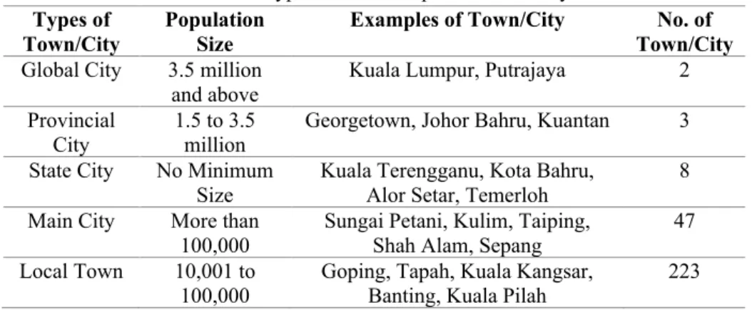
Table 1: Types of towns in peninsular Malaysia
Types of
Town/City Population Size Examples of Town/City Town/City No. of
Global City 3.5 million and above
Kuala Lumpur, Putrajaya 2
Provincial
City 1.5 to 3.5 million Georgetown, Johor Bahru, Kuantan 3 State City No Minimum
Size Kuala Terengganu, Kota Bahru, Alor Setar, Temerloh 8 Main City More than
100,000
Sungai Petani, Kulim, Taiping, Shah Alam, Sepang
47
Local Town 10,001 to
100,000 Goping, Tapah, Kuala Kangsar, Banting, Kuala Pilah 223
Source: JPBD, 2016; Mansor, 2011; SPAD, 2012
et al., 2010; Shamsuddin, 2011; Harun et al., 2013). Also, studies on the street network in cities are concentrated in major cities because of the rapid development of these types of towns (Moeinaddini et al., 2014). Thus, study on street network design, pattern, and characteristics is needed to understand local town as the dominant town for Malaysia. Therefore, this study aims to identify the street network criteria for Malaysia's local town consisting of zoning characteristics, street network design, and street network patterns. This study employed a depth study by Marshall (2005) in defining and understanding of the system and structure of street network in a town. The purpose of this study is to understand the characteristics as well as the structure of street network used to represent local town in Malaysia.
Zoning Characteristics
Towns in Malaysia were formed in the 1970s to the present in rapid development growth. Development experience shaped the physical of Malaysian local towns including the environment of the street network (Anwar et al., 2011; Mamat and Abdul Aziz, 2018; Mansor et al., 2012; Wan Mohamad & Said, 2014). Studies of urban morphology have explained the formation of the physical characteristics of local towns now formed by the ruler's ideology for the towns (Ahmadi et al., 2009). This formation clarified the zoning created based on their characteristics in Malaysian local towns (Wan Mohamad & Said, 2018). Harun and Jalil (2012) identified the three-stage development of towns in Malaysia during (i) the era of the Malay Sultanate, (ii) the era of colonialism, and (iii) the era of the Malaysian state. Accordingly, street network zoning characteristics in local towns are based on old zone physical identity (Malay Sultanate era and colonization era) and the new area (Malaysian government era).
Street Network Design
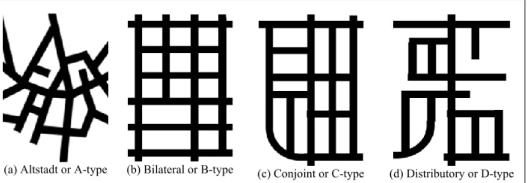
(a) Altstadt or A-type (b) Bilateral or B-type (c) Conjoint or C-type (d) Distributory or D-type
Figure 1: The form of street network design for ABCD typology principle
This study, therefore, used the typology of ABCD to be observed in defining the street network design in Malaysian local town. It involved A-type, B-type, C-type, and D-type street networks (Figure 1). This selection is because the intricate distinction in defining model types can help this study to explore the outcomes of street network structure in Malaysia.
Street Network Design
Street connections in town have created different patterns of street networks that influence street connectivity. There are 32 studies from 1920 to 2001, as recorded by Marshall (2005), that used different definitions of types of street network patterns in urban planning, transportation system and engineering management.
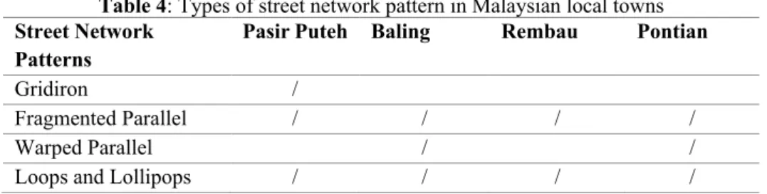
a) Gridiron b) Fragmented Parallel c) Warped Parallel d) Loops and Lollipops
Figure 2: The types of street network pattern
METHODOLOGY
There are 223 local towns in Malaysia, according to Table 2. There are two groups of urban centers, major and minor (Mansor, 2011). The former has 30,001 to 100,000 inhabitants. The minor, however, has a smaller population of between 10,001 and 30,000. Therefore, four towns were selected for discussion to understand the street network of local towns. To represent the major settlement center, Pontian and Baling were chosen. Pasir Puteh and Rembau were chosen for the minor middle. Towns are chosen similarly to have a fair decision towards the towns for both types of urban centers. The four towns were selected because they have different street network styles. Depending on the period the town began to exist, the establishment of their street network; the period is according to the colonization era, independent era, and modernization era. Besides, there are different types of street network design and street network patterns in the street network in those towns.
Table 2: Type of Urban Center in Malaysian Local Town
Urban Center Population
Size Examples of Town No. of Town
Major Settlement
Center
30,001 to
100,000 Baling, Kuala Selangor, Kuala Pilah, and Jasin 30
Minor Settlement
Center
10,001 to
30,000 Kuala Kangsar, and Kuala Perlis Pasir Puteh, Rembau, Raub, 193
Source: Mansor, 2011; SPAD, 2012
selected town. The findings from selected towns, therefore, have the potential to show the identity of street network for local towns in Malaysia.
RESULTS AND DISCUSSION
The findings of this study discussed according to the variables of the criteria, which consist of zoning characteristics, street network design, and street network patterns.
Zoning Characteristics of Malaysian Local Town
Figure 3 shows the zoning of the physical character identified in four towns, (a) Pasir Puteh, Kelantan, (b) Baling, Kedah, (c) Rembau, Negeri Sembilan, and (d) Pontian, Johor.
(a) Pasir Puteh, Kelantan (b) Baling, Kedah
(c) Rembau, Negeri Sembilan (d) Pontian, Johor
Legend
Old Town Characteristics – Old Zone Modern Town Characteristics – New Zone
The town with physical characteristics is categorized as an old area, particularly the street network that formed before Independence. The character of street network designs and patterns was influenced by the grid and radial European street network styles. Besides, the Malaysian government preserves the environment of the old zone under the National Urbanization Policy II (JPBD, 2016). For example, while travelling on the street network, people in Baling, Kedah, can still experience the old façade of shophouses with art decoration on windows. In Pontian, Johor, the trees with high and significant character show the characteristic of the ascent of the old zone. Baling, Kedah's colonial buildings demarcated the colonial era history. Similarly, the towns that preserved and maintained under the National Urbanization Policy II (JPBD, 2016) shows the old area possesses its unique heritage, such as history, architecture, identity, and environment that shaped the characteristics of the street network.
Colourful Shrubs Modern Design of Shophouses
Figure 4: Environment of Pontian, Johor as the eco-tourism town in Malaysia (2017)
characteristics of the old with different characteristics of the street network. During travel in Malaysian local towns, the variety of street network environment in old and new areas will optimize the representation of pedestrian actions.
Street Network Design of Malaysian Local Town
Table 3 shows three types of street network design identified from four selected towns, namely, bilateral (B-type), spousal (C-type) and distributor (D-type). The proposed street network for walking and carriage riding in Pasir Puteh also defines bilateral or B-type street network design. Walking in a grid shape, while walking on the streets, the layout provides four-way directions for the pedestrian. Whereas, street network design conjoint or C-type is a common type found at the town's expansion. This design is generally identified in new urban areas like Pontian and Rembau. The model was used in smoothing the traffic flow to support transport such as a car or bus. Finally, the layout of the street network with a hierarchical process is distributory or D-type. D-type design works in a hierarchy, collaborating with different types of streets, as opposed to B-type and C-type streets. In modern street networks, it is commonly found to differentiate the traffic flow depending on the particular area (Said and Wan Mohamad, 2017). Pontian Street, for example, is designed in Pontian as the main roads used to handle heavy traffic flow from other roads. Therefore, the model styles define the system in terms of travel mode, street hierarchy, and traffic flow to the street network in the towns. Therefore, in Table 3, the study of street network design for Pasir Puteh, Baling, Rembau and Pontian is provided in the identification of street network design for Malaysian town.
Table 3: Types of street network design in Malaysian local town
Street Network Design
Pasir Puteh Baling Rembau Pontian
Bilateral or B-type /
Conjoint or C-type / / / /
Distributory or D-type / / / /
among the four selected towns, Pasir Puteh is the only town with B-type street network design. This B-type identification shows that there are local towns in Malaysia with B-type street network design where walking and carriage riding were built, which created four-way directions. B-type was only available in some local towns, particularly the towns that were established during the colonization period (1511 to 1957). The C-type and D-type are therefore required to represent Malaysia's street network. Meanwhile, in Malaysian local town, the town which includes B-type presents the distinctive design of the street network. The town with a B-type has the character of the old design that influences pedestrian preferences in finding a path in the town.
Street Network Patterns of Malaysian Local Town
The street network patterns identified in four selected local towns are shown in Table 4. In Pasir Puteh, Baling, Rembau, and Pontian, there are two types of street network patterns that are fragmented parallel patterns as well as patterns of loops and lollipops. This identification means that street network patterns are based on those patterns in Malaysian local town. However, from the trends, this shows that, while walking and automobiles were the fundamental transportation modes, Malaysian local towns were quickly developed after Malaysian Independence in 1957. This indication describes that the streets were arranged with hierarchy in Malaysian local towns where there are streets for vehicles, pedestrians, and a mix of pedestrians and vehicles. Pontian Street, for instance, is known in Pontian as the main road for movement of vehicles, while Pantai Street is defined as a local road for mixed-use of pedestrians and vehicles.
Table 4: Types of street network pattern in Malaysian local towns
Street Network Patterns
Pasir Puteh Baling Rembau Pontian
Gridiron /
Fragmented Parallel / / / /
Warped Parallel / /
Loops and Lollipops / / / /
primary mode of travel was walking and carriage. The street network is distinguished by the old area which formed during the colonial era. However, since the National Urbanization Policy II does not list Pasir Puteh as a historic town, the character of the old zone is not well preserved (JPBD, 2016). The characters of the old shophouses façade at Pasar Lama Road, for example, are unobtrusive because the state did not license the area. As a result, the towns protected by the National Urbanization Policy II as a historic town are required for the gridiron-like street network in order to maintain the character as unique (JPBD, 2016). Hence, fragmented parallel patterns, as well as loops and lollipops, are compulsory to represent Malaysian local towns ' street network. In the meantime, the town with twisted parallel and gridiron patterns is reflecting the street network that had the preferences to change as necessary and granting the opportunity to influence street connectivity.
CONCLUSION
The identity of a street network of a local town is defined according to the criteria from 223 local towns listed in Malaysian, including population, type of urban center, zoning characteristics, street network designs, and street network patterns. Therefore, the street network requirements representing local towns in Malaysia are listed in Table 5.
Table 5: The criteria for street network of Malaysian local towns
Criteria Components Descriptions
Population 30,001 to 100,000 More population than minor settlement center
10,001 to 30,000 Less population than major settlement center
Types of Urban Center
Major Settlement Center Consist of two sets of boundaries Minor Settlement Center Consist of single set of boundary Zoning
Characteristics
Old Zone Preserved area by NUP 2 2016 as historic town
New Zone Area in the town developed after Malaysian Independence in 1957 Street Network
Designs
B-Type Identified in local town
C-Type Identified in local town
D-Type Identified in local town
Street Network Patterns
Loops and Lollipops Identified in local town
Based on the criteria shown in Table 5, understanding the identity of a street network for the local towns in Malaysia is evaluated. Local town population includes categories (a) 10,001 to 30,000 and (b) 30,001 to 100,000 leading to categorization of urban center type as either major settlement center or large settlement center. The physical characteristics create a town classification that only refers to a community that has an old and new area or a new zone. In particular, the town's old neighbourhood is protected and preserved as heritage towns under the National Urbanization Policy II (JPBD, 2016). Though, after Malaysian Independence in 1957, the town included as a new area is rapidly developing. Street network of Malaysian local town has advantages on designs because it has B-type, C-type and D-type layout. The street network patterns identified which are gridiron, fragmented parallel, warped parallel, as well as loops and lollipops represent the local town developed in the era according to different types of transport mode.
The discrepancies between two zoning features that are old and new areas in a town suggest an interpretation of a street network's identity portrays the local town's streetscape. The variety of street network layouts and street network patterns means that eliciting street network communication leads to the street network architecture system of local town. This research, therefore, demonstrates the importance of street network parameters in the field of urban planning to the fields of urban landscape design, architecture science, social behaviour, and environmental psychology. Accordingly, this study contributes to future research on how human behaviour that reflected from the criteria of street network in Malaysian local town.
ACKNOWLEDGEMENTS
The Ministry of Education Malaysia funds this study under Fundamental Research Grant Scheme, FRGS (Research Code: FRGS/1/2018/SSI11/UMK/03/1, R/FRGS/A1200/01672A/002/2018/00552).
REFERENCES
Ahmadi, V., Farkisch, H., Irfan, A., Surat, M., & Zain, M. F. M. (2009). A theoretical base for urban morphology: practical way to achive the city character. Journal of
Social Sciences and Humanities, 4(1), 30-39.
Anwar, W. F. F., Said, I., Ossen, D. R., & Rasyidi, M. H. (2011). Method to elicit local wisdom in perceiving the transformation of historical living environment. Journal
Harun, N. Z., & Jalil, R. A. J. (2012). The morphological history of the malaysian urban form. International Proceedings of Economics Development and Research, 48(24), 111-116.
Harun, N. Z., Mansor, M., & Said, I. (2013). The Experience of Diversity in Open Spaces of Two Historical Towns in Malaysia. Procedia - Social and Behavioral Sciences,
85, 582-591.
Hermawan, F., & Ismiyati. (2009). The density, road network pattern identification and isoprice perspectives. In International Conference on Sustainable Infrastructure
and Built Environment in Developing Countries. Bandung, West Java, Indonesia.
Jabatan Perancangan Bandar dan Desa (JPBD) (2016). National Urbanization Policy II: Federal Department of Town and Country Planning Peninsular Malaysia. Mamat, M. J., & Abdul Aziz, M. F. (2018). Early town planning system of small towns
in Perak. Journal of the Malaysian Institute of Planners. 16(4), 55-67.
Mansor, M. (2011). Experiential contacts of residents with green infrastructure network
in Taiping. (Doctor Philosophy), Universiti Teknologi Malaysia.
Mansor, M., Said, I., & Mohamad, I. (2012). Experiential Contacts with Green Infrastructure's Diversity and Well-being of Urban Community. Procedia - Social
and Behavioral Sciences, 49, 257-267.
Marshall, S. (2005). Street and Patterns: Spon Press.
Marshall, W. E., & Garrick, N. W. (2011). Does street network design affect traffic safety? Accid Anal Prev, 43(3), 769-781.
Marshall, W. E., Piatkowski, D. P., & Garrick, N. W. (2014). Community design, street networks, and public health. Journal of Transport & Health, 06.
Moeinaddini, M., Asadi-Shekari, Z., & Zaly Shah, M. (2014). The relationship between urban street networks and the number of transport fatalities at the city level. Safety
Science, 62, 114-120.
Ramele, R., Isnin, Z., & Jabar, I. L. (2010). Urban morphology of buffer zone and its survival in the historical city of Malacca. Journal of Built Environmental, 7(1), 35-41.
Said, I., & Wan Mohamad, W. S. N. (2017). Differences of sreet connectivity between old and new Zone in Malaysian small town. International Journal on Advanced
Science, Engineering and Information Technology, 7(4), 1464-1470.
Salleh, D., & Abdul Aziz, A. R. (2006). Konsep Pembangunan Bandar Baru Dalam
Pembangunan Wilayah. In Kepelbagaian Isu Dalam Pentadbiran dan
Pembangunan di Malaysia (pp. 66-80): Penerbit Universiti Utara Malaysia, Sintok.
Shamsuddin, S. (2011). Townscape Revisited: Unravelling the Character of the Historic: UTM Press.
Suruhanjaya Pengangkutan Awam Darat (SPAD) (2012). National land public transport
masterplan. Malaysia: Land Public Transport Comission.
Wan Mohamad, W. S. N., & Said, I. (2014). A review of variables of urban street connectivity for spatial connection. IOP Conference Series: Earth and
Wan Mohamad, W. S. N., & Said, I. (2018). Familiarity factors of street features in pedestrian wayfindings. International Journal of Built Environment and
Sustainability, 5(3), 201-207.