The Cryosphere, 4, 115–128, 2010 www.the-cryosphere.net/4/115/2010/
© Author(s) 2010. This work is distributed under the Creative Commons Attribution 3.0 License.
The Cryosphere
Role of glaciers in watershed hydrology: a preliminary study of a
“Himalayan catchment”
R. J. Thayyen1,2and J. T. Gergan1
1Wadia Institute of Himalayan Geology, 33-GMS Road, Dehradun 248001, India
2National Institute of Hydrology, Western Himalayan Regional centre, Jammu 180003, India Received: 22 June 2009 – Published in The Cryosphere Discuss.: 15 July 2009
Revised: 1 February 2010 – Accepted: 3 February 2010 – Published: 9 February 2010
Abstract. A large number of Himalayan glacier catch-ments are under the influence of humid climate with snow-fall in winter (November–April) and south-west monsoon in summer (June–September) dominating the regional hydrol-ogy. Such catchments are defined as “Himalayan catch-ment”, where the glacier meltwater contributes to the river flow during the period of annual high flows produced by the monsoon. The winter snow dominated Alpine catchments of the Kashmir and Karakoram region and cold-arid regions of the Ladakh mountain range are the other major glacio-hydrological regimes identified in the region. Factors in-fluencing the river flow variations in a “Himalayan catch-ment” were studied in a micro-scale glacier catchment in the Garhwal Himalaya, covering an area of 77.8 km2. Three hydrometric stations were established at different altitudes along the Din Gad stream and discharge was monitored dur-ing the summer ablation period from 1998 to 2004, with an exception in 2002. These data have been analysed along with winter/summer precipitation, temperature and mass bal-ance data of the Dokriani glacier to study the role of glacier and precipitation in determining runoff variations along the stream continuum from the glacier snout to 2360 m a.s.l. The study shows that the inter-annual runoff variation in a “Hi-malayan catchment” is linked with precipitation rather than mass balance changes of the glacier. This study also indicates that the warming induced an initial increase of glacier runoff and subsequent decline as suggested by the IPCC (2007) is restricted to the glacier degradation-derived component in a precipitation dominant Himalayan catchment and cannot be translated as river flow response. The preliminary assessment suggests that the “Himalayan catchment” could experience
Correspondence to: R. J. Thayyen
higher river flows and positive glacier mass balance regime together in association with strong monsoon. The important role of glaciers in this precipitation dominant system is to augment stream runoff during the years of low summer dis-charge. This paper intends to highlight the importance of creating credible knowledge on the Himalayan cryospheric processes to develop a more representative global view on river flow response to cryospheric changes and locally sus-tainable water resources management strategies.
1 Introduction
The role of high mountain areas of the world as an important source of freshwater for the population living in the adja-cent lowlands has been highlighted by readja-cent studies (Bandy-opadhyay et al., 1997; Viviroli and Weingartner, 2004; Bar-nett et al., 2005; Viviroli et al., 2007). The Himalaya is one of the focal regions, both in terms of its cryospheric re-sources and the dependency of a huge population on rivers originating from this mighty mountain chain. The Himalaya nourish more than 12 000 glaciers (Kaul, 1999; ICIMOD, 2001) covering an area of about 33 000 km2 (Rai and Gu-rung, 2005). River Ganga is being replenished by the melt-water from around 4000 glaciers spread over India and Nepal and River Indus is being fed by more than 3300 glaciers. Snow and glacier melt together with monsoonal precipita-tion determines the headwater flow regimes of large parts of the Himalayas, including central and eastern Himalayan trib-utaries of River Ganga and Brahmaputra. Snow and glacier melt contribution are very significant in many of these Hi-malayan rivers. On average, the annual snow and glacier melt contribution is estimated to be 60% in Satluj river at Bhakra dam (Singh and Jain, 2002), 49% in Chenab river at
Akhnoor (Singh et al., 1997) and 35% in Beas river at Pandoh (Kumar et al., 2007). The Himalayan cryospheric system, the largest outside the polar region, has a number of hydrological and climatic regimes, extending from the cold-arid regions of Ladakh to the humid monsoon climate of the north-eastern Himalayas (Mani, 1981). Glaciers in these regions are in a general state of recession since the 1850’s (Mayewski and Jeschke, 1979; Vohra, 1981; Dobhal et al., 2004; Kulkarni et al., 2007) with a few exceptions in the Karakoram region, which are advancing (Hewitt, 2005). As these glaciers con-tinue to recede, its impact on major glacier-fed rivers in the region is a matter of grave concern. The present understand-ing regardunderstand-ing the impact of glacier shrinkage on river flow variations has been discussed by the IPCC (2007a) which stated that “as these glaciers retreat due to global warming, river flows are increased in the short term, but the contribu-tion of glacier melt will gradually decrease over the next few decades” and that “the enhanced melting of glaciers leads at first to increased river runoff and discharge peaks and an increased melt season” (IPCC, 2007b). However, consider-ing the diverse climatic and hydrological regime of mountain glaciers across the world, such a uniform river flow response to glacier melting needs further evaluation. The Himalayan region has three dominant climatological regimes, which in-clude areas experiencing monsoon and winter precipitation, areas dominated by winter precipitation from western dis-turbances and cold-arid regions (Vohra, 1981). Therefore, a glacier’s role in influencing the flow regimes of moun-tain rivers across the Himalayan arc would vary considerably. The Dokriani glacier in the Ganga basin is one of the most studied glaciers in the Indian Himalaya and various facets of glacio-hydrological processes have been investigated ear-lier (Singh et al., 1995; Hasnain and Thayyen, 1999a, b; Hasnain, 1999; Thayyen et al.,1999, 2003, 2005a, b, 2009; Singh et al., 2000a, b, 2003a, b; Nijampurkar et al., 2002; Dobhal et al., 2004, 2008). In this work, an attempt has been made to highlight the fundamental differences between Alpine and Himalayan glacier hydrological systems and the role of glaciers in influencing runoff characteristics of mon-soon dominated “Himalayan catchments”.
2 Methods
2.1 Study area
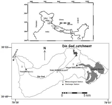
This study focuses on the “Himalayan catchments” of the Western Himalayan region, mainly on the Din Gad catch-ment in the Ganga basin. The basin-scale response of river flow during the past years has been studied in the nearby Satluj and Beas basins which extend from 30◦480to 32◦260N and 76◦580 to 78◦510E. The Din Gad catchment covers an area of 77.8 km2, extends from 2360 to 6000 m a.s.l. and has 9.6% glacierisation. The general aspect of this valley is NW which lies between latitude 30◦480to 30◦530N and longitude
78◦390to 78◦510E. Din Gad is the pro-glacial stream of the Dokriani glacier which joins Bhagirathi river near Bhukki village (Fig. 1). The length of the Dokriani glacier is 5.5 km and covers an area of 7 km2. This glacier has receded 726 m in 43 years (1962–2005) with an average rate of 16.8 m/yr and has lost approximately 22% of its volume from the total storage of 385×106m3 (Dobhal et al., 2004). The average accumulation rate of this glacier is 0.43 my−1(Dobhal et al., 2007; Nijampurkar et al., 2002), with an average accumu-lation area ratio (AAR) of 0.66. Another small glacier with an area of 0.46 km2 is also part of the Din Gad catchment, and its pro-glacial stream joins Din Gad at 3400 m a.s.l. just above the Gujjar Hut hydrometric station.
The Satluj basin lies north-west of the Ganga basin and the river flows down from China to India. The Indian part of the Satluj basin covers an area of 22 275 km2and 12% of the area is covered by glaciers and permanent snowfields and approx-imately 65% of the area receives winter snowfall (Singh and Jain, 2002). The Beas catchment shares its western bound-ary with the Satluj basin and has an area of 5278 km2 with 780 km2(14.7%) of glaciers and perennial snow cover (Ku-mar et al., 2007). The area and percentage glacier cover of various catchments discussed in this study are given in Ta-ble 1.
2.2 Data collection
R. J. Thayyen and J. T. Gergan: Role of glaciers in watershed hydrology 117
31
Fig. 1. Study area showing the sub- catchments and location of hydro- meteorological stations in the Din Gad catchment. Fig. 1. Study area showing the sub- catchments and location of
hydro- meteorological stations in the Din Gad catchment.
continuous recording of water level at these three stations, water level recorders were installed over the stilling wells made of steel drums. Manual observations of staff gauges were also carried out four times a day, with three hour in-tervals to overcome the problems arising from malfunction of the chart recorder during the high flow periods of June, July and August. The chart recording was disturbed many times during the study period due to high flows and other me-chanical problems. The Tela station was washed off during the high flows of July 2001. The daily discharge data have been calculated for the three stations by combining manual records and the data from the chart recorder. During the study period, the efficiency of rating curves of the glacier station ranged between 93–95.7% and that of the Gujjar Hut station between 90–94%. The efficiency of rating curves of the Tela station ranged between 87–91%. The Wadia Insti-tute of Himalayan Geology (WIHG), Dehradun and the Na-tional Institute of Hydrology (NIH), Roorkee monitored the discharge at the glacier station separately during the 1994 and 1998 ablation periods and the error was found to be in the range of 7–14%. In the absence of discharge data ac-quired through any other method, the inherent standard er-ror of 10–15% (Mutreja, 1986) in the area-velocity method of discharge measurement is deemed to be applicable in this study.
Three manual standard meteorological observatories were established at Tela (2540 m a.s.l.), Gujjar Hut (3483 m a.s.l.) and glacier Base camp (3763 m a.s.l.) and monitored throughout the ablation period. Monitoring of the winter weather was initiated at the Base camp station in 1998 and observations were carried out intermittently due to extreme
Table 1. Area and percentage glacier cover of various catchments discussed in the study (aReyaz and Shamshoo, 2008,bKumar et al., 2007,cSingh et al., 2002,dPuri and Swaroop, 1995).
Catchment
Catchment Area (km2) % Glacier cover Din Gad
(Dokriani glacier) 15.7 44.6
Din Gad (Gujjar Hut) 36.5 20.5
Din Gad (Tela) 77.8 9.6
Liddera 1263 3.1
Ganglass 70 1.6
Beasb 5278 14.7
Satluj(India)c 22 305 12
Gara Glacierd 17 35
Shaune Garang Glacierd 33.5 32.2
Tipra bank Glacierd 41.56 31.5
weather conditions. The winter weather monitoring was ex-tended to the Tela station in the year 2000. The standing snow depth and density were monitored four times during the December–April period at different altitudes along the valley bottom from Gujjar Hut to the Base camp. Snow depth and density measurements were extended up to 4700 m a.s.l. over the glacier at least once during April–May period to mon-itor the snow cover duration. The snow-line was mapped physically every year in early May, before initiating dis-charge measurement at Gujjar Hut and snout stations. The summer mass balance of the Dokriani glacier was estimated until 2000 to assess the glacier degradation-derived runoff component (Dobhal et al., 2008). The glacier melt derived runoff, equal to the glacier mass balance is termed as glacier degradation-derived runoff (UNESCO, 1996).
The regional similarities in runoff response at different spatial scales in the same glacio-hydrological regime were studied by using runoff data of Beas and Satluj rivers. The term discharge data from River Satluj, and the long-term all India summer monsoon rainfall anomalies were con-sidered along with information on glacier fluctuations in the Himalayas during the same period to understand the rela-tionship between monsoon strength and glacier fluctuation and the corresponding river flow response of the Himalayan catchment.
3 Hydrology of the Himalayan glacier catchments
The Himalayan region experiences diverse climate and hy-drology from west to east (Fig. 2), dominated by S-W In-dian monsoon in summer and mid-latitude westerlies known as western disturbances in winter (Upadyaya, 1995; Mani, 1981; Benn and Owen, 1998; Lang and Barros, 2004). While the S-W monsoon declines in strength from east to west
32
Fig. 2. Glacio-hydrological regimes of the Himalaya
Fig. 2. Glacio-hydrological regimes of the Himalaya.
along the Himalayan arc, western disturbances weaken as they move from west to east (Gupta, 1983). The hydrology of glaciers and glacier-fed rivers, east of the Chenab basin are highly influenced by the summer monsoon and these glaciers are considered as summer accumulation type glaciers (Ageta and Higuchi, 1984; Vohra, 1981). These large areas of the Himalaya constitute the headwater regions of the Ganga and a few tributaries of rivers Indus and Brahmaputra. The win-ter snowfall from weswin-tern disturbances dominates large areas of the Indus river systems. In India, the state of Jammu and Kashmir represents most of the winter snow dominated areas, where monsoon activity is very low. Another unique glacio-hydrological system in the Indian Himalaya is the cold-arid region of the Ladakh, which extends from Tibet to India. In this area, glaciers and permafrost melting are the major sources of water, sustaining the streamflow and water re-quirement of the population.
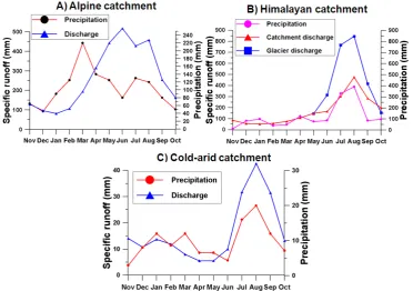
Each of these major glacio-hydrological regimes of the Hi-malaya are characterised by its differences in spatial and tem-poral distribution of precipitation and runoff. The area dom-inated by winter snowfall is analogous to the Alpine glacio-hydrological system, where peak glacier runoff contributes to otherwise low flow conditions, governed by lower pre-cipitation in summer (Fig. 3a). The Himalayan catchments in the east of the Chenab basin are characterised by peak glacier runoff contributing to peak river flow from monsoon rainfall in July and August (Fig. 3b). In the cold-arid re-gions of Ladakh, the annual discharge peak occurs in the month of July and August (Fig. 3c), mainly due to higher glacier melting during the period. The precipitation in the region is also the highest during the same period, but the mean annual precipitation is as low as 115mm (Gupta, 1983), in which 73% occurs during the summer months. The dis-tribution characteristics of precipitation in these three ma-jor glacio-hydrological regimes of the Himalaya are shown in Fig. 4. Here we define “the Himalayan catchment” as glacier catchments experiencing snowfall in winter and mon-soon precipitation in summer, where peak discharge from
the glacier contributes to the crest of the annual stream hy-drograph. Figure 5 is a schematic representation of these three different glacier hydrological systems of the Himalaya which shows the relative importance of the glacier, snow and rainfall in each of these glacio-hydrological regimes during the winter and summer months. Monsoon rains dominate the hydrology of “Himalayan catchments” from July to mid-September and snow from western disturbances dominates the winter months (NDJFMA). Consequently, December to March records the lowest flows in these rivers and the peak runoff occurs in the months of July and August. These two months experience the highest monsoon rains, highest solar insolation and temperature, which translate into the highest glacier discharge. Hence the headwater river hydrology of a Himalayan catchment is collectively influenced by variations in monsoon, snow and glacier regimes. This fundamental difference between the Alpine and the Himalayan glacier hy-drological systems is often overlooked, while assessing the role of glaciers in headwater river flows in a changing cli-mate. This is evident in the fourth assessment report of the Intergovernmental Panel on Climate Change (IPCC, 2007a) as it combined the Hindu Khush-Himalayan region and the South-American Andes together as the regions where river flow is sustained by the glacier melt in the summer season. In fact, major areas covering the southern slopes of the Hi-malaya, which include part of the Indus basin (Beas, Satluj & Ravi) and the whole of the Ganga basin and a few tributaries of River Brahmaputra in the eastern Himalaya, experience monsoon rains in summer and glacier melt only supplements to the peak summer flow. In this paper we focus our discus-sion on the “Himalayan catchment” as defined above.
R. J. Thayyen and J. T. Gergan: Role of glaciers in watershed hydrology 119
Role of glaciers in watershed hydrology: a preliminary study of a “Himalayan catchment”
R. J. Thayyen and J. T. Gergan (tc-2009-10) Corrections
Page 1 Line 6 Replace : 2National Institute of Hydrology, Western Himalayan Regional Centre, _India, too?
with
2
National Institute of Hydrology, Western Himalayan Regional centre, Jammu 180003, India
Page 5 Fig.3 : The axis titles of this figure look small after reducing its size. Please replace the figure with the following figure with enlarged axis titles.
Fig. 3. Temporal distribution of runoff and precipitation in glacio- hydrological regimes of the Himalaya in a mountain water year, showing characteristically different distribution pattern (A) snow dominant Alpine system, Lidder valley, Kashmir (B) monsoon dominant Himalayan catchment, Din Gad catchment, Ganga basin and (C) cold-arid system, Ganglass catchment, Ladakh range. Precipitation data are point observations made at lower part of the catchment.
34
Fig. 4. Figure showing comparative temporal distribution of precipitation amount in the three glacio-hydrologic regimes of the Himalaya. Fig. 4. Figure showing comparative temporal distribution of pre-cipitation amount in the three glacio-hydrologic regimes of the
Hi-malaya.
Burbank et al., 2003). The strength of the monsoon rain-fall declines above this altitude and glaciers in these regions receive lesser monsoon rainfall as compared to the lower al-titudes of the mountain range. The monsoon winds reach the Himalayan foothills by late June and persist until mid-September (Gupta, 1983) with July and August experiencing 80% of the monsoon precipitation.
Page 5 Fig.5 The altitude information in this figure is not readable after reducing its size. Please find the following figure with enlarged letter size for replacement.
Page 12: Bhutiyani, M. R., Kale, V. S., and Pawar, N. J.: Climate change and the precipitation variations in the northwestern Himalaya: 1866-2006, Int. Jour. Climatol., doi: 10.1002/joc.1290, 2009.
Reply:
Volume and article number of this article is not available as it is an Early view publication, published online by Wiley interScience on 09 April 2009
Please also add the following reference to the list of references in the Final author comment
Singh, P., Ramasastri, K.S., and Kumar, N.: Hydrological studies of Dokriani Glacier in the Garhwal Himalaya, in: Research highlights in earth system sciences, spl. Vol.1, edited by Varma, O. P., and Mahadevan, T. M., Indian Geol. Cong. , 213-228, 2000.
Fig. 5. Schematic diagram showing different glacio-hydrological regimes of the Himalaya and distribution of summer and winter pcipitation. The hypothesis proposed suggests varying river flow re-sponse to the cryospheric/climatic changes. (A) River flow changes are governed by the variations in summer and winter precipitation with higher glacier component during low summer runoff. (B) River flow changes are dependent on variations in the snow cover char-acteristics and glacier melting. (C) Rivers are entirely fed by the glaciers and permafrost melting and flow variation is governed di-rectly by the temperature variations.
4 Results and discussion
4.1 Variations in runoff and weather parameters
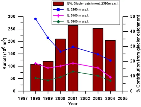
The Din Gad catchment experienced varied patterns of pre-cipitation during the seven-year study period. Heavy win-ter precipitation and summer monsoon rainfall in 1997–1998 and low winter and summer precipitation in 1998–1999 and 2003–2004 were the extremes. This situation provided a very good opportunity to study the role of glaciers in headwa-ter streamflow variations of a Himalayan catchment. The summer ablation season (May to October, M5-10) discharge in the Din Gad stream at 2360 m a.s.l. showed gradual re-duction during the study period. 2004 recorded the low-est discharge of 123×106m3, which was 58% less than the discharge observed in 1998 (290×106m3). Discharge ob-served at 3400 m a.s.l. recorded a 50% decline during the same period. However, discharge from the Dokriani glacier at 3800 m a.s.l. did not respond in the same way (Fig. 6). The glacier runoff fluctuated during these years, varying from 52×106m3in 1998 to the highest discharge of 78×106m3 in 2001 and the lowest value of 42×106m3 in 2004. The lowest discharge in all the three stations were recorded in the same year, while the highest discharge observed at the Tela station (2360 m) in 1998 was independent of glacier dis-charge. Glacier mass balance studies showed that the melt-ing of glacier ice contributed 4.83×10⁶m3to 5.17×10⁶m3 during 1994–2000 (Dobhal et al., 2007), which constituted 7.7 to 12.7% of the bulk glacier runoff. After considering the net accumulation ranges from 2.23×10⁶m3to 2.66×10⁶m3, the component of glacial degraded runoff in the bulk glacier discharge varied between 3.5–7.5%. During the study pe-riod, the Equilibrium Line Altitude (ELA) fluctuated be-tween 5030 m a.s.l. and 5100 m a.s.l. (Dobhal et al., 2008). At the non-glacierised part of the glacier catchment the tran-sient snowline often receded to 5800 m a.s.l. On average, the monsoon rainfall component in the glacier discharge was in the range of 10–26% (Thayyen et al., 2005a).
The Din Gad catchment experiences abundant rainfall during the ablation period from May to October (see sup-plementary material: http://www.the-cryosphere.net/4/115/ 2010/tc-4-115-2010-supplement.pdf). Summer rainfall in the Din Gad catchment range between 1533 mm in 1998 and 1080 mm in 2001 (Fig. 7) with a mean rainfall of 1249 mm. Winter snowfall experienced considerable variations during the study period. Winter precipitation monitored at the Base camp (3760 m a.s.l.) range from 500 and 511 mm w.e. in 1998 and 2002 to 144 and 190 mm w.e. in 1999 and 2004, respectively. The distribution characteristics of winter and summer precipitation in the catchment, especially in the higher reaches, are not fully understood from the present data. Yasunari and Inoue (1978) suggested that the mon-soon rainfall could be 4–5 times higher around the peaks and ridges of the catchment as compared to the valley bottom. Therefore, the assessment of snow and rainfall components
36
Fig. 6. Stream discharge variations observed at three elevations of the Din Gad catchment and corresponding variations in the contribution from the glacier catchment at 2360 m a.s.l. during the study period.
Fig. 6. Stream discharge variations observed at three elevations of the Din Gad catchment and corresponding variations in the contri-bution from the glacier catchment at 2360 m a.s.l. during the study period.
in the streamflow has not been attempted in this study. The longest snow cover durations at the Base camp was recorded in 1997–1998 (153 days) and in 2000–2001 (128 days). On the other extreme, the shortest snow cover duration during the study period were experienced in 1998–1999 (68 days) and 2003–2004 (75 days). In 1998, the snow cover in the first week of May was extended up to the Gujjar Hut station cov-ering 46% of the Din Gad catchment. The lowest snow cover area in May were recorded in 1999 and 2004, and amounted to 14 and 18%, respectively.
R. J. Thayyen and J. T. Gergan: Role of glaciers in watershed hydrology 121
37
Fig. 7. Observed variations in the hydro-meteorological parameters during 1998 - 2004
period. Rainfall, Positive degree days (PDD), winter snow precipitation, Snow cover duration at 3763 m a.s.l. and snow cover extent in the first week of May. Rainfall shown here is arithmetic mean of the rainfall observed at three stations in the Din Gad catchment.
Fig. 7. Observed variations in the hydro-meteorological parameters during 1998–2004 period. Rainfall, Positive degree days (PDD), winter snow precipitation, Snow cover duration at 3763 m a.s.l. and snow cover extent in the first week of May. Rainfall shown here is arithmetic mean of the rainfall observed at three stations in the Din Gad catchment.
4.2 Variations in the runoff contributions from glacierised and non-glacierised areas
Figure 6 explains the role of glaciers and precipitation in con-trolling river flow variations in the Himalayan catchment. While the discharge at Tela and Gujjar Hut stations dimin-ished by 58 and 50% respectively, from 1998 to 2004, dis-charge from the glacier catchment showed comparatively sta-ble response. Analysis of specific runoff from each sub – catchment showed that the contributions from the Tela catch-ment (41.8 km2)were reduced from 25 mm/day in 1998 to 9 mm/day in 2004 (Table 2). Similarly, runoff contribu-tion from the Gujjar Hut sub-catchment (20.3 km2)was re-duced from 18 mm/day to 4 mm/day during the same period, whereas the runoff from the glacier catchment (15.7 km2) varied from 29 to 15 mm/day. The variations observed in
the summer specific runoff from the non-glacierised part of the catchment covering 62 km2are obviously driven by the variations in precipitation. The lowest specific runoff from the glacier catchment observed during the study period was 15 mm/day, which is much higher than the lowest specific runoff of 9 mm/day and 4 mm/day of the non-glacierised Tela and Gujjar hut sub-catchments, respectively. This highlights the buffering role of the glaciers during the years of low summer flow in glacier-fed rivers of the “Himalayan catch-ment”. Highest specific runoff from the Tela sub-catchment (25 mm/day in 1998) observed during the study period was higher than the specific runoff from the glacier catchments in the same year and close to the highest runoff from the glacier catchment (29 mm/day in 2001). This shows that con-tributions from the non- glacierised part of the Himalayan catchment equals or even exceeds that of the glacier catch-ment during the years of abundant precipitation. This clearly shows the overwhelming influence of the precipitation, both winter snowfall and summer monsoon, in determining runoff variations in a Himalayan catchment.
Monthly discharge flux and percentage runoff contribution from the glacier catchment to Tela and Gujjar hut stations are shown in Fig. 8a and b. During the peak runoff period of July and August, the contribution from the glacier catch-ment to the Gujjar hut station ranged from 41% to 86%. At the same time, contribution from the glacier catchment to the Tela station ranged from 17% to 56%. During the 1998 ablation period, the component of glacier discharge at Gu-jjar hut and Tela stations were 47% and 18% respectively, where as in 2004, runoff from the glacier catchment con-stituted 74% at the Gujjar Hut station and 34% at the Tela station. This shows that the glacier component in the bulk discharge at the Tela station (2360 m a.s.l.) has nearly dou-bled during the study period. It is clear from the results psented above that the reason behind such a response is the re-duced runoff contribution from non-glacierised areas of the catchment, rather than any increase in the glacier discharge. Hence it is suggested that the discharge component from the glacier catchment is highest in the headwater streams of the “Himalayan catchment” during the years of lowest sum-mer runoff. Extending this response further downstream, Al-ford (1992) suggested that the Himalayan component is high-est in the Ganges during the years of minimum discharge. 4.3 Glacier discharge variations and role of glacier
degradation-derived component
The predominance of precipitation in determining the runoff characteristics of the Himalayan catchment is inclusive of the glacier catchment as well. Four years of mass bal-ance and runoff studies of Dokriani glacier show occur-rence of higher discharge in association with more positive glacier mass balance and lower discharge during more neg-ative mass balance years. 1999 experienced one of the low-est runoff from the glacier associated with highlow-est negative
Table 2. Observed variations in the specific mean daily runoff (mm d−1)of each sub-catchment of the Din Gad catchment during the summer period (M15-O30). Runoff variations in the Tela and Gujjar Hut sub-catchments are precipitation dependent and higher than the variation of the glacier catchment, illustrating the buffering role of the glaciers in a “Himalayan catchment” during the years of low summer runoff (CV – Coefficient of variation).
Sub-catchment Sub-catchment Sub-catchment Tela (41.8 km2) Gujjar Hut (20.3 km2) Glacier station (15.7 km2) Year (2360–3400 m a.s.l.) (3400–3800 m a.s.l.) (>3800 m a.s.l.)
1998 25 17 20
1999 17 15 16
2000 8 13 21
2001 9 10 29
2003 7 9 23
2004 9 4 15
CV 0.6 0.4 0.2
38
Fig. 8. Monthly variations in discharge and percentage contribution from the glacier catchment to the streamflow at A) Tela and B) Gujjar Hut stations. Fig. 8. Monthly variations in discharge and percentage contributionfrom the glacier catchment to the streamflow at (A) Tela and (B)
Gujjar Hut stations.
glacier mass balance. Similarly, 1994 and 1998 experienced higher glacier discharge in association with comparatively lesser glacier degradation (Fig. 9). Similar results were re-ported from other glaciers in the “Himalayan catchment” as well (Raina et al., 2008). The Geological Survey of India (GSI) studied glacier mass balance and glacier discharge at the Gara (1974–1981) and Shaune Garang glaciers (1983– 1989) in the Satluj basin and the Tipra bank glacier (1982– 1985 and 1989) in the Alaknanda (Ganga) basin for 5 to 7 years. The Gara and Shaune Garang glaciers even expe-rienced a couple of years of positive mass balance during the study period. The relationship between glacier discharge and
mass balance of these glaciers has also showed that the low- 39
Fig. 9. A) Ablation season discharge of Dokriani glacier and glacier degradation-derived runoff component, B) Enlarged graph of specific mass balance. Year 1994 and 1998 experienced high glacier discharge and low glacier degradation and year 1999 experienced one of the lowest summer runoff and highest negative glacier mass balance during the study period.
Fig. 9. (A) Ablation season discharge of Dokriani glacier and glacier degradation-derived runoff component, (B) enlarged graph of specific mass balance. Year 1994 and 1998 experienced high glacier discharge and low glacier degradation and year 1999 experi-enced one of the lowest summer runoff and highest negative glacier mass balance during the study period.
R. J. Thayyen and J. T. Gergan: Role of glaciers in watershed hydrology 123
40
Fig. 10. Relationship between net mass balance and mean daily discharge of glaciers in the precipitation dominant Himalayan catchment. Tipra bank, Shaune Garang, Gara and Dokriani glaciers show higher glacier discharge during the years of more positive glacier mass balance.(Data source: Tiprabank, Shaune Garang & Gara glaciers, Raina et al., 2008)
Fig. 10. Relationship between net mass balance and mean daily dis-charge of glaciers in the precipitation dominant Himalayan catch-ment. Tipra bank, Shaune Garang, Gara and Dokriani glaciers show higher glacier discharge during the years of more positive glacier mass balance (data source: Tiprabank, Shaune Garang and Gara glaciers, Raina et al., 2008).
catchments, which have lower percentage of glacier cover and precipitation dominance in the form of winter snowfall and summer monsoon. These glaciers lay deep in the val-ley and are surrounded by steep mountain slopes resulting in a lower percentage of glacierisation of the catchment. The glacier catchments discussed above have glacier cover rang-ing from 44.6% to 31.5% (Table 1). The Gangotri glacier catchment, encompassing the biggest glacier in the region also has only 51% glacier cover (Singh et al., 2008). This leaves out large non- glacierised area of these catchments, contributing snowmelt and monsoon rains directly to the glacier system which eventually emerges at the snout of the glacier. This is evident in the Dokriani glacier data as well. 1994 and 1998 experienced higher glacier discharge in asso-ciation with higher precipitation and lower glacier mass bal-ance. Whereas, 1999 experienced reduced glacier discharge due to lower precipitation in spite of receiving higher con-tribution from the glacier degradation-derived component. Hence, in a Himalayan catchment, precipitation plays a more dominant role than glacier degradation-derived component in determining the glacier runoff volume and its inter-annual variations. Raina et al. (2008) also indicated that any reduc-tion in the glacier melt during the positive balance year is more than compensated by the precipitation in the glacier catchment. With the precipitation and basin characteristics discussed above, the warming induced initial increase and subsequent decline of glacier runoff (IPCC, 2001; IPCC,
2007a, b) would remain as a response of glacier degradation-derived runoff component (UNESCO, 1996) in a Himalayan catchment. The relationship between glacier mass balance and glacier discharge of four glaciers discussed above sug-gests that the enhanced melting of glaciers need not necessar-ily translate into higher glacier discharge and river runoff in a precipitation dominant Himalayan catchment as suggested by the IPCC reports. Based on a survey in 1995, the vol-ume of fresh water locked up as ice in the Dokriani glacier is estimated to be 315×106m3(Dobhal et al., 2004). Com-pared to this storage, average yearly summer runoff from the Dokriani glacier catchment is 55×106m3, which is about 17.5% of the total glacier storage. Whereas, the annual glacier degradation-derived component in the bulk flow, as derived by the mass balance measurements was about 1% of the glacier storage and an average of 5% of the bulk glacier discharge. This also shows the overwhelming role of precip-itation in the runoff generation in a Himalayan glacier catch-ment.
4.4 Relationship between the monsoon, glacier response and river flow in a Himalayan catchment
Runoff variations of other nearby glacier-fed rivers in the recent past also buttress the point of view presented above. Runoff in the Satluj river at Bhakra in 2004 was 43% less than the 84-year normal and 50% less than the 1998 flow (Fig. 11). The decrease in the flow is much more than the 10% decline predicted under a 2◦C warming scenario for the same basin (Singh and Bengtsson, 2004). In a similar re-sponse, discharge of the Beas River at Pandoh Dam also di-minished during the 1990–2004 period (Fig. 12). Discharge of Beas river in 2004 was 29% less than the 14-year nor-mal and 44% less than the 1998 flow. A detailed assess-ment of discharge variations in these rivers has been car-ried out by Bhutiyani et al. (2008). Discharge variations in these rivers during 1998 to 2004 period were similar to the runoff response observed in the Din Gad catchment during the same period, suggesting a regional response of river flow to the prevailing climate of the region. A study of glaciers in the selected catchments within these basins and a nearby basin showed 21% deglaciation during the last four decades (Kulkarni et al., 2007), which clearly indicates that the ob-served flow variations in these rivers were precipitation de-pendent rather than glacier degradation dede-pendent, as we have observed in the Din Gad catchment.
In a Himalayan catchment, glacier fluctuation and corre-sponding river flow response are considered to be intrinsi-cally related to the strength of the monsoon. The growth of Himalayan glaciers is said to be linked to strong mon-soons as these glaciers are suggested to be the monsoon ac-cumulation type (Mayewski et al., 1980; Ageta and Higuchi, 1984; Benn and Owen, 1998). At the same time, a period of strong monsoon would invariably produce higher runoff in the glacier-fed streams. A study of runoff records of the
41
Fig. 11. a) Discharge anomalies of River Satluj at Bhakra from 1920-2004 and b) All-India summer monsoon rainfall anomalies from1871–2004. Shaded bars show probable periods of lower recession/stationery/advancement of many glaciers in the Himalaya and Trans- Himalayan region. The period between 1945 and 1960 was experienced high discharge in association with strong monsoon. Since the 1970’s widespread recession of glaciers are reported from the region, but with reduced runoff as compared to the 1950’s. (Data source: Haryana Irrigation Department, 2001; Singh & Jain, 2002; www.bbmb.gov.in; Mall et al., 2006).
Fig. 11. (a) Discharge anomalies of River Satluj at Bhakra from 1920–2004 and (b) All-India summer monsoon rainfall anomalies from 1871–2004. Shaded bars show probable periods of lower re-cession/stationery/advancement of many glaciers in the Himalaya and Trans-Himalayan region. The period between 1945 and 1960 was experienced high discharge in association with strong mon-soon. Since the 1970’s widespread recession of glaciers are reported from the region, but with reduced runoff as compared to the 1950’s (data source: Haryana Irrigation Department, 2001; Singh and Jain, 2002; www.bbmb.gov.in; Mall et al., 2006).
Satluj river along with all India summer monsoon anoma-lies (Mall et al., 2006) substantiates this unique river flow response to the glacier change in the Himalayan catchment (Fig. 11). An analysis of the runoff data for the Satluj river from 1920–2004 shows that the highest discharge in the river was observed during 1945–1965 in association with a period of strong monsoon. As a result, many glaciers in the Hi-malayan region probably experienced a positive mass bal-ance regime and showed signs of advbal-ancement or reduced rate of recession or were stationary during the 1950’s to early 1970’s (Mayawski et al., 1980; Vohra, 1993; Sharma and Owen,1996; Bhattacharyya et al., 2001). Since the mid-1960’s, runoff in the Satluj river has decreased compared to the discharge during the mid-1940’s and 1950’s. Con-currently, this period is also marked by widespread glacier recession in the region (Kulkarni et al., 2007; Thayyen et al., 2007b). The advancement of glaciers reported from the trans- Himalayan region during the 1890–1910 period is also attributed to the strong monsoon during the 1885–1900 pe-riod (Mayewski and Jeschke, 1979; Mayewski et al., 1980). This preliminary assessment proposes two important
charac-42
Fig. 12. Discharge (Pandoh) and rainfall variations in the Beas basin showing diminished runoff during the 1998-2004 periods. (Data source: Kumar et al., 2007) Fig. 12. Discharge (Pandoh) and rainfall variations in the Beas
basin showing diminished runoff during the 1998–2004 periods (data source: Kumar et al., 2007).
teristics of the “Himalayan catchment”: (1) it could expe-rience higher river flows and positive glacier mass balance regime together in association with strong monsoon and re-duced streamflow during the period of negative glacier mass balance. (2) The glacier melt component in the stream is highest during the years of low summer runoff.
R. J. Thayyen and J. T. Gergan: Role of glaciers in watershed hydrology 125 last century with winters warming at a faster rate (Bhutiyani
et al., 2007). These observations suggest that, on a synoptic-scale, the northwestern region of the Himalaya is experienc-ing weak summer precipitation and changes in the character-istics of winter snow cover during the last three decades in association with rising temperature. The observed river flow variations and widespread recession of glaciers in the region reflect these climatic changes.
Our present understanding of river flow response to the cryospheric changes (IPCC, 2001; Barnett et al., 2005; Hock et al., 2005; IPCC, 2007a, b) is dominated by the knowledge generated from areas where glacier meltwater is released dur-ing the periods of otherwise low flow conditions. The de-crease in the Northern Hemisphere snow cover (Armstrong and Brodzik, 2001; IPCC, 2007c) and world-wide reces-sion of glaciers (Oerlemans, 2005; IPCC, 2007c) illustrate the global response of glaciers and snow cover to the chang-ing climate. However, the river flow response to cryospheric changes is determined by the climate forcing on the regional hydrology, especially changes in precipitation characteris-tics. Therefore, there could be different streamflow responses to the cryospheric changes in different glacio – hydrologic regimes of the Himalaya. The suggested increase in river flow (IPCC, 2007a, b) from enhanced melting of glaciers may be possible for those hydrologic regimes, where cold-arid conditions and Alpine characteristics prevail. However, along the large tract of the “Himalayan catchment” east of the Chenab basin, where runoff from the precipitation is the primary flow component, the relationship between glacier response and changing precipitation characteristics of high mountain regions through the feedback mechanism (Meier, 1965) needs to be explored in more detail. Hence, a better understanding of the cryospheric system processes in each of these three distinct glacio-hydrological regimes of the Hi-malaya is imperative for evolving a reliable management and adaptive strategies for the region.
5 Conclusions
A “Himalayan catchment” is defined as a glacier catchment that experiences snowfall in winter and monsoon precipita-tion in summer with peak discharge from the glacier con-tributing to the crest of the annual streamflow hydrograph. The Himalayan catchment is one of the three distinct glacio-hydrologic regimes of the Himalaya. Winter snow dominated Alpine region and the cold-arid region of Ladakh range are the other two glacio-hydrological regimes identified in this study. A lack of long-term data on glacier mass balance and runoff in these glacio-hydrological regimes of the Hi-malaya remains a major constraint in bringing issues specific to this region into focus. This preliminary study suggests that the glacio-hydrological characteristics of the Alpine and the Himalayan catchment are significantly different. Hydrologi-cal characteristics of the precipitation dominant “Himalayan
catchment” ensure that the highest runoff in a stream occur as a result of high precipitation and the glacier component in the stream discharge is highest during the years of low summer runoff. Hence under normal circumstances glacier melting would not lead to high discharge or floods in a “Himalayan catchment”. Therefore, we suggest that the warming induced initial increase in discharge and the subsequent decline is a response limited to the glacier degradation- derived compo-nent of the runoff and need not necessarily translate as river flow response in precipitation dominant glacier systems as suggested by the IPCC (2001) and IPCC (2007a, b). The relative roles of the monsoons and western disturbances in the growth and decline of Himalayan glaciers are still in the realm of speculation (Benn and Owen, 1998). How-ever, a period of glacier growth seems to be closely linked with a period of strong monsoon and higher streamflow in a “Himalayan catchment”. Conversely, reduced streamflow could occur during the period of glacier shrinkage. Paucity of data and knowledge on the cryospheric systems processes across various glacio-hydrological regimes of the Himalaya remains to be the major impediment in formulating more rep-resentative global view on river flow response to cryospheric changes and locally sustainable water resources management strategies.
Acknowledgements. We thank D. P. Dobhal for constructive support during the fieldwork on Dokriani glacier during 1998–2000 periods. We highly appreciate the comments and suggestions by the reviewers, and the handling editor Stephen Dery which helped us to improve the manuscript. Data on Din Gad catchment were generated with a grant from the Department of Science &Technology, Govt. of India, under its nationally coordinated glaciology programme.
Edited by: S. Dery
References
Ageta, Y. and Higuchi, K.: Estimation of Mass Balance components of a summer-accumulation type glacier in the Nepal Himalaya, Geogr. Ann. A., 66A(3), 249–255, 1984.
Alford, D.: Mountain hydrological systems, Mt. Res. Dev., 5(4), 349–363, 1985.
Alford, D.: Hydrological aspects of the Himalayan region, ICIMOD occasional paper No. 18, Katmandu, 1992.
Armstrong, R. L. and Brodzik, M. J.: Recent northern hemisphere snow extent: A comparison of data derived from visible and microwave satellite sensors, Geophys. Res. Lett., 28(19), 3673– 3676, 2001.
Bandyopadhyay, J., Kraemer, D., Kattelmann, R., and Kundzewicz, Z. W.: Highland waters: A resource of global significance, in: Mountains of the world: A global priority, edited by: Messerli, B., and Ives, J., Parthenon, New York, 131–155, 1997.
Barnett, T. P., Adam, J. C., and Lettenmaier, D. P.: Potential impacts of a warming climate on water availability in snow-dominated regions, Nature, 438(17), 303–309, 2005.
Benn, D. I. and Owen, L. A.: The role of Indian summer monsoon and the mid- latitude westerlies in Himalayan glaciation- review and speculative discussion, J. Geol. Soc. London, 155, 353–363, 1998.
Bhattacharyya, A., Chaudhary, V., and Gergan, J. T.: Tree ring anal-ysis of Abies pindrow around Dokriani Bamak (Glacier), West-ern Himalayas, in relation to climate and glacial behavior: Pre-liminary results, Palaeobotanist, 50, 71–75, 2001.
Bhutiyani, M. R.: Mass-balance studies on Siachen glacier in the Nubra valley, Karakoram Himalaya, India, J. Glaciol., 45(149), 112–118, 1999.
Bhutiyani, M. R., Kale,V. S., and Pawar, N. J.: Long-term trends in maximum, minimum and mean annual air temperatures across the Northwestern Himalaya during the twentieth century, Cli-matic Change, 85, 159–177, doi:10.1007/s10584-006-9196-1, 2007.
Bhutiyani, M. R., Kale, V. S., and Pawar, N. J.: Changing stream-flow patterns in the rivers of northwestern Himalaya: implica-tions of global warming in the 20th century, Curr. Sci. India., 95(5), 618–626, 2008.
Bhutiyani, M. R., Kale, V. S., and Pawar, N. J.: Climate change and the precipitation variations in the northwestern Himalaya: 1866– 2006, Int. J. Climatol., doi:10.1002/joc.1290, in press, 2009. Burbank, D. W., Blythe, A. E., Putkonen, J., Pratt-Sitaula, B.,
Ga-bet, E., Oskin, M., Barros , T., and Ojha, P.: Decoupling of ero-sion and precipitation in the Himalayas, Nature, 426, 652–655, 2003.
Chase, T. N., Knaff, J. A., Pielke Sr., R. A., and Kalnay, E.: Changes in Global circulations since 1950, Nat. Hazards, 29, 229–254, 2003.
Dobhal, D. P., Gergan, J. T., and Thayyen, R. J.: Recession and morphogeometrical changes of Dokriani glacier (1962–1995), Garhwal Himalaya, India. Curr. Sci. India, 86(5), 692–696, 2004. Dobhal, D. P., Gergan, J. T., and Thayyen, R. J.: Mass balance and snout recession measurements (1991–2000) of Dokriani glacier, Garhwal Himalaya, India, Climatic and Anthropogenic impacts on the variability of the water resources, Tech. doc. Hydrol., (80), IHP-IV, UNESCO, 53–63, 2007.
Dobhal, D. P., Gergan, J. T., and Thayyen, R. J.: Mass balance stud-ies of Dokriani Glacier from 1992 to 2000, Garhwal Himalaya, India, Bull. Glaciol. Res., 25, 9–17, 2008.
Duan, K., Yao, T., and Thompson, L. G.: Response of monsoon pre-cipitation in the Himalayas to global warming, J. Geophy. Res. Earth, 111, D19110, doi:10.1029/2006JD007084, 2006. Goes, J. I., Thoppil, P. G., Gomes, H. R., and Fasullo, J. T.:
Warm-ing of the Eurasian landmass is makWarm-ing the Arabian sea more productive, Science, 38, 545–547, 2005.
Goswami, B. N., Ajayamohan, R. S., Xavier, P. K., and Sengupta, D.: Clustering of synoptic activity by Indian summer mon-soon intraseasonal oscillations, Geophy. Res. Lett., 30(8), 1431, doi:10.1029/2002GL016734, 2003.
Groisman, P. Ya., Karl, T. R., Knight, R. W., and Stenchikov, G. L.: Changes of snow cover, temperature and radiative heat balances over the northern hemisphere, J. Climate, 7, 1633–1656, 1994. Gupta, R. K.: The Living Himalaya (vol.1): Aspects of environment
and resource ecology of Garhwal, Today and Tomorrows printers and publishers, New Delhi, 1983.
Haryana Irrigation Department: Development of Haryana state wa-ter plan- Final Report. Haryana Irrigation Department,
Govern-ment of Haryana, 2001.
Hasnain, S. I. and Thayyen, R. J.: Controls on the major-ion chem-istry of the Dokriani glacier meltwaters, Ganga basin, Garhwal Himalaya, India, J. Glaciol., 45(149), 87–92, 1999a.
Hasnain, S. I. and Thayyen, R. J.: Discharge and suspended sed-iment concentration of meltwaters draining from the Dokriani glacier, Garhwal Himalaya, India. J. Hydrol., 218(3–4), 191– 198, 1999b.
Hasnain, S. I.: Runoff characteristics of a glacierized catchment, Garhwal Himalaya India, Hydrolog. Sci. J., 44(6), 847–854, 1999.
Hewitt, K.: The Karakoram Anomaly? Glacier expansion and the “Elevation Effect” Karakoram Himalaya, Mt. Res. Dev., 25, 332–340, 2005.
Hock, R., Jansson, P., and Braun, N.: Modeling the re-sponse of mountain glacier discharge to climate warming, in: Global Change and Mountain Regions (A State of Knowledge Overview), edited by: Huber, U. M., Bugmann, H. K. M., and Reasoner, M. A., Springer, Dordrecht, 243–252, 2005.
ICIMOD: Inventory of Glaciers, glacial Lakes and Glacial Lake outburst Floods, monitoring and early warning system in the Hindu Kush-Himalayan region, Nepal, (UNEP/RC-AP)/ICIMOD, Kathmandu, 2001.
IPCC.: Climate Change; Impacts, Adaptation and Vulnerability, edited by: McCarthy, J. J. and Canziani, O. F., Cambridge Uni-versity Press, Cambridge, UK, 2001.
IPCC, Kundzewicz, Z. W., Mata, L. J., Arnell, N. W., D¨oll, P., Ka-bat, P., Jim´enez, B., Miller, K. A., Oki, T., Sen, Z., and Shiklo-manov, I. A.: Freshwater resources and their Management, in: Climate Change 2007: Impacts, Adaptation and Vulnerability. Contribution of Working Group II to the Fourth Assessment Re-port of the Intergovernmental Panel on Climate Change, edited by: Parry, M. L., Canziani, O. F., Palutikof, J. P., van der Lin-den P. J., and Hanson, C. E., Cambridge University Press, Cam-bridge, UK, 173–210, 2007a.
IPCC, Rosenzweig, C., Casassa, G., Karoly, D. J., Imeson, A., Liu, C., Menzel, A., Rawlins, S., Root, T. L., Seguin, B., and Try-janowski, P.: Assessment of Observed Changes and Responses in Natural and Managed systems, in: Climate Change 2007: Impacts, Adaptation and Vulnerability. Contribution of Working Group II to the Fourth Assessment Report of the Intergovernmen-tal Panel on Climate Change, edited by: Parry, M. L., Canziani, O. F., Palutikof, J. P., van der Linden P. J., and Hanson, C. E., Cambridge University Press, Cambridge, UK, 79–131, 2007b. IPCC, Lemke, P., Ren, J., Alley, R. B., Allison, I., Carrasco, J.,
Flato, G., Fujii, Y., Kaser, G., Mote, P., Thomas, R. H., and Zhang, T.: Observations: Changes in Snow, Ice and Frozen Ground. in: Climate Change 2007: The Physical Science Basis. Contribution of Working Group I to the Fourth Assessment Re-port of the Intergovernmental Panel on Climate Change, edited by: Solomon, S., Qin, D., Manning, M., Chen, Z., Marquis, M., Averyt, K. B., Tignor, M., and Miller, H. L., Cambridge Univer-sity Press, Cambridge, UK and New York, NY, USA, 2007c. Joseph, P. V. and Simon, A.: Weakening trend of the southwest
monsoon current through peninsular India from 1950 to the present, Curr. Sci. India, 89(4), 687–694, 2005.
Kaul, M. K.: Inventory of Himalayan glaciers, Sp. Pub. No.34, Ge-ological Survey of India, 1999.
R. J. Thayyen and J. T. Gergan: Role of glaciers in watershed hydrology 127
Randhawa, S. S., Sood, R. K., and Dhar, S.: Glacial retreat in Himalaya using Indian remote sensing satellite data, Curr. Sci. India, 92(1), 69–74, 2007.
Kumar, V., Singh, P., and Singh, V.: Snow and glacier melt con-tribution in the Beas River at Pandoh Dam, Himachal Pradesh, India Hydrolog. Sci. J., 52(2), 376–388., 2007.
Lang, T. J. and Barros, A. P.: Winter storms in Central Himalayas, J. Meteorol. Soc. Jpn., 82(3), 829–844, 2004.
Mall, R. K., Gupta, A., Singh, R., Singh, R. S., and Rathore, L. S.: Water resources and climate change: an Indian perspective, Curr. Sci. India, 90(12), 1610–1625, 2006.
Mani, A.: The climate of the Himalaya, in: The Himalaya – As-pects of change, edited by: Lall, J. S. and Moddie, A. D., Oxford University press, Delhi, 3–15, 1981.
Mayewski, P. A. and Jeschke, P. A.: Himalayan and Trans-Himalayan glacier fluctuations since AD 1812, Arctic Alpine Res., 11(3), 267–287, 1979.
Mayewski, P. A., Pregent, G. P., Jeschke, P. A., and Ahmed, N.: Hi-malayan and Trans- HiHi-malayan glacier fluctuation and the south asian monsoon record, Arctic Alpine Res., 12(2), 171–182, 1980. Meier, M. F.: Glaciers and Climate, in: The Quaternary of the United States, edited by: Wright H. E and Frey D. G, Prince-ton University Press, New Jersey, 795–805, 1965.
Mutreja, K. N.: Applied Hydrology, Tata McGraw- Hill Publishing Company, New Delhi, 1986.
Nijampurkar, V., Rao, K., Sarin, M., and Gergan, J. T.: Isotopic study on Dokriani Bamak glacier, central Himalaya: implications for climatic changes and ice dynamics, J. Glaciol., 48, 81–86, 2002.
Oerlemans, J.: Extracting a climate signal from 169 glacier records, Science, 308, 675–677, doi:10.1126/science 1107046, 2005. Pant, G. B., Borgaonkar, H. P., and Rupakumar, K.: Climate
vari-ability over the western Himalaya since the little ice age: dendro-climatic implications, Hydrol. Rev. (INCOH), 18(1–2), 111–120, 2003.
Puri, V. M. K. and Swaroop, S.: Relationship of glacierized area and summer mean daily discharge of glacier basins in Jhelum, Satluj and Alaknanda catchments in Northwestern Himalaya, Geol. Surv. Ind. Spl. Pub., 21(2), 315–319, 1996.
Rai, S. C. and Gurung, A.: Raising awareness of the impacts of climate changes, Mt. Res. Dev., 25(4), 316–320, 2005.
Raina, V. K., Srivastava, D., Singh, R. K., and Sangewar, C. V.: Glacier regimen, fluctuation, hydrometry and mass transfer stud-ies in the Himalayas, in: Glacier Atlas of India, edited by: Raina, V. K. and Srivastava, D., Geol. Soc. India, Bangalore, 206–216, 2008.
Reyas, A. R. and Romshoo, S. A.: Snowmelt runoff modeling in Lidder basin of Kashmir Himalayas, in: Water resources in In-dia: Concerns, Conservation and Management (Abstracts), 1–3 November, CORD, Univ. Kashmir, 21–22, 2008.
Sharma, M. C. and Owen, L. A.: Quaternary glacial history of NW Garhwal, Central Himalayas, Quaternary Sci. Rev., 15, 335–365, 1996.
Singh, P., Ramasastri, K. S., Singh, U. K., Gergan, J. T., and Dob-hal, D. P.: Hydrological characteristics of the Dokriani glacier in the Garhwal Himalayas, Hydrolog. Sci. J., 40(2), 243–257, 1995. Singh, P., Jain, S. K., and Kumar, N.: Estimation of snow and glacier contribution to the Chenab River, Western Himalaya, Mt. Res. Dev., 17(1), 49–55, 1997.
Singh, P. and Kumar, N.: Effect of orography on precipitation in the western Himalayan region, J. Hydrol., 199, 183–206, 1997. Singh, P., Ramasastri, K. S., Kumar, N., and Arora, M.:
Corre-lations between discharge and meteorological parameters and runoff forecasting from a highly glacierised Himalayan basin, Hydrolog. Sci. J., 45(5), 637–652, 2000a.
Singh, P., Kumar, N., and Arora, M.: Degree-day factors for snow and ice for Dokriani glacier, Garhwal Himalayas, J. Hydrol., 235, 1–11, 2000b.
Singh, P. and Jain, S. K.: Snow and glacier melt in the Satluj River at Bakhra Dam in the Western Himalayan region, Hydrolog. Sci. J., 47, 93–106, 2002.
Singh, P., Haritashya, U. K., and Kumar, N.: Seasonal changes in meltwater storage and drainage characteristics of the Dokriani glacier, Garhwal Himalayas (India), Nord. Hydrology, 35(1), 15– 29, 2003a.
Singh, P., Ramasastri, K. S., Kumar, N., and Bhatnagar, N. K.: Suspended sediment transport from the Dokriani glacier in the Garhwal Himalayas, Nord. Hydrology, 34(3), 221–244, 2003b. Singh, P. and Bengtsson, L.: Hydrological sensitivity of a large
Hi-malayan basin to climate change, Hydrol. Process., 18, 2363– 2385, 2004.
Singh, P., Haritashya, U. K., and Kumar, N.: Modelling and estima-tion of different components of streamflow for Gangotri basin, Himalayas, Hydrolog. Sci. J., 53(2), 309–322, 2008.
Thayyen, R. J., Gergan, J. T., and Dobhal, D. P.: Particle size char-acteristics of Suspended sediments and subglacial hydrology of Dokriani Glacier, Garhwal Himalaya, India, Hydrolog. Sci. J., 44(1), 47–61, 1999.
Thayyen, R. J., Gergan, J. T., and Dobhal, D. P.: Glacier drainage evolution and control on suspended sediment concentration in meltwater, Dokriani glacier, Garhwal Himalaya, India, J. Geol. Soc. India, 62, 237–242, 2003.
Thayyen, R. J., Gergan, J. T., and Dobhal, D. P.: Monsoonal con-trol on glacier discharge and Hydrograph characteristics, A case study of Dokriani glacier, Garhwal Himalaya, India, J. Hydrol., 306(1–4), 37–49, 2005a.
Thayyen, R. J., Gergan, J. T., and Dobhal, D. P.: Lapse rate of slope air temperature in a Himalayan catchment – A study from Din Gad (Dokriani Glacier) basin, Garhwal Himalaya, India, Bull. Glaciol. Res., 22, 19–25, 2005b.
Thayyen, R. J., Gergan, J. T., and Dobhal, D. P.: Role of glaciers and snow cover on headwater river hydrology in monsoon regime: Micro scale study of Din Gad catchment (Dokriani Glacier), Garhwal Himalaya, India, Curr. Sci. India, 92(3), 376– 382, 2007a.
Thayyen, R. J., Goel, M. K., and Kumar, N.: Change estimation of selected western Himalayan glaciers, National Inst. of Hydrol., WHRC, Jammu, 2007b.
Thayyen, R. J., Gergan, J. T., and Dobhal, D. P.: Suspended sed-iment transfer in a Himalayan headwater stream: Glacier Vs Monsoon, in: Proceedings of the International conference on Water, Environment, Energy and Society, Vol. 1, Allied Publish-ers, New Delhi, 385–391, 2009.
UNESCO: Variations of snow and ice in the past and at present on a global and regional scale, edited by: Kotlyakov, V. M., IHP-IV Project H4.1, Paris, 1996.
Upadhyay, D. S.: Cold Climate Hydrometeorology, New Age Inter-national Publishers, New Delhi, 1995.
Viviroli, D. and Weingartner, R.: The hydrological significance of mountains: from regional to global scale, Hydrol. Earth Syst. Sci., 8, 1017–1030, 2004,
http://www.hydrol-earth-syst-sci.net/8/1017/2004/.
Viviroli, D., Durr, H. D., Messerli, B., Meybeck, M., and Wein-gartner, R.: Mountains of the world, water towers for humanity: Typology, mapping, and global significance, Water Resour. Res., 43, W07447, doi:10.1029/2006WR005653, 2007.
Vohra, C. P.: Himalayan Glaciers, in: The Himalaya: Aspects of change, edited by: Lall, J. S. and Moddie, A. D, Oxford Univer-sity press, Delhi, 138–151, 1981.
Vohra, C. P.: Himalayan Glaciers, in: Harnessing the Eastern Hi-malayan Rivers, Regional cooperation in South Asia, edited by: Verghese, B. G. and Ramaswamy, R. I., Konark Publishers, New Delhi, 59–69, 1993.