a
Sarasota County
'
Development
SARASOTA COUNTY LOW-IMPACT DEVELOPMENT MANUAL SARASOTA COUNTY 1001 Sarasota Center Blvd. Sarasota, Florida 34240 November, 2011
IF A HARDCOPY OF THIS
DOCUMENT IS NEEDED,
PLEASE TRY TO SAVE PAPER
AND PRINT THIS DOCUMENT
DOUBLE-SIDED.
This manual is available for download from the following website:
http://www.scgov.net/EnvironmentalServices/Water/SurfaceWater/LowImpactDevelop ment.asp
DISCLAIMER
While many developments share common elements, each is unique. The information in this manual is intended only as a starting point and guidance for the reader. It should be used only in conjunction with careful consideration of applicable laws, rules, codes, ordinances, standards, and the like including, without limitation, the Americans with Disabilities Act (“laws”) and interpretations of laws in effect at the time of a specific development. This manual does not change in any way the laws applicable to the planning, design, construction, operations, and maintenance of building and development projects in Sarasota County.
The authors have made a good-faith effort to provide timely and correct information. However, there may be some inaccuracies due, for example, to a change in applicable laws since publication. For this reason the authors cannot and do not represent or warrant the completeness or accuracy of the information. The information is supplied on the condition that the reader will make his or her own determination as to its suitability for his or her purposes. The responsibility for using a standard from this manual remains with the professional or other person responsible for planning, designing, constructing, operating, and maintaining a specific project.
TABLE OF CONTENTS
CHAPTER 1: MANUAL OVERVIEW
1.0 PURPOSE OF MANUAL ... 1-1 1.1 BACKGROUND ... 1-1 1.2 INTENDED USERS ... 1-2
1.3 ORGANIZATION OF MANUAL ... 1-2
1.3.1 Chapter 2: Evaluating Your Site and Planning for LID ... 1-3
1.3.2 Chapter 3: LID Practices for Sarasota County ... 1-3
1.3.3 Chapter 4: Permitting Guide ... 1-4 1.3.4 Appendices ... 1-4
1.4 DEMONSTRATING LID EFFECTIVENESS... 1-4
1.4.1 Water Quality ... 1-5 1.4.2 Water Quantity ... 1-5 1.5 LOCAL CONTEXT ... 1-5 1.5.1 Sarasota County Hydrology ... 1-5
1.5.2 Urbanization and Water Quality Standards ... 1-6
1.5.3 Standards Supporting LID ... 1-6 1.6 TERMINOLOGY ... 1-7 1.7 REFERENCES ... 1-12 1.8 APPENDICES ... 1-13
CHAPTER 2: EVALUATING YOUR SITE AND PLANNING FOR LID
2.0 OVERVIEW ... 2-1 2.1 SITE ASSESSMENT... 2-2 2.1.1 Defining Project Intent ... 2-3
2.1.2 Evaluating Predevelopment Conditions ... 2-3
2.2 SITE PLANNING AND DESIGN ... 2-5
2.2.1 Preserving Site Assets ... 2-5
2.2.2 Minimizing and Controlling Runoff Generation at the Source ... 2-6
2.2.3 Promoting Infiltration ... 2-7
2.2.4 Promoting Stormwater and Rainwater Harvesting ... 2-7
2.2.5 Minimizing Site Disturbance ... 2-8
2.3 PERFORMANCE MONITORING AND FEEDBACK MECHANISMS ... 2-8
2.4 PROJECT GUIDANCE ... 2-9 2.5 REFERENCES ... 2-11
CHAPTER 3: LID PRACTICES IN SARASOTA COUNTY
3.1.1 General ... 3.1-2
3.1.2 Design Considerations and Requirements ... 3.1-4
3.1.3 Design Procedure ... 3.1-10
3.1.4 Operation and Maintenance ... 3.1-12
3.1.5 References ... 3.1-14
3.2 PERVIOUS PAVEMENTS ... 3.2-1
3.2.1 General ... 3.2-2
3.2.2 Design Considerations and Requirements ... 3.2-4
3.2.3 Example Pervious Pavement Design Procedure ... 3.2-7
3.2.4 Construction ... 3.2-12 3.2.5 Operation and Maintenance ... 3.2-14 3.2.6 References ... 3.2-15
3.3 STORMWATER HARVESTING ... 3.3-1
3.3.1 General ... 3.3-2
3.3.2 Design Considerations and Requirements ... 3.3-7
3.3.3 Stormwater Harvesting Design Example ... 3.3-9
3.3.4 Construction ... 3.3-12 3.3.5 Operation and Maintenance ... 3.3-12 3.3.6 References ... 3.3-13
3.4 GREENROOF STORMWATER TREATMENT SYSTEMS ... 3.4-1
3.4.1 General ... 3.4-2
3.4.2 Design Considerations and Requirements ... 3.4-7
3.4.3 Cistern Design Procedure ... 3.4-11 3.4.4 Construction ... 3.4-13 3.4.5 Operation and Maintenance ... 3.4-14 3.4.6 References ... 3.4-15
3.5 RAINWATER HARVESTING ... 3.5-1
3.5.1 General ... 3.5-2
3.5.2 Design Considerations and Requirements ... 3.5-6
3.5.3 Rainwater Harvesting Example Calculation ... 3.5-11
3.5.4 Construction ... 3.5-15
3.5.5 Operation and Maintenance ... 3.5-15
3.5.6 References ... 3.5-17
3.6 DETENTION WITH BIOFILTRATION ... 3.6-1
3.6.1 General ... 3.6-2
3.6.2 Design Considerations and Requirements ... 3.6-5
3.6.3 Biofiltration Design Procedure ... 3.6-13 3.6.4 Operation and Maintenance ... 3.6-15 3.6.5 References ... 3.6-17
CHAPTER 4: PERMITTING GUIDE
4.2 COMPLIANCE WITH ERP “PRESUMPTIVE” CRITERIA ... 4-1 4.2.1 Shallow Bioretention ... 4-2 4.2.2 Pervious Pavement ... 4-3 4.2.3 Stormwater Harvesting ... 4-5
4.2.4 Greenroof Stormwater Treatment Systems ... 4-5
4.2.5 Rainwater Harvesting ... 4-6 4.2.6 Detention with Biofiltration ... 4-7 4.3 MAINTENANCE ... 4-8
LIST OF TABLES
Table 3.5-1 Average Monthly Rainfall Totals for Venice, Florida ... 3.5-12
LIST OF FIGURES
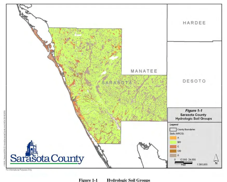
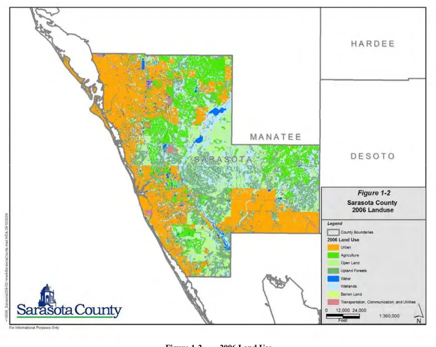
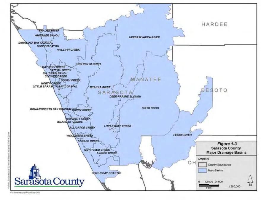
Figure 1-1 Hydrologic Soil Groups ... 1-14 Figure 1-2 2006 Land Use ... 1-15 Figure 1-3 Major Drainage Basins ... 1-16
Figure 2-1 LID Site Planning and Evaluation Guidance Chart ... 2-10
Figure 2-2 LID Site Planning Guide Legend ... 2-11
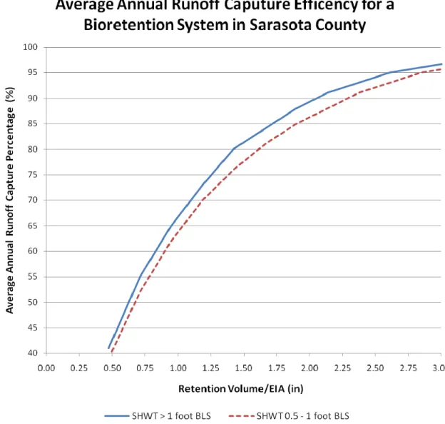
Figure 3.1-1 Plan View Illustrating a Shallow Bioretention System ... 3.1-3 Figure 3.1-2 Cross Section View of a Shallow Bioretention System ... 3.1-3 Figure 3.1-3 Average Annual Runoff Capture Efficiency for a Bioretention
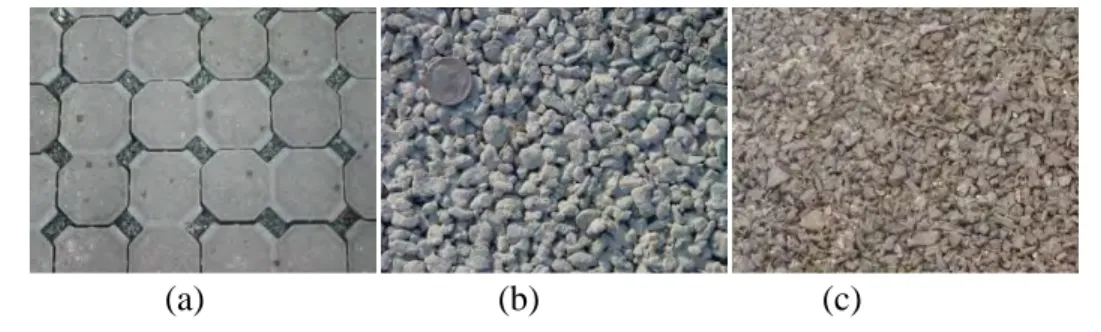
System in Sarasota County ... 3.1-9 Figure 3.2-1 Common Pervious Pavement Materials: a) Permeable Interlocking
Concrete Pavers, (b) Porous Concrete, (c) Flexi-paveTM ... 3.2-2
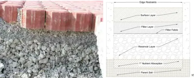
Figure 3.2-2 Typical Modular Paver Pervious Pavement System Cross Sections .... 3.2-3 Figure 3.2-3 Examples of Pervious Pavement (a: Parking Lot, b: Driveway, c:
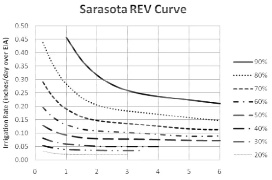
Walking Path) ... 3.2-3 Figure 3.3-1 Rate Efficiency Volume (REV) Curve for Designing a Harvesting
System for Sarasota County Florida ... 3.3-3 Figure 3.3-2 Schematic of Stormwater Pond with Irrigation Directly from the
Pond ... 3.3-4 Figure 3.3-3 Horizontal Well Construction Details ... 3.3-4 Figure 3.3-4 Comparison of a Horizontal Well and a Vertical Well ... 3.3-5 Figure 3.3-5 Example of the Nitrogen Removal Effectiveness of a Stormwater
Harvesting Pond ... 3.3-8 Figure 3.4-1 Example Greenroof ... 3.4-3
Figure 3.4-2 Example of Above-Ground Industrial Cistern Storage ... 3.4-3 Figure 3.4-3 Greenroof Stormwater Treatment System Schematic ... 3.4-4 Figure 3.4-4 Typical Passive Greenroof Section ... 3.4-4 Figure 3.4-5 Typical Active Greenroof Section ... 3.4-5 Figure 3.4-6 Greenroof Stormwater Treatment System Cistern Design Curve ... 3.4-6 Figure 3.5-1 Rainwater Harvesting with a Rain Barrel ... 3.5-2 Figure 3.5-2 Rainwater Harvesting for Irrigation and For Outdoor Use ... 3.5-3 Figure 3.5-3 Rainwater Harvesting for Graywater Supply and Outdoor Use ... 3.5-4 Figure 3.5-4 REV Curves for Rainwater Harvesting in Sarasota, FL with a
Constant Daily Demand ... 3.5-6 Figure 3.5-5 First-Flush Diverter (Oregon, 2009) ... 3.5-8 Figure 3.6-1 Plan View Illustrating a Detention System with Biofiltration ... 3.6-3 Figure 3.6-2 Cross Section View of a Detention System with Biofiltration ... 3.6-3 Figure 3.6-3 Cross Section View of System with Overflow ... 3.6-4 Figure 3.6-4 Average Annual Runoff Capture Efficiency for a Biofiltration
System in Sarasota County ... 3.6-11
APPENDICES
Appendix A: Rainfall and Runoff DataFigure A-1 Average Annual Rainfall Data for Sarasota and Vicinity ...A-1
Table A-1 Mean Annual Runoff Coefficient as a Function of DCIA
and Pervious CN ... A-2
Table A-2 Calculated Dry Retention Depth as a Function of DCIA
and Pervious CN ... A-3
Table A-3 Mean Annual Mass Removal Efficiencies for Zone 4 ...A-4
CHAPTER 1: Manual Overview
1.0 PURPOSE OF MANUAL
This manual provides technical guidance and design specifications on Low Impact Development (LID) stormwater management practices for application to projects in Sarasota County, Florida. This manual is not to be used in place of - but rather as a supplement to - Sarasota County and Southwest Florida Water Management District (SWFWMD) stormwater and surface water management guidance documents regarding local design criteria and LID applicability. The guidance provided in the manual is designed to be flexible with performance criteria provided where possible. Depending on the magnitude of specific or cumulative impacts, other methods of meeting the overall water resources objectives of Sarasota County and SWFWMD will be considered. For all projects, check with local officials and other agencies to determine additional restrictions and/or surface water or watershed requirements that may apply.
LID stormwater management practices are not mandatory in Sarasota County. However, Sarasota County does encourage the use of LID practices where possible to help meet its water resource objectives. This manual is expected to be adopted by the Sarasota County Board of County Commissioners and to be incorporated by reference into the Sarasota County ordinance.
1.1 BACKGROUND
Low-Impact Development (LID) is a stormwater management approach that uses a suite of hydrologic controls (structural and non-structural) distributed throughout the site and integrated as a treatment train (i.e., in series) to replicate the natural hydrologic functioning of the
landscape. Unlike conventional systems, which typically control and treat runoff using a single engineered stormwater pond located at the “bottom of the hill,” LID systems are designed to promote volume attenuation and treatment at or near the source of stormwater runoff via distributed retention, detention, infiltration, treatment, and harvesting mechanisms. The fundamental goal of applying LID concepts, design, and practice is to improve the overall effectiveness and efficiency of stormwater management relative to conventional systems,
reducing total and peak runoff volumes, and improving the quality of waters discharged from the site.
A site-specific suite of LID-integrated management practices can be applied to most if not all development scenarios in Sarasota County. Regardless of the project context, LID requires consideration of the following core site planning and design objectives:
1. Preserve or conserve existing site features and assets that facilitate natural
2. Minimize generation of runoff from impervious surfaces (i.e., use peak and total volume controls) and contamination (i.e., use load controls) as close to the source as possible.
3. Promote the distribution of retention, detention, treatment, and infiltration of
runoff.
4. Harvest stormwater on site.
5. Minimize site disturbance and compaction of soils through low-impact clearing,
grading, and construction measures.
The toolbox of LID-integrated management practices, including structural and non-structural
designs, is most effective when applied in a treatment train, or series of complementary
stormwater management practices and techniques. Typically, LID practices will not completely replace other more conventional “bottom-of-the-hill” stormwater management practices, but can be used to complement these practices and to ensure that the entire stormwater management system meets the Sarasota County and SWFWMD water resources objectives.
In addition, stormwater management that includes LID is most effective when sites are evaluated for LID compatibility as early as possible in the planning process and site conditions are
considered carefully in the design and construction of each LID practice. This manual supports Sarasota County’s goal of applying the LID concept and design where feasible to enhance existing stormwater management measures and reduce the adverse impacts of land development projects on the County’s natural resources.
1.2 INTENDED USERS
This LID Manual is intended to be used primarily by professionals engaged in planning, designing, constructing, operating, and maintaining building and development projects in Sarasota County. These potential users include but are not limited to stormwater design engineers, stormwater utility staff, natural resource managers, planning officials and
administrators, building officials, architects, landscape architects, site design specialists, and landscape operations and maintenance professionals.
1.3 ORGANIZATION OF MANUAL
In addition to this chapter, which provides an overview of LID concepts and principles and an introduction to the context for application of LID practices in Sarasota County, this manual contains three additional chapters and numerous appendices to provide guidance on the planning, design, construction, operations, and maintenance of LID projects in Sarasota County.
1.3.1 Chapter 2: Evaluating Your Site and Planning for LID
Chapter 2 focuses on the processes of site assessment, planning, and design for compatibility with LID principles and discusses mechanisms for integrating performance monitoring and feedback mechanisms at various stages of the development process. To ensure consistency with existing County land development and stormwater management rules and requirements, Chapter 2 directs users of this manual to those guidance documents by reference.
1.3.2 Chapter 3: LID Practices for Sarasota County
County-specific technical guidance on the design, construction, operations, and maintenance specifications for the following LID-integrated management practices are detailed in Chapter 3, “LID Practices for Sarasota County:”
Shallow Bioretention (Section 3.1)
Pervious Pavements (Section 3.2)
Stormwater Harvesting (Section 3.3)
Greenroof Stormwater Treatment Systems (Section 3.4)
Rainwater Harvesting (Section 3.5)
Detention with Biofiltration (Section 3.6)
Each section in Chapter 3 begins with an overview table that highlights the most critical
information for the specific LID practice covered in that section. These overview tables provide the following:
Key Practice Considerations, including intent, most suitable applications, design criteria, advantages/benefits, disadvantages/limitations, and maintenance
requirements.
Pollutant Removal Potential for total suspended solids, nutrients, metals, and pathogens, specified as ‘High,’ ‘Medium,’ or ‘Low’ relative to other LID practices, or ‘No Data.’
Stormwater Management Suitability for addressing water quality and volume attenuation criteria.
Implementation Considerations, including land requirement, capital cost, and maintenance burden, specified as ‘High,’ ‘Medium,’ or ‘Low’ relative to other LID practices; residential subdivision suitability, high-density/ultra-urban suitability, drainage area requirement, shallow water table considerations, and soils criteria.
Other Considerations critical for appropriate planning, design, construction, installation, operations, and maintenance of the LID practice or system.
Criteria provided in Chapter 3 are considered minimum standards for the design of LID treatment systems applied in Sarasota County. It is unlikely that any single LID practice will meet the SWFWMD and Sarasota County water resource objectives and it is intended that these practices be implemented in series with other LID practices and more traditional stormwater treatment practices—a treatment train approach. The stormwater treatment system (the treatment train) should be designed so that the entire system meets minimum stormwater control
requirements. It is important that users of this manual consult with SWFWMD Environmental Resource Permitting criteria and the County’s guidance documents on land development and stormwater management, including the County Comprehensive Plan, Land Development Regulations, and Zoning Code, for any variations to these criteria or additional standards that must be followed.
1.3.3 Chapter 4: Permitting Guide
Chapter 4 is a guide for applicants that elect to use LID treatment system design(s), and are using the LID treatment systems in conjunction with other traditional water quality treatment systems. Chapter 4 provides the acceptable minimum design criteria for the LID treatment systems to meet the current ERP Basis for Review and Sarasota County Land Development Regulation and provides design examples to illustrate how the applicant can use LID treatment systems to meet the water quality treatment requirement.
1.3.4 Appendices
Reference documents and data that provide necessary information and/or further technical guidance for the design, construction, and maintenance of Chapter 3 LID practices are provided in this manual as appendices. Examples of such appendices include rainfall tables for Sarasota County and a table of mean annual runoff coefficients.
1.4 DEMONSTRATING LID EFFECTIVENESS
Demonstrating the effectiveness of a stormwater treatment system will be a critical step in permitting a development in Sarasota County. This manual provides guidelines for
demonstrating the effectiveness of LID practices for meeting the appropriate water quantity and water quality requirements and standards.
1.4.1 Water Quality
The water quality effectiveness of a stormwater treatment system that includes LID practices must be quantified based on the reduction in the average annual pollutant load. The
effectiveness of the entire stormwater treatment system must be calculated by first calculating the effectiveness of each practice and then determining the effectiveness of the entire system. See Section 3.3.2.1 for an example of how this would be done for a stormwater harvesting system. Chapter 3 provides details, such as design curves, which can be used to calculate the average annual load reduction of some LID practices in Sarasota County.
1.4.2 Water Quantity
Most LID practices will provide some attenuation of peak flows and/or reduction in runoff volume during flood events. Typically, the effectiveness of the each LID practice at reducing peak runoff and/or runoff volume must be demonstrated by modifying the Natural Resource Conservation Service (NRCS) Curve Number (CN) that is used to represent the LID practice and/or the area contributing to the practice. Details on how the CN should be modified are provided in Chapter 3. In some instances it may be possible to explicitly model the structural controls of the LID practice, such as when permitting a stormwater harvesting system.
1.5 LOCAL CONTEXT
1.5.1 Sarasota County Hydrology
LID applications should be designed to mimic the natural hydrologic functioning of a site. Five hydrologic soil groups, as classified by the Natural Resource Conservation Service (NRCS), can be found in Sarasota County: Types A (well-drained), B/D (moderately well-drained when dry, not well-drained when wet), C (somewhat poorly drained), C/D (somewhat poorly drained when dry, not well-drained when wet), and D (poorly drained). A mapping of these hydrologic soil groups is provided in Figure 1-1. Note that most soils in Sarasota County are classified in the B/D hydrologic soil group due to a shallow Seasonal High Water Table (SHWT), so
performance of infiltration-dependent LID applications will be constrained under wet conditions in areas with these soil types.
Land use varies widely throughout the County. Most development has occurred near the coast, with pine flatwoods dominating the eastern half of the County. Land use according to
SWFWMD (2006) is mapped in Figure 1-2.
1.5.2 Urbanization and Water Quality Standards
Florida’s stormwater rules established goals for control and treatment of runoff from urban development. Criteria for the structural engineering of stormwater ponds were designed to (1) minimize flooding and, subsequently, damage to property and life by providing adequate drainage and flood control and (2) to achieve at least 85% average annual reductions in post-development pollutant loading.
While these stormwater rules and design criteria have been effective at addressing flood control and have facilitated an efficient process for managing stormwater runoff, recent research
indicates that they have fallen short of achieving established water quality goals (Harper and Baker 2007). Over 200 of Florida’s water bodies have been listed as impaired, meaning that they fail to achieve water quality standards established to maintain their designated use (potable water, shellfish propagation, recreation, etc.); nutrients in stormwater runoff – particularly nitrogen and phosphorus – have been identified as the cause of impairment in a majority of these waterbodies (FDEP 2006b).
1.5.3 Standards Supporting LID
Although they may not use the term “Low Impact Development” explicitly, many Sarasota County ordinances, resolutions, and policies and SWFWMD rules support the application of LID principles and design. County documents that should be referenced together with this manual for guidance on LID projects and to ensure compliance with requirements include but are not limited to the following:
Sarasota County Comprehensive Plan o Environment Plan (Chapter 2)
o Principles for Evaluating Development Proposals in Native Habitats
(Chapter 2)
o Watershed Management (Chapter 4)
o Future Land Use (Chapter 9)
Sarasota County Environment and Natural Resource Codes (Chapter 54, Sarasota County Code of Ordinances)
o Tree Protection Code (Article XVIII)
o Myakka River Protection Code (Article XXXIII)
Sarasota County Land Development Regulations (Chapter 74, Sarasota County Code of Ordinances)
o Environmental Technical Manual (Sec. 74-212)
Sarasota County Zoning Regulations (Appendix A, Sarasota County Code of Ordinances)
Regional watershed planning, floodplain protection, uplands preservation, wetlands protection, stream/watercourse protection buffers, riparian area and habitat protection; tree canopy
protection, density and clustering provisions, street-width requirements, and curb and gutter requirements are among the key land use, development, and natural resource management issues that must be considered when planning for LID, a process that is discussed in Chapter 2.
1.6 TERMINOLOGY
This section defines terminology used throughout this manual. Where possible, the applicable Sarasota County Code of Ordinance definition was used.
Average Annual Load Reduction: An estimate of the long-term average reduction in annual pollutant loading provided by a stormwater management practice. This is typically expressed as a percentage.
Average Annual Rainfall: The long-term average rainfall that occurs annually (See Figure A-1)
Bioretention: The use ofshallow landscaped depressions with soils, mulch, and planted vegetation intended to capture, treat, and infiltrate stormwater runoff.
Cistern: A closed reservoir or tank used for storing stormwater for stormwater harvesting.
Density: The number of residential dwelling units permitted per gross acre of land as determined
by the Sarasota County Zoning regulations. (SARASOTA COUNTY CODE OF ORDINANCES,CH.74,
ART I, § 74-7)
Detention: The delay of storm runoff before discharge into receiving waters. (SWFWMD 40d-Basis of Review)
Detention with Biofiltration: A landscaped depression area with a separate inlet and outlet (underdrain). Depressions are often linear and may be connected in series. Storage volume recovery of the depression is through an underdrain system. Other terms often applied to similar
practices include biodetention,bioswales, and vegetated swale.
Development: A subdivision of land or a site and development as defined by these regulations; a residential mobile home park; and any other construction whether residential, commercial, industrial, office, professional, institution, or recreational except a one- or two-family dwelling
Directly Connected Impervious Area (DCIA): Those impervious areas that are hydraulically connected to the conveyance system and then to the basin outlet point without flowing over pervious areas.
Easement: Any strip of land created by a subdivider for public or private utilities, drainage, sanitation, or other specified uses having limitations, the title to which shall remain in the name of the property owner, subject to the right or use designated in the reservation of the servitude. (SARASOTA COUNTY CODE OF ORDINANCES,CH.74,ART I, § 74-7)
Equivalent Impervious Area (EIA): The area of a completely impervious watershed that would produce the same volume of runoff as the actual watershed.
Exotic: A species introduced to Florida, purposefully or accidentally, from a natural range
outside of Florida. (SARASOTA COUNTY CODE OF ORDINANCES,CH.74,ART I, § 74-7)
Floodplain: Any land area inundated by flood events of various recurrence intervals as defined by the latest Federal Emergency Management Agency (FEMA) Flood Insurance Rate Map (FIRM), Sarasota County Basin Studies, or whichever data are, in the determination of the
County, more accurate. (SARASOTA COUNTY CODE OF ORDINANCES,CH.74,ART I, § 74-7)
Greenroof: A roof area built to the specifications of this manual that includes at a minimum vegetation, media, and a waterproof membrane. To receive water quality credit, it is specifically built with a cistern or water holding system from which irrigation is provided.
Grand Tree: Any tree that has been determined by the Administrator to have the characteristics as outlined in Section 54-586, Article XVIII of the Tree Protection Code or any tree designated a Florida State Champion, United States Champion, or World Champion by the American Forestry Association.
Graywater: That part of domestic sewage that is not carried off by toilets, urinals, and kitchen drains. Graywater includes waste from the bath, lavatory, laundry, and sink, except kitchen sink waste. (Florida Statutes 381.0065 (2)(d)).
Greenroof Stormwater Treatment System: A vegetated roof with a cistern that can be used for stormwater pollution control, volume reduction, and peak flow reduction.
Harvested rainwater is runoff from a roof that is conveyed from the roof to a cistern and then used. Harvested rainwater may be used for landscape irrigation, vehicle washing, or in other outdoor non-potable applications. The Sarasota County Health Department may approve using harvested rainwater indoors for toilet flushing, urinal flushing, laundry washing, Heating, Ventilating and Air Conditioning (HVAC) make-up water, or other indoor non-potable uses provided the water is filtered, adequately disinfected, and there is adequate protection from cross-connection. The Sarasota County Health Department may approve using harvested
rainwater for potable water provided the water is filtered, disinfected, and there is adequate protection from cross-connection. Harvested rainwater may not be used within the building envelope without prior approval of the Sarasota County Health Department or Sarasota County Development Services.
Invasive Species: For this manual, the acceptable listings of invasive species can be found in Sarasota County's Exotic Plant Code, Section 54-621, State regulations (Chapters 5B-57.007 and Chapter 62C-52.011 of Florida Administrative Code), the Florida Exotic Pest Plant Council's list of Category I and II invasive species as appropriate to this geographic region, as well as the
following species: Talipariti tiliaceum (Sea hibiscus). In addition, Sarasota County reserves the
right to develop additional lists of nonnative, nuisance, and invasive species.
Landscape Plant: Any native or exotic tree, shrub, or groundcover (excluding Turf). (SARASOTA
COUNTY CODE OF ORDINANCES,CH.54,ART XXXII, § 54-1023)
Littoral Zone: That portion of any lake, borrow pit, or pond measured from seasonal high water elevation in water bodies where water elevation is not controlled by structures or from the
overflow elevation in water bodies where water elevation is controlled by structures to a depth of 3 feet. Littoral zones also include those areas in salt or brackish water (gulf, bay, estuary) from
the mean high water elevation to a depth of 3 feet. (SARASOTA COUNTY CODE OF ORDINANCES,
CH.74,ART I, § 74-7)
Low-Impact Development:A stormwater management approach that uses a suite of hydrologic controls (structural and non-structural) distributed throughout the site and integrated as a treatment train (i.e., in series) to replicate the natural hydrologic functioning of the landscape.
Native: A species whose natural range included Florida at the time of European contact (1500
AD). (SARASOTA COUNTY CODE OF ORDINANCES,CH.74,ART I, § 74-7)
Nuisance: A species that threatens native species’ abundance or diversity or the stability of an
ecosystem or ecosystem process by its aggressive growth habit. (SARASOTA COUNTY CODE OF
ORDINANCES,CH.74,ART I, § 74-7)
Nutrient-absorption layer: A layer included in greenroof and pervious pavement systems, which absorbs nutrients, thereby reducing the nutrient loading from the system.
Pervious Pavement: A pavement system that allows stormwater to infiltrate into the parent soil.
Plan, Site: A scaled graphic and informational representation of a specific design solution for a development phase or the entirety on which is shown an area location map; existing and
proposed topography, streams, rights-of-way, easements, structures, wooded areas, and water bodies; provisions for ingress and egress; off-street parking, loading, refuse, and service areas;
proposed landscaping, fencing, screening, and buffering and provision for trees protected or required by County regulations; proposed signs and lighting; and any other information that may
be necessary or reasonably required. (SARASOTA COUNTY CODE OF ORDINANCES,CH.74,ART I,
§ 74-7)
Plan, Water Resource Management: A site-specific, comprehensive management plan prepared by a qualified environmental professional that details goals, actions, and BMPs (Best
Management Practice) used by the development to minimize any adverse environmental impacts. The plan shall include but not be limited to the following components: Water Resource
Management, including sources, uses, conservation, and water quality protection; Stormwater Management; Wastewater Treatment and Waste Management; Solid and Hazardous Waste Management; Chemical Waste Management (pesticides, oil, diesel, grease, etc.) and spills protocols; Integrated Pest Management; Fertilizer Management; Soils Management; Irrigation
Resources and Systems Management; and Groundwater Management. (DRAFTSARASOTA
COUNTY CODE OF ORDINANCES,CH.74,ART I, § 74-7)
Pollution-Control Credit: An estimate of the average annual load reduction achieved by a practice that can be counted towards the overall average load reduction achieved by the stormwater management system.
Pollution-Control Measures: Temporary or permanent management strategies that are applied to protect air and water quality by preventing or minimizing the pollution of the air, surface water,
and groundwater. (DRAFTSARASOTA COUNTY CODE OF ORDINANCES,CH.74,ART I, § 74-7)
Predevelopment: Conditions that exist on a site at the time of permit application. Unauthorized site preparation activities will not be considered as predevelopment conditions.
Preservation or Preserve: To set aside in perpetuity areas of native habitat that must not be disturbed in accordance with the Principles for Evaluating Development Proposals in Native
Habitats in the Environment Chapter of the Comprehensive Plan. (SARASOTA COUNTY CODE OF
ORDINANCES,CH.74,ART I, § 74-7)
Preservation or Preserve Trees: Those trees to be preserved as specified in a County Tree
Removal and Protection permit under Chapter 54, Article XVIII. Tree Protection. (SARASOTA
COUNTY CODE OF ORDINANCES,CH.74,ART I, § 74-7)
Pretreatment: Stormwater volume and/or water quality controls applied upstream from or before capture, storage, treatment, infiltration, and/or harvesting by a subsequent stormwater
management practice in a treatment train.
Rain Barrel is a rainwater storage vessel that captures runoff from a roof with a capacity less than or equal to 80 gallons. Systems using rain barrels for storage, including systems that link
several barrels together in series, do not constitute an acceptable BMP for the Environmental Resource Permit program administered by the Southwest Florida Water Management District.
Rainwater is runoff from a roof which is collected before it contacts the ground.
Reclaimed Water: Water that has received at least secondary treatment and which is reused after flowing out of a wastewater treatment facility. (Rule 62-600.200, Florida Administrative Code)
Redevelopment: The construction, installation, replacement, reconstruction, alteration, or other material change of a structure, impervious surface, drainage facility, or part thereof on a
previously developed site requiring a development order or permit. (DRAFTSARASOTA COUNTY
CODE OF ORDINANCES,CH.74,ART I, § 74-7)
Retention: The prevention of direct discharge of storm runoff into receiving waters; included as examples are systems which discharge through percolation, exfiltration, and evaporation
processes and which generally have residence times less than 3 days. (SWFWMD 40d-Basis of Review)
Seasonal High Water Table (SHWT): The elevation to which the ground and surface water can be expected to rise due to a normal wet season.
Soils: Defined in the current United States Department of Agriculture Soil Survey of Sarasota
County, Florida. (SARASOTA COUNTY CODE OF ORDINANCES,CH.74,ART I, § 74-7)
Stormwater Harvesting: Captured stormwater that is not allowed to discharge into a stormwater system or a natural conveyance system but is instead used for an activity such as irrigation.
Stormwater Harvesting Rate: The rate at which stormwater is harvested, which is typically expressed in inches per day.
Stormwater Harvesting System: Combination of a specified harvesting volume and rate of use intended to achieve a yearly average reduction in discharge mass; typically including a surface detention pond or other methods of storage.
Stormwater Management System: The appurtenances, facilities, and designed features of the property, which collect, convey, channel, hold, treat, detain, or divert, or otherwise manage
stormwater runoff. (DRAFTSARASOTA COUNTY CODE OF ORDINANCES,CH.74,ART I, § 74-7)
Stormwater Utility: A means of “funding of a stormwater management program by assessing the cost of the program to the beneficiaries based on their relative contribution to its need. It is operated as a typical utility which bills services regularly, similar to water and wastewater
Survey: A survey as defined in the Minimum Technical Standards for Surveying, Chapter 61617,
Florida Administrative Code. (DRAFTSARASOTA COUNTY CODE OF ORDINANCES,CH.74,ART I,
§ 74-7)
Treatment Train: An integrated series of stormwater management practices, each of which provides incremental stormwater attenuation and/or treatment benefits.
Turf: A piece of grass-covered soil held together by the roots of the grass. (SARASOTA COUNTY
CODE OF ORDINANCES,CH.54,ART XXXII, § 54-1023)
Waterbody: A natural body of water including rivers, lakes, streams, springs, ponds, and all other
natural bodies of water including tidal, fresh, brackish, and saline. (SARASOTA COUNTY CODE OF
ORDINANCES,CH.74,ART I, § 74-7)
Water Quality: A desired standard or degree of excellence defined by the physical, chemical, biological, and aesthetic characteristics of water in an attempt to preserve or attain its purest state
of having no contaminants. (DRAFTSARASOTA COUNTY CODE OF ORDINANCES,CH.74,ART I, §
74-7)
Water Quality Degradation: The natural and/or anthropogenic introduction of sediments and/or contaminants into ground or surface water that would result in a violation of State Water Quality Standards or that would prevent those waters from meeting designated present and future most
beneficial uses. (DRAFTSARASOTA COUNTY CODE OF ORDINANCES,CH.74,ART I, § 74-7)
Water Quality Monitoring Program: A comprehensive sampling program designed to assess the
surface water quality of a specific body or bodies of water that includes, but is not limited to, the
following components: Physical and chemical parameters; analytical methods; standard operating
procedures (SOPs); sampling locations; frequency and duration of sampling; and data analysis
and reporting. (DRAFTSARASOTA COUNTY CODE OF ORDINANCES,CH.74,ART I, § 74-7)
Water Quality Standards: Standards composed of designated present and future most beneficial uses (classification of waters), the numerical and narrative criteria applied to the specific water uses or classification, the Florida anti-degradation policy, and the moderating provisions contained in Chapter 62-4, F.A.C., adopted pursuant to Chapter 403, F.S. for surface water and
Rule 62-520-400, F.A.C. for groundwater. (DRAFTSARASOTA COUNTY CODE OF ORDINANCES,
CH.74,ART I, § 74-7)
1.7 REFERENCES
1. Florida Department of Environmental Protection. 2006a. Water Resource Implementation Rule, Chapter 62-40, Florida Administrative Code. May 7 2006.
2. Florida Department of Environmental Protection. 2006b. Integrated Water Quality Assessment for Florida: 2006 305(b) Report and 303(d) List Update. May 2 2006.
3. Florida Department of Environmental Protection. Environmental Resource Permitting and Sovereign Submerged Lands Rules. Accessed July 12 2008 at:
http://www.dep.state.fl.us/water/wetlands/erp/rules/stormwater.index.htm.
4. Harper, H. H. and D. M. Baker. Evaluation of Current Stormwater Design Criteria within the State of Florida: Final Report. Prepared for Florida Department of Environmental Protection. June 2007.
5. Jones Edmunds & Associates, Inc. Sarasota County County-Wide Non-Point Source Pollutant Loading Model. August 2005.
CHAPTER 2: Evaluating Your Site and Planning for LID
2.0 OVERVIEW
To achieve optimal performance of LID systems, project planners and engineers must adopt a comprehensive and iterative approach to site evaluation, planning and design, and monitoring
and feedback. This chapter provides guidance on the process of assessing a site and planning for
LID so that opportunities to protect water resources are maximized and adverse development impacts are minimized.
Site choice is the first decision affecting the success of LID applications to any project. When the project location is not predetermined, planners are encouraged to consider compatibility with LID principles and practices in their site selection, an approach that complements and/or satisfies Sarasota County’s development standards and stormwater management requirements.
The County’s Land Development Regulations, Article I Sec. 74-4, require development projects
to provide “adequate stormwater management [so as] to reduce the impact of flooding to a minimum” and “protection of Sarasota County’s natural systems and scenic resources, including the quality of air and both surface and groundwaters and the preservation of their ecological integrity.” Given that LID principles aim to reduce total and peak volumes of stormwater runoff, thereby reducing pollutant loading to receiving waters, applying them to a development
project—from site selection to long-term operations and maintenance—can help ensure that these County land-development standards are achieved.
Rather than focusing solely on treating stormwater runoff once it has been generated from a site, LID relies primarily on source controls and spatially distributed practices and systems that complement centralized, structured stormwater controls. Preserving the hydrologic signature of
a site to promote management of stormwater runoff volumes and quality at the source, integrated
with a series of on-site treatment practices, reduces the demand on centralized stormwater
treatment systems. This is typically referred to as a “treatment train” approach to stormwater management. While conventional stormwater design typically involves constructing a single retention or detention pond to meet volume storage and pollutant-control requirements for each basin, treatment-train design involves constructing multiple practices in series, where each individual practice provides incremental benefits that collectively achieve storage and pollution-control requirements. Project planners and engineers are encouraged to evaluate and design sites with a holistic perspective and in a fashion that is consistent with the treatment-train approach. Fundamental LID principles such as those listed below should be considered in the development planning and design process:
2. Minimize generation of runoff from impervious surfaces (i.e., use peak and total volume controls).
3. Minimize runoff contamination (i.e., use load controls) as close to the source as
possible.
4. Promote distributed retention, detention, treatment, and infiltration of runoff.
5. Capture and harvest stormwater on site.
6. Minimize site disturbance and compaction of soils through low-impact clearing,
grading, and construction measures.
In its overview of the site-assessment and planning processes, this chapter provides examples of specific LID practices supporting these principles. This chapter does not; however, address the average annual load reduction or the flood control that can be achieved by implementing such practices. Design standards and methods for calculating the effectiveness of certain practices are provided in Chapter 3. Applicants should discuss any practices not described in Chapter 3 with Sarasota County staff and SWFWMD staff at the pre-application meetings if they wish to include these as a part of their permitted stormwater treatment system.
2.1 SITE ASSESSMENT
In most development projects, stormwater systems are designed to attenuate and treat altered hydrologic conditions that result from implementing a master development plan. Plans for new development typically require the following:
Clearing onsite vegetation.
Disturbing and compacting native or parent soils.
Importing and grading fill material to establish the construction base and drainage
contours.
Constructing infrastructure to facilitate drainage away from the site.
Introducing new landscapes that require nutrient and water inputs greater than
natural conditions to thrive.
Rather than fitting the stormwater system into the predetermined site plan, LID encourages an alternative design approach that integrates existing site features that facilitate natural hydrologic functions into the master plan. LID systems are designed to use and enhance predevelopment hydrologic, soil, and landscape conditions that promote on-site interception, capture, storage, treatment, and infiltration of stormwater. Site assessment, the first step in implementing this type of LID approach to stormwater management, involves careful consideration of the project’s intent and thorough evaluation, documentation, and analysis of predevelopment site conditions.
2.1.1 Defining Project Intent
The type of development being planned, the expected uses, and the anticipated users of a site all have implications for effectively integrating LID features into the site, so these factors should be identified and documented early in any project. The applicant should consider the following questions regarding the project’s fundamental intent:
1. Is the project new or greenfield development, redevelopment or infill, or retrofit
of an existing site?
2. Is the property planned (and zoned) for residential, commercial, industrial, or
public use?
3. What local standards and/or programs offer incentives for and/or discourage
implementation of certain LID practices?
4. Who are the anticipated users of the site (primary and secondary) and what are the
project planners’ expectations of how they will use the site?
An approach that includes LID is compatible with all types of development; however, the suite of LID practices most appropriate for the project can vary significantly from one site to the next depending on the answers to the questions above. The list of practices that can be applied to new development of a relatively undisturbed site is usually extensive, ranging from opportunities to preserve tree canopy and natural depressions in the landscape to flexibility in sizing and location of stormwater ponds to allow for efficient capture and harvesting of stormwater. Potential practices appropriate for retrofit applications, on the other hand, might be limited in number because of existing site constraints yet can be extensive in terms of the potential design scenarios for practices that are appropriate. Zoning requirements for different land-use categories may support the construction of certain LID practices and limit or prohibit others.
Those who will be using the site and the manner in which they will be using it also can influence the appropriateness and effectiveness of LID systems. Stormwater systems in residential
applications, for example, are typically exposed and can often be accessed physically by homeowners, so it is important that LID applications not only function as stormwater quantity and quality measures, but also that they are perceived as functional community amenities rather than nuisances or hazards.
2.1.2 Evaluating Predevelopment Conditions
When evaluating a site for the feasibility of integrating LID practices, the project planner and/or engineer must conduct a thorough analysis of predevelopment conditions. For this manual, predevelopment conditions are site features – including both assets and constraints –as they currently exist on the site. For new development projects, this predevelopment might closely resemble a natural or native landscape, whereas for redevelopment it is likely to be altered
engineer should identify, understand, and document site conditions that facilitate rainfall
interception, capture, storage, evaporation, transpiration, infiltration, treatment, and harvesting. It is also important to note site features that restrict these natural hydrologic processes and to consider options for mitigating degraded conditions.
One way to begin this evaluation is to conceptually trace the path of rainfall as it moves within and through the site, considering, for example, the following types of questions:
What natural features (tree canopy, vegetation, etc.) intercept and/or capture rain
as it falls on the site and return portions of it to the atmosphere via evaporation and/or transpiration?
What is the topography of the site and does it promote stormwater drainage away
from the site or capture and infiltrate stormwater on site?
What are the hydrologic soil groups (as classified by the most current NRCS Soil
Survey for Sarasota County available at: http://websoilsurvey.nrcs.usda.gov/app/)
and distributions on site, and to what extent do they promote infiltration of rainfall (i.e., what are their infiltration rates)? As noted in Chapter 1, most soils in
Sarasota County are classified in the B/D hydrologic soil group (moderately well-drained when dry, not well-well-drained when wet) due to a shallow SHWT.
Where and to what extent have soils been disturbed and/or compacted, reducing
infiltration rates and promoting runoff generation?
What is the elevation of the seasonal high water table throughout the site?
Do critical and sensitive areas (wetlands, riparian areas, etc.) that provide capture,
uptake, and filtering of pollutants exist on site and have they been protected or disturbed?
What physical structures (buildings, parking lots, etc.) intercept rainfall and
convey it as stormwater to other areas of the site and/or away from the site?
What pervious surfaces (natural and structural) allow stormwater to infiltrate to
parent soils?
What impervious surfaces (natural and structural) prevent infiltration of
stormwater and promote runoff?
What engineered stormwater treatment systems exist on site and could they be
enhanced or retrofitted to improve performance?
The collective opportunities and constraints posed by predevelopment site conditions will directly influence the final suite of LID practices most appropriate for a site.
Planners and design engineers should assemble any available data and analyses that improve their understanding of predevelopment conditions and hire the appropriate Florida-registered and -licensed professionals to conduct additional surveys and/or inventories to fill important
information gaps. Recommended data sets and analyses to gather for the site and surrounding areas include but are not limited to the following:
Historical and current land-use maps
Aerial photographs
Road and utility surveys
Topographic and drainage maps
Floodplain and wetland maps
Riparian zone/stream buffer maps
Most current NRCS Soil Survey data for Sarasota County, (available at:
http://websoilsurvey.nrcs.usda.gov/app/) , or other historical soil information
Tree and vegetation surveys
Rainfall data
Hydrologic analyses
With these, data planners and design engineers can identify key site opportunities and constraints to LID, including those that affect the ability of the LID systems to control stormwater quantity and quality at the source, infiltrate stormwater on site, function effectively as a treatment train, and capture and store stormwater for harvesting.
2.2 SITE PLANNING AND DESIGN
Site planning for LID stormwater management is similar to planning for conventional stormwater management in that it applies structural engineered designs to meet stormwater quantity and quality criteria. LID site planning differs; however, in that it extends well beyond structural stormwater controls to include guidance on the fundamental design of a development; methods for protecting water quality and minimizing runoff generation at the source; practices that use physical, biological, and geochemical processes for stormwater treatment; and
innovative stormwater harvesting options. Most if not all LID practices provide multiple stormwater, environmental, and aesthetic benefits, but it is useful to consider the entire suite of practices that might be applied in terms of their relationship to the six fundamental LID
principles discussed in this manual:
1. Preserve existing site assets.
2. Minimize and control runoff generation at the source.
3. Promote infiltration.
4. Promote stormwater harvesting.
5. Minimize site disturbance.
6. Preserve onsite seasonal high water table
2.2.1 Preserving Site Assets
Planning for projects that include LID requires design that capitalizes on the beneficial features, or assets, of a site. A thorough inventory and composite analysis of site features helps the
project planner identify design options for conserving, preserving, protecting, and enhancing areas that promote LID function. These beneficial features include the following:
Tree canopy and “Grand Trees.”
Native species of vegetation.
Natural landscape depressions distributed throughout the site.
Native soils that have not been compacted or disturbed.
Stream buffers or riparian zones.
Careful management of these assets not only protects critical water resources, but can also
reduce or eliminate certain costs of site development, including those for clearing vegetation, site grading, and erosion control as well as post-development maintenance costs.
2.2.2 Minimizing and Controlling Runoff Generation at the Source
Conventional development practices modify natural site drainage pathways by introducing a network of impervious surfaces (rooftops, driveways, sidewalks, roads, and gutters) that route stormwater away from the site or to stormwater treatment basins. While this process is very efficient at controlling runoff, it alters the hydrologic signature of the site significantly, increasing volumes and rates of runoff while conveying pollutants away from the site.
Alternatively, LID emphasizes minimizing and controlling runoff and pollutant generation at the source. LID facilitates onsite infiltration by applying practices that preserve pervious surfaces, limit the total area of impervious surfaces introduced, and disconnect impervious surfaces. Source-control design strategies, whether applied to new residential, commercial, or industrial development, are valuable not only for achieving stormwater quantity and quality targets, but also for reducing site preparation and infrastructure costs. Among the key LID site-design practices that promote volume control and water quality protection at the source (subject to zoning code requirements or restrictions) are the following:
Preserving mature tree canopy, “Grand Trees,” and understory vegetation.
Clustering homes, buildings, and other structures on smaller lots.
Constructing greenroof stormwater treatment systems (Section 3.4).
Minimizing impervious areas.
Minimizing directly connected impervious areas (DCIA).
Using shared driveways in residential applications.
Using narrower roads with a pervious shoulder and/or right of way.
Using road layout that minimizes linear impervious area.
Using alternative parking lot design that minimizes total impervious area.
Designing landscapes that minimize turf or landscape plants with high nutrient
Designing landscapes that maximize preservation of existing native vegetation and introduce new vegetation that is appropriate for site conditions (e.g., Florida-friendly landscaping).
Irrigating for establishment only or use of smart water-application technologies,
such as soil moisture sensors, that maximize irrigation efficiency.
2.2.3 Promoting Infiltration
Many LID strategies that reduce generation of stormwater at the source do so by preserving and promoting opportunities for infiltration on site. While potential stormwater infiltration capacity and rates are constrained by predevelopment conditions such as SHWT and soil types,
infiltration-dependent LID practices can be designed to perform effectively as part of a treatment train under most site conditions in Sarasota County. Optimal areas for locating infiltration-dependent stormwater practices (i.e., those with the highest infiltration rates) should be identified during the site-assessment phase of development. Specific LID practices that preserve or
enhance infiltration function throughout the catchment basin include the following:
Retaining pervious surface areas.
Using bioretention applications.
Using pervious pavements (Section 3.2) for parking lots and residential parking
areas, driveways, walking and bike paths, sidewalks, and emergency vehicle access lanes.
Engineering or amending soils to improve infiltration properties.
Ecologically and biologically enhancing stormwater treatment ponds.
2.2.4 Promoting Stormwater and Rainwater Harvesting
Project planners and design engineers should consider stormwater itself as an asset that can be used to reduce the impact of development projects on Sarasota County water resources. Rather than designing systems that allow stormwater to leave the site, often exacerbating downstream flooding and surface water degradation, LID promotes treatment and harvesting of stormwater onsite. Stormwater harvesting can offset potable water demands significantly, particularly when used for outdoor irrigation, which accounts for approximately 50% of residential households’ (Purdum, 2002) water use in Florida. Specific stormwater harvesting practices, such as the following, should be considered in site planning:
Cisterns or rain barrels for collecting, storing, and using rainwater, air
conditioning condensate, graywater for irrigating lawns and landscape beds, irrigating green roofs, washing vehicles, cooling tower make-up water, and toilet flushing as approved by Sarasota County health codes etc.
Stormwater harvesting ponds, typically used for irrigating lawns and landscape beds (Section 3.3).
Distribution pipes for non-potable water (i.e. stormwater harvesting or reclaimed
water).
2.2.5 Minimizing Site Disturbance
Mechanisms to reduce site disturbance before, during, and after construction are some of the most critical elements of an integrated and effective approach to LID stormwater planning. Opportunities to preserve and promote natural hydrologic functioning of a site are often lost as a result of conventional development practices such as non-selective site clearing, export of native soils, importing of fill, mass grading, and construction in sensitive areas using heavy machinery. Compacting soils reduces the pore space available for storage and infiltration of stormwater. Some 80% of compaction occurs in the first pass of a vehicle across the soil, and compaction occurs to deeper depths in wetter soils. Clearing, grading, and construction measures that minimize site disturbance and promote LID function include:
Minimizing the clearing area.
Clearing selectively.
Using smaller and lighter construction equipment where possible.
Keeping heavy equipment outside of the drip line of preserved trees.
Minimizing grading and importing of fill (e.g., through use of stemwall
construction).
Keeping heavy equipment off soils where infiltration-dependent stormwater
practices will be used.
Designating laydown areas for construction equipment and materials.
Sarasota County stormwater regulations provide maximum allowable compaction values when constructing certain LID practices, such as pervious pavements (see Section 3.2).
2.3 PERFORMANCE MONITORING AND FEEDBACK MECHANISMS
Applicants should provide a plan for performance monitoring and feedback mechanisms to ensure that LID systems are operating as designed or, alternatively, to alert stormwater managers when either individual practices or the entire systems are not achieving performance goals. This plan should allow monitoring and feedback to occur through all project phases: before, during, and after construction. Specific monitoring and feedback requirements are defined for each practice in Chapter 3 of this manual; however, these requirements should be confirmed with Sarasota County and SWFWMD staff during the pre-application meetings. It should be noted that the performance requirements and recertification requirements for stormwater systems may differ between Sarasota County and SWFWMD.
2.4 PROJECT GUIDANCE
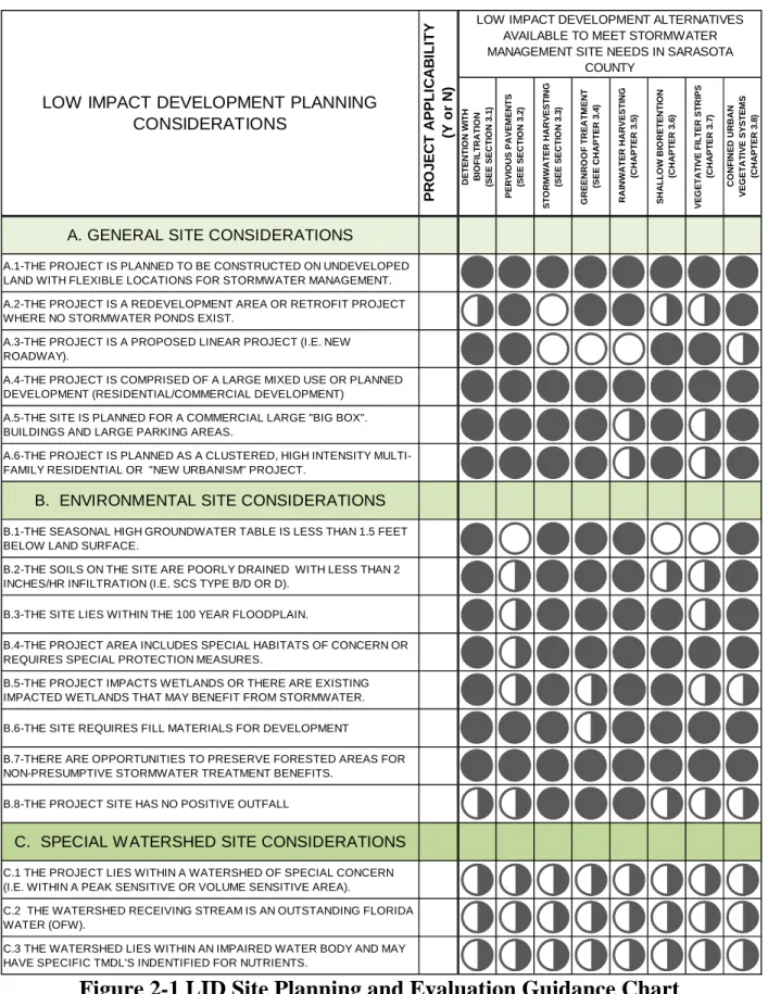
In order to achieve a “best fit LID practice” for each site, a qualitative LID Guidance Tool has been provided for applicants that follow a “consumers guide” approach to understanding the benefits or challenges of each LID practice in this manual. With this tool, the applicant can streamline the planning approach and focus on only those LID practices which are practical for application at each site according to three major categories: Refer to Figures 2-1 and 2-2.
THE LID GUIDE FOR PLANNING PROJECTS
A. General Site Considerations: What is the nature of the project?
B. Environmental Site Considerations: What natural features may provide opportunities
or influence LID performance?
C. Special Watershed Site Considerations: Are there any special stormwater
Figure 2-1 LID Site Planning and Evaluation Guidance Chart
DE T E N T IO N W IT H B IO F IL TR A T IO N (SEE SECT IO N 3 .1 ) PE R V IO U S PAVE M ENT S (SEE SECT IO N 3 .2 ) ST O RM W A T ER HA R V EST IN G (SEE SECT IO N 3 .3 ) GR E E N R OOF T R E A T M E N T (SEE C H APT ER 3 .4 ) R AI NW A T E R HAR V E S T IN G (C H APT ER 3 .5 ) SH AL L O W B IO RET E N T IO N (C H APT ER 3 .6 ) VE G E T A T IVE F IL T E R ST R IPS (C H APT ER 3 .7 ) CO N F INE D UR BAN VE G ET A T IV E SY ST EM S (C H APT ER 3 .8 )A. GENERAL SITE CONSIDERATIONS
A.1-THE PROJECT IS PLANNED TO BE CONSTRUCTED ON UNDEVELOPED LAND WITH FLEXIBLE LOCATIONS FOR STORMWATER MANAGEMENT. A.2-THE PROJECT IS A REDEVELOPMENT AREA OR RETROFIT PROJECT WHERE NO STORMWATER PONDS EXIST.
A.3-THE PROJECT IS A PROPOSED LINEAR PROJECT (I.E. NEW ROADWAY).
A.4-THE PROJECT IS COMPRISED OF A LARGE MIXED USE OR PLANNED DEVELOPMENT (RESIDENTIAL/COMMERCIAL DEVELOPMENT)
A.5-THE SITE IS PLANNED FOR A COMMERCIAL LARGE "BIG BOX". BUILDINGS AND LARGE PARKING AREAS.
A.6-THE PROJECT IS PLANNED AS A CLUSTERED, HIGH INTENSITY MULTI-FAMILY RESIDENTIAL OR "NEW URBANISM" PROJECT.
B. ENVIRONMENTAL SITE CONSIDERATIONS
B.1-THE SEASONAL HIGH GROUNDWATER TABLE IS LESS THAN 1.5 FEET BELOW LAND SURFACE.
B.2-THE SOILS ON THE SITE ARE POORLY DRAINED WITH LESS THAN 2 INCHES/HR INFILTRATION (I.E. SCS TYPE B/D OR D).
B.3-THE SITE LIES WITHIN THE 100 YEAR FLOODPLAIN.
B.4-THE PROJECT AREA INCLUDES SPECIAL HABITATS OF CONCERN OR REQUIRES SPECIAL PROTECTION MEASURES.
B.5-THE PROJECT IMPACTS WETLANDS OR THERE ARE EXISTING IMPACTED WETLANDS THAT MAY BENEFIT FROM STORMWATER. B.6-THE SITE REQUIRES FILL MATERIALS FOR DEVELOPMENT
B.7-THERE ARE OPPORTUNITIES TO PRESERVE FORESTED AREAS FOR NON-PRESUMPTIVE STORMWATER TREATMENT BENEFITS.
B.8-THE PROJECT SITE HAS NO POSITIVE OUTFALL
C. SPECIAL W ATERSHED SITE CONSIDERATIONS
C.1 THE PROJECT LIES WITHIN A WATERSHED OF SPECIAL CONCERN (I.E. WITHIN A PEAK SENSITIVE OR VOLUME SENSITIVE AREA).
C.2 THE WATERSHED RECEIVING STREAM IS AN OUTSTANDING FLORIDA WATER (OFW).
C.3 THE WATERSHED LIES WITHIN AN IMPAIRED WATER BODY AND MAY HAVE SPECIFIC TMDL'S INDENTIFIED FOR NUTRIENTS.
P R OJ E C T A P P L IC A B ILITY (Y o r N )
LOW IMPACT DEVELOPMENT ALTERNATIVES AVAILABLE TO MEET STORMWATER MANAGEMENT SITE NEEDS IN SARASOTA
COUNTY
LOW IMPACT DEVELOPMENT PLANNING CONSIDERATIONS
Figure 2-2 LID Site Planning Guide Legend
2.5 REFERENCES1. Purdum, E. D. (2002). Florida Waters: A Water Resources Manual from Florida’s Water Management Districts. Available: http://www.sjrwmd.com/floridawaters/index.html
(Accessed 05/29/2009).
THE LID PRACTICE IS BOTH FEASIBLE AND PRACTICAL AND IS RECOMMENDED FOR CONSIDERATION
THE LID PRACTICE MAY BE FEASIBLE BUT MAY REQUIRE SPECIAL MEASURES FOR PRACTICAL IMPLEMENTATION
THE LID PRACTICE POSES PRACTICAL CHALLENGES FOR IMPLEMENTATION THAT MAY LIMIT THE APPLICATION
LID SITE EVALUATION AND GUIDANCE LEGEND
NOTE: THE LID EVALUATION AND GUIDANCE TOOL IS PROVIDED TO AID STORMW ATER PROFESSIONALS IN PLANNING FOR SUCCESSFUL LID PROJECTS. THE STORMW ATER PROFESSIONAL IS ADVISED TO EVALUATE LID OPTIONS FOR EACH CATEGORY APPLICABLE
FOR THE PROPOSED PROJECT AS SHOW N IN FIGURE 2.2 AND THEN FOLLOW DESIGN RECOMMENDATIONS IN THE RESPECTIVE LID CHAPTER 3 SECTIONS. IT IS THE SOLE RESPONSIBILITY OF THE STORMWATER PROFESSIONAL TO DESIGN THE PROJECT TO EFFECTIVELY MEET BOTH SARASOTA COUNTY AND SW FWMD PERMITTING REQUIREMENTS
CHAPTER 3: LID Practices in Sarasota County
SECTION 3.1: Shallow Bioretention
3.1 SHALLOW BIORETENTION
Key
Considerations
Practice Intent:
Retain, infiltrate, and treat stormwater close to source. Design Criteria:
It is recommended for the drainage area to be 2 acres or less to be consistent with the goal of treating runoff as close to the source as possible.Treatment area consists of grass filter, ponding area, organic/mulch layer, planting soil, nutrient-absorption layer, and vegetation. Advantage/Benefits:
Applicable to small drainage areas.
Applicable to high water table conditions.
Good retrofit capability.
Can be planned as an aesthetic feature.
Disadvantages/Limitations:
Requires landscaping.
Maintenance Requirements:
Inspect and repair/replace treatment area components.
Remove trash, litter, and sediment.
Monitoring/Record Keeping:
Maintain record of fertilizer application.
Conduct biennial infiltration tests. Recovery:
Retention volume must be recovered within 72 hours.
Pollutant Removal Potential
H Total Suspended Solids
H Nutrients—Total Phosphorus/Total Nitrogen H/M Metals—Cadmium, Copper, Lead, and Zinc M Pathogens—Coliform, Streptococci, E.Coli Stormwater
Management Suitability
Water Quality
Volume and Flood Attenuation
Implementation Considerations
Residential Subdivision Use: Yes
High-Density/Ultra-Urban: Yes
Drainage Area:
It is recommended for the drainage area to be 2 acres or less to be consistent with the goal of treating runoff as close to the source as possible.
Shallow Water Table:
Seasonal High Water Table should be greater than 0.5 feet below retention area. Soils:
Planting soils must meet specified criteria; no restrictions on surrounding soils. Other
Considerations:
Use of native plants is highly recommended.
3.1.1 General
3.1.1.1 Overview and Intent
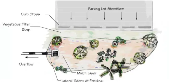
Bioretention areas are shallow depressions used as structural stormwater controls to capture, treat, and infiltrate stormwater runoff. Within the bioretention area, nutrient-adsorption media, soils, mulch, and planted vegetation facilitate treatment and remove pollutants from the runoff. Multiple bioretention areas are often distributed throughout a larger catchment, providing
numerous treatment and water storage areas. Although any one treatment area may be small, the cumulative effect can be significant. This distributed approach also better mimics
predevelopment hydrologic conditions by promoting stormwater infiltration, thereby reducing runoff and recharging groundwater.
3.1.1.2 Applicability
Water Quantity Control
Bioretention systems are designed primarily for addressing stormwater quality. Although bioretention systems will provide some attenuation of peak flows, they will most likely not provide sufficient storage capacity to meet Sarasota County and SWFWMD water quantity control criteria.
Water Quality Control
Bioretention systems can be more effective than conventional retention systems due to the increased interaction of stormwater runoff with soil, microbes, and vegetation enhancing
biogeochemical processes and improving water quality. Treating stormwater by bioretention can be very effective due to the variety of chemical, physical, and biological removal mechanisms.
Figure 3.1-1 Plan View Illustrating a Shallow Bioretention System