PDF hosted at the Radboud Repository of the Radboud University
Nijmegen
The following full text is a publisher's version.
For additional information about this publication click this link.
http://repository.ubn.ru.nl/handle/2066/127523
Please be advised that this information was generated on 2017-03-09 and may be subject to
change.
IMPLICATIONS OF BIOGEOMORPHIC
FEEDBACKS ON TIDAL LANDSCAPE
DEVELOPMENT
Implications of biogeomorphic feedbacks on
tidal landscape development
Christian Schwarz
2013
Digital version
Design and layout: Christian Schwarz
Implications of biogeomorphic feedbacks on tidal
landscape development
Proefschrift
ter verkrijging van de graad van doctor
aan de Radboud Universiteit Nijmegen
op gezag van de rector magnificus prof. mr. S.C.J.J. Kortmann,
volgens besluit van het college van decanen
in het openbaar te verdedigen op dinsdag 11 maart 2014
om 14.30 uur precies
door
Christian Schwarz
geboren op 15 september 1981
Promotoren:
Prof. dr. P.M.J. Herman
Prof. dr. L.Q. Zhang (East China Normal University Shanghai, CN)
Copromotor:
Dr. T. Ysebaert (NIOZ)
Manuscriptcommissie:
Prof. dr. J. Hendriks
Prof. dr. J.P. Bakker (RUG)
Prof. dr. Z.B. Wang (TUD)
Index
Chapter 1Introduction ... 9 Chapter 2
Abiotic factors governing the establishment and expansion of two salt marsh plants in the Yangtze estuary, China ... 21 Chapter 3
Plant traits and sediment characteristics influencing species
establishment ... 41 Chapter 4
Impacts of salt marsh plants on tidal channel initiation and
inheritance ... 61 Chapter 5
Impacts of a species invasion on geomorphologic processes in mature salt marshes ... 83 Chapter 6 Synthesis ... 105 Summary ... 119 References ... 125 Samenvatting Chinese Summary (摘要) Acknowledgements Curriculum Vitae
10 Chapter 1
Geomorphology and Biogeomorphology
The land surface is sculptured through interactions between driving and resisting forces. Driving forces, such as the force of gravity acting on water, wind and ice, solar radiation and the earth’s internal heat are contending against resisting forces, such as geologic structure, lithology and sediment properties sculpting landform characteristics [Leopold and Leopold, 1995]. Geomorphology investigates and describes the produced landform characteristics and analyses the processes forming and modifying them. In an estuarine setting, which is the focus of this thesis, the main driving forces are related to hydrodynamics (e.g. flow velocities and wave motion), whereas the main resisting forces are represented by bed stability (erodibility) [Winterwerp and Van Kesteren, 2004].
Biogeomorphology studies the impact of organisms (i.e. animals or plants) on interactions between the above-mentioned driving and resisting forces [Hupp et al., 1995]. A relatively young concept emerging within the field of biogeomorphology is “ecosystem engineering” [Jones et al., 1994]. Ecosystem engineering describes how species can influence their abiotic environment and how this resulting change in the abiotic environment again feeds back on the species themselves (i.e. the biotic environment) [Hastings et al., 2007]. Within ecosystem engineering, literature distinguishes between allogenic and autogenic ecosystem engineers. Allogenic ecosystem engineers are organisms actively influencing their environment (e.g. dam building beavers). Autogenic ecosystem engineers are organisms changing their environment through their presence. The interaction between the physical structures of the autogenic engineer and the abiotic environment precipitate the creation of a variety of coastal and inland habitats (e.g. salt marsh and river ecosystems) [Jones et al., 1994].
Ecosystem engineering was shown to be an important mechanism for the establishment of biogeomorphic feedback loops. Tidal marshes are an example of biogeomorphic systems. Marsh vegetation reduces hydrodynamic stress, hence preventing erosion and promoting accretion of sediments (influencing geomorphology). This at the same time facilitates plant growth resulting in a positive feedback between plant growth and abiotic stress reduction [Mudd et al., 2010; van
Introduction 11
Wesenbeeck et al., 2008a; C Wang and Temmerman, 2013].
The ability of autogenic ecosystem engineers to modify their immediate surroundings depends on both their physical properties and the prevailing abiotic conditions, also referred to as context dependency [Jones et al., 2010]. Physical organism properties influencing the ecosystem engineering ability are for instance stiffness and height for salt marsh plants or burial depth and size for bivalves [Bouma et al., 2009a; Sousa et al., 2009]. Abiotic conditions influencing the ecosystem-engineering outcome are for instance hydrodynamics and sediment properties. Recent studies tried to elucidate the role of physical organism properties interacting with hydrodynamic forces in modifying the habitat on a local scale [Balke et al., 2012; Bouma et al., 2005b; Peralta et al., 2008]. Although these studies incorporate interactions between hydrodynamics, sediment properties and organism properties, they still seem to miss the relative importance of the different factors within these properties and their implications on interpreting the context dependent outcome of ecosystem engineering. A well-founded evaluation of the context dependent outcome of ecosystem engineering needs to identify all influential factors and subsequently incorporate these factors and their interactions. For instance, interactions between sediment properties (such as erodibility), organism properties and hydrodynamics have not been investigated so far, although they were assumed to be of major importance determining the ability of ecosystem engineers to modify their habitat [Hastings et al., 2007; Perillo et al., 2009]. The interaction between abiotics and physical organism properties determines the ability of organisms to structure their habitat, nevertheless the ability of organisms to deal with (withstand) abiotic stressors determines whether the organisms can establish in the first place and ergo execute their ecosystem engineering ability. This ability to cope with abiotic stressors is dependent on physiological organism traits such as stress tolerance or adapted growth velocities. Physiological organism traits are not only important in determining species establishment thresholds. They are also prone to influence ecosystem-engineering outcome and the effect species exert on landscape development, such as mussels which are able to faster aggregate into patterns avoiding detachment [De Jager et al., 2011] or fast growing salt marsh plants preventing lateral erosion leading to faster meadow formation [Zhu et al., 2011].
12 Chapter 1
Habitat modification through ecosystem engineering can also influence biotic ecosystem properties such as community structure [Crooks, 2002]. From an ecological point of view, plant communities are structured by the co-occurrence of local processes such as facilitation and competition [Bruno, 2000; R M Callaway and Walker, 1997]. Facilitative effects or positive interactions among species (often mediated by the alleviation of environmental stress), are the most known interspecific effects of ecosystem engineering [Bruno et al., 2003]. Facilitation has been shown to be more characteristic in structuring communities under harsh environmental conditions, where neighbours can buffer one another from physical stress [Bertness and Shumway, 1993; Bruno et al., 2003]. In contrast, predation and inter- /intraspecific competition were shown to be more important under benign conditions [Menge and Sutherland, 1976; van Wesenbeeck et al., 2007b].
Previous literature studying these biogeomorphic feedback loops in stressed environments showed that their influence on organisms is scale dependent, and that this scale dependency exerts a major influence on spatial habitat structure [Bouma et al., 2009b; van de Koppel et al., 2012]. An observed reoccurring feature across different species (e.g. salt marsh halophytes or mussels) was a local positive effect (e.g. increased survival through promoted sedimentation within salt marsh tussocks or increased survival through clumping together of mussels), being in opposition to larger scale negative effects (e.g. increased scouring at tussocks edges limiting lateral expansion of salt marsh plants or increased competition for food in mussel patches) [van de Koppel et al., 2012; van Wesenbeeck et al., 2008a]. It was further shown that these interlaced scale dependent feedbacks potentially lead to self-organized landscapes, exerting a major impact on the landscape configuration [van de Koppel et al., 2012]. The ability of biotic-abiotic interactions to form self-organized landscapes is the core of their active role in shaping geomorphologic features [Rodriguez-Iturbe and Rinaldo, 2001; Temmerman et al., 2007].
In order to evaluate the impact of ecosystem engineering (i.e. biogeomorphic feedbacks loops) on organisms and the landscape (i.e. the biotic and abiotic environment), different scales have to be considered and set in context with the influencing surrounding conditions.
Introduction 13
Salt marshes and their relevance
Coastal wetlands include salt marshes, mangroves, tidal flats and sea grasses and can be found on all continents and latitudes. They are habitats exposed to different inundation lengths and frequencies and are populated by stress tolerant (salinity and anoxia) vegetation. Generally they can be defined as ”ecosystems that are found within an elevation gradient that ranges between subtidal depths to which light penetrates to support photosynthesis of benthic plants and the landward edge where the sea passes its hydrologic influence to groundwater and atmospheric processes” [Perillo et al., 2009]. Their occurrence within estuaries, which is the focus of this study, depends on two conditions; firstly, sediment accretion levels have to exceed the rate of land subsidence and secondly, adequate protection against storms and waves allowing establishment should be present [Wolanski, 2007]. Within coastal wetlands we specifically focus on salt marsh ecosystems, which essentially provide two vital roles. Hydraulically, they protect the coastal zone by dampening waves, storing storm surges and trapping sediments. Ecologically, they form rich habitats for invertebrates and wild herbivores, resting and feeding habitats for migratory birds and nursery habitats for fish [Allen, 2000; Goodwin et al., 2001; Möller et al., 1999]. The economic importance of estuaries and their included salt marsh ecosystems is pointed out by the fact that at present about 60% of the world’s population is located next to estuaries [Lindeboom, 2002], which further globally supply 90% of the fisheries in coastal waters [Wolanski, 2007].
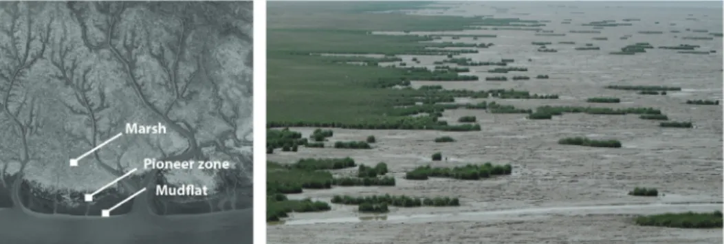
We can generally classify the state (active/expanding, stable, eroding/retreating) salt marshes reside in by looking at their margins. Active salt marshes display a threefold continuum at their outer-edge [Allen, 1995]. Starting from the salt marsh, the edge gradational passes down through a patchy zone of pioneer plants into a mudflat of similar to slightly lower slope [Allen, 2000]. This edge configuration is typical for marshes growing seaward and upward (e.g. salt marshes in the Yangtze estuary, Shanghai, China) [Xiao et al., 2009]. An intermediate near-stable case is indicated by rammed margins, that is a marsh bordered by an outer zone with moderate slope marked at right angles by wave induced scour, parallel ridges and grooves with little or no vegetation [Perillo et al., 2009]. The eroding/retreating
14 Chapter 1
case is characterized by eroding, decimetre up to meter high, cliffs [Ke and Collins, 2002]. At these edges, blocks of toppled over marsh silt at the feet of the cliff, often signify marsh retreat (e.g. marshes in the South West Delta of the Netherlands and England) [Bakker et al., 1993; Wolters et al., 2005a]. The marsh state is generally defined by the availability of sediments able to settle on the marsh surface in combination with prevailing conditions (e.g. waves, flow field, bathymetry). Sediment settling is mainly determined by the suspended sediment concentration and the hydroperiod. Previous model studies on salt marsh development showed that differential marsh growth between the sediment trapping marsh surface and the adjoined relatively exposed mudflat can increase wave impacts along the progressively steepening boundary promoting cliff formation [Ollerhead et al., 2005]. This trajectory was described as an intrinsic effect bound to happen once the marsh has built up sufficiently, nevertheless it is strongly dependent on external factors (e.g. geomorphology and hydrodynamic climate), which makes it difficult to predict [Allen, 2000].
Salt marshes are increasingly becoming targets of direct and indirect human influences. Direct influences are exerted on the salt marsh itself, mainly because of their economic importance, e.g. land reclamation for crops and settlements [Chung, 2006], recreation and fisheries and harbours/industry [Allen, 2000; El Banna and Frihy, 2009]. This for instance leads to a closer squeezing of salt marshes next to fixed (armoured) coastlines, preventing them to migrate landwards in the face of changed morphology (shipping channels) or sea level rise (i.e. coastal squeeze) [Winn et al., 2003]. Indirect influences are exerted through perturbations upstream, such as deforestation, overgrazing, road mining [Wolanski, 2007] and dam constructions [Dai et al., 2008]. Both result in altered sediment budgets [S L Yang, 1999b], changed hydrodynamic conditions and therefore altered bio-geomorphologic feedbacks [Fan et al., 2006]. This further translates in changes of their ecosystem services [Costanza et al., 1997]
Salt marshes and Geomorphology
In order to answer the question of how salt marshes are able to shape the resulting landscape configuration, literature provides two contrasting theories.
Introduction 15
Traditional literature on salt marsh development assigns a stabilizing role to salt marsh vegetation. Vegetation stabilizes and pronounces (through increased sediment trapping) features already present on tidal flats such as existing tidal channels [Allen, 2000; D’Alpaos et al., 2005]. In recent literature the potential of vegetation inducing scale dependent feedbacks to actively shape geomorphologic features and therefore influence landscape configuration was identified by [Temmerman et al., 2007; van de Koppel et al., 2012]. Through increased sedimentation within patches and increased erosion through flow routing around patches, vegetation is potentially able to initiate tidal channel erosion and therefore holds an active role shaping salt marsh geomorphology. Nevertheless, it is hypothesized that this ability is strongly linked to species properties, hydrodynamics and sediment characteristics.
Aim of the thesis
This thesis aims to enhance the mechanistic understanding of how organisms (plants) are able to shape their environment using salt marshes as model ecosystems. Specifically, I investigated how and under which circumstances interactions between plant species traits and abiotic parameters (such as hydrodynamics and sediment properties) (i.e. biogeomorphic feedbacks) possess the potential to influence the resulting landscape configuration. This examination aims to fill the existing gap in our understanding of how and when biota are able to actively influence landscape development. In order to address this question, I am utilizing a multiple scale approach, combining field manipulative experiments, flume experiments, remote sensing data and modelling approaches. First, I examine how plant traits interacting with the abiotic environment can influence the ability of species to establish and modify their habitat on a small and intermediate scale. Subsequently, I examine the ramifications of these local scale interactions on the spatial development at the landscape scale also considering the abiotic context. This not only increases our understanding of biogeomorphic feedbacks and its influence on landscape development, but also enables us to evaluate the effect of altered biotic and abiotic parameters on ecosystems functions and the landscape configuration (i.e. species invasion, sea level rise, altered sediment budgets).
16 Chapter 1
Salt marsh species and study area
Salt marsh development startson intertidal flats, which are invaded by vascular halophytic plants forming the so-called pioneer zone. We investigated two predominant pioneer species, Spartina alterniflora and
Scirpus mariqueter, in the Yangtze estuary, China (Fig. 1.1). Both species are autogenic ecosystem engineers, which induce salt marsh formation by trapping sediment and consequently increasing soil elevation. The species differ in their physical and physiological properties (Tab. 1.1). Spartina is a fast and high growing plant with stiff
above ground biomass. In comparison, Scirpus is a slower and lower growing plant with flexible aboveground material [Craft et al., 1999; Sun et al., 2001; Xiao et al., 2010]. Pioneer zones are often characterized by round patchy vegetation fragments, so-called tussocks, scattered over the mudflat, subsequently merging into salt marsh meadows incised by ramified channel systems [Allen, 2000; Temmerman et al., 2007] (Fig. 1.2). Following the pioneer zone state, salt marshes grow vertically and become high marshes dominated by more effective but less stress tolerant species such as Phragmites australis.
Study Area
It is noteworthy that our research area (i.e. salt marshes in the Yangtze estuary, Shanghai, China), is receiving enormous concentrations of suspended sediments (accretion 1 mm d-1 at marsh sites) [S L Yang and Chen, 1994], provided by the
Yangtze River (Fig. 1.1). This enables the salt marshes to grow vertically and laterally, exhibiting lateral marsh expansion rates up to 36 m y-1 and therefore
Fig. 1.1 Overview of our research area in the
Yangtze estuary, Shanghai, China. Black area with white stripes denotes salt marshes on eastern Chongming Island and the Jiuduansha Shoals.
Introduction 17
characterizing them as active/expanding salt marshes [Zhu et al., 2011]. Thanks to these conditions, are the Chinese salt marshes exceptionally well-suited locations to study the implications of biogeomorphic feedbacks loops on geomorphology. Geomorphic time scales are significantly sped up. Effects occurring within centuries at salt marshes in the Netherlands (e.g. the Westerschelde estuary with much lower concentrations of suspended sediment) can be observed at a timescale of decades at Chinese salt marshes [De Vriend et al., 2011; B Huang et al., 2008a; C Wang and Temmerman, 2013].
S. alterniflora S. mariqueter
Parameter Unit Value Ref Parameter Unit Value Ref
Plant height m 2.5 1 Plant height m 0.65 1
Stem density Stems m-2 800 2 Stem density Stems m-2 1600 2
Stem consistency Stiff 1 Stem consistency Flexible 1
Stem diameter mm 5.2 4 Max diameter mm 2.2 4
Vertical growth rate m y-1 2.5 2 Vertical growth rate m y-1 0.4 1
Lateral expansion rate m2 y-1 0.8 1 Lateral expansion rate m2 y-1 3.1 1 Critical inundation
height m 1.8 2 Critical inundation height m 2.3 2
Fig. 1.2 (left) Aerial image of a salt marsh located in the Yangtze estuary, (right) Close up view on the salt
marsh pioneer zone in Chongming Island, Yangtze estuary.
Tab. 1.1 Comparison of species traits between Spartina alterniflora and Scirpus mariqueter, grey background
18 Chapter 1
Outline of the Thesis
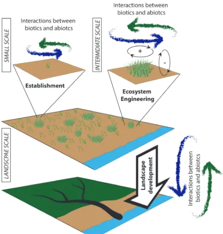
This thesis aims to increase our understanding in how organisms, interacting with the abiotic environment, are able to shape their environment on different spatial scales (Fig. 1.3). First, I investigated whether hydrodynamics and sediment properties are able to influence the survival rates of two contrasting pioneer species (Spartina alterniflora, Scirpus mariqueter) (Chapter 2). This established a link between
Fig. 1.3 A schematized view of estuarine, intertidal landscape development influenced by biogeomorphic
feedbacks across different scales; plants colonize mudflat ecosystems (upper graph), creating saltmarsh pioneer zones colonized by seedlings and tussocks (midddle graph), which finally turn into low and high marshes ramified by intertidal channels (lower graph). All these processes are influenced by interactions between biotic and abiotic properties; Courtesy of the Integration and Application Network, University of Maryland Center for Environmental Science (ian.umces.edu/symbols/).
Introduction 19
physical and physiological species properties and the abiotic conditions and their ability to influence species survival in the field. Second, via laboratory experiments I examined whether sediment properties evoke a physiological growth response within our two investigated species, and whether this growth response influences their resilience against erosion under hydrodynamic stress. Simultaneously we examined how physical plant properties are linked to their ecosystem engineering ability (Chapter 3) (Fig. 1.3). Subsequently, the impact of physical and physiological plant characteristics on the geomorphologic development during a mudflat-salt marsh transition is investigated utilizing a model simulation. I investigated the influence of mudflat bathymetry (i.e. existence of mudflat channels) on vegetation influenced landscape development utilizing a model system with constant abiotic conditions (hydrodynamics forcing and sediments) (Chapter 4). Finally, I explored whether change in plant species predominance (through species invasion) is able to influence geomorphologic features in already established salt marshes. I specifically investigated whether the invasive species Spartina alterniflora, because of its different physical and physiological properties compared to the native Scirpus mariqueter, is able, via changing biogeomorphic feedback loops, to change already established landscape features (Chapter 5). This underlines the impact of biogeomorphic feedback loops across different landscape scales and development stages.
Abiotic factors governing the
establishment and expansion of two
salt marsh plants in the Yangtze
estuary, China
C. Schwarz, T. Ysebaert, ZC. Zhu, LQ. Zhang, T. Bouma, P. M. J.
Herman
22 Chapter 2
Abstract
The survival and establishment of salt marsh plant species is mainly driven by abiotic parameters. These factors can also significantly affect the outcome of competitive interactions between plant species. In this study we identify the effect of abiotic factors such as waves, currents, and sediment properties on plant establishment and development in the pioneer zone at Chongming Island, Yangtze estuary. Different propagules (seedlings, rhizome fragments, complete tussocks) of the species Spartina alterniflora and Scirpus mariqueter were planted at sites differing in current velocity, wave height, and sediment composition. Survival was strongly size-dependent, with very few of the smallest stage (seedlings) surviving. Survival of the native species S. mariqueter was higher than that of the invasive species S. alterniflora. Survival and lateral expansion rate of the experimental plants was highest at the site with lowest tidal currents, and lowest at a strongly wave-dominated site. We suggest that competitive interactions between the species are governed by plant-abiotic interactions influenced by both plant morphology and growth rate. Further we discuss the implications of these findings on the large-scale patterns of vegetation at this salt marsh.
Abiotic Factors 23
Introduction
Increasing human mobility has caused species introductions in previously unconnected areas [Vitousek et al., 1997]. Over the last decade, there has been a growing concern that invasive species can have a major impact on biodiversity and ecosystem functioning. Understanding the spread of invasive species becomes more and more important for wetland conservation and management [Ruiz and Carlton, 2003]. One of the most examined invasive species in intertidal coastal wetlands is
Spartina alterniflora (Poaceae). Spartina alterniflora is a perennial rhizomatous cord grass native to the coasts of North America [Simenstad and Thom, 1995; Teal, 1985]. It is a strong ecosystem engineer [Crooks, 2002], which similar to other
Spartina species reduces erosion and enhances sediment accretion [Bouma et al., 2009a; van Hulzen et al., 2007]. This ability to accrete sediment is the main reason this species was introduced worldwide and has resulted in rapid expansion and invasion in many wetland ecosystems [Balletto et al., 2005; J Callaway and Josselyn, 1992; B Li et al., 2009]. The ability of Spartina species to modify its habitat by accumulating sediment is mainly due to its morphology [Bouma et al., 2005b; van Hulzen et al., 2007]. The aboveground parts of S. alterniflora can reach heights of 1–3 m, consisting of stiff stems with hard leaves of 30-90 cm lengths. Belowground,
S. alterniflora forms extensive rhizome networks in the upper 10–30 cm of the soil. Rhizomes are also used as clonal reproduction organs. At the end of the growing season (April to November, China) most of the ramets die off, but leave behind large amounts of standing dead litter with a low decomposition rate [Liao et al., 2008; Q Wang et al., 2006]. The mechanism by which S. alterniflora spreads and outcompetes native vegetation is however not always clear.
Spartina alterniflora was originally introduced in eastern China in 1979 [An et al., 2007; B Li et al., 2009], and first found in salt marshes of the Yangtze estuary in the 1990s [H M Huang and Zhang, 2007]. In 1995, it was first observed on the salt marshes of eastern Chongming Island, one of the main islands in the mouth of the Yangtze estuary. It was suspected to have arrived through natural dispersal from populations in Jiangsu province [Chen et al., 2004; B Li et al., 2009]. In 2001
24 Chapter 2
within only one decade it became the dominant plant species in the salt marsh pioneer zone across the whole estuary [Chen et al., 2004; H M Huang et al., 2008b; B Li et al., 2009]. This was achieved mainly through outcompeting the indigenous species Phragmites australis in the more brackish part of the estuary and especially
Scirpus mariqueter (Cyperaceae) in the areas with higher salinity. Scirpus mariqueter
is a long-lived rhizomatous corm forming plant that inhabits the pioneer zone of salt marshes in the Yangtze estuary [Sun et al., 2001; M Yang et al., 2009]. Reproduction of S. mariqueter occurs sexually through seeds and asexually through corms. The aboveground shoots are usually 10 to 80 cm high and composed of two leaves. The growing season lasts from May to October, ending with the dying-off of all aboveground parts, while the belowground parts overwinter [C H Wang et al., 2009]. Spartina alterniflora locally excluded S. mariqueter, forming dense monocultures, but in some areas Spartina – Scirpus mixtures do occur. Where both species co-occur, their different growth forms become obvious, with S. alterniflora
being much taller and more stiff compared to S. mariqueter.
Previous studies in the Yangtze estuary showed that the observed expansion patterns of S. alterniflora on Chongming island cannot be explained by sexual reproduction (seed dynamics) [Deng et al., 2009; Xiao et al., 2009], range expansion behavior [Xiao et al., 2010], or competitive exclusion of its native competitor (Scirpus mariqueter) [B Li et al., 2009] alone. In the pioneer zone, none of these characteristics points to S. alterniflora as the superior species bound to win the competition. Other studies indicate that survival and establishment of salt marsh plants in the pioneer zone also depends on the interaction between hydrodynamic energy from currents and waves with the characteristics of the plants (size of the propagule, stiffness of the growth form) and with other abiotic characteristics, such as sediment composition [Bouma et al., 2005b; van Hulzen et al., 2007; van Wesenbeeck et al., 2008a]. The importance of such feedbacks in the displacement of S. mariqueter by S. alterniflora
have not yet been investigated. Compared to most estuaries around the world, the present study site is unique in that it is has a very high sediment load delivered from the Yangtze-river, leading to exceptionally high accretion rates at the marsh (4–14 cm year-1) [S L Yang, 1999c]. Hence, vegetation-geomorphology feedbacks may
be expected to have strong impacts on short time spans, making this a potentially important factor in understanding the displacement of S. mariqueter by S. alterniflora.
Abiotic Factors 25
In this study, we investigate the interaction between hydrodynamics and plant characteristics as a mechanism to explain the rapid expansion of S. alterniflora at the expense of S. mariqueter. We study these interactions by quantifying the survival of S. alterniflora and S. mariqueter transplants of three different size classes at hydrodynamic contrasting pioneer zones of eastern Chongming Island. We varied the size of propagules in transplanting experiments, from single small seedlings to clonal fragments and tussocks of up to 10 cm diameter. Furthermore, we chose experimental field sites differing in current and wave stress. Its spatial orientation, with tidal and salt-water dominance in the north and river and wave dominance in the south leads to gradients in sediment properties, hydrodynamics, and salinity [Chen et al., 2004] over relatively short distances. This experimental design enables us to test the influence of various abiotic factors on the establishment, survival, and expansion of these salt marsh species.
Fig. 2.1 Overview of the research area including experimental sites in the Chongming Dongtan Nature
26 Chapter 2
Methods
Field site
The Yangtze River, originating on the Tibetan plateau and flowing out into the East China Sea, is the longest river in China and one of the largest rivers in the world. Located at its mouth is the Yangtze estuary, a meso-tidal estuary with semidiurnal tides, covering large areas of Shanghai and Jiangsu province. The estuary’s upper boundary is located at Datong, 624 km upstream. Its mouth is located at the shallow mouth bars in the East China Sea. The adjacent submerged delta is the major area of sedimentation, fed by silt transported by the Yangtze River [Z Gao and Zhang, 2006; Liu et al., 2010; Mikhailov et al., 2001]. There are several alluvial islands existing in the Yangtze estuary, Chongming Island being the oldest and largest Island [B Li et al., 2009] (Fig. 2.1).
It has a northern sub-tropical monsoon climate, with an average humidity of 82%. The average summer temperature is 26 ˚C. The average winter temperature is 15.3 ˚C. Annual precipitation is 1022 mm on average, 60% of which falls in the months May to September [Xiao et al., 2009]. A speciality of the climate in the Yangtze estuary is the so-called Mei-yu period, the main annual rainy period. It lasts for approximately three weeks and contains most of the heavy rain events of the year, accounting for on average 20% (217 mm) of the yearly precipitation. The beginning and end of the Mei-yu period is subject to fluctuations from year to year. Its onset can vary from late May to mid July and its end can vary from mid June to early August [Qin and Duan, 1992].
Establishment and Lateral expansion:
To investigate the influence of various abiotic parameters (sediment properties, wave stress, and current stress) on plant establishment, planting experiments with the two species at three different locations were conducted. The sites were chosen according to differences in hydrodynamic properties (wave and current magnitudes), sediment composition (median grain size (d50), sediment cohesiveness) and present plant community. Field site observations showed that within the large-scale plant
Abiotic Factors 27
community patterns (Spartina dominating the northern part, Scirpus the southern part) [C H Wang et al., 2010a] the pioneer zones showed even more variation. Three types of growing fronts within the pioneer zone could be identified: (1) Spartina
front (SP), (2) mixed Spartina and Scirpus front (SPSC), and (3) Scirpus front (SC). These different fronts also show different seed bank characteristics and growth velocity towards the seaward boundary [Xiao et al., 2010]. Transplants of three different biomass classes of the two plant species were planted in May 2010 on the mudflat adjacent to the pioneer zone at three different locations, each representing one type of observed vegetation front. The biomass classes included seedlings, small clonal fragments (further referred to as rhizomes), and large clonal fragments (further referred to as tussocks). The three biomass sizes are a good representation of natural ways of recruitment for these two species [Ranwell, 1964; Sun et al., 2001; van Wesenbeeck et al., 2008a]. Seedlings represent natural sexual reproduction. Rhizomes or tillers can break off and get dispersed [Ranwell, 1964] and then act as a dispersal unit. Finally, bigger units can also act as dispersal agents, spreading during times of high hydrodynamic energy, (e.g., during storms with high waves) justifying our third class of dispersal unit. The distance from the marsh was chosen according to a previously available elevation survey, guaranteeing that the dispersal units would receive the same amount of inundation stress. Note, however, that in practice some differences in elevation existed between the three locations, presumably as a consequence of deposition between the time of elevation measurements in 2010 and the establishment of the experimental units.
Seedlings, rhizomes and tussocks were taken from one single area in the case of
Scirpus mariqueter. In case of Spartina alterniflora, due to logistic constraints, dispersal units were taken from two areas comparable in terms of relative distance to the marsh edge, coverage, and inundation stress. The seedlings selected had a maximum height of 10 cm, an already developed primary root system but no identifiable rhizome parts. Rhizome fragments had a plant height of 10–15 cm with already developed roots holding a rhizome of approx. 10–15 cm length with one to three green stems. Tussocks were defined as larger clonal fragments of 20x20 cm dimension, extracted from existing vegetation in the pioneer zone. At sites SP and SPSC, both species were planted. This was not possible, however, at site SC, where the experiment would risk introducing Spartina in an area where it does not yet occur. At the sites
28 Chapter 2
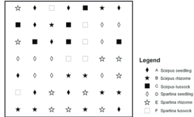
SP and SPSC, the three dispersal classes were planted in a randomized block design (7x7 grid) with three replicate blocks parallel to the coastline (see Fig. 2.2). The minimum inter-distance between the dispersal units was chosen to be 3 m. These inter-distances were chosen according to existing literature on lateral
expansion velocity, to keep the mutual disturbance to a minimum (2.0–2.70 m.yr-1
lateral expansion of S. alterniflora within one growth season [Xiao et al., 2010]). Each block (containing 49 dispersal units) consisted of 9 seedlings, 10 rhizomes, and 6 tussocks for Spartina alterniflora and 9 seedlings, 9 rhizomes, and 6 tussocks for Scirpus mariqueter. For practical reasons, only 6 tussock fragments per block were planted, while the other stages had higher representation. At the SC site, 14 seedlings, 12 rhizomes, and 10 tussocks of S. mariqueter were planted on a random 6x6 grid with two replicate blocks at three distances to the marsh edge. Because of the low survival rates and similar survival curves (statistically not different) the two replicates at three marsh distances were pooled and further regarded as one observational site.
After planting, presence/absence of the different planted units was measured on a monthly bases and lateral expansion was measured at the beginning and the end of the observation period (5 months). Survival data was analysed in Matlab® performing log-rank tests using Kaplan-Meier estimates of the survival functions [Gardillo, 2008].
Abiotic parameters:
We measured sediment characteristics and hydrodynamic forcing (i.e., tidal currents, wave action) to describe the environmental factors driving species survival and expansion. Sediment samples (5 replicates) were taken of the top 3 cm layer at
Abiotic Factors 29
each site and analysed for its grain size distribution, using a Beckman-Coulter® LS 13320 particle size analyser. The resulting data was analysed in Matlab® using Ternary plots [Waite, 2006].
Currents and waves were measured over a spring-neap cycle in the Mei-yu period (9th of July – 20th of July) parallel to the three different locations. Current
parameters were assessed using an Aquadopp® HR 2Mhz current profiler (downward looking 60 cm above the bottom surface, minimum cell size= 3 cm) at the SP-site, an Aquadopp® HR 1Mhz current profiler (downward looking 60cm above the bottom surface, minimum cell size= 3 cm) at the SPSC-site and a Sontek® XR current profiler (upward looking, minimum cell size= 20 cm) at the SC-site. Over the same period, wave parameters were measured using three Seabird® SBE 26plus wave sensors deployed directly on the marsh surface. All measurements were filtered according to signal quality thresholds suggested by the manufacturer and by previous literature in Matlab® [Cheng et al., 1999; Horstman et al., 2010]. Wave energy was computed using the manufacturer’s software of the SBE26plus, calculated via the spectral wave density function. For statistical analysis, the non-parametric Kruskal-Wallis test was used because the data was non-normally distributed (significance level; 0.05).
30 Chapter 2
Results
Survival:
Bigger dispersal units (especially tussocks) showed higher survival rates at all sites, as demonstrated by the survival curves (Fig. 2.3). Log-rank comparisons show that tussocks have significantly higher survival than all other dispersal units. The highest survival rates can be observed at the SPSC site, where all dispersal units of Scirpus and also the tussock dispersal units of Spartina exhibit the highest survival rates. Survival rates of all Scirpus mariqueter dispersal units were significantly higher than the corresponding units of Spartina alterniflora at the
field sites SP and SPSC (Fig. 2.3), except for seeds at site SP (seedlings of both species had disappeared during the first month) and tussocks at site SPSC where survival of both species was very high. No Spartina seedlings survived the first observational time step. Scirpus, which is the only species we were able to plant at all three locations, performed best at the SPSC site and worst at the SC site.
Fig. 2.3 Survival curves of Spartina and Scirpus dispersal units
at sites SP, SPSC and SC (the latter only having Scirpus stages). Mean and standard error of the pooled replicates are shown.
Abiotic Factors 31
Lateral expansion:
The lateral expansion rates showed a clear difference between species and sites, with a much larger lateral expansion of both species at the SPSC site compared to the SP site and with
Scirpus expanding at a faster rate than
Spartina (Fig. 2.4). Lateral expansion at the SC site was estimated as zero, since the low survival rate did not allow to measure any lateral expansion. Fig. 2.5 illustrates the large differences in lateral expansion between the sites.
Fig. 2.5 Comparison between lateral expansion: (a) Spartina at the SP site (8.Oct.2010), (b) Scirpus at the
SP site (8.Oct.2010), (c) Spartina at the SPSC site(9.Oct.2010), (d) Scirpus at the SPSC site (9.Oct.2010);
Fig. 2.4 Lateral expansion of tussock
diameters 5 months after planting, SC site not shown since the low survival did not allow to measure lateral expansion rates, mean and standard error of the measure replicates polled per site are shown
32 Chapter 2
Sediment properties:
Analysis of the sediment samples taken at the three sites, showed a large difference in grain size distribution between the more muddy northern part (SP, SPSC; d50=6.46 ± 0.24 and 8.83 ± 0.66 μm, respectively) and the more sandy southern part of the eastern Chongming salt marsh (SC; d50=63.8 ± 2.81 μm) (Fig. 2.6). Clay content was very low at the SC site; the sediment was clearly non-cohesive. At SPSC and SP sites, clay content was higher and it exceeded the threshold level of 7.5%, which delineates cohesive from non-cohesive sediments according to [van Ledden et al., 2004].
Fig. 2.6 Shepard-Ternary-Plot showing sand-silt-clay ratios at the experimental sites. Red line delineates
cohesive and non-cohesive sediments according to a critical clay content of 7.5 %.
Abiotic Factors 33
Hydrodynamic properties
Water levels showed tidal ranges typical for a meso-tidal estuarine system (Fig. 2.7). The two northern sites showed similar maximum inundation heights (SP, 1.69 m and SPSC, 1.53 m), whereas the southern site showed a clearly higher inundation height (SC, maximum 2.2 m).
Currents
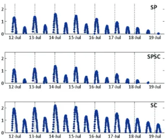
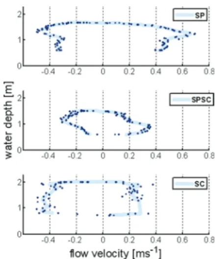
Comparison of current velocities showed that during spring tide, maximum current velocities during ebb and flood flow at the SP site (0.72 ms-1) were higher than
at the SPSC (0.52 ms-1) and SC site (0.62
ms-1) (Fig. 2.8–2.9). The box plots in Fig.
2.9 show a similar distribution between the flood current velocities of site SP and SC, whereas the SPSC exhibits a clearly lower maximum velocity. They further show that tidal currents tend to be flood-dominated at site SP, and ebb-dominated at the other two sites, in accordance with the pattern shown in Fig. 2.8.
Fig. 2.8 Current velocity measurements at highest
high tide; negative values represent the incoming tide, positive values the outgoing tide; dark blue points represent measured velocity time-points; thick light blue line represents the moving average
Fig. 2.9 Current velocity distribution over measured spring-neap cycle, separated in ebb and flood
velocities per site, The central red mark represents the median; the edges of the boxes are the 25th and 75th percentiles; whiskers are the most extreme data points not considered as outliers, and outliers are plotted individually
34 Chapter 2
Waves
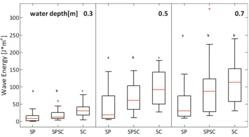
A comparison between the wave characteristics observed at the three sites showed significant differences in wave heights (not shown) and wave energy from the northern to the southern parts of the salt marsh (Fig. 2.10). Mean significant wave heights at 0.3, 0.5, and 0.7 m water levels ranged from 0.11, 0.22, and 0.24 m at SP site, to 0.16, 0.31, and 0.35 m at SPSC site, to 0.21, 0.36, and 0.38 m at SC site. Wave energy (Fig. 2.10) and wave height showed an increasing trend from north to south. This trend was consistent when comparing wave characteristics at different water levels (0.3, 0.5, 0.7 m). The observed succession in wave stress can be explained through the predominant southeast wind direction within our observational period and the spatial arrangement of our planting sites.
Fig. 2.10 Comparison of wave energy at three different water levels (0.3, 0.5, 0.7m) between the three
different experimental sites, the central red mark represents the median; the edges of the box are the 25th and 75th percentiles; whiskers are the most extreme data points not considered outliers, and outliers are plotted individually. Different lowercase letters denote significant differences between species
Abiotic Factors 35
Discussion
Gradients in abiotics and plant survival:
The three experimental locations along a north-south gradient of the eastern Chongming Island showed clear differences in hydrodynamic conditions and grain size distributions. Compared to the SP site, the SPSC site had lower currents but higher waves. Both sites have fine cohesive sediments, but the SP site has the highest clay content and overall the finest sediment composition. The SC site in the south was characterized by the highest waves. Currents at this site were intermediate in strength between the SP and SPSC sites. It seems that the coarseness of the sediment correlates much better with wave height than current velocity. Sediments are coarser in the sequence SP, SPSC, SC; wave height also increases in this sequence. The increase in grain size in southerly direction on eastern Chongming Island was also previously suggested by [S L Yang et al., 2008].
The survival of plant dispersal units followed a different sequence. Survival of all
Scirpus stages was lowest at SC, where even tussocks did not survive the experimental period. However, the overall survival seemed to be higher at SPSC than at SP. The difference was significant over the entire period for Spartina tussocks, but not for the other stages. However, at SPSC there seems to be a difference between the first month of observation when mortality was high and later, when minimal mortality was observed over the different species and stages (Fig. 2.3). This contrasts with station SP, where mortality of smaller stages (seedlings and rhizomes) continued over summer. It is possible that the higher waves measured during the Mei-yu period at SPSC were not present during the whole summer, whereas the difference in tidal currents presumably is much more constant. However, wind statistics for the Shanghai area show very little seasonal variation in wind speed. Wind direction switches from predominantly NW during winter, to predominantly SE during summer. The transition is in March and October (www.windfinder.com). Over the growing season, winds are relatively predictable and similar to the winds measured during our study period. Also judging from lateral expansion rates, growth conditions at SPSC seem to be better than elsewhere. Presumably the lower tidal currents at
36 Chapter 2
this station than at the other stations have more effect on growth conditions than waves, even if waves seem to correlate better with the sediment structure.
Size thresholds to plant survival:
Our results indicate the existence of a size threshold influencing the survival functions of the dispersal units. This is evident through the higher survival rates of the bigger dispersal units (especially tussocks) at all experimental sites (Fig. 2.3) Seedlings of both Spartina alterniflora and Scirpus mariqueter showed almost no survival in our experiment. Possibly in this system seeds are not the main dispersal unit, as is also suggested by the discrepancy between seed production and soil seed bank [Xiao et al., 2009]. This is probably caused by hydrodynamic disturbances influencing the upper sediment layers and therefore circumventing seed settlement and burial. Likely candidates for main dispersal units are detached rhizome fragments, which have a greater chance to develop a sufficient root network before the aboveground parts start emerging. However, an alternative explanation for the low survival of seedlings is the relatively late planting of the dispersal units in May, which is already at the beginning of the Mei-yu period. The time may have been too short for the root network to develop sufficient anchorage to the soil, keeping in mind S. mariqueter’s comparatively late germination start at the beginning of May [C H Wang et al., 2009]. This explanation would imply that only early germinating seedlings would have a chance of survival. This hypothesis is strengthened by the known early germination start of S. alterniflora at the beginning of April [C H Wang et al., 2009; Xiao et al., 2010] and the measured higher survivorship of Spartina
seedlings (60% to 75.3%) at SP and SPSC sites [Zhu et al., 2011].
The existence of a size threshold influencing plant survival in salt marsh pioneer zones is in agreement with previous studies on salt marsh dynamics [van Wesenbeeck et al., 2008a]. It implies that young stages have a window of extreme vulnerability where physical disturbance may easily inhibit survival. All other factors kept equal, rapid growers have an advantage under such conditions, since they will be the first to escape this window of vulnerability. However, apart from growth rate, the inherent vulnerability of the seedling may also be important. In our experiment, the only seedlings surviving are 20% of Scirpus seedlings at the SPSC site. But at the SP site
Abiotic Factors 37
the Scirpus seedlings also exhibit a (non-significant) tendency of a higher survival than the Spartina seedlings. It is possible that the growth form of Scirpus, with more flexible plants, makes the seedlings less vulnerable to erosion [Bouma et al., 2009a].
Unravelling the displacement of
S. mariqueter
by
S. alterniflora
:
With the experimental results showing better survival of Scirpus, even at the site where Spartina dominates the pioneer zone, it is not easy to explain the occurrence of both species in nature. One explanation could be that Spartina, which germinates earlier than Scirpus, has larger seedlings by the time of the worsening of weather conditions in the Mei-yu period and therefore profits from size-dependent survival [C H Wang et al., 2009]. The combination of Spartina’s earlier start of its growing season, together with its faster growth rate [Q Wang et al., 2006], the higher tolerance to inundation and salinity stress [C H Wang et al., 2010a] and the higher sediment trapping efficiency [H Li and Yang, 2009], might explain the observed dominance of S. alterniflora throughout the Yangtze estuary and other parts along the Chinese coast.
The fact that Scirpus exhibited higher survival in the pioneer zone than Spartina
at all sites, but is still not able to outcompete this strong ecosystem engineer at some sites, might also be explained through a facilitation effect of Scirpus. Although better able to cope with abiotic stress at initial settlement, the species does not form as dense a grass mat as Spartina does (Fig. 2.4). Presumably, its tussocks are relatively easily invaded by the taller, faster growing Spartina. Facilitation by a pioneer species that makes way for the dominant competitor, which itself is restricted by physical conditions, is a well-known pattern in salt marshes [Castellanos et al., 1994].
The higher dominance of Scirpus at the more southern stations could be related to the higher wave stress at these locations. The stiff plant parts of Spartina are exposed to substantial drag in strong waves [Mullarney and Henderson, 2010], which is a disadvantage compared to the lower drag experienced by more flexible species like Scirpus [Bouma et al., 2005b]. The absence of S. alterniflora in the southern part of Chongming Island might in addition also be a consequence of the salinity gradient (north 5 g/kg soil; south 0.5 g/kg soil) [Y Li et al., 2010b] and extensive buffalo grazing in this area [B Huang et al., 2008a].
38 Chapter 2
Conclusion
Our findings suggest that waves and currents may differently influence plants and sediments. Moreover, competitive interactions either through a facilitation strategy or via size-dependent survival and differential germination patterns, are more complicated than simple differences in survival of abiotic stress, setting previous studies on abiotic interactions into new perspectives [C H Wang et al., 2010a]. Further, our results question the possibility of Spartina’s establishment in the southern part of Chongming Island, where Spartina in spite of its stronger ecosystem engineering capability, still did not succeed in outcompeting Scirpus [R Z Wang et al., 2010b]. We suggest that plant traits (competitive strength, ecosystem engineering capability) and abiotic interaction patterns always have to be thoroughly considered before being able to determine their degree of influence on plant zonation patterns and competitive outcomes. This underlines the importance of an integrated approach utilizing a combination of correlative and experimental studies to unravel complex biotic-abiotic interactions.
Plant traits and sediment
characteristics influencing species
establishment
42 Chapter 3
Abstract
The salt marsh plants Spartina alterniflora and Scirpus mariqueter are dominant pioneer species found on salt marshes in the Yangtze estuary, China. They differ in physical (e.g. stiffness) and physiological (e.g. stress tolerance) plant properties, potentially influencing their ability to establish in different habitats and to engineer their environment through biogeomorphic feedbacks. In this study we use laboratory experiments to test seedling resilience of these two species against erosion under current stress in different sediment types representing the range in their natural habitat. We further investigate in flume experiments how their physical plant properties (i.e. stiffness) influence their engineering ability under different hydrodynamic conditions (i.e. water level). The experiments were utilized to investigate how interactions between abiotic and biotic parameters influence establishment thresholds and the ability of the two species to engineer their environment. Our results indicate that not only physical plant properties such as stiffness but also physiological plant properties such as adapted root morphology due to sediment properties in combination with abiotic factors (sediment and hydrodynamics) exert a major control on species establishment thresholds. We further establish a link between ecosystem engineering ability and physical plant properties (i.e. stiffness) and show its influence on species establishment. Finally we use our insights about interactions between plants, sediment and hydrodynamics to explain species expansion trajectories in their natural habitat. The upscaling of our results proposes impacts of biogeomorphic feedbacks (i.e. ecosystem engineering) on landscape development adding important information for marsh restoration and management.
Plant Traits 43
Introduction
The field of biogeomorphology investigates the interaction between ecology and geomorphology and its impact on landscape development [Hupp et al., 1995; Phillips, 1995; Stallins, 2006]. Within the framework of biogeomorphology, ecosystem engineering is a key concept describing the impacts of organisms on their immediate surroundings. Organisms (e.g. plants) can, through altering their immediate surroundings, invoke positive feedbacks improving living conditions for themselves and potentially associated species [Jones et al., 1994; Mullan Crain and Bertness, 2006]. Biogeomorphic feedbacks loops (i.e. the interaction between biotic and abiotic ecosystem processes) shape a variety of coastal and inland habitats, such as river ecosystems or salt marshes incised by ramified tidal channel networks [Tal and Paola, 2007; Temmerman et al., 2007]. Ecosystem engineering introduces spatial heterogeneity and affects ecosystem services, such as nursery habitats for fish and birds, recreation areas, sediment and nutrient sinks and coastal protection [Borsje et al., 2011; Costanza et al., 1997; Gedan et al., 2011; Ma et al., 2007].
Coastal ecosystems, for instance salt marshes, are highly stressed environments. Currents, waves, salinity, soil moisture and sediment accretion/erosion create stress gradients along which stress dependent plant species zonation develops [Marani et al., 2013; Moffett et al., 2010]. These zones, often consisting of a single plant species [C H Wang et al., 2010a], can be used as simplified systems to study biogeomorphic feedback loops and to identify specific factors influencing them.
Seedling establishment is a crucial step in dynamic coastal ecosystems (e.g. salt marshes, mangroves) to enable vegetation succession. Previous studies focused on the impact of hydrodynamics (i.e. hydroperiod, currents and waves), salinity, temperature and soil moisture on seedling establishment [Corenblit et al., 2007; Patterson et al., 1997]. Subsequently literature has shown that initial seedling settlement and therefore plant species establishment is strongly dependent on interactions between sediment dynamics and hydrodynamic conditions (i.e. currents, waves). It was specifically shown that settlement of seedlings on mudflats can only take place during periods of low hydrodynamic stress, called windows of opportunity [Balke et al., 2011]. After this bottleneck was passed temporarily established seedlings were shown to be still
44 Chapter 3
vulnerable to sediment dynamics (accretion/erosion) and hydrodynamics (waves). The magnitude of this vulnerability was shown to be strongly dependent on species specific plant traits (physiological plant properties such as growth velocity) [Balke et al., 2013]. These results suggest that also sediment properties might influence this relationship, because both plant growth rate and plant-hydrodynamics interactions may depend on sediment type.
Once established, salt marsh plants tend to form round patchy vegetation units, so called tussocks, scattered over the mudflat [Allen, 2000; Castellanos et al., 1994]. At this development stage (intermediate scale) the interaction between plants traits and abiotic factors (such as currents and sediment properties) continues to exert a major control on the plant’s ability to permanently establish and to ecosystem engineer its environment [Schwarz et al., 2011; van Wesenbeeck et al., 2008a]. Literature describes the outcome of ecosystem engineering to be dependent on the abiotic setting (i.e. currents and sediments), species traits and the considered scale, further referred to as context dependency [Jones et al., 2010]. The context dependent outcome of ecosystem engineering at different scales was shown through scale dependent feedbacks observed at established plant tussocks. Tussocks exhibited a small-scale positive feedback (improving living conditions) via promoted accretion (through reduced hydrodynamics) within their patches. This was in contrast to a large-scale negative feedback (deteriorating living conditions) via induced erosion (i.e. scouring, through flow routing) at their edges [van Wesenbeeck et al., 2008b]. Recent studies on context dependency showed that physical plant traits (such as stem stiffness) have a strong influence on an organism’s ability to ecosystem engineer its surroundings. Stem stiffness is an important parameter for the interaction between plants and currents. Stiffer plants exhibit a higher ecosystem engineering ability than flexible ones [Bouma et al., 2010; Bouma et al., 2009b], due to a stronger dampening of hydrodynamic energy. This higher ecosystem engineering ability comes at a cost. High ecosystem engineering ability entails higher drag forces exerted on the plant and its root network and therefore increases its probability of being uprooted [Bouma et al., 2005b]. These studies focused on two aspects of interactions between plant traits and hydrodynamics; their direct effect on plant structures (increased drag and consequently uprooting probability), and their influence on the small-scale positive feedbacks i.e. increased sedimentation between stems due to reduced hydrodynamic
Plant Traits 45
stress (promoted accretion) [Bouma et al., 2005b; Bouma et al., 2009b; Nepf, 1999]. It can be expected that this relation is also context dependent, but this has not been investigated so far.
In this study we first investigate how the combination of different plant traits and different sediment properties (Mud, most cohesive; MuddySand; SandyMud; Sand, most non-cohesive) under hydrodynamic stress is able to influence plant survival. We measured the influence of bottom sediment properties on the ability of plants to withstand erosion under current stress. We subsequently linked this ability to withstand erosion to plant traits such as stem stiffness and plant growth response to different sediment types. We used two contrasting salt marsh species in our experiments. The stiff Spartina alterniflora (further referred to as Spartina) and the flexible Scirpus mariqueter (further referred to as Scirpus) are grown on different sediment types, representing the sediment range encountered in their natural habitat (i.e. salt marshes in the Yangtze estuary, China). The two species differ in physical properties of the aboveground material (stiffness, maximum plant height, maximum stem diameter), the belowground material (root network organization) and in physiological properties such as growth velocity and stress tolerance (e.g. salinity) [He et al., 2012; Sun et al., 2001].
After investigating the impact of biotic-abiotic interactions on seedling establishment, we explore the influence of biotic-abiotic interactions (i.e. biogeomorphic feedbacks) on the ecosystem engineering ability of established seedlings (i.e. tussocks, intermediate scale). We are specifically investigating the influence of plant traits (stiffness) on large-scale negative feedbacks exerted by established tussocks, namely induced scour at their edges, under different abiotic conditions of water level and current flow. For this purpose we conducted a flume experiment with our two contrasting plant species (Scirpus and Spartina), inducing sediment movement (local scour) through current stress adjacent to plant patches at two different inundation stages (emerged, submerged vegetation) utilizing the most non-cohesive sediment type of the seedling experiment (Sand).
Finally we use the insights of our laboratory experiments on seedlings and tussocks in combination with hydrodynamic field measurements to elucidate species establishment and expansion patterns in their natural habitat.
46 Chapter 3
Methods
Field characterization
Spartina and Scirpus are the most abundant halophytes present on salt marshes in the Yangtze estuary, China. They differ in physical aboveground and belowground properties (e.g. Spartina: stiff, max shoot height: 3m, Scirpus: flexible, max shoot height: 0.8m), growth season (Spartina: May to October, Scirpus: April to November), stress tolerance and competitive strength [He et al., 2012; B Li et al., 2009; Schwarz et al., 2011; Sun et al., 2001]. Scirpus is endemic to the Yangtze estuary and used to be the most abundant species observed in pioneer zones and low marshes. Spartina
was first found in the Yangtze estuary in 1990 and thereafter started to outcompete the endemic species [H M Huang and Zhang, 2007]. On Chongming Island, the biggest Island in the Yangtze Estuary China (31.6619°N, 121.4780°E), Spartina was planted in 2001 in the northern part of Eastern Chongming. Thereafter, it began to spread across existing Scirpus marshes accounting for 50% coverage of vegetated intertidal area in 2005 [Q Wang et al., 2006]. The predominant spreading direction of Spartina on Chongming Island was northwards (characterized by muddy, cohesive sediment) whereas only limited spreading from the planted sites towards the south (characterized by sandy, non-cohesive sediment) could be detected [B Li et al., 2009; R Z Wang et al., 2010b].
Critical vertical erosion threshold experiment
Seedling Growth ConditionsSeeds from Spartina and Scirpus were collected from salt marshes on Chongming Island, Yangtze estuary, China and brought to the Netherlands. They were germinated and cultivated in a climate room, which was held at 25°C and provided with an average of 12h d-1 of 550μmol m-2s-1 photosynthetic active radiation (PAR).
Seedlings were planted at 1cm depth below sediment surface in four different sediment types in individual PVC pipes (160mm height and 120mm diameter), with open bottoms and placed in large polyethylene bags. The composition of the four different sediment types was chosen following sediments types present on the
Plant Traits 47
pioneer zones (i.e. mud flat – salt marsh transition) in the Yangtze estuary. Artificial Silt, Sand and Clay (Sibelco benelux®) with a determined grain size were combined with a nutrient mix (osmocote®) to mimic 3 types of natural sediments (Mud, MuddySand, SandyMud). The properties of these mixed sediment types were; Mud (Sand: Silt: Clay - 0:60:40) with a d50 of 3.5 microns, MuddySand (Sand: Silt: Clay - 37:52:11) with a d50 of 35.6 microns and SandyMud (Sand:Silt:Clay - 49:43.5:7.5) with a d50 of 60.3 microns. The fourth sediment type (Sand) was taken from a mudflat in the Oosterschelde estuary (The Netherlands) with the properties Sand (Sand: Silt: Clay - 96:3:1) with a d50 of 184.9 microns, also subsequently mixed with osmocote® to ensure a surplus of nutrients. Fig. 3.1 shows the positions of the chosen sediment mixtures in comparison to sediment samples taken in the pioneer zones in the Yangtze estuary. The sediments were all mixed with the same volume of water and kept waterlogged throughout the experiment. The duration of the growth phase was chosen to be 33 days, representing the average time available for seedlings before the onset of the disturbed period in the Yangtze estuary [Schwarz et al., 2011]. During their growth phase all treatments experienced a semidiurnal 1.5h flooding, simulating tidal inundation on a tidal flat.
Fig. 3.1: Composition (Sand:Silt:Clay) of our chosen sediment mixtures(big Symbols) to sediment
samples from salt marsh pioneers zones at various locations in the Yangtze estuary(little Symbols), the black horizontal line indicates the empirical cohesive/non-cohesive boundary [van Ledden et al., 2004]
48 Chapter 3
Flume experiment and seedling erosion
The NIOZ flume consists of a 17.5 m long and 0.6 m wide oval racetrack that can produce currents and waves [Balke et al., 2011; Bouma et al., 2009a]. At the double bottom test section, the cut PVC pipes filled with sediment were inserted plane with the flume bed, leaving only the seedling exposed [Balke et al., 2011; Balke et al., 2013]. No significant scouring was observed. Flume water depth was maintained at 32cm. A constant current of 0.35 m s-1, representing the averaged
field situation [Schwarz et al., 2011], was applied with a conveyor belt. Bed shear stress due to current flow was calculated by the apparent roughness height for the flume bottom in combination with velocity profile measurements (Nortek Vectrino) [van Rijn, 1993]. Equations are stated in the appendix.
The pots were slowly placed into the test section of the flume and current stress was applied (0.35 m s-1 equivalent to a bottom shear stress of 0.38 N m-2). For
seedlings resisting this bottom shear stress the critical vertical erosion threshold was determined, by defining the amount of sediment that needed to be removed from around the seedling to topple it over. The amount of critical erosion for seedling toppling over was determined by raising the sediment incrementally through placing PVC discs of 1 to 3 mm thickness underneath the pipe. After each incremental step, sediment at the top of the PVC pipe was gently removed using a water jet to keep the sediment level with the flume bottom. Subsequently, seedlings were put back into the flume and exposed to the same current stress (0.38 N m-2, see above). This cycle
was repeated until toppling over occurred. In a field situation toppling over would be followed by burial and therefore death of the seedling. For Scirpus, which also grew vegetative ramets, erosion cycles were continued until also the ramets toppled over. After toppling over, seedlings were carefully removed from the sediment and their biomass was measured. We separated above- and belowground biomass and determined the dry weight (drying until constant weight at 80°C). For belowground biomass three subcategories were chosen: 0 to 2 cm sediment depth, 2 to 4 cm sediment depth and deeper than 4 cm.