Fakultät Forst-, Geo und
Hydrowissenschaften
Institut für Kartographie
in cooperation with
Université de Strasbourg
Laboratoire des Sciences de l’Image, de
l’Informatique et de la Télédétecion
Diplomarbeit
Development of an interface for the conversion of
geodata in a NetCDF data model and publication of
this data by the use of the web application DChart,
related to the CEOP-AEGIS project
Author:
Nicolai Holzer, MatrikelNr.: 3108429 Date and place of birth:
June 17, 1983, in Freiburg–im–Breisgau (Germany) Supervisors:
Prof. Eur.-Ing. Dipl.-Geol. Dr.phil.habil. Manfred F.Buchroithner Dr. Jérôme Colin
Selbstständigkeitserklärung
Hiermit erkläre ich, dass ich die von mir am heutigen Tage der Diplomkom-mission der Fachrichtung Geowissenschaften eingereichte Diplomarbeit zum Thema “Entwicklung einer Schnittstelle zur Überführung von Geodaten des Projektes CEOP-AEGIS in ein NetCDF-Datenmodell und Publikation dieser Daten unter Verwendung der Internetanwendung DChart” (originaler Titel in Englisch: “Development of an interface for the conversion of geodata in a NetCDF data model and publication of this data by the use of the web applica-tion DChart, related to the CEOP-AEGIS project”) vollkommen selbständig unter Angabe aller angegeben Zitate und nur unter Benutzung der in der Arbeit angegebenen Literatur angefertigt habe1.
Dresden, den 1. April 2011 Nicolai Holzer
1Declaration of academic honesty
Abstract
The Tibetan Plateau with an extent of about 2,5 million square kilometers at an average altitude higher than 4,700 meters has a significant impact on the Asian monsoon and regulates with its snow and ice reserves the upstream headwaters of seven major south-east Asian rivers. Upon the water supply of these rivers depend over 1,4 billion people, the agriculture, the economics, and the entire ecosystem in this region. As the increasing number of floods and droughts show, these seasonal water reserves however are likely to be influenced by climate change, with negative effects for the downstream water supply and subsequently the food security.
The international cooperation project CEOP-AEGIS2 – funded by the
European Commission under the Seventh Framework Program – aims as a result to improve the knowledge of the hydrology and meteorology of the Qinghai-Tibetan Plateau to further understand its role in climate, monsoon and increasing extreme meteorological events. Within the framework of this project, a large variety of earth observation datasets from remote sensing products, model outputs and in-situ ground station measurements are col-lected and evaluated. Any foreground products of CEOP-AEGIS will have to be made available to the scientific community by an online data repository which is a contribution to the Global Earth Observation System of Systems (GEOSS). The back-end of the CEOP-AEGIS Data Portal relies on a Dap-per OPeNDAP web server that serves data stored in the NetCDF file format to a DChart client front-end as web-based user interface. Data from project partners are heterogeneous in its content, and also in its type of storage and metadata description. However NetCDF project output data and metadata has to be standardized and must follow international conventions to achieve a high level of interoperability.
Out of these needs, the capabilities of NetCDF, OPeNDAP, Dapper and DChart were profoundly evaluated in order to take correct decisions for
imple-2Coordinated Asia-European long-term Observing system of Qinghai-Tibet Plateau
hydro-meteorological processes and the Asian monsoon systEm with Ground satellite Image data and numericalSimulations
menting a suitable and interoperable NetCDF data model for CEOP-AEGIS data that allows a maximum of compatibility and functionality to OPeN-DAP and Dapper / DChart as well. This NetCDF implementation is part of a newly developed upstream data interface that converts and aggregates het-erogeneous input data of project partners to standardized NetCDF datasets, so that they can be feed via OPeNDAP to the CEOP-AEGIS Data Portal based on the Dapper / DChart technology. A particular focus in the design of this data interface was set to an intermediate data and metadata represen-tation that easily allows to modify its elements with the scope of achieving standardized NetCDF files in a simple way.
Considering the extensive variety and amount of data within this project, it was essential to properly design a data interface that converts heteroge-neous input data of project partners to standardized and aggregated NetCDF output files in order to ensure maximum compatibility and functionality within the CEOP-AEGIS Data Portal and subsequently interoperability within the scientific community.
Kurzfassung
Das Hochplateau von Tibet mit einer Ausdehnung von 2.5 Millionen Qua-dratkilometer und einer durchschnittlichen Höhe von über 4 700 Meter beein-flusst wesentlich den asiatischen Monsun und reguliert mit seinen Schnee- und Eisreserven den Wasserhaushalt der Oberläufe der sieben wichtigsten Flüs-se Südostasiens. Von dieFlüs-sem WasFlüs-serzufluss leben 1.4 Milliarden Menschen und hängt neben dem Ackerbau und der Wirtschaft das gesamte Ökosys-tem in dieser Gegend ab. Wie die zunehmende Zahl an Dürren und Über-schwemmungen zeigt, sind diese jahreszeitlich beeinflussten Wasserreserven allen Anscheins nach vom Klimawandel betroffen, mit negativen Auswirkun-gen für die flussabwärts lieAuswirkun-genden Stromgebiete und demzufolge die dortige Nahrungsmittelsicherheit.
Das internationale Kooperationsprojekt CEOP-AEGIS3 – finanziert von
der Europäischen Kommission unter dem Siebten Rahmenprogramm – hat sich deshalb zum Ziel gesetzt, die Hydrologie und Meteorologie dieses Hoch-plateaus weiter zu erforschen, um daraus seine Rolle in Bezug auf das Klima, den Monsun und den zunehmenden extremen Wetterereignissen tiefgreifender verstehen zu können. Im Rahmen dieses Projektes werden verschiedenartigste Erdbeobachtungsdaten von Fernerkundungssystemen, numerischen Simula-tionen und Bodenstationsmessungen gesammelt und ausgewertet. Sämtliche Endprodukte des CEOP-AEGIS Projektes werden der wissenschaftlichen Ge-meinschaft auf Grundlage einer über das Internet erreichbaren Datenbank zu-gänglich gemacht, welche eine Zuarbeit zur Initiative GEOSS (GlobalEarth ObservingSystem ofSystems4) ist. Hintergründig basiert das CEOP-AEGIS Datenportal auf einem Dapper OPeNDAP Internetserver, welcher die im Net-CDF Dateiformat gespeicherten Daten der vordergründigen internetbasierten
3Coordinated Asia-European long-term Observing system of Qinghai-Tibet Plateau
hydro-meteorological processes and the Asian monsoon systEm with Ground satellite Image data and numericalSimulations(Koordiniertes langfristiges asiatisch-europäisches Beobachtungssystem der hydro-meteorologischen Prozesse des Qinghai-Tibet Plateaus so-wie des asiatischen Monsun-Systems mittels Bodendaten, Satellitenbilddaten und numeri-schen Simulationen)
4Globales Erdbeobachtungssystem von Systemen
DChart Benutzerschnittstelle auf Grundlage des OPeNDAP Protokolls be-reit stellt. Eingangsdaten von Partnern dieses Projektes sind heterogen nicht nur in Bezug ihres Dateninhalts, sondern auch in Anbetracht ihrer Daten-haltung und Metadatenbeschreibung. Die Daten- und MetadatenDaten-haltung der im NetCDF Dateiformat gespeicherten Endprodukte dieses Projektes müssen jedoch auf einer standardisierten Basis internationalen Konventionen folgen, damit ein hoher Grad an Interoperabilität erreicht werden kann.
In Anbetracht dieser Qualitätsanforderungen wurden die technischen Mög-lichkeiten von NetCDF, OPeNDAP, Dapper und DChart in dieser Diplomar-beit gründlich untersucht, damit auf Grundlage dieser Erkenntnisse eine kor-rekte Entscheidung bezüglich der Implementierung eines für CEOP-AEGIS Daten passenden und interoperablen NetCDF Datenmodels abgeleitet wer-den kann, das eine maximale Kompatibilität und Funktionalität mit OPeND-AP und Dapper / DChart sicher stellen soll. Diese NetCDF Implementierung ist Bestandteil einer neu entwickelten Datenschnittstelle, welche heterogene Daten von Projektpartnern in standardisierte NetCDF Datensätze konver-tiert und aggregiert, sodass diese mittels OPeNDAP dem auf der Dapper / DChart Technologie basierendem Datenportal von CEOP-AEGIS zugeführt werden können. Einen besonderen Schwerpunkt bei der Entwicklung dieser Datenschnittstelle wurde auf eine intermediäre Daten- und Metadatenhal-tung gelegt, welche mit der Zielsetzung von geringem Arbeitsaufwand die Modifizierung ihrer Elemente und somit die Erzeugung von standardisierten NetCDF Dateien auf eine einfache Art und Weise erlaubt.
In Anbetracht der beträchtlichen und verschiedenartigsten Geodaten die-ses Projektes war es schlussendlich wesentlich, eine hochwertige Datenschnitt-stelle zur Überführung heterogener Eingangsdaten von Projektpartnern in standardisierte und aggregierte NetCDF Ausgansdateien zu entwickeln, um damit eine maximale Kompatibilität und Funktionalität mit dem CEOP-AEGIS Datenportal und daraus folgend ein hohes Maß an Interoperabilität innerhalb der wissenschaftlichen Gemeinschaft erzielen zu können.
Acknowledgments
I would like to thank all people involved within this project, in particular my supervisors Dr. Jérôme Colin of the Image Sciences, Computer Sci-ences and Remote Sensing Laboratory at the University of Strasbourg, and Prof. Eur.-Ing. Dipl.-Geol. Dr.phil.habil. Manfred F. Buchroithner of the Institute for Cartography at the Dresden University of Technology. My grateful thanks go to all colleagues of the Image Sciences, Computer Sci-ences and Remote Sensing Laboratory, and in particular to my colleague Robin Faivre. This research as contribution to the CEOP-AEGIS project (Coordinated Asia-European long-term Observing system of Qinghai-Tibet Plateau hydro-meteorological processes and the Asian monsoon systEm with Ground satellite Image data and numerical Simulations) was supported by the European Commission under the Seventh Framework ProgramImproving observing systems for water resource management (grant agreement number 212921). I am also thankful to the Leonardo Office Part Saxony that partly funded a preparatory Erasmus Livelong Learning internship related to this project at the same institution.
In particular I would also like to thank JoeSirottof the EPIC group at PMEL (NOAA) for his support to make in-situ NetCDF data on his devel-oped Dapper OPeNDAP server running. I acknowledge Rosalyn Hatcher that developed the cfchecker 2.0.2 compliance checker for the CF Climate and Forecast convention (version 1.4) and NiltonVolpatothat developed a progress bar application for Python. Both programs are components of the newly developed CEOP-AEGIS Data Interface.
The following partners were involved within this project
• ProjectCEOP-AEGIS
• Technische Universität Dresden
• Institut für Kartographie (TU Dresden)
• Université de Strasbourg
• Laboratoire des Sciences de l’Image, de l’Informatique et de la Télédétection (UDS)
• EquipeTélédétection, Radiométrie et Ima-gerie Optique (LSiiT)
Table of Contents
Task of Diploma Thesis ii
Declaration of academic honesty vii
Abstract ix
Acknowledgments xiii
Dedication xv
Table of Contents xvii
List of Figures xxi
List of Tables xxiii
List of Listings xxv
Nomenclature xxvii
1 Introduction 1
1.1 CEOP-AEGIS project . . . 3
1.2 Problem statement . . . 5
1.3 Objective of this thesis . . . 8
1.4 Structure of this work . . . 10
2 Theoretical foundations 13 2.1 NetCDF . . . 14 2.1.1 Data models . . . 16 2.1.2 Datasets . . . 17 2.1.3 Dimensions . . . 17 2.1.4 Variables . . . 19 2.1.5 Attributes . . . 20 xvii
2.1.6 NetCDF 3 . . . 21
2.1.7 NetCDF 4 . . . 27
2.1.8 Common Data Model . . . 31
2.1.9 NetCDF libraries and APIs . . . 33
2.1.10 NetCDF utilities . . . 34
2.1.11 NetCDF textual representations . . . 35
2.1.12 NetCDF conventions . . . 36
2.2 OPeNDAP . . . 39
2.2.1 Architecture . . . 41
2.2.2 OPeNDAP servers . . . 42
2.2.3 OPeNDAP clients . . . 47
2.2.4 Data Access Protocol . . . 48
2.2.5 OPeNDAP data models and data types . . . 49
2.2.6 OPeNDAP and NetCDF . . . 53
2.3 Dapper . . . 56
2.3.1 Climate Data Portal . . . 57
2.3.2 System architecture and Dapper services . . . 58
2.3.3 Data aggregation . . . 60
2.3.4 Supported conventions of Dapper . . . 61
2.4 DChart . . . 62
2.4.1 Design goals . . . 63
2.4.2 Functionality . . . 63
2.4.3 System architecture . . . 64
2.5 Dapper and DChart configuration . . . 66
2.5.1 License and release notes . . . 67
2.5.2 Dapper and DChart system requirements . . . 67
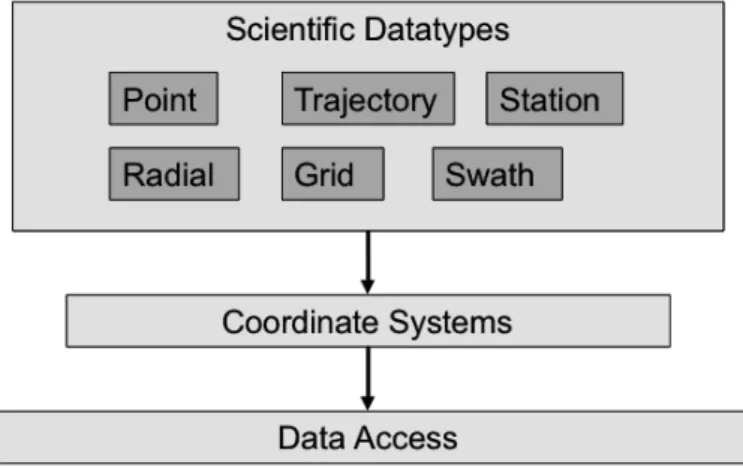
3 Implementation 69 3.1 Scientific data types . . . 69
3.1.1 Gridded data . . . 70
3.1.2 In-situ data . . . 71
3.2 NetCDF for CEOP-AEGIS . . . 71
3.2.1 CF Climate and Forecast Convention . . . 73
3.2.2 Dapper In-situ Convention . . . 80
3.2.3 NetCDF implementation for CEOP-AEGIS . . . 89
3.3 CEOP-AEGIS Data Interface . . . 93
3.3.1 Intermediate data model . . . 95
3.3.2 Data Interface dependencies . . . 98
3.3.3 Data Interface usage . . . 98
3.3.4 Data Interface modules . . . 105
4 Conclusion 111
4.1 Results . . . 111
4.2 Discussion . . . 114
4.3 Outlook . . . 117
A Appendix 119 A.1 CD-ROM of project data . . . 119
A.2 Flood occurrence maps . . . 121
A.2.1 Flood occurrence May . . . 122
A.2.2 Flood occurrence August . . . 123
A.3 CEOP-AEGIS Data Portal . . . 124
A.3.1 Capture image of CEOP-AEGIS Data Portal . . . 125
A.3.2 Dapper configuration file . . . 126
A.3.3 DChart configuration file . . . 127
A.4 NetCDF data models for CEOP-AEGIS . . . 130
A.4.1 Data model for gridded data . . . 131
A.4.2 Data model for in-situ data . . . 132
A.5 Upstream data interface . . . 133
A.5.1 Data Interface data flow . . . 134
A.5.2 Data Interface modules and classes . . . 135
A.5.3 Data Interface NetCDF metadata file for gridded data 136 A.5.4 Data Interface NetCDF metadata file for in-situ data . 137 A.5.5 Data Interface coordinate metadata file for gridded data138 A.5.6 Data Interface coordinate metadata file for in-situ data 138 A.5.7 Data Interface UI main program . . . 139
A.5.8 Data Interface UI GrADS component . . . 140
A.5.9 Data Interface UI GDAL component . . . 141
A.5.10 Data Interface UI CSV component . . . 142
A.5.11 Data Interface settings file for gridded data . . . 143
A.5.12 Data Interface settings file for in-situ data . . . 144
A.5.13 Data Interface batch file for data conversion via GrADS 144 A.5.14 Data Interface batch file for data conversion via GDAL 145 A.5.15 Data Interface batch file for data conversion via CSV . 146 A.6 Pydoc documentation for upstream data interface . . . 147
A.6.1 grads_2Interface.py . . . 148 A.6.2 gdal_2Interface.py . . . 153 A.6.3 csv_2Interface.py . . . 160 A.6.4 interface_Main.py . . . 165 A.6.5 interface_Settings.py . . . 170 A.6.6 interface_Control.py . . . 173 A.6.7 interface_Model.py . . . 177
A.6.8 interface_ModelUtilities.py . . . 183 A.6.9 interface_Data.py . . . 187 A.6.10 interface_ProcessingTools.py . . . 189
Bibliography 195
List of Figures
1.1 Area of interest of the Qinghai-Tibet Plateau and basins of
rivers that originate from this plateau . . . 2
1.2 Illustration of the CEOP-AEGIS project elements . . . 4
1.3 CEOP-AEGIS contributions to GEOSS . . . 5
1.4 CEOP-AEGIS data service chain . . . 7
2.1 Data management of array-oriented scientific data in NetCDF 15 2.2 UML diagram of the NetCDF 3 data model . . . 23
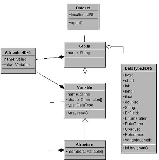
2.3 UML diagram of the NetCDF 4 data model . . . 30
2.4 UML diagram of the HDF 5 data model . . . 32
2.5 Three layer model of the Common Data Model . . . 33
2.6 UML diagram of the NCML Metadata Object Model . . . 37
2.7 OPeNDAP system architecture and data flow . . . 43
2.8 UML diagram of the OPeNDAP data model . . . 50
2.9 Dapper system architecture . . . 61
2.10 Capture image of the DChart user interface . . . 65
2.11 DChart system architecture . . . 66
3.1 Gridded data example . . . 70
3.2 Map of flood occurrence . . . 109
List of Tables
1.1 CEOP-AEGIS project dataset deliverables . . . 11 2.1 Registered NetCDF 3 conventions . . . 40 2.2 OPeNDAP URL suffixes defining the OPeNDAP services . . . 46 2.3 OPeNDAP to CDM transformation rules . . . 56 2.4 Dapper supported in-situ conventions . . . 62 3.1 CF convention data provenance attributes . . . 75 3.2 Components of intermediate data model . . . 95 3.3 Internal Python 2.6 library dependencies of the Data Interface 99 3.4 External library dependencies of the Data Interface . . . 99
List of Listings
2.1 OPeNDAP DDS for a gridded dataset . . . 52 2.2 OPeNDAP DAS for a gridded dataset . . . 52 3.1 NetCDF CDL representation for a gridded dataset . . . 79 3.2 OPeNDAP DDS for Dapper in-situ time-series collection . . . 83 3.3 OPeNDAP DAS for Dapper in-situ time-series collection . . . 84 3.4 NetCDF CDL representation for a Dapper in-situ time-series
collection . . . 87 A.1 Dapper configuration file . . . 126 A.2 DChart configuration file . . . 127 A.3 Data Interface NetCDF metadata file for gridded data . . . . 136 A.4 Data Interface NetCDF metadata file for in-situ data . . . 137 A.5 Data Interface coordinate metadata file for gridded data . . . 138 A.6 Data Interface coordinate metadata file for in-situ data . . . . 138 A.7 Data Interface UI main program . . . 139 A.8 Data Interface UI GrADS component . . . 140 A.9 Data Interface UI GDAL component . . . 141 A.10 Data Interface UI CSV component . . . 142 A.11 Data Interface settings file for gridded data . . . 143 A.12 Data Interface settings file for in-situ data . . . 144 A.13 Data Interface batch file for data conversion via GrADS . . . . 144 A.14 Data Interface batch file for data conversion via GDAL . . . . 145 A.15 Data Interface batch file for data conversion via CSV . . . 146
Nomenclature
AJAX Asynchronous Java and XML
API Application ProgrammingInterface
ASCII American Standard Code for Information Interchange
ASIS Atmospheric Science Information Systems
ASTER Advanced Spaceborne Thermal Emission and Reflection
Radiometer
CDL Network CommonData form Language (here of NetCDF)
CDM Common Data Model (of Unidata)
CDP Climate Data Portal (of EPIC)
CEOP-AEGIS Coordinated Asia-European long-term Observing system of Qinghai–Tibet Plateau hydro-meteorological processes and theAsian monsoon systEm withGround satelliteImage data and numerical Simulations
CF Climate andForecast (Metadata Convention for NetCDF)
CGI Common Gateway Interface
COARDS Cooperative Ocean/Atmosphere Research Data Service
CORBA Common Object Request BrokerArchitecture
CSV Comma Separated Value(s)
DAP Data Access Protocoll (here of OPeNDAP)
DAS Data AttributeStructure (here of OPeNDAP)
DDS Dataset Descriptor Structure (here of OPeNDAP)
DODS Distributed OceanographicData System
DOM Document Object Model
EB ExaByte (260Byte)
EPIC EastPacificInvestigation ofClimat Processes in the Cou-pled Ocean-Atmosphere System (of PMEL)
FTP File Transfer Protocol
GB GigaByte (230Byte)
GCS Geographic CoordinateSystem
GDAL Geospatial Data Abstraction Library
GDS GrADS Data Server
GEOSS Global Earth ObservationSystem of Systems
GEO Group onEarth Observations
GIS Geographic Information System
GML Geography Markup Language
GrADS GridAnalysis and Display System
GRAPES Global/RegionalAssimilation and Prediction System
GRIB Gridded Binary
HDF Hierarchical Data Format
HPCC High Performance andComputing (here of NOAA)
HTML HypertextMarkup Language
HTTPD HypertextTransfer Protocol Daemon
ID Identification Number
IEEE Institute of Electrical and Electronics Engineers
IIOP Internet Inter–ORB Protocol (here of CORBA)
ISO International Standard Organization
JAR Java Archive
JGOFS JointGlobar Ocean FluxStudy project
JPEG JointPhotographicExperts Group
LFS Large File Support
LIDAR Light Detection andRanging
MIME Multipurpose Internet MailExtension
NaN Nota Number (IEEE conform)
NASA NationalAeronautics and Space Administration
NcML NetCDF Markup Language
NetCDF Network Common Data Form
NOAA NationalOceanic andAtmospheric Administration
NOVDS NationalVirtual Ocean Data System
OPeNDAP Open-sourceProject for aNetwork Data Access Protocol
ORB Object Request Browser (here of CORBA)
OSI OpenSystem Interconnection
PCS Projected CoordinateSystem
PMEL Pacific MarineEnvironmental Laboraty
RADAR Radio Detection and Ranging
RDBMS Relational DatabaseManagement System
SQL Structured Query Language
TCP Transmission Control Protocol
TDS THREDDSData Server
THREDDS ThematicRealtimeEnvironmentalDistributedDataServices
TSV TabSeparated Value(s)
UCAR University Corporation for Atmospheric Research
UI User Interface
UML Unified Modeling Language
URL Uniform ResourceLocator
WGS84 World Geodetic System 1984
WMO World Meteorological Organization
XDR ExternalData Representation (here of NetCDF)
XML ExtensibleMarkup Language
Chapter 1
Introduction
Over 1.4 billion people, the agriculture, the economics, and the entire ecosys-tem of south-east Asia strongly depend upon the monsoon climate and the water supply of the rivers Indus, Ganges, Brahmaputra, Yangtze and Yellow River – this is over 20 % of the global population (CEOP-AEGIS Inc. 2009; European Comission, 2010; Immerzeel, van Beek, & Bierkens, 2010). The headwater of these rivers is influenced by the monsoon system and mostly fed from the upstream snow and ice reserves of the Tibetan Plateau as well as from surrounding high mountain ranges (Immerzeel et al., 2010). These seasonal water reserves however are likely to be influenced by climate change, since the number of floods and droughts does increase – with the result that the downstream water supply and subsequently the food security for people living in the basins of these five major rivers of south-east Asia is negatively affected (CEOP-AEGIS Inc. 2009; Immerzeel et al., 2010).
Immerzeel et al. (2010) could prove in their investigation that the ef-fects of climate change on the water availability and subsequently on the food security can not be generalized among the five major Himalayan river basins Indus, Ganges, Brahmaputra, Yangtze and Yellow River, and that it differs substantially. In this regard, glaciers that feed the Himalayan rivers with melt water can be regarded as key indicators for climate change (Bolch, Buchroithner, Pieczonka, & Kunert, 2008). Bolch et al. (2008) investigated glacier changes in the Khumbu Himal in Nepal by the use of Corona, Land-sat TM and ASTER Land-satellite data from 1962 to 2005. The authors could determined an average glacier area loss in the Khumbu Himal of about 5 % between 1962 and 2008, with the highest decreasing rates measured for the time period between 1992 and 2001 (Bolch et al., 2008).
Concluding from these and other related investigations, the Tibetan Plateau covering an extent of about 2.5 million square kilometers at an average alti-tude higher than 4,700 m can be considered as an important factor regarding
the climate and hydrology of south-east Asia, since it significantly influences the downstream river flows (CEOP-AEGIS Inc. 2010; Immerzeel et al., 2010; Menenti, Jia, & Colin, 2010; Xu & Zhang, 2008). The Tibetan Plateau not only regulates the water resources for all south east Asian rivers, but also plays a significant impact on the Asia monsoon and the atmospheric circula-tion (Xu & Zhang, 2008). A major interest in terms of flood and drought and consequentially of food security and changing environment is subsequently the correct understanding of the linkage of land processes and of the Asian Monsoon System on the Tibetan Plateau (CEOP-AEGIS Inc. 2010; Menenti et al., 2010).
Figure 1.1 on page 2 defines the area of interest on the Qinghai-Tibet Plateau, as well as the basins of the rivers Indus, Ganges, Brahmaputra, Irrawaddy, Salween, Mekong, Yangtze and Yellow River that originate from this plateau and are regulated by its water resources (CEOP-AEGIS Inc. 2010). The range of the area of interest in its longitude is about in between 70.0◦E and 110.0◦E and in its latitude about in between 25.0◦N and 43.0◦N.
Figure 1.1: Area of interest of the Qinghai-Tibet Plateau and the basins of the rivers Indus, Ganges, Brahmaputra, Irrawaddy, Salween, Mekong, Yangtze and Yellow River that originate from this plateau and that are regulated by the Plateau water resources (CEOP-AEGIS Inc. 2010)
1.1
CEOP-AEGIS project
CEOP-AEGIS stands for “Coordinated Asia-European long-term Observing system of Qinghai-TibetPlateau hydro-meteorological processes and the Asian monsoon systEm withGround satelliteImage data and numericalSimulations”. This collaborative small-scaled research project is funded by the European Commission under the Seventh Framework Program “Improving observing systems for water resource management” (grant agreement number 212921) and is coordinated by the Image Sciences, Computer Sciences and Remote Sensing Laboratory (LSIIT) of the University of Strasbourg in France (CEOP-AEGIS Inc. 2011; Menenti et al., 2010). The project web page can be accessed under the URL http://www.ceop-aegis.org/.
The CEOP-AEGIS project was born in May 2008 out of the needs to improve the knowledge of the hydrology and meteorology of the Qinghai-Tibetan Plateau with its primary goals to demonstrate the benefits of earth observations to better monitor and model key hydro-climatological variables. Its duration is scheduled until May 2012 (CEOP-AEGIS Inc. 2010; Menenti et al., 2010; Menenti & Colin, 2011). The scope of this project is focused on prototyping innovative algorithms based on gathered observations from an existing ground measurement network as well as out of reliable long-term space-borne observation systems with instruments on board of current and future satellites. Data continuity for these systems will be guaranteed (CEOP-AEGIS Inc. 2010; Menenti et al., 2010).
The purpose of this observing system is the monitoring and determina-tion of the water yields at the Qinghai-Tibetan Plateau. Another purpose is to observe the snow evolution, vegetation cover, surface wetness and surface flux to analyze the complex linkage with connective activity, extreme pre-cipitation events and the Asian Monsoon. The observations collected within this project will help to clarify the role of the hydrology of the Qinghai-Tibet within the Asian Monsoon system and determine the amount of headwater that is going into the seven major rivers of south-east Asia. The challenge of this project consists in this aspect in an efficient fusion of the available data rather as in the focus on separate observations (CEOP-AEGIS Inc. 2009, 2010; European Comission, 2010; Menenti et al., 2010; Menenti et al., 2010) One of the three elements foreseen within this project concerns the obser-vations in the terms of the water balance of the plateau, such as precipitation, soil water, melt water from snow and glaciers, vegetation cover, or evapo-ration. The second project element forms a distributed hydrological model that will serve for the calculation of the water balance, and of a meso-scale atmospheric model that will serve for investigations about the Asian Mon-soon. A data acquisition and processing system will be developed within the
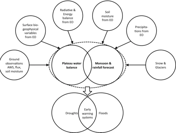
CEOP-AEGIS project to merge the observation sources into a single Earth Observation System. The data of this system will then serve as forcing or validation parameters for a GIS-based hydrological model. This hydrologi-cal model will lead to a prototype of a water balance monitoring system of the complete Qinghai-Tibet Plateau, and also produce three-year datasets on weekly and monthly basis of the water balance terms. A drought and flood early warning system will be demonstrated by the use of the resulting time series of observations and model outputs as the third element of this project(CEOP-AEGIS Inc. 2010; Menenti et al., 2010). Figure 1.2 on page 4 illustrates the CEOP-AEGIS concept that is consisting of the following three elements: observations, models, and early warning systems (CEOP-AEGIS Inc. 2010).
Figure 1.2: Illustration of the three CEOP-AEGIS project elements, con-sisting of heterogeneous observations, models, and early warning systems (CEOP-AEGIS Inc. 2010)
Eighteen participating organizations from China, France, Germany, India, Italy, Japan, the Netherlands and Spain, and about a hundred participat-ing scientist are involved in the scientific tasks that are split in eleven work
packages plus one work package for management tasks (CEOP-AEGIS Inc. 2011). The resulting highly innovative project datasets of the hydrology and climatology of the Tibetan Plateau will be made available to the scientific community as contribution to the Global Earth Observation System of Sys-tems (GEOSS) initiative. This contribution is part of the Water and Ecosys-tems GEO societal benefit areas of GEOSS with Massimo Menenti as its co-leader. The CEOP-AEGIS coordination team is also involved in the Sci-ence and Technology Committee of the Group on Earth Observation (GEO) (CEOP-AEGIS Inc. 2010; European Comission, 2010; Menenti, Colin, & Jia, 2011). More than 130 governments and international organizations partic-ipate voluntary in GEO to coordinating with its secretariat hosted by the WMO in Geneva the efforts to construct a Global Earth Observation Sys-tem of SysSys-tems (GEOSS) by the year 2015 (European Comission, 2010). The open access of the CEOP-AEGIS project data within GEOSS is of primary interest not only for the related scientific community, but also for human societies and water resource management institutions (Menenti et al., 2011). Figure 1.3 on page 5 gives an overview of the contributions of CEOP-AEGIS to GEO and GEOSS (Menenti et al., 2011).
Figure 1.3: Overview of the contributions of CEOP-AEGIS to GEO and the GEOSS Social Benefit Areas (Menenti et al., 2011)
1.2
Problem statement
A large amount and variety of multidimensional earth observation datasets will be collected and evaluated during this project and must be made available to the scientific community in a standardized form. This large panel of
datasets deliverables consists of array orientated gridded data from remote sensing products and model outputs as well as of in-situ measurements from ground stations (Menenti et al., 2011).
Regular and global coverage data of atmospheric and surface properties will be provided by observing systems on board of current and future satel-lites. These observing systems consist of multi-spectral imaging radiometers, microwave radiometers, RADAR and backscatter LIDAR, and will guarantee the required spectral, temporal and spatial coverage. Satellite observations consist of measurements of snow and vegetation cover, temperature and sur-face albedo. Furthermore they consist of satellite based estimates of energy and water fluxes as well as of top soil moisture over the plateau. Ground observation stations at limited but representative sites do cover almost ev-ery type of land surfaces of the Tibetan Plateau and will provide reference datasets of weather measurement parameters as well as of radiative and en-ergy balance measurement parameters. This includes measurements of radia-tive and turbulent fluxes as well as of soil moisture. Integrated ground and satellite observations will serve for the measurement of precipitation and for the estimation of melt water from glacier and snow (CEOP-AEGIS Inc. 2009, 2010; Menenti et al., 2010). Table 1.1 on page 11 lists all of these dataset de-liverables within the CEOP-AEGIS project (Menenti & Colin, 2011; Menenti et al., 2011).
All of the resulting highly innovative project data must be made available to the scientific community via an online data repository. This should be a user-friendly and efficient web based data sharing platform that allows the exchange of project related satellite, model and ground based data and metadata information. The new CEOP-AEGIS Data Portal should serve as information system of hydro-meteorological data of the Tibetan Plateau for the scientific community and follow the GEO Data Sharing Principles. The hardware infrastructure will be hosted in Beijing by the Institute for Tibetan Plateau Research (ITP) at the Chinese Academy of Science (CEOP-AEGIS Inc. 2010; Menenti et al., 2011). It is scheduled that the CEOP-AEGIS Data Portal will be registered by May 2012 as GEOSS component to make all foreground data of the project freely available for the community (Menenti & Colin, 2011; Menenti et al., 2011).
The amount of data produced within this project comes from various project partners and is extensive. Moreover, it is heterogeneous in its con-tent, and also in its type of storage and its metadata description. This heterogeneity becomes also obvious regarding the dataset deliverables within the CEOP-AEGIS project (see table 1.1 on page 11) that consist of gridded and in-situ data, coming from ground observation measurements, satellite imagery and model output. The project partners that provide this data are
heterogeneous as well, since they are working in different scientific fields with their specific scientific related background and idea in what form to store and provide data.
However, any foreground CEOP-AEGIS project data needs to be made available in a standardized form, so that it can be published within a data repository where users can browse and access data. The data consumers in their entirety that take advantage of this data repository are heterogeneous as well, and are also coming from various scientific disciplines. The users of the CEOP-AEGIS Data Portal though may expect that the data and metadata provided by this interface is accessible in a common and standardized form that does follow international standards and conventions to achieve a high level of interoperability by allowing a maximum of compatibility and func-tionality with the users applications. They may also expect a well-founded metadata description model that is provided with the data, so that they can correctly understand the content of the data and work with it. Figure 1.4 on page 7 illustrates this design principle of the CEOP-AEGIS data services chain from data producers to end users (Menenti & Colin, 2011).
Figure 1.4: CEOP-AEGIS design principle of a data service chain from data producers to end users (Menenti & Colin, 2011)
Hence advanced data models for data storage and data exchange are needed to provide standardized project output via the new CEOP-AEGIS Data Portal.
1.3
Objective of this thesis
The data portal and the data and metadata modeling and storage as well should all follow international standards and rely on open-source solutions. The format chosen for the storage of CEOP-AEGIS output data is NetCDF, developed by Unidata. This data format is flexible, self-describing, and ca-pable to store large sets of array-oriented multidimensional data in a single file. It is an open-source solution that can be used in combination with the OPeNDAP technology to access NetCDF datasets remotely over the internet by the use of an OPeNDAP server and an OPeNDAP enabled client.
The data portal should consist of a back-end data server for data stor-age and of a front-end user interface for data access. This web based user interface will represent the CEOP-AEGIS Data Portal and will be part of a contribution to the Global Earth Observation System of Systems (GEOSS). The back-end data server should be based on the OPeNDAP technology, so that it can be used in combination with the NetCDF data format. The front-end must be a web based user interface that should be accessible with any internet browser by taking advantage of the the OPeNDAP technology. This can be achieved by the use of the Dapper / DChart open-source technology, developed by Joe Sirott at NOAA/PMEL.
The objective of this thesis is two-fold with one final additional element: • On the one hand, the technical capabilities of the NetCDF data format as well as its data modeling and metadata modeling standards need to be profoundly evaluated in order to take correct decisions on how to produce suitable NetCDF datasets. Moreover, the OPeNDAP data for-mat and protocol as well as the Dapper / DChart technology on which relies the data repository and user interface must be evaluated with the same elaborateness. This is important for the decision making process of NetCDF modeling so that interoperable datasets with a maximum compatibility and functionality to OPeNDAP and Dapper / DChart as well can be created. Out of these evaluations, decisions must be taken about what NetCDF data format, data model and metadata conven-tion should be employed within CEOP-AEGIS for the project output data. Following from this, the resulting NetCDF implementation for the output data must be adapted to the needs of the CEOP-AEGIS project, as well as to the technical requirements of Dapper / DChart.
• On the other hand, any data provided from CEOP-AEGIS project part-ners need to be post-processed and merged together in space and time to obtain aggregated and standardized high valuable datasets that can be feed to the CEOP-AEGIS Data Portal. For doing so, an upstream data interface that is intended to convert data from project partners to OPeNDAP compliant NetCDF datasets must be designed and im-plemented within this thesis. This data interface must produce stan-dardized NetCDF output data that is respecting the decision about NetCDF data and metadata modeling, as they were taken in the pre-vious detailed evaluation steps of NetCDF, OPeNDAP and Dapper / DChart. The data interface should easily allow to add and modify metadata. Some functions that check if the defined NetCDF model is obeyed would be useful. It should also be possible to modify this interface without much work so that also unexpected data formats can be read and standardized NetCDF output data be produced out of it.
• Finally, some already available project datasets should be post-processed through the developed data interface and converted into the designated form of NetCDF. This data should subsequently be published in the CEOP-AEGIS Data Portal. Dapper and DChart need to be configured for this purpose. For some case studies, a few additional cartographic products in form of animations may be produced out of the standard-ized data.
In summary, it is essential to properly design a data interface that con-verts heterogeneous input data of project partners in standardized and ag-gregated output data files. These files must be based on a standardized, consistent and adequate data and metadata model to ensure maximum com-patibility and functionality within the CEOP-AEGIS Data Portal and subse-quently interoperability within the use by the related scientific communities. The results of this thesis will be a contribution to the CEOP-AEGIS work package number eight (WP 8): Monitoring the water balance and water yield of the Plateau. This work package defines intentions in regard of an inte-grated analysis of ground and satellite observations in order to estimate the water balance of the Tibetan Plateau, as well as in matters of the develop-ment and demonstration of a prototype observation system to monitor the water yield of this area. This includes the establishment of a pilot database management system that supports the hydrological monitoring of the Plateau (CEOP-AEGIS Inc. 2009).
1.4
Structure of this work
To achieve these objectives, the following structure was chosen in this docu-ment:
Chapter 2 provides the technical foundations of NetCDF, OPeNDAP and Dapper / DChart, so that a suitable NetCDF implementation for the output data of the CEOP-AEGIS project can be derived. This chapter does not only provide the important theoretical backgrounds about the technologies that are used within this thesis, but does also serve as useful documentation. This concerns in particular the section about Dapper and DChart, since these technologies are employed as part of the CEOP-AEGIS Data Portal and need to be configured and modified for each new dataset that is loaded to the portal.
The second important element of this thesis is related to the methodology part on the basis of the discussed theoretical backgrounds and is documented in the implementation chapter 3. It concerns in particular the design and implementation of the upstream data interface program to convert heteroge-neous input data of project partners to standardized NetCDF output files. The implemented NetCDF data model for the output data is based on the knowledge gained in the previous chapter. Furthermore, this chapter con-tains a short section about the creation of a few cartographic products that could be finally generated on the basis of standardized project data.
To conclude, the last chapter 4 discusses the results of this work and provides an outlook for possible future developments out of the realized work. The appendix A contains a large amount of documentation regarding the implemented data interface for data conversion to standardized NetCDF output files constrained in the determined data model.
Deliverables CEOP-AEGIS datasets
D 1.4 Final 3 years dataset on aerodynamic and thermodynamic
vari-ables over the different land surfaces of the Tibetan Plateau
D 1.5 Area-integrated surface fluxes from ground measurements
D 2.5 Dataset including vegetation cover, surface albedo, LAI (Leaf
AreaIndex), aerosol optical depth, precipitable water vapor,
soil/-foliage component and land surface emissivity/temperatures for a 3 years period and over the entire plateau
D 3.4 Validated complete time-series maps of fluxes over 3 years, with a
target frequency of one week
D 4.1 Collection of consistent continuous in-situ soil moisture
measure-ments at regional scale
D 4.3 Estimation of soil moisture from Geostationary Satellite (GS) data
D 4.4 A data product of the plateau using different sensors
simultane-ously
D 4.5 Validation results and documentation of uncertainties of
estima-tions of soil moisture from Geostationary Satellite (GS) data (op-tical remotely sensed data)
D 5.3 Provide 3-years 3-D gridded radar data for case studies
D 5.4 Provide high space and temporal resolution precipitation data
re-trieved from radar, satellite (both VIS-IR and MW) and ground rain gauge data for case studies
D 6.4 Validated dataset (include snow cover area, SWE, glacier area and
storage from satellite data, and assimilation datasets) from 2008 to 2010
D 8.2 Time series analysis of water balance data
D 8.3 Prototype of data collection, integration and processing system to
monitor the plateau water balance
D 9.1 Vegetation dynamic maps over a long-term period
D 9.2 Maps of drought vulnerability zones in the study area
D 9.5 Anomalies maps of rainfall, vegetation response
D 10.3 Flood inundation, flood hazard and flood risk zone maps based on
the hydraulic modeling and analysis of satellite data
D 10.4 Real time forecasting of flood inundation, depth, areal extent and
return period of flooding
D 10.5 Case studies on flood events in the period 1999–2010
Table 1.1: CEOP-AEGIS project dataset deliverables (Menenti & Colin, 2011; Menenti et al., 2011)
Chapter 2
Theoretical foundations
Caron (2011) states that “[. . . ] HDF, NetCDF and OPeNDAP are [arguably] the best/widely used general purpose scientific data format/access protocols”. NetCDF became a de facto standard in the atmospheric, climatological and oceanographic sciences for storing model outputs and climatological prod-ucts in the atmosphere, as mentioned by Hankin et al. (2009). It can serve as linkage between data consumers and data providers for the accessing, creat-ing and sharcreat-ing of array-oriented multidimensional scientific data. The data model of NetCDF is simple, flexible, self-describing and discipline-neutral in a sense that it is general enough for the use within many different scientific communities (Hankin et al., 2009). It insulates applications from the details of a data format and allows, as Brown, Folk, Goucher, and Rew (1993) ex-plain, to share data among different architectures by providing flexible data access. The community that takes advantage of NetCDF is multi-disciplinary and finds followers especially in the geosciences climatology, hydrology, me-teorology and oceanography (Hankin et al., 2009; Nativi et al., 2004; Nativi, Caron, Domenico, & Bigagli, 2008; Rew, 2004).
NetCDF that can be assigned to the ASIS (Atmospheric Science Infor-mation Systems) community is different from the more complicated rela-tional data models of Geographic Information Systems (GIS), as Nativi et al. (2004), Nativi et al. (2008) and Rew (2004) remark. A NetCDF file con-tains in general multi-dimensional datasets that do not necessarily need to be spatially related and that can become very large in their size. NetCDF data is usually defined by three spatial and one temporal coordinate axes, while GIS data focuses generally only on two. Georeferencing depends upon conventions and is not part of a data file. Another difference is the root concept, that focuses in GIS data models on feature oriented vector objects residing on the earth surface, but on large gridded multidimensional data ob-jects in NetCDF. In this regard, data is seen in NetCDF as discrete points in
a continuous function space of the three spatial and one temporal dimension (Nativi et al., 2004; Nativi et al., 2008; Rew, 2004).
OPeNDAP is a standard data format and protocol that is often used in combination with NetCDF to access remote distributed scientific data over the internet (Nativi et al., 2008). Dapper is an OPeNDAP enabled web server that can be employed to serve NetCDF datasets to a front-end DChart user interface. This web based user interface will be implemented as the CEOP-AEGIS Data Portal. Employing the combination of NetCDF, OPeNDAP and Dapper / DChart – that are all based on open-source solutions – allows to achieve the objectives of this thesis as they are defined in section 1.3.
This chapter is a literature survey to obtain the technical foundations of NetCDF, OPeNDAP and Dapper / DChart. Out of the knowledge ob-tained in this chapter, an upstream data interface designed to convert data of project partners in standardized OPeNDAP and Dapper / DChart compliant NetCDF files will be developed. This is documented in chapter 3. The anal-ysis done in this chapter does not only provide background knowledge, but may also serve as documentation, in particular regarding the CEOP-AEGIS Data Portal that is based on Dapper / DChart.
The literature survey of this chapter is mostly based on publications of authors that developed these technologies. For NetCDF, these are – apart from many other NetCDF users that also contributed to the development – John Caron, Glenn Davis, Harvey Davies, Steve Emmerson, Ed Hartnett and Russ Rew of the Unidata Program Center. Within OPeNDAP are involved – among others – Peter Cornillon, Glenn Flierl, James Gallagher, Steve Hankin, James Potter and Tom Sgouros. Dapper and DChart were developed by Joe Sirott at PMEL/NOAA.
2.1
NetCDF
Unidata Inc. (2011) defines the Network Common Data Form (NetCDF) as “[. . . ] a set of software libraries and machine-independent data formats that support the creation, access, and sharing of array-oriented scientific data.” NetCDF consists – as Caron (2009), Hartnett (2009) and Rew (2004) docu-ment – of file formats, data models and software libraries with associated pro-gramming interfaces (API). The file name extension is.nc. NetCDF was de-veloped by the Unidata atmospheric science community in Boulder, Colorado (USA). This institution maintains and supports NetCDF software, standards, updates and documentation. Unidata is primarily funded by the US National Science Foundation (NSF) and part of the University Corporation for Atmo-spheric Research (UCAR) (Hartnett, 2009; Rew, 2004). NetCDF is under an
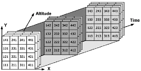
open source license and was officially endorsed as a common encoding stan-dard by the Steering Committee of the United States Federal Geographic Data Committee (FGDC) in 2010 (Rew, 2004; Rew, Caron, Hartnett, & He-imbigner, 2010). The NetCDF package was designed for the earth scientist community to store different kinds of scientific multidimensional data, such as array-oriented regular-spaced grids, satellite, or radar images, but in some respects also point observations and time series data (Hartnett, 2009; Nativi, Caron, Davis, & Domenico, 2005; Rew et al., 2010). The data management of array-oriented scientific data in NetCDF is illustrated in figure 3.1 on page 70 (University of Texas at Austin, 2007).
Figure 2.1: Illustration of the data management in array-oriented scientific data in NetCDF 3 (University of Texas at Austin, 2007)
Brown et al. (1993) and Rew et al. (2010) document that the NetCDF package was initially created as interface to access real-time meteorological data with Unidata’s software applications that were running on different computing platforms. The actual NetCDF format evolved out of NASA’s Common Data Format (CDF) in 1989, when an XDR-based (ExternalData Representation) prototype implementation of the NetCDF interface in the language C was first developed by Unidata (Rew et al., 2010). The name NetCDF is to emphasize the network transparency by employing XDR in homage to the original CDF format of NASA (Rew & Davis, 1990). Beside the contribution of numerous NetCDF users, the software was mainly developed by John Caron, Glenn Davis, Harvey Davies, Steve Emmerson, Ed Hartnett
and Russ Rew of the Unidata Program Center (Rew, n.d.).
Rew (2004) explains that the purpose of NetCDF is to separate users, data and applications from machine architectures and format details. NetCDF is a scalable file format that allows the efficient and direct access to small subsets of data elements which can be part of large multidimensional datasets – with-out the need to first access the complete dataset. Ancillary metadata that is providing additional information about the containing data can be attached to a NetCDF file, making it a self-describing data format (Brown et al., 1993; Rew, 2004, n.d. Rew et al., 2010). Applications can not only extract data val-ues, but also information about data values as well as relationships among data components in case that data is self-describing (Brown et al., 1993). NetCDF files can be accessed directly without intermediate translation by any developed NetCDF API installed on any supported common computing platform. This makes NetCDF a portable and machine independent data format. Without redefining the structure or copying the dataset, it is also possible to append data properly to a well structured NetCDF file (Brown et al., 1993; Rew, n.d. Rew et al., 2010).
On important scope of NetCDF is to support the access to small subsets of large datasets in an efficient way. Regarding this scope, the main problem however of relational database management systems is – according to Brown et al. (1993) and Rew et al. (2010) – the lack of efficient support for large mul-tidimensional data arrays with their hierarchical structures. Furthermore, an adequate performance regarding the size and complexity of many scientific datasets as well as the type of access is in general not provided by relational database systems (Brown et al., 1993). As a result does NetCDF not provide the functionalities of a relational database management systems, since, as Rew et al. (2010) argue, the software for such systems is not suitable for the kind of data for that NetCDF was designed. Keyed access to data and multiple concurrent writing is subsequently not possible with NetCDF (Rew, 2004).
2.1.1
Data models
Nativi et al. (2008) calls a data model in a philosophical sense as “[. . . ] a way of thinking about scientific data by applying a data model theory”. A data model is an abstraction about how scientific data is stored, organized and accessed. The objects of a data model are stored and persisted in a file format. The details and constrains of a persistent file format and of a particular API are removed in an abstract data model (Caron, 2006, 2008, 2009; Caron & Domenico, 2006; Nativi et al., 2008).
li-braries with associated APIs that provide machine-independent formats of NetCDF (Rew & Davis, 1990). Rew et al. (2010) mention that there are currently two data models existing in NetCDF: The classic NetCDF 3 model and the enhanced NetCDF 4 model. The NetCDF classic model consists of the NetCDF 3 classic format, the NetCDF 3 64-bit offset format and the NetCDF 4 classic format. The NetCDF enhanced model consists of the NetCDF 4 format .
Hartnett (2009) affirms that Unidata guarantees backward compatibility to older NetCDF datasets of any format and model, so that data stored in older versions of NetCDF will always remain accessible, no matter what model or format of NetCDF was used. The structure of a NetCDF file is immutable after its definition and after data values were subsequently written to NetCDF variables, as Caron (2004) states. In case that the file structure needs to be changed after its definition, the entire dataset needs in general to be copied to a newly structured NetCDF dataset (Nativi et al., 2005). Objects such as dimensions and variables are created subsequently in a NetCDF file, and the API of NetCDF does keep track of the creation order of these objects (Rew et al., 2010).
2.1.2
Datasets
Any form of data that can be accessed through the NetCDF API can be considered as dataset, according to Caron (2011). A NetCDF 3 dataset forms a collection of the three elements Dimension, Attribute and Variable, that are all identified by an ID and by a name. Only the primitive data types
char, byte, short, int, float and double are supported by NetCDF 3. The NetCDF 4 data model expands this data model with the Group and Structure elements, as well as some more primitive and user defined data types (Caron & Domenico, 2006; Rew, 2004; Rew et al., 2010). A dataset as a generalization of a NetCDF file has always a root group (Caron, 2004).
2.1.3
Dimensions
Dimensions define the coordinate axes of a variable within a NetCDF dataset by specifying its shape (Caron, 2004, 2011; Rew et al., 2010). The shape of a variable is the length of all of its dimensions (Caron, 2004). Dimensions have an index length and establish the index space for variables so that the data within the variables can be located. Associated coordinate variables hold the coordinates of the dimensions that they name (Caron, 2004; Rew et al., 2010). A dimension that forms the shape of a variable must already exist before the variable can be created (Rew et al., 2010).
Rew et al. (2010) states that dimensions can represent real physical di-mensions, such as the longitude or the latitude, but also other quantities, as for example station numbers. Geophysical data is usually represented by the three spatial axes longitude, latitude, height (respective depth) and by the time axis. One or more of these four axes can be collapsed to a single point, as it may be the case for in-situ data (PMEL/EPIC Inc. n.d.).
Dimensions within NetCDF have a name and a length, as documented by Hartnett (2009) and Rew et al. (2010). The length of a dimension can be set to be limited or to be unlimited. If a dimension is limited, its length is determined by an arbitrary positive integer value. The dimensions for the vertical axes, the latitude and the longitude do usually have a limited length. In this case the dimension length must be an arbitrary positive integer value (Rew et al., 2010).
Shared Dimensions
Dimensions may be shared among other variables or not, as remarked by Caron (2010). Shared dimensions have an unique name within aGroup and allow the association of variables with each other. Private dimensions are not shared among other variables and do not have a name. They reside local to one single variable and are therefore anonymous for other variables (Caron, 2004, 2011). Shared dimensions in accordance with NetCDF conventions are used to define coordinate axes of data variables, as explained by Caron (2009, 2010).
Unlimited Dimensions
A dimension can be defined as having an unlimited length to arbitrarily extend a file with additional data. This can be achieved by adding data along this unlimited dimension that will increase in its length (Hartnett, 2009). Otherwise the length of a dimension remains immutable in case that it is not defined as unlimited (Caron, 2004). The length of an unlimited dimension is the number of its actual records (Rew et al., 2010). Unlimited dimensions are also called record dimensions since they are generally used for recording new data along the time axis. NetCDF 3 only allows the optional use of one single unlimited dimension, and this dimension must be the dimensions of the highest order that is used. The dimension with the highest order in an multidimensional array is the slowest changing dimension, whereas the dimensions with the lowest order varies fastest (Rew et al., 2010).
2.1.4
Variables
Information is generally not provided per file, but per variable, that is the basic unit to store a large amount of data with indexed values in NetCDF. Variables are one or multidimensional rectangular objects in the form of arrays that serve as container for indexed data values of the same type and optionally of a set of attached attributes (Caron, 2004, 2011; Hartnett, 2009; Rew et al., 2010). A variable has a name, a data type, a shape and optionally associated attributes. Its shape is defined by the length of an associated set of already existing dimensions. Local attributes can be attached to a variable to provide metadata information about the data. Depending on the purpose of these attributes, its values must have the same unit as the variable data (Caron, 2004, 2011; Rew et al., 2010). A variable with an unlimited dimension has no fix length and can grow to an arbitrary size along this unlimited dimension. Such a variable is called a record variable, as Rew et al. (2010) remarks.
All data in an array has to be of the same data type, that is limited within the NetCDF classic model to the six primitive data typeschar,byte,
short, int, float and double. Additional data types are provided by the enhanced data model of NetCDF 4 (Caron, 2010; Rew et al., 2010). The number of dimensions of a variable forms the rank. NetCDF variables are implemented in arrays that can have an arbitrary rank (Caron, 2004). A dimensionless variable is a scalar that consists only of one single value. A variable with one single dimension is a vector, and a variable with a rank of two is a matrix (Rew et al., 2010).
The elements specifying a variable can not be modified after its definition since they are determined at the creation date of the variable and before data values were assigned. This includes the data type, the rank and the shape of an array that is defining a variable. Data values however are mutable. From this it follows that empty variables with no values may exist (Caron, 2004; Rew et al., 2010). The efficient data access of NetCDF by specifying variables instead of positions in a file permits independent access from other data which may have been stored in other variables. This data accessing strategy helps to maximize compatibility due to the immunity of data format changes (Rew et al., 2010). Depending on the purpose of a variable, it is necessary to differentiate between coordinate variables as independent variables and data variables as variables dependent to coordinate variables.
Coordinate Variables
Caron (2004) defines coordinate axes as generalization of coordinate vari-ables. A coordinate system is defined by a set of coordinate axes that are implemented by coordinate variables to locate data in physical space and time (Caron, 2004).
A variable that has the same name as its associated dimension is called a coordinate variable. A coordinate variable is an one-dimensional vector in the form of an array. It distinguishes the data elements along an axis of a data array by defining coordinates that correspond to the index of the associated dimension within this data variable. All dimensions have in general one-dimensional coordinate variables (Caron, 2004, 2010; Rew et al., 2010).
All coordinate values must be different and either monotonically increas-ing or decreasincreas-ing without any missincreas-ing values and without any additional dimension beside its coordinate dimension (Caron, 2004, 2010; Rew et al., 2010). In the case of real physical coordinate values, the coordinate variable must be a strictly monotonic numeric vector, as documented by Rew et al. (2010).
Data Variables
Data variables store physical quantities in one or multi-dimensional arrays. They are also called dependent variables since the localization of its indexed data values depends on the coordinate values that are stored and defined in the independent coordinate variables (Rew et al., 2010).
2.1.5
Attributes
Metadata is ancillary data to provide additional information about the data it describes, as defined by Rew et al. (2010). Attributes represented in the form of scalars or vectors can be used to specify metadata information in NetCDF. This information can either be provided within a string or by the use of numeric values (Caron, 2004; Hartnett, 2009; Rew et al., 2010). At-tributes can be assigned locally to a variable or globally to a dataset. Within NetCDF 4 it is also possible to attach attributes to groups (Caron, 2004; Rew et al., 2010).
The type of an attribute can be one of the permitted variable data types of the employed NetCDF model, as Rew et al. (2010) documents. All attribute values must have the same type. The length and the type of an attribute are not explicitly declared in the classic model of NetCDF, but derived from the values that are attached to this attribute. Optional type declaration is
supported in case that the enhanced model of NetCDF is used. Multiple values within one attribute are separated by a coma (Rew et al., 2010). Attribute starting with an underscore (such as _FillValue) are generally reserved for the use by the library of NetCDF for system defined objects (Caron, 2004; Rew et al., 2010).
Rew et al. (2010) continues to explain that an attribute has a name, a data type, a length, a value and an associated object that can either be a variable, a dataset, or – in the case of NetCDF 4 – a group. Contrary to variables, it is not possible for attributes to have other attributes attached. Attribute values are specified at the creation date of the attributes. In contradiction to dimensions and variables, it is possible to add, remove or modify attributes as well as its elements after the creation of a NetCDF file. Attributes are only designed to store small amounts of metadata, but not to store large multidimensional datasets with indexed values. The storage of such data is achieved with NetCDF variables. In contradiction to variables, the total amount of attributes is in general small enough to entirely fit in the memory of a system, whereas variables – depending on their size – may have to be split into several sections for processing. Attributes – including their values – are stored in the header of a NetCDF 3 file. Variables however are stored in the data part. In contradiction to variables, attributes can not be multidimensional (Rew et al., 2010).
Various metadata conventions were established that define standard at-tributes with defined names and meanings (Caron, 2004; Hartnett, 2009). NetCDF applications expect in general that a NetCDF file conforms to one of the established NetCDF conventions to ensure functionality and compati-bility, as they are mentioned in subsection 2.1.12 on page 36 in this document (Rew et al., 2010).
2.1.6
NetCDF 3
Caron (2006) determines NetCDF 3 as a self-describing, machine and plat-form independent file plat-format for storing array-oriented scientific data. Two different NetCDF 3 file formats that are based on the NetCDF classic model exist: The original NetCDF classic format and the newer NetCDF 64-bit offset format.
The strength of the classic model is its simplicity and efficiency, as Rew et al. (2010) state. This open-source model is ideal to store gridded multi-dimensional data that is determined in a coordinate system. Since the data model is simple to understand and to explain, generic applications can easily be developed out of it. Due to the fact that the classic model is the first and most mature model of NetCDF, many mature applications, conventions, and
best practices on how to generate NetCDF files in this model evolved over time (see Unidata Inc. n.d.d; CF Metadata Inc. n.d.a). Moreover, compatibil-ity with older software is assured in case that the classic model is employed. This makes NetCDF 3 a much more portable file format as NetCDF 4 (Rew et al., 2010).
The NetCDF classic and 64-bit offset formats as well as OPeNDAP were proved as appropriate for NASA Earth Science data by the NASA Earth Science Data Systems (ESDS) in 2009. NetCDF conform with the Climate and Forecast Conventions and in combination with OPeNDAP was proven as recommended data format for gridded data by the Steering Team for the Data Management and Communications (DMAC) subsystem of the In-tegrated Ocean Observing System (IOOS) of the United States 1.
More-over, NetCDF was endorsed as common encoding standard by the Steering Committee of the US Federal Geographic Data Committee (FGDC) in 2010 (Hankin et al., 2009; Rew et al., 2010).
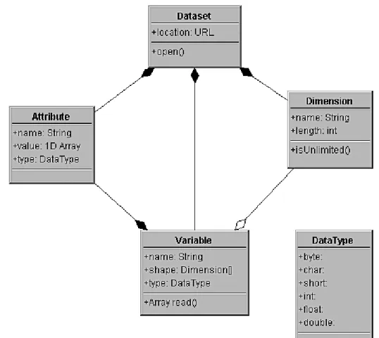
NetCDF 3 files in the classic or 64-bit-offset format can be written as NetCDF 4 files without loosing information, but with taking advantage of the benefits of this newer file format (Rew et al., 2010). Figure 2.2 on page 23 is an UML diagram that represents the NetCDF 3 classic data model (Caron & Domenico, 2006).
Classic format
The NetCDF classic format is the original binary format for all versions of NetCDF and was the only format available until the release of NetCDF ver-sion 3.6.0 in 2004. For the time period between 1989 and 2004, the NetCDF classic format was the only existing NetCDF format. Due to the fact that backward compatibility is guaranteed, data in this format will always re-main accessible by any newer version of NetCDF. Since it is the first format of NetCDF that was released, data in this format can be accessed by any third-party software that uses an older NetCDF library version which do not recognize the newer NetCDF 64-bit offset format or the NetCDF 4 format yet. Hence it is the most portable of the existing formats, and still the de-fault format of NetCDF. Thereof Unidata recommends the NetCDF classic format for data archiving and distribution (Rew et al., 2010; Rew, n.d.).
The NetCDF classic format consists of dimensions, attributes, variables and supports the six data types char, byte,short, int, float and double
(Hartnett, 2009; Rew et al., 2010).
1IOOS: