Journal of Coastal Research SI 56 524 - 528 ICS2009 (Proceedings) Portugal ISSN 0749-0258
Tides in Torres Strait
C. J. Lemckert, J. Zier and J. Gustafson
Griffith School of Engineering Griffith University
Queensland, Australia
Email: [email protected]
ABSTRACT
LEMCKERT,C.J.,ZIER,J.and GUSTAFSON, J., 2009. Tides in Torres Strait. Journal of Coastal Research, SI 56
(Proceedings of the 10th International Coastal Symposium), 524 – 528. Lisbon, Portugal, ISSN 0749-0258. The indigenous communities resident in Torres Strait, a remote multi-island region located off the northern tip of mainland Australia, are exposed to a broad array of natural events that are compounded by the unique tidal influences from both the Pacific and Indian Oceans and, more recently, possible influences of climate change as well. Torres Strait consists of 16 main inhabited islands, which presently have an inadequate mapping capability due to the lack of a suitable co-ordinate, height and tide datum. As a result, existing mapping can not be used for management of and response to predicted events related to tsunami, storm surge and sea level rise. This paper reports on a unique and comprehensive tidal study designed to quantify the tidal properties in Torres Strait, along with the establishment of a co-ordinate, height and tide datum that will establish a fundamental level of spatial infrastructure to support all management and planning functions. Similar spatial infrastructure is already established elsewhere in Australia. Tide data were established from readings derived from sea-bed tide gauges deployed on most of the inhabited islands. The tide gauges were deployed for a minimum of 35 days in order to derive the main tidal constituents. Analysis of the tidal data reveals that highly complex variations occur across this remote island region, and that further studies will be essential to fully surveying the region’s bathymetry in order to develop accurate predictive models.
ADITIONAL INDEX WORDS:Tides, Torres Strait, Australia
INTRODUCTION
Many Torres Strait island communities are under severe threat from rapid increases in sea level as the result of climate change driven events. The rises may either be in the form of short term storm events, or longer term sustained level rises, with either one having possible severe and sustained impacts.
While large countries have various options to respond to such sea level rises, small island communities do not, and along with their limited gross domestic product (GDP) they must choose any response actions with great care. The more the small communities know about their own land and the influence sea level rise can have on it the better they can plan for their own future. While it may sound simple, one of the main things island managers and decision makers need to know is how high their land is above mean sea level. This may appear to be an easy thing to determine, but often such information is not available and therefore it must be obtained.
The aim of this paper is to present the findings from an initial study of the water levels and tidal properties derived from water level measurements made on various (15) islands (all of which have low levels of inhabitants) within the remote Torres Strait region, Australia. The project was driven by the desire to develop the appropriate knowledge and data base required to help better understand this remote and valuable region off the northern tip of the Australian mainland. The paper will first describe the Torres Strait region and then discuss how the data were collected. It will then present the results obtained and discuss the outcomes,
including the need to ensure that researchers fully respect the local communities they visit and work in so that their activities will have sustained positive impacts.
SITE DESCRIPTION
Torres Strait is a shallow water coastal region located off the northern tip of Queensland, Australia (Figure 1), and is bounded by Papua New Guinea to the north, the Great Barrier Reef and Coral Sea east and the Arafura Sea to the west (HARRIS et al. 2008
and HUGHES et al, 2008). The region consists of 274 islands, of
which 16 are inhabited, sparsely distributed islands whose population does not exceed 7,106 inhabitants. As noted by HUGHES et al, (2008) the Torres Strait covers a political boundary between Australia, Papua New Guinea and Indonesia, and is a major shipping route between the northern ports of Australia, Southeast Asia and the Pacific and it has valuable fisheries and sensitive seagrass habitats (WILLIAMS and STAPLES, 1990; HAYWOOD et al, 2007; HEAP AND SBAFFI 2008). As noted by
WOODROFFE et al., (2000) many of the islands and various reefs that are located throughout the region have fringing reefs that are elongated up to 18km in an east–west direction. The water depth in Torres Strait is shallow with large areas in the range 6–9m deep, but there exists navigable shipping channels with depths up to 25m deep (WOLANSKI et al., 1988 and HEMER et al., 2004). This
complex bathymetry along with the various boundary conditions (fixed coastal and moving seas) makes the hydrodynamic properties within the region highly complex and difficult to model (WOLANSKI et al and SAINT-CAST, 2008).
Tides in Torres Strait
METHODOLOGY
For this study, 30 KPSI absolute pressure gauges (continuously recording absolute water pressure and the temperature of ambient water every 2 minutes) were initially deployed on 15 islands (with one island having 2 deployment sites) in the Torres Strait over a minimum deployment period of 35 days starting on 27 February to 18 July 2008. Two sensors were deployed on each site in order to overcome any unsuspecting instrument failures. Additionally 15 KPSI barometric pressure sensors (recording absolute ambient atmospheric pressure and air temperature) were deployed at each island for the same time period for the correction of atmospheric pressure and to gain an understanding of small-scale atmospheric dynamics of the region. Each deployment was accompanied by a 24h tide board observation period for calibration and verification purposes. Height differences and connections to land-based survey markers have been established by using standard surveying techniques.
The islands included in the project were Boigu, Dauan, Saibai, Stephen (with the alternate name of Ugar), Murray (Mer), Darnley (Erub), Hammond (Keriri), Thursday (Waiben), Badu, Mabuiag, Yam (Iama), Yorke, (Masig), Coconut (Poruma), Sue (Warraber) and Moa (which has the communities of Kubin and St. Paul’s) (see Fig.1).
Due to the remote location of the islands and the unknown conditions on the islands, deployment set-up and technique often had to be decided on the island, and were subject to safety issues,
as the waters in the Torres Strait are a well-known habitat of various shark species. Instruments were either deployed on the bed or attached to a fixed structure (the latter was very limited).
Of the 15 islands instrumented it was found that at the time of instrument recovery three sets of instruments were not locatable – two of which were from one island (Moa) and the other from Dauan Island. Therefore, data will only be presented for the remaining 13 islands. Data presented in this paper are from only one of the underwater pressure sensors.
One aspect of the work that warrants a particular mention was the strong need and desires to engage the local communities in the project. There were many stories told of how “outsiders” would fly in and do their research and then fly out without actively seeking support and involvement from the land owners. This could create tension and result in research work being denied. Every effort was made to involve the local communities. This included asking them to assist with the deployment process, giving talks to all the island communities on what we were trying to do and achieve, and how it would benefit them in the long term. Indeed as noted by JONES et al (2008) that it was necessary to
respect people, culture, beliefs, country and views and to build partnerships based on mutual understanding, which is of course only common sense. However, in these isolated environments it is certainly highly important and cannot be overlooked. In keeping with JONES et al (2008) the relationships we developed are likely
to lead to long term collaborations and benefits.
Figure 1. Map of Torres Strait showing the major islands (Map source is Google Earth, 2009). Also shown are plots of the tidal components for each of the islands data were successfully collected on. Each graph represents the relative tidal component elevations () for O1, K1, M2 and S2, respectively (from left to right), and then the component phases () for O1, K1, M2 and S2 (from left to right), respectively. The actual values are presented in Table 1. The mainland to the south is Australia and to the north is Nu Guinea. The map also shows the region has a large number of shallow reefs to the west of Torres Strait (often exposed at low tide).
Lemckert et al.
RESULTS
The recorded water level data were reported back to the appropriate authorities for future analysis and reporting purposes. From the data collected on the Torres Strait Islands it was possible to derive the mean sea water levels and the primary tidal constituents – O1, K1, M2 and S2. The mean water level data will not be discussed here except to say that the islands now have a known reference level for the recording period.
Figure 2 presents the water level data collected on Murray Island, which was the most easterly island studied. The data shows strong mixed tide behaviour with high springs and low neaps. Both semi-diurnal and diurnal components are obvious and significant.
Figure 3 presents the water level data collected on Badu Island, which was the most westerly island studied. The collected data reveals significantly weaker mixed tide behaviour than that of the more easterly Murray Island (Figure 2), with the diurnal components dominating over the semi-diurnal components. There are still high spring and low neap tides. The tidal range on both of the islands remains similar.
Also shown in Figures 2 and 3 are the water temperature signals recorded by the tide gauges. As the Torres Strait region is generally vertically well mixed, due to the high currents encountered, the fluctuations are primarily the result of horizontal advection processes.
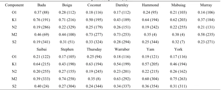
Analysis of the tidal components for each island were determined using 'Worldtides 2008' supplied by John D. Boon, Marine Consultant LLC ("the Company"), P.O. Box 1042, Gloucester Point, VA 23062 USA. The raw water level data were corrected for atmospheric pressure fluctuations using the data derived from the locally deployed barometers – thus ensuring minimal errors due to pressure fluctuations that may occur across the Torres Strait region. The tidal analysis results are presented graphically in Figure 1 (4 components) and numerically in Table 1 (5 components for more completeness).
DISCUSSION
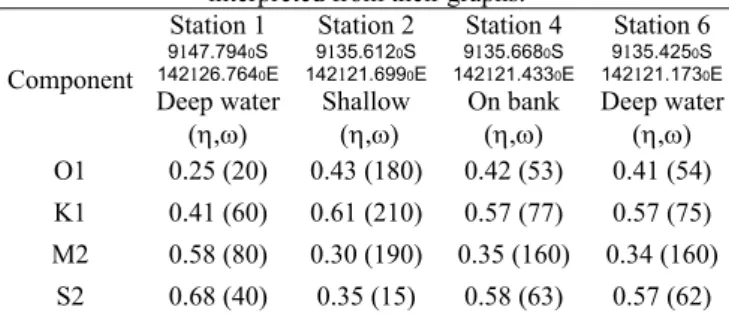
The tides recorded in Torres Strait were in keeping with those previously recorded. In 2004 HUGHES et al (2008) conducted a
short term tidal survey on the western side of Torres Strait that could be used to examine the influence of shallow water effects – in this case sand banks. Their derived tidal constituent data is presented in Table 2. Their Stations 1, 2 and 4 provide a regional view of tide behaviour in the vicinity of a sand bank located southeast of Turnagain Island. Proceeding from east to west, their Stations are ordered 1, 4 then 2, with station 6 being very close to
4. It is seen in Table 2 that the diurnal constituents increase in amplitude from east to west, whereas the semi-diurnal amplitudes decrease. As clearly shown in Figure 1 this is the same trend as observed in this study. Indeed, on the eastern side of the strait the M2 components are amplitude > 0.5 with a phase ~ 250 deg. while dominant diurnal components (K1) was typically > 0.4 with a phase ~ 180 deg. That is, they are out of phase by nearly 90 deg.
On the western side of the strait the M2 components are significantly reduced with ~ 0.4 with a phase ~ 100 deg. while dominant diurnal components (K1) was typically ~ 0.6 with a phase ~ 200 deg. Like the eastern side the semi-diurnal and diurnal components are also generally out of phase.
In addition to the east west trend there is also evidence of strong shallow water and island blocking effects. An example of this can be seen when considering the three most westerly islands (Hammond, Gadu and Mabuiag) where, while they have similar tidal constituent trends, there are indeed variations likely to result of local influences.
There was a definite strong demarcation between the diurnal and semi-diurnal regions at the chain of islands (including Thursday Island) going along the NNE-SSW axis at the centre of the strait. This is the shallowest region and one with the most islands – thus a region of major flow constriction due to bed friction influences.
Hughes et al (2008) noted that the trend on the diurnal and semi-diurnal components was consistent with the area being located close to the boundary between the predominantly semi-diurnal amphidrome situated in the Coral Sea and the amphidrome with larger diurnal constituents in the Arafura Sea. The two seas are also out of phase with each other (with variations in M2 180 deg) and show little correlation in the tidal records either side of the Strait (HEMER et al 2004).
From the results of HEMER et al (2004) and HUGHES et al
(2008), and the modeling work of SAINT-CAST (2008)), it is evident that there are large, tidally varying, water surface slopes Figure 2. Raw recorded water level and water temperature by the tide gauge at Murray Island
Figure 3. Raw recorded water level and water temperature by the tide gauge at Badu Island
Table 2: Tidal Constituents for the sites described by HUGHES et
al (2008).The station numbers are those presented by the authors while the values presented for stations 1 and 2 have been
interpreted from their graphs. Component Station 1 9147.7940S 142126.7640E Deep water (,) Station 2 9135.6120S 142121.6990E Shallow (,) Station 4 9135.6680S 142121.4330E On bank (,) Station 6 9135.4250S 142121.1730E Deep water (,) O1 0.25 (20) 0.43 (180) 0.42 (53) 0.41 (54) K1 0.41 (60) 0.61 (210) 0.57 (77) 0.57 (75) M2 0.58 (80) 0.30 (190) 0.35 (160) 0.34 (160) S2 0.68 (40) 0.35 (15) 0.58 (63) 0.57 (62)
Tides in Torres Strait
across the Torres Strait, which is consistent with the strong tidal flows encountered in the region. The strong flows also indicate that the tides are unable to propagate completely across the Strait, with about 30% of the tidal wave being transmitted and the rest dissipated through friction (WOLANSKI et al., 1988).
As detailed in HEMER et al (2004) a number of non-tidal
sea-level oscillations exist within the Torres Strait, and include: (i) 50 cm amplitude oscillations in the Gulf of
Carpentaria driven by cyclones (which occur late in the summer season) in the Arafura Sea;
(ii) Storm surges generated on either side of the Strait as the result of summer cyclones and trade winds; and
(iii) 15 cm amplitude large low-frequency oscillations on the northern Great Barrier Reef Shelf resulting from various coastal wave mechanisms.
All of these have been concluded to be incoherent on either side of the strait, which therefore add to tidal properties and the residuals in any tidal analysis process. A new possible sea level oscillation (positive only) may be due to rapid climate change induced sea level rise. Exactly how any positive change in sea level will influence the region has yet to be determined, but modeling efforts are continuing (SAINT-CAST, 2008). One
possibility is that if the sea level was to rise, the influence of the bed on the tides would be reduced and the tides would have a freer passage through Torres Strait However, but given the size of the region the effects may be small.
CONCLUSIONS
Tidal properties within Torres Strait have been determined from recorded water elevation data on 13 islands. Mean water levels were assed for future Island mapping activities. Tidal analysis revealed that the region has a highly complex character with both semi-diurnal and diurnal properties having a major impact, but varying in importance depending on the exact location within the strait. This complex nature means that it is not possible to predict tides on all the un-studied islands to any high degree of accuracy. Further tidal studies are therefore recommended.
The study also revealed the necessity to actively involve the local communities in the data collection process. This involvement activity was undertaken from the start, with all level of local governments involved, which generally assumed a smooth sampling operation. In such an isolated region as this, where local
values and strong traditional beliefs play an important role in every day life, the interaction between all parties can lead to benefits to all.
LITERATURE CITED
HARRIS, P.T. BUTLER, A. J. AND COLES, R. G. (2008) Marine
resources, biophysical processes, and environmental management of a tropical shelf seaway: Torres Strait, Australia– Introduction to the special issue Continental Shelf Research 28, 2113–2116, doi:10.1016/j.csr.2008.03.025 HAYWOOD,M.D.E.,BROWNE,M.,SKEWES,T.,ROCHESTER,W.,
MCLEOD,I.,PITCHER,R.,DENNIS,D.,DUNN,J.,CHEERS,S., WASSENBERG,T. 2007. Improved knowledge of Torres Strait
seabed biota and reef habitats. Report to the Marine and Tropical Sciences Research Facility. Reef and Rainforest Research Centre Limited, Cairns (115 pp.).
HEAP,A.D. AND SBAFFI,L.2008. Composition and distribution of
seabed and suspended sediments in north and central Torres Strait, Australia, Continental Shelf Research 28, 2174–2187, doi:10.1016/j.csr.2008.03.025
HEMER,M.A.,HARRIS,P.T.,COLEMAN,R., AND HUNTER,J., 2004.
Sediment mobility due to currents and waves in the Torres Strait—Gulf of Papua region, Continental Shelf Research, 24, 2297–2316
HUGHES,M.G.,HARRIS,P.T.,HEAP,A. AND HEMER,M.A.2008.
Form drag is a major component of bed shear stress associated with tidal flow in the vicinity of an isolated sand bank, Torres Strait, northern Australia, Continental Shelf Research, doi:10.1016/j.csr.2008.03.042
JONES, A., BARNETT, B. WILLIAMS, A. J., GRAYSON, J.,
BUSILACCHI,S.DUCKWORTH,A.EVANS-ILLIDGE,E.,BEGG,G. A. AND MURCHIE C.D.2008. Effective communication tools
to engage Torres Strait Islanders in scientific research, Continental Shelf Research, 28, 2350–2356, doi:10.1016/j.csr.2008.03.027
SAINT-CAST, F., 2008. Multiple time scale modelling of the
circulation in Torres Strait—Australia. Continental Shelf Research, doi:10.1016/j.csr. 2008.03.035
WOODROFFE, C.D., KENNEDY, D.M., HOPLEY, D., RASMUSSEN, C.E. AND SMITHERS, S.G., 2000. Holocene reef growth in
Torres Strait. Marine Geology 170, 331–346.
WOLANSKI,E.,RIDD,P.,INOUE,M., 1988. Currents through Torres
Strait. Journal of Physical Oceanography 18, 1535–1545. Table 1: Tidal Constituents for Torres Strait Islands (locations are presented in Figure 1). The numbers represent the elevation () and
phase components (.
Component Badu Boigu Coconut Darnley Hammond Mabuiag Murray O1 0.37 (88) 0.28 (112) 0.18 (116) 0.17 (112) 0.24 (95) 0.21 (103) 0.14 (106) K1 0.76 (191) 0.71 (216) 0.50 (195) 0.43 (189) 0.64 (194) 0.62 (203) 0.37 (184) N2 0.19 (286) 0.22 (329) 0.25 (179) 0.26 (151) 0.19 (242) 0.22 (255) 0.21 (131) M2 0.46 (69) 0.44 (100) 0.73 (277) 0.73 (253) 0.35 (4) 0.38 (4) 0.58 (235) S2 0.19 (341) 0.31 (51) 0.33 (324) 0.28 (294) 0.25 (344) 0.32 (7) 0.23 (271)
Saibai Stephen Thursday Warraber Yam York
O1 0.21 (122) 0.17 (105) 0.25 (94) 0.18 (116) 0.19 (121) 0.17 (116) K1 0.64 (215) 0.43 (190) 0.63 (194) 0.54 (199) 0.57 (205) 0.46 (194) N2 0.20 (255) 0.27 (155) 0.19 (245) 0.23 (201) 0.22 (215) 0.26 (162) M2 0.39 (333) 0.74 (258) 0.35 (8) 0.63 (292) 0.60 (304) 0.75 (263) S2 0.40 (24) 0.27 (304) 0.24 (344) 0.34 (337) 0.36 (354) 0.31 (311)
Lemckert et al.
WOLANSKI,E.,NORRO,A. AND KING,B., 1995. Water circulation
in the Gulf of Papua. Continental Shelf Research 15, 185–212.
ACKNOWLEDGEMENTS
This project was funded by the Department of Natural Resources and Water (NRW). We would like to thank NRW staff for their supporting information and help during the study. We also thank the Torres Strait Regional Authority (TSRA) staff for their endless support in the Torres Strait, especially Damian Miley, for his time and effort in assisting us with the project. Appreciation for their time and efforts of our field workers Dr.
Jan-Olaf Meynecke, Fernanda Helfer, Adam Coombes, Joey Roper, Nicholas Harris and Jim Churchill. Further we would like to thank all native title offices, council offices and communities for being granted permission on the islands and for their help and hospitality. Additional thanks go to Nick Cartwright, at the School of Engineering, Griffith University, for his support and help during data analysis, and Kevin Parnell, at James Cook University for his support. Special thanks go again to the People of the Torres Strait for their gifts and hospitality. Without the people of the Torres Strait this project would not have been so successful.